99L Invest,Comments,Sat Pics,Models Thread

This is the general tropical discussion area. Anyone can take their shot at predicting a storms path.

Moderator: S2k Moderators

Forum rules

The posts in this forum are NOT official forecasts and should not be used as such. They are just the opinion of the poster and may or may not be backed by sound meteorological data. They are NOT endorsed by any professional institution or STORM2K. For official information, please refer to products from the National Hurricane Center and National Weather Service.

Help Support Storm2K
Message
Author
WeatherEmperor
S2K Supporter
S2K Supporter
Posts: 4806
Age: 41
Joined: Thu Sep 04, 2003 2:54 pm
Location: South Florida

#121 Postby WeatherEmperor » Sun Sep 25, 2005 6:14 pm

AZS wrote:look at the latest GFS, and south Florida:

http://www.nco.ncep.noaa.gov/pmb/nwprod/analysis/namer/gfs/18/fp0_102.shtml


Interesting GFS run. Are there any other models that show a similar situation?

<RICKY>
0 likes   

User avatar
cinlfla
Category 2
Category 2
Posts: 687
Joined: Mon Aug 16, 2004 7:16 pm
Location: Titusville, Florida on the Spacecoast

#122 Postby cinlfla » Sun Sep 25, 2005 6:20 pm

look at the latest GFS, and south Florida:


Saw that but had not had a chance to post about it yet. It looks like its about 6 or 7 days out, I'm not sure which disturbance its picking up on.
0 likes   

User avatar
wxmann_91
Category 5
Category 5
Posts: 8013
Age: 34
Joined: Fri Jul 15, 2005 2:49 pm
Location: Southern California
Contact:

#123 Postby wxmann_91 » Sun Sep 25, 2005 6:22 pm

Wow, 7 pages for something that's not even an INVEST!!! :eek:

WeatherEmperor wrote:
AZS wrote:look at the latest GFS, and south Florida:

http://www.nco.ncep.noaa.gov/pmb/nwprod/analysis/namer/gfs/18/fp0_102.shtml


Interesting GFS run. Are there any other models that show a similar situation?

<RICKY>


Only the MM5 develops this near the Yucatan channel after curving Rita back out over the GOM.

Many of the other models don't develop this thing or develop this after it moves into the EPAC.
0 likes   

User avatar
Tampa Bay Hurricane
Category 5
Category 5
Posts: 5598
Age: 37
Joined: Fri Jul 22, 2005 7:54 pm
Location: St. Petersburg, FL

#124 Postby Tampa Bay Hurricane » Sun Sep 25, 2005 6:39 pm

The following post is NOT an official forecast and should not be used as such. It is just the opinion of the poster and may or may not be backed by sound meteorological data. It is NOT endorsed by any professional institution including storm2k.org For Official Information please refer to the NHC and NWS products.

This system is entering a very favorable environment with less shear, moist MJO, and high octane waters with high and deep SSTs. As
wxmann57 mentioned earlier, development is possible. In my
opinion given the aforementioned conditions
development is likely, and rapid development is strongly possible.

For these reasons I remain vigilant to this wave. It is very large and
very moist. Environment as described earlier is highly conducive for
development.
Last edited by Tampa Bay Hurricane on Sun Sep 25, 2005 6:47 pm, edited 3 times in total.
0 likes   

User avatar
cycloneye
Admin
Admin
Posts: 148497
Age: 69
Joined: Thu Oct 10, 2002 10:54 am
Location: San Juan, Puerto Rico

#125 Postby cycloneye » Sun Sep 25, 2005 6:42 pm

I posted this earlier in the first pages of thread but I say it again.Anyone who wants to post a forecast about this wave of course can do so but that forecast then has to be posted with a disclaimer. Also a forecast has to have details to backup what you are forecasting.
0 likes   
Visit the Caribbean-Central America Weather Thread where you can find at first post web cams,radars
and observations from Caribbean basin members Click Here

User avatar
Tampa Bay Hurricane
Category 5
Category 5
Posts: 5598
Age: 37
Joined: Fri Jul 22, 2005 7:54 pm
Location: St. Petersburg, FL

#126 Postby Tampa Bay Hurricane » Sun Sep 25, 2005 6:42 pm

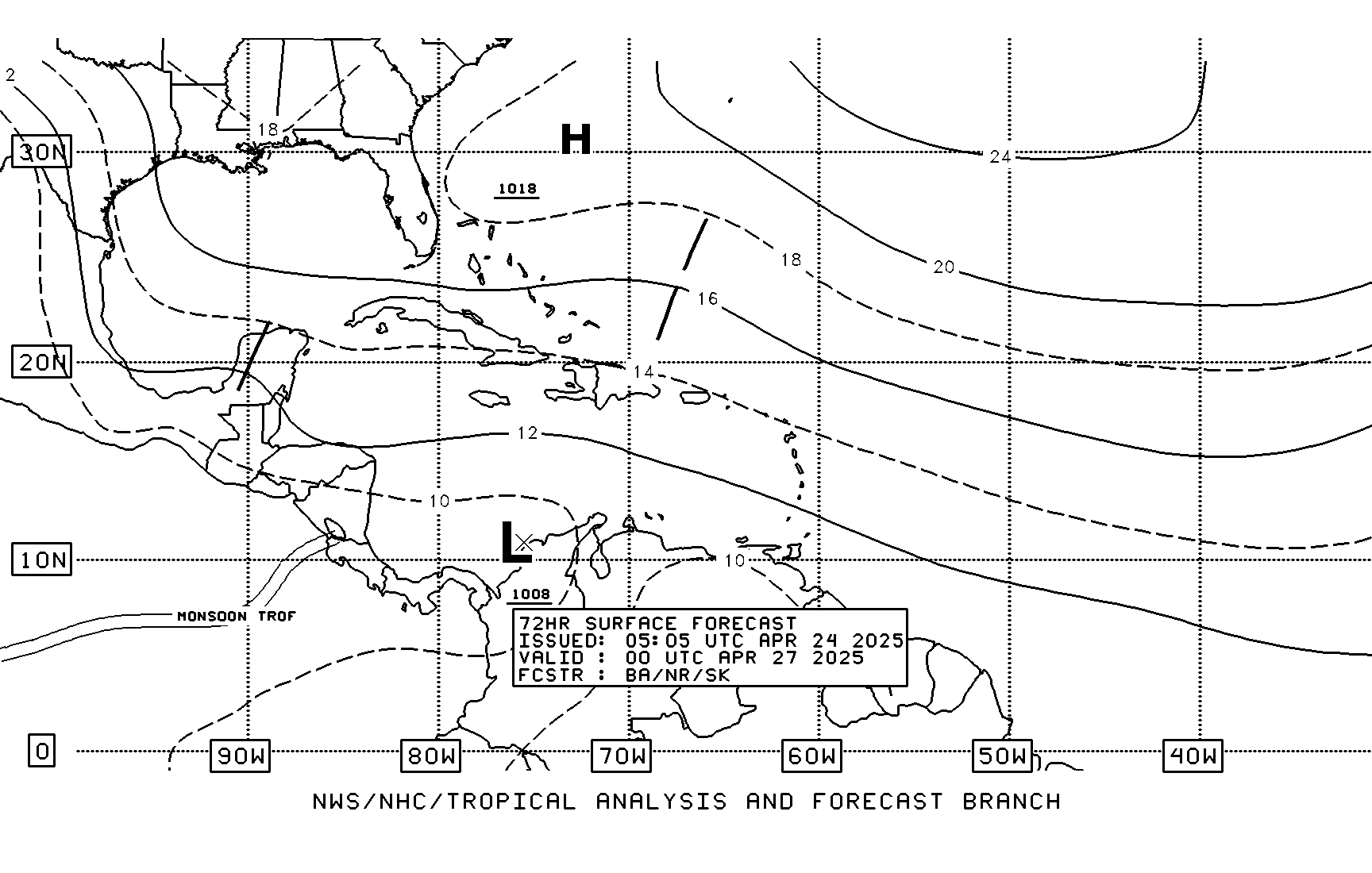
Stationary front off FL West Coast by Wednesday according to
TAFB:

Image
Last edited by Tampa Bay Hurricane on Mon Sep 26, 2005 10:48 am, edited 1 time in total.
0 likes   

JTD
Category 5
Category 5
Posts: 1558
Joined: Sun Nov 02, 2003 6:35 pm

#127 Postby JTD » Sun Sep 25, 2005 6:50 pm

What's the TCHP like in the Eastern/Western Carribbean? Since the area has been largely untouched by our monster 'canes this years it's got to be fairly high. However, I would assume that if a storm were to enter the GOM, it would immediately suffer from the upwelling of Katrina and Rita and weaken? Is this wrong?

To me the TCHP now would only support monster 'canes in the Carribbean and off the east coast of Florida/Georgia.
0 likes   

User avatar
MzShell
Tropical Low
Tropical Low
Posts: 24
Joined: Wed Aug 24, 2005 8:08 pm
Location: Columbia, SC

#128 Postby MzShell » Sun Sep 25, 2005 6:54 pm

cycloneye wrote:I posted this earlier in the first pages of thread but I say it again.Anyone who wants to post a forecast about this wave of course can do so but that forecast then has to be posted with a disclaimer. Also a forecast has to have details to backup what you are forecasting.


Unless the screen name has Mod/Analyst or Pro.Met. under their names, I dont regard it as a forcast. Merely an opinion/prediction.
0 likes   

Patrick99
Category 5
Category 5
Posts: 1772
Joined: Mon May 24, 2004 3:43 pm
Location: SW Broward, FL

#129 Postby Patrick99 » Sun Sep 25, 2005 7:37 pm

ROFLMAO......

......I think the GFS smacks us with *every* storm at some point during its runs. If the GFS was always accurate, Miami wouldn't even be on the map today.

How often have we read "GFS shows ______ in the vicinity of S. FL 6 days out " :D
0 likes   

Brent
S2K Supporter
S2K Supporter
Posts: 38264
Age: 37
Joined: Sun May 16, 2004 10:30 pm
Location: Tulsa Oklahoma
Contact:

#130 Postby Brent » Sun Sep 25, 2005 7:42 pm

Patrick99 wrote:ROFLMAO......

......I think the GFS smacks us with *every* storm at some point during its runs. If the GFS was always accurate, Miami wouldn't even be on the map today.

How often have we read "GFS shows ______ in the vicinity of S. FL 6 days out " :D


It does the same thing with epic blizzards here during the winter at 15-16 days out. If everyone had verified last year, we would have had feet of snow on the ground from December til April. :P
0 likes   
#neversummer

Patrick99
Category 5
Category 5
Posts: 1772
Joined: Mon May 24, 2004 3:43 pm
Location: SW Broward, FL

#131 Postby Patrick99 » Sun Sep 25, 2005 7:45 pm

Brent wrote:
Patrick99 wrote:ROFLMAO......

......I think the GFS smacks us with *every* storm at some point during its runs. If the GFS was always accurate, Miami wouldn't even be on the map today.

How often have we read "GFS shows ______ in the vicinity of S. FL 6 days out " :D


It does the same thing with epic blizzards here during the winter at 15-16 days out. If everyone had verified last year, we would have had feet of snow on the ground from December til April. :P


Oh yeah - I actually remember all those big Southern snow storms that never verified.
0 likes   

User avatar
gatorcane
S2K Supporter
S2K Supporter
Posts: 23703
Age: 47
Joined: Sun Mar 13, 2005 3:54 pm
Location: Boca Raton, FL

#132 Postby gatorcane » Sun Sep 25, 2005 7:53 pm

interesting wave that the GOM may be dealing with down the road, although, still way too early to say at this point.
0 likes   

User avatar
cycloneye
Admin
Admin
Posts: 148497
Age: 69
Joined: Thu Oct 10, 2002 10:54 am
Location: San Juan, Puerto Rico

#133 Postby cycloneye » Sun Sep 25, 2005 8:51 pm

EAST CARIBBEAN SEA TROPICAL WAVE IS ALONG 67W SOUTH OF 20N
MOVING WEST 15 KT. PATCHES OF WIDELY SCATTERED MODERATE
CONVECTION COVERS THE E CARIBBEAN FROM 8N-18N BETWEEN 60W-70W.


8 PM Discussion.

Not much to say about the wave at the discussion.
0 likes   
Visit the Caribbean-Central America Weather Thread where you can find at first post web cams,radars
and observations from Caribbean basin members Click Here

jhamps10

#134 Postby jhamps10 » Sun Sep 25, 2005 8:57 pm

All I am going to say is gee diddn't Charley start out right there? (Please correct me if I am wrong)
0 likes   

User avatar
Portastorm
Storm2k Moderator
Storm2k Moderator
Posts: 9914
Age: 63
Joined: Fri Jul 11, 2003 9:16 am
Location: Round Rock, TX
Contact:

#135 Postby Portastorm » Sun Sep 25, 2005 9:07 pm

wxmann_91 wrote:Wow, 7 pages for something that's not even an INVEST!!! :eek:

WeatherEmperor wrote:
AZS wrote:look at the latest GFS, and south Florida:

http://www.nco.ncep.noaa.gov/pmb/nwprod/analysis/namer/gfs/18/fp0_102.shtml


Interesting GFS run. Are there any other models that show a similar situation?

<RICKY>


Looks to me like the European takes it to the tip of the Yucatan and develops it some.

Only the MM5 develops this near the Yucatan channel after curving Rita back out over the GOM.

Many of the other models don't develop this thing or develop this after it moves into the EPAC.
0 likes   

User avatar
Scott_inVA
Storm2k Forecaster
Storm2k Forecaster
Posts: 1238
Joined: Sat Oct 12, 2002 5:44 pm
Location: Lexington, Virginia
Contact:

#136 Postby Scott_inVA » Sun Sep 25, 2005 9:16 pm

Tampa Bay Hurricane wrote:The following post is NOT an official forecast and should not be used as such. It is just the opinion of the poster and may or may not be backed by sound meteorological data. It is NOT endorsed by any professional institution including storm2k.org For Official Information please refer to the NHC and NWS products.

This system is entering a very favorable environment with less shear, moist MJO, and high octane waters with high and deep SSTs. As
wxmann57 mentioned earlier, development is possible. In my
opinion given the aforementioned conditions
development is likely, and rapid development is strongly possible.

For these reasons I remain vigilant to this wave. It is very large and
very moist. Environment as described earlier is highly conducive for
development.


Maybe I'm just looking for a break in all this :wink: but M/U atmosphere looks totally hostile to Invest 98 getting to the Eastern US, let alone GOM.

Scott
0 likes   

User avatar
seaswing
S2K Supporter
S2K Supporter
Posts: 561
Joined: Sun Aug 31, 2003 11:56 am
Location: High Springs, FL/just NW of Gainesville

#137 Postby seaswing » Sun Sep 25, 2005 9:17 pm

Inotherwords:
Just wondering....where is Nokomis?
0 likes   

User avatar
gatorcane
S2K Supporter
S2K Supporter
Posts: 23703
Age: 47
Joined: Sun Mar 13, 2005 3:54 pm
Location: Boca Raton, FL

#138 Postby gatorcane » Sun Sep 25, 2005 9:21 pm

Maybe I'm just looking for a break in all this but M/U atmosphere looks totally hostile to Invest 98 getting to the Eastern US, let alone GOM.

Scott


He is talking about another possible invest in the Eastern Caribbean not 98L
0 likes   

User avatar
Scott_inVA
Storm2k Forecaster
Storm2k Forecaster
Posts: 1238
Joined: Sat Oct 12, 2002 5:44 pm
Location: Lexington, Virginia
Contact:

#139 Postby Scott_inVA » Sun Sep 25, 2005 9:27 pm

boca_chris wrote:
Maybe I'm just looking for a break in all this but M/U atmosphere looks totally hostile to Invest 98 getting to the Eastern US, let alone GOM.

Scott


He is talking about another possible invest in the Eastern Caribbean not 98L


Gotcha. E Carib better climo but still same issues in m/u atmos.

Scott
0 likes   

User avatar
HurricaneQueen
S2K Supporter
S2K Supporter
Posts: 1011
Age: 80
Joined: Sat Oct 12, 2002 7:36 pm
Location: No. Naples, Fl (Vanderbilt Beach area)

#140 Postby HurricaneQueen » Sun Sep 25, 2005 10:13 pm

I'll answer for inotherwords in case he doesn't see this. He can expound further if he wishes. Nokomis is in SW FL just south of Sarasota and northwest of Port Charlotte/Punta Gorda.

Lynn
0 likes   
GO FLORIDA GATORS


Return to “Talkin' Tropics”

Who is online

Users browsing this forum: kenayers, MarioProtVI and 336 guests