Rita,Comments,Sat Pics,Models Thread

This is the general tropical discussion area. Anyone can take their shot at predicting a storms path.

Moderator: S2k Moderators

Forum rules

The posts in this forum are NOT official forecasts and should not be used as such. They are just the opinion of the poster and may or may not be backed by sound meteorological data. They are NOT endorsed by any professional institution or STORM2K. For official information, please refer to products from the National Hurricane Center and National Weather Service.

Help Support Storm2K
Message
Author
User avatar
Canelaw99
S2K Supporter
S2K Supporter
Posts: 2128
Age: 49
Joined: Tue Aug 31, 2004 8:27 am
Location: Homestead, FL

#801 Postby Canelaw99 » Fri Sep 23, 2005 2:38 pm

He did also say that they're expecting it to come onshore as a major hurricane.
0 likes   

Solaris
Tropical Storm
Tropical Storm
Posts: 222
Joined: Sun Aug 28, 2005 4:54 am

#802 Postby Solaris » Fri Sep 23, 2005 2:41 pm

latest NOAA plane check only found 110 kt in SE quadrant
0 likes   

jpigott
Category 2
Category 2
Posts: 692
Joined: Fri Sep 03, 2004 1:31 pm
Location: North Palm Beach, Florida

#803 Postby jpigott » Fri Sep 23, 2005 2:42 pm

Florida_TSR wrote:Ed is smarter than most of us combined. If he says it is going to weaken then it most likely will.


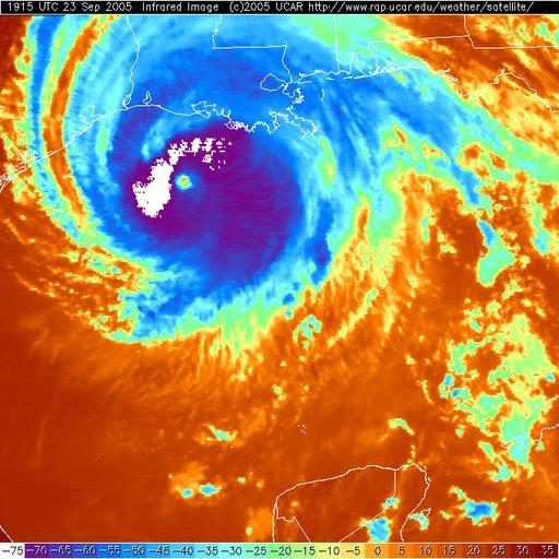
i have no problem with him stating at the time of lanfall NHC projects a weaker cane than what we now have. But what he said is "Rita continues to weaken", when right behind him you can see the blow up of colder cloud tops in the sat image occuring now
0 likes   

oneness
Category 1
Category 1
Posts: 427
Joined: Sat Aug 27, 2005 5:21 am

#804 Postby oneness » Fri Sep 23, 2005 2:43 pm

Eye has cleared again.

Image
Image
Image
0 likes   

User avatar
cjrciadt
S2K Supporter
S2K Supporter
Posts: 1616
Joined: Mon Aug 22, 2005 1:11 pm
Location: Kissimmee, FL

#805 Postby cjrciadt » Fri Sep 23, 2005 3:04 pm

Image
Yeah THE PSYCHO LBAR SENDS RITA TO NYC IN 120hrs. :roll:
Last edited by cjrciadt on Fri Sep 23, 2005 3:24 pm, edited 1 time in total.
0 likes   

User avatar
cjrciadt
S2K Supporter
S2K Supporter
Posts: 1616
Joined: Mon Aug 22, 2005 1:11 pm
Location: Kissimmee, FL

#806 Postby cjrciadt » Fri Sep 23, 2005 3:12 pm

Image
0 likes   

jpigott
Category 2
Category 2
Posts: 692
Joined: Fri Sep 03, 2004 1:31 pm
Location: North Palm Beach, Florida

#807 Postby jpigott » Fri Sep 23, 2005 3:21 pm

cjrciadt wrote:Image


it's almost as if Rita sensed the attempt of dry air intrusion to her west and responded with some of the most intensive convection flareups she has gone thru during her lifecycle
0 likes   

coolwater
Tropical Storm
Tropical Storm
Posts: 135
Joined: Sat Aug 27, 2005 7:34 pm

#808 Postby coolwater » Fri Sep 23, 2005 3:24 pm

Cat 2 when i makes landfall, IMO.
0 likes   

Raebie
Category 3
Category 3
Posts: 822
Joined: Fri Sep 12, 2003 8:00 pm
Location: Charlotte, NC

#809 Postby Raebie » Fri Sep 23, 2005 3:29 pm

I don't know. She's looking mighty peeved for a Cat 2.

Image
0 likes   

Brent
S2K Supporter
S2K Supporter
Posts: 38264
Age: 37
Joined: Sun May 16, 2004 10:30 pm
Location: Tulsa Oklahoma
Contact:

#810 Postby Brent » Fri Sep 23, 2005 3:30 pm

She looks the best she has all day...

and she looks mad. :eek:
0 likes   
#neversummer

Scorpion

#811 Postby Scorpion » Fri Sep 23, 2005 3:32 pm

There will be alot of crow for the people who called for a Cat 2/3 landfall.
0 likes   

dwg71
Category 5
Category 5
Posts: 2349
Joined: Wed Jun 08, 2005 4:34 pm

#812 Postby dwg71 » Fri Sep 23, 2005 3:35 pm

Scorpion wrote:There will be alot of crow for the people who called for a Cat 2/3 landfall.


Still 12+ hours away, that shot is 2 hours old. Eye has become very disorganized since then.
0 likes   

User avatar
jasons2k
Storm2k Executive
Storm2k Executive
Posts: 8250
Age: 52
Joined: Wed Jul 06, 2005 12:32 pm
Location: The Woodlands, TX

#813 Postby jasons2k » Fri Sep 23, 2005 3:35 pm

Not liking this trend...
0 likes   

jkt21787
Category 5
Category 5
Posts: 2061
Joined: Tue Aug 31, 2004 5:27 pm
Location: Memphis, TN

#814 Postby jkt21787 » Fri Sep 23, 2005 3:36 pm

dwg71 wrote:
Scorpion wrote:There will be alot of crow for the people who called for a Cat 2/3 landfall.


Still 12+ hours away, that shot is 2 hours old. Eye has become very disorganized since then.

19:45Z. that is 2:45 PM CDT, less than 1 hour ago.
0 likes   

User avatar
cjrciadt
S2K Supporter
S2K Supporter
Posts: 1616
Joined: Mon Aug 22, 2005 1:11 pm
Location: Kissimmee, FL

#815 Postby cjrciadt » Fri Sep 23, 2005 3:37 pm

0 likes   

Raebie
Category 3
Category 3
Posts: 822
Joined: Fri Sep 12, 2003 8:00 pm
Location: Charlotte, NC

#816 Postby Raebie » Fri Sep 23, 2005 3:40 pm

jkt21787 wrote:
dwg71 wrote:
Scorpion wrote:There will be alot of crow for the people who called for a Cat 2/3 landfall.


Still 12+ hours away, that shot is 2 hours old. Eye has become very disorganized since then.

19:45Z. that is 2:45 PM CDT, less than 1 hour ago.


Whew. Thought my refresh button was broken.

:D
0 likes   

NorthGaWeather

#817 Postby NorthGaWeather » Fri Sep 23, 2005 3:41 pm

dwg71 wrote:
Scorpion wrote:There will be alot of crow for the people who called for a Cat 2/3 landfall.


Still 12+ hours away, that shot is 2 hours old. Eye has become very disorganized since then.


Huh? We must be looking at two different satellites then.
0 likes   

User avatar
stormie_skies
Category 5
Category 5
Posts: 3318
Joined: Tue Aug 12, 2003 9:25 pm
Location: League City, TX

#818 Postby stormie_skies » Fri Sep 23, 2005 3:44 pm

cjrciadt wrote:Image
Yeah THE PSYCHO LBAR SENDS RITA TO NYC IN 120hrs. :roll:


Wow. That is one UGLY model map. If Rita tries to pull an Allison on us.... :grr:
0 likes   

Brent
S2K Supporter
S2K Supporter
Posts: 38264
Age: 37
Joined: Sun May 16, 2004 10:30 pm
Location: Tulsa Oklahoma
Contact:

#819 Postby Brent » Fri Sep 23, 2005 3:44 pm

From the 5pm discussion:

THE WEAKENING TREND APPEARS TO HAVE LEVELED OFF. IT APPEARS THAT THE
EYEWALL REPLACEMENT CYCLES HAVE BEEN THE DOMINANT FACTOR...AS
USUAL...IN CONTROLLING THE INTENSITY FLUCTUATIONS OF RITA. FLIGHT
LEVEL WIND DATA FROM THE RECONNAISSANCE AIRCRAFT INDICATE THAT
MAXIMUM WINDS ARE ABOUT 110 KNOTS. OBJECTIVE T-NUMBERS HAVE
INCREASED A LITTLE SUGGESTING STRONGER WINDS BUT I RATHER WAIT FOR
THESE NUMBERS TO PERSIST. ONLY A SLIGHT WEAKENING IS FORECAST
BEFORE LANDFALL DUE TO SHEAR AND COOLER OCEAN. THIS IS NOT A VERY
SIGNIFICANT CHANGE AND IN FACT...RITA IS STILL FORECAST TO MAKE
LANDFALL AS A CATEGORY THREE HURRICANE.
0 likes   
#neversummer

Sanibel
Category 5
Category 5
Posts: 10385
Joined: Mon Aug 30, 2004 11:06 pm
Location: Offshore SW Florida

#820 Postby Sanibel » Fri Sep 23, 2005 3:45 pm

Katrina-like rebound prior to coast.

Structure/appearance excellent.

Cold tops.

Indication encountering trapping layering to north.

Next wobble N

Cameron should have devastating surge similar to Mississippi...
0 likes   


Return to “Talkin' Tropics”

Who is online

Users browsing this forum: ronjon and 73 guests