I was listening to CBS news today..and they said if these refineries got cat 3 force winds or greater...
The question would be "not how high gas prices will go, but can we buy gas?"
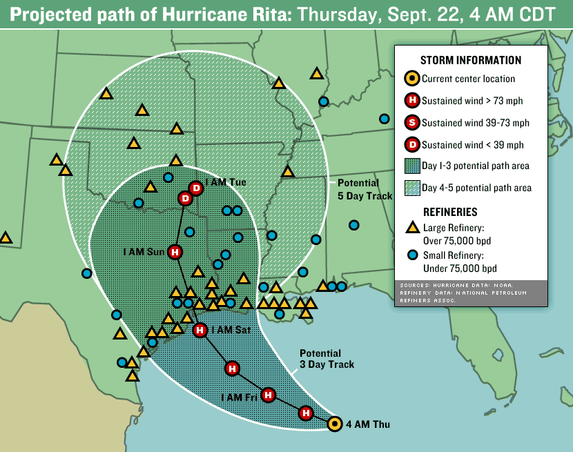
Question is..where are these refineries, obviouslly, further away from coast is better.
THanks
Location of Refineries?
Moderator: S2k Moderators
Forum rules

The posts in this forum are NOT official forecasts and should not be used as such. They are just the opinion of the poster and may or may not be backed by sound meteorological data. They are NOT endorsed by any professional institution or STORM2K. For official information, please refer to products from the National Hurricane Center and National Weather Service.
Location of Refineries?
0 likes

There are many refineries located all along the Texas and West Louisiana coastlines. Here in Houston, (all located on the ship channel) are the following: Exxon (Baytown); Shell (Deer Park), Crown, Lyondell Citgo, Valero, numerous chemical facilities - Texas City refineries: BP, Valero, Marathon - Beaumont: Valero, Motiva - Corpus: Valero, Conoco, Citgo -
Southwest Louisiana - Citgo. These are just the ones I can think of. I'm sure someone will fill in some more. BP Texas City and Exxon Baytown are the 2 largest refineries in the United States. When the Texas City BP plant had a recent explosion it was stated that they product 3% of the US gasoline supply....scary to think of this scenario playing out....
Southwest Louisiana - Citgo. These are just the ones I can think of. I'm sure someone will fill in some more. BP Texas City and Exxon Baytown are the 2 largest refineries in the United States. When the Texas City BP plant had a recent explosion it was stated that they product 3% of the US gasoline supply....scary to think of this scenario playing out....
0 likes
-
thetraveler
- Tropical Depression

- Posts: 65
- Joined: Fri Sep 10, 2004 2:54 pm
- Location: Deep East Texas
There are refineries and chemical plants from Texas City to Baytown west to the 610 loop in Houston. If my memory serves me correctly there are 3 refiners in Texas City, BP, Marathon, and Valero, ExxonMobile in Baytown and Crown in Pasadena, Shell in DeerPark and Valero and LCR in Houston. There more chemical plants than I can remember. The refiners will begin reducing rates sometime tomorrow and then depending on their power ability (cogen plants) they may shut down completely. They may be down for a few days or not at all depending on where the storm goes.
Corpus Christi is another refining area that has 5 Refineries.
Hope that helps.
Corpus Christi is another refining area that has 5 Refineries.
Hope that helps.
0 likes
-
soonertwister
- Category 5

- Posts: 1091
- Joined: Mon Jun 16, 2003 2:52 pm
smashmode wrote:I am just scared.
I remember reading a article in maxim (i know..i know)
But they had in there...potential likely terrorist targets...
and they mentioned...destroying us refineries in houston...that it would destory the US economically for months..if not years
Refineries are intrinsically pretty strong facilities. I know, my father was an engineer in the petroleum industry. Sure, you can see some refinery damage and temporary loss of production, but it's highly unlikely that any hurricane could cause catastrophic destruction in that particular sector of the industry.
0 likes

http://en.wikipedia.org/wiki/List_of_oil_refineries#Texas
Here is a list of the 26 refineries in Texas.
According to the EIA, about 50% of the oil and gas production affected by Katrina is still down three weeks later.
http://tonto.eia.doe.gov/oog/special/images/comp_ivan_katrina.gif
The government says 47% of the nation's refinery capacity is along the gulf coast. Only about 11% was affected by Katrina, therefore 36% is elsewhere in the gulf, and we all know where.
The problem is not necessarily with the facilities themselves, but stuff like roads, electrical infrastructure, etc. also, roads and pipelines out of the area to get finished product out. Also, needless to say, if the workers' homes are destroyed, and they are evacuated, no one to dry the place out once the storm passes.
Hang on to your wallet.
Last edited by pup55 on Tue Sep 20, 2005 7:43 pm, edited 1 time in total.
0 likes
-
wxman57

- Moderator-Pro Met

- Posts: 23166
- Age: 68
- Joined: Sat Jun 21, 2003 8:06 pm
- Location: Houston, TX (southwest)
soonertwister wrote:
Refineries are intrinsically pretty strong facilities. I know, my father was an engineer in the petroleum industry. Sure, you can see some refinery damage and temporary loss of production, but it's highly unlikely that any hurricane could cause catastrophic destruction in that particular sector of the industry.
That's actually not an accurate assessment. Most of the refineries in southeast Texas are customers of ours. Since they refine oil, they must be near the water to offload supplies from ships or pipelines. While the structures themselves might be sturdy, they are VERY vulnerable to flooding from storm surge. A Cat 3 hit near Freeport could put quite a few of them underwater. That happened with the ChevronTexaco refinery in Pascagoula in 1998 - 4 ft of water in the control room after their 12 ft levee was topped. They were out of production for over 2 months. Multiply that by 10 and you'll ltake out a good chunk of the refining capacity of the country. Gas prices could top $10/gallon.
0 likes
"According to the EIA, about 50% of the oil and gas production affected by Katrina is still down three weeks later. "
Yes, but the flooding is still going on in New Orleans. Houston is 40 miles inland and well above sea level. Compared to the NOLA flood, flood sending water through the Houston ship channel would involve a relatively short flood event.
Yes, but the flooding is still going on in New Orleans. Houston is 40 miles inland and well above sea level. Compared to the NOLA flood, flood sending water through the Houston ship channel would involve a relatively short flood event.
0 likes
-
wxman57
- Moderator-Pro Met
- Posts: 23166
- Age: 68
- Joined: Sat Jun 21, 2003 8:06 pm
- Location: Houston, TX (southwest)
BReb wrote:"According to the EIA, about 50% of the oil and gas production affected by Katrina is still down three weeks later. "
Yes, but the flooding is still going on in New Orleans. Houston is 40 miles inland and well above sea level. Compared to the NOLA flood, flood sending water through the Houston ship channel would involve a relatively short flood event.
The duration of the flood doesn't make any difference. Once the water hits vital areas of the refinery, the damage is done. It will take months to repair. And the refineries are NOT 40 miles inland, they're along Galveston Bay and along the Ship Channel, the very places that would get nearly double the storm surge that Galveston would receive. A Cat 3 could put over 25 feet of surge up the Ship Channel. Combine that with 10-15 inches of rain and the refineries will be flooded and damaged.
0 likes
-
wx247

- S2K Supporter

- Posts: 14279
- Age: 42
- Joined: Wed Feb 05, 2003 10:35 pm
- Location: Monett, Missouri
- Contact:
wxman57 wrote:soonertwister wrote:
Refineries are intrinsically pretty strong facilities. I know, my father was an engineer in the petroleum industry. Sure, you can see some refinery damage and temporary loss of production, but it's highly unlikely that any hurricane could cause catastrophic destruction in that particular sector of the industry.
That's actually not an accurate assessment. Most of the refineries in southeast Texas are customers of ours. Since they refine oil, they must be near the water to offload supplies from ships or pipelines. While the structures themselves might be sturdy, they are VERY vulnerable to flooding from storm surge. A Cat 3 hit near Freeport could put quite a few of them underwater. That happened with the ChevronTexaco refinery in Pascagoula in 1998 - 4 ft of water in the control room after their 12 ft levee was topped. They were out of production for over 2 months. Multiply that by 10 and you'll ltake out a good chunk of the refining capacity of the country. Gas prices could top $10/gallon.
*gulp* This is not what I wanted to hear.
0 likes
Personal Forecast Disclaimer:
The posts in this forum are NOT official forecast and should not be used as such. They are just the opinion of the poster and may or may not be backed by sound meteorological data. They are NOT endorsed by any professional institution or storm2k.org. For official information, please refer to the NHC and NWS products.
The posts in this forum are NOT official forecast and should not be used as such. They are just the opinion of the poster and may or may not be backed by sound meteorological data. They are NOT endorsed by any professional institution or storm2k.org. For official information, please refer to the NHC and NWS products.
http://www.theoildrum.com/story/2005/9/20/144722/791
The Oil Drum
Where is the worst place for Rita to hit for the oil and ng industry? I emailed our industry insider that question, here's her response:
The worst tracks are those which put landfall between Freeport and Sabine Pass Texas.
"landfall just east of Houston would be right up refinery alley. Another bad spot is right up through Port Arthur and Beaumont"
0 likes


-
DESTRUCTION5

- Category 5
- Posts: 4430
- Age: 44
- Joined: Wed Sep 03, 2003 11:25 am
- Location: Stuart, FL
-
gtalum

- S2K Supporter
- Posts: 4749
- Age: 50
- Joined: Tue Sep 07, 2004 3:48 pm
- Location: Bradenton, FL
- Contact:
wxman57 wrote:Gas(oline) prices could top $10/gallon.
Wanna bet on that? I bet they don't top $4, and are back below $3 by the end of the year.
As far as natural gas, that is where the true pinch will be. We can always import more refined fuel. From what I understand, natural gas isn't that plentiful elsewhere though.
0 likes
Sometimes we take so much for granted until it is threatened. For instance, take a look at the number of rig platforms off the coast of TX and LA. The gold colored ones are mobile and the grey ones are fixed platform rigs. Thankfully, most will survive intact or have minimal damage, but a few of the mobile rigs will likely drift or possibly get destroyed if they are on the eastern side of Rita and get driven toward land or another fixed rig platform. Something like 20 of them off LA were lost in this way after Katrina.

0 likes
-
Stangfriik
- Tropical Storm

- Posts: 114
- Joined: Tue Jul 26, 2005 2:25 pm
- Location: Daytona Beach, Florida
- Contact:
-
digitaldahling

- Tropical Depression
- Posts: 85
- Joined: Wed Jul 06, 2005 10:45 pm
- Location: Mobile, AL
Re: Location of Refineries?
smashmode wrote:The question would be "not how high gas prices will go, but can we buy gas?"
This report was released shortly after assessing damage from Katrina:
The gulf accounts for about 23% of the USA's domestic natural gas and 30% of its oil, according to the U.S. Department of the Interior's Minerals Management Service. But the storm interrupted 95% of gulf oil production
and 88% of the outer continental shelf's natural gas production, the agency said.
Link of a PDF presentation documenting damage, losses, etc. if anyone's interested.
http://home.comcast.net/~unlimitedimagination/onlinestorage/Katrina_Drifting_MODUs_and_Damage.pdf
One other thing. A coastal refinery got a visit from their state's Homeland Security division yesterday. Seems HS is considering rationing gasoline use after Rita. Refinery officials told them it would be a grave mistake and would cause widespread panic to the population. Rumors were spreading yesterday morning and lines were already forming in at least two states affected by Katrina. Homeland Security, in any state, needs to rethink that position.
Last edited by digitaldahling on Thu Sep 22, 2005 12:23 pm, edited 1 time in total.
0 likes
The folks who are paid to know about this stuff don't seem to think it's quite as catastrophic a situation as laypeople.
The NY Times reports that:
Spot gasoline prices at the New York Harbor, which is close to what many wholesalers and retailers pay to buy gas, were up 13.19 cents, to $2.148 a gallon, at midday (Thursday).
...
Industry officials and analysts say Rita could potentially be stronger than Katrina, but it may cause less long-lasting damage to the nation's energy infrastructure.
Texas has more than a quarter of the nation's 17 million barrels a day of refining capacity and much of it is on the coast. But it is spread over wide swath of land from as far south as the Mexican border to the western shores of Louisiana.
"The 4.5 million barrels is spread out across a lot of distance and even the concentration in Houston is still well back from the coast," Mr. Pickering said.
Houston is about 50 miles inland from the shore and is buffeted by barrier islands like Galveston, unlike New Orleans, which has always been extremely susceptible to flooding because it is below sea level and sandwiched below sea level between a large lake and a river.
- end quote -
This is somewhat comforting to me- the traders know full well today what we are dealing with and for spot gas prices to only be going up 13 dollars a barrel tells me it's not as apocalyptic a situation as I feared. Some of the refineries are a good distance from shore, and some of them have sea walls. Apparently some people in the know expect them to survive the storm pretty well.
0 likes
I work for a light crude refactionator in Mt Belvieu. Wednesday they shut the plant down. It will remain unmanned until after the hurrican has passed. Wednesday I made a call to the plant because my shift was friday and where I live we were told to start evacuating. My supervisor said to call in when Iget where I'm going and to call in wbefore trying to come back to work.
There is no way we could have ridden out a cat 1 hurricane out there, tin roof on the control room. Just a little bit better built then a mobil home!
There is no way we could have ridden out a cat 1 hurricane out there, tin roof on the control room. Just a little bit better built then a mobil home!
0 likes
Who is online
Users browsing this forum: No registered users and 118 guests