Invest 95L,Comments,Sat Pics,Models Thread

This is the general tropical discussion area. Anyone can take their shot at predicting a storms path.

Moderator: S2k Moderators

Forum rules

The posts in this forum are NOT official forecasts and should not be used as such. They are just the opinion of the poster and may or may not be backed by sound meteorological data. They are NOT endorsed by any professional institution or STORM2K. For official information, please refer to products from the National Hurricane Center and National Weather Service.

Help Support Storm2K
Message
Author
User avatar
SkeetoBite
S2K Supporter
S2K Supporter
Posts: 515
Age: 59
Joined: Fri Sep 03, 2004 8:25 am
Contact:

#161 Postby SkeetoBite » Wed Sep 14, 2005 9:02 pm

skysummit wrote:Ok....I have many bookmarks where I get graphics from and text from. What I'm getting at, is do you find the text output any useful, or do you normally just wait for a graphic output?


A lot of the folks on these boards can get an idea of the track by just looking at the text version, however, many more cannot and need the graphics.

The text includes the SHIPS and DSHIPS winds speed models for each plot in the forecast. I think only wunderground.com currently includes these numbers in their graphics. We may add them if folks find this useful.

Since you're likely about to ask... SHIPS are wind intensity forecast ignoring land under the storm. DSHIP accounts for the weakening affect land has on a hurricane over land and follows SHIPS until the plots take the storm over land.

Hope that helps.
0 likes   

Scorpion

#162 Postby Scorpion » Wed Sep 14, 2005 9:02 pm

It will likely be a Caribbean storm, and would gather some good strength over those high octane waters.
0 likes   

Brent
S2K Supporter
S2K Supporter
Posts: 38266
Age: 37
Joined: Sun May 16, 2004 10:30 pm
Location: Tulsa Oklahoma
Contact:

#163 Postby Brent » Wed Sep 14, 2005 9:07 pm

It looks REALLY good tonight. If this keeps up, I say TD tomorrow.
0 likes   
#neversummer

User avatar
skysummit
S2K Supporter
S2K Supporter
Posts: 5305
Age: 49
Joined: Tue Aug 31, 2004 11:09 pm
Location: Ponchatoula, LA
Contact:

#164 Postby skysummit » Wed Sep 14, 2005 9:07 pm

SkeetoBite wrote:
skysummit wrote:Ok....I have many bookmarks where I get graphics from and text from. What I'm getting at, is do you find the text output any useful, or do you normally just wait for a graphic output?


A lot of the folks on these boards can get an idea of the track by just looking at the text version, however, many more cannot and need the graphics.

The text includes the SHIPS and DSHIPS winds speed models for each plot in the forecast. I think only wunderground.com currently includes these numbers in their graphics. We may add them if folks find this useful.

Since you're likely about to ask... SHIPS are wind intensity forecast ignoring land under the storm. DSHIP accounts for the weakening affect land has on a hurricane over land and follows SHIPS until the plots take the storm over land.

Hope that helps.


Thanks, you answered my question! :D By the way, EXCELLENT website you guys have! Keep it up!!!
0 likes   

User avatar
cjrciadt
S2K Supporter
S2K Supporter
Posts: 1616
Joined: Mon Aug 22, 2005 1:11 pm
Location: Kissimmee, FL

#165 Postby cjrciadt » Wed Sep 14, 2005 9:08 pm

Image
The models are all over this invest. :roll: The GFD models goes due N. you cant see it the legend is in the way.
0 likes   

MiamiensisWx

#166 Postby MiamiensisWx » Wed Sep 14, 2005 9:09 pm

Scorpion wrote:It will likely be a Caribbean storm, and would gather some good strength over those high octane waters.


True... however, not just one factor influences this system's strength. Other factors, notably shear, need to be factored in as well.
0 likes   

Coredesat

#167 Postby Coredesat » Wed Sep 14, 2005 9:26 pm

Image

Only light shear over the Caribbean at the moment. The GFS and CMC call for a slight increase in shear, but they relax it after 36-48 hours.
0 likes   

THead
S2K Supporter
S2K Supporter
Posts: 790
Joined: Mon Aug 30, 2004 5:09 pm
Location: Lauderhill, Fla./Jefferson, Ga.

#168 Postby THead » Wed Sep 14, 2005 9:37 pm

Light shear, hot water, record breaking season.......sigh......is it here we go again? Wonder what we'll be talking about 4-5 days from now. It is kind of far south though isn't it?
0 likes   

Brent
S2K Supporter
S2K Supporter
Posts: 38266
Age: 37
Joined: Sun May 16, 2004 10:30 pm
Location: Tulsa Oklahoma
Contact:

#169 Postby Brent » Wed Sep 14, 2005 9:38 pm

Where's the TWO???
0 likes   
#neversummer

User avatar
cycloneye
Admin
Admin
Posts: 148498
Age: 69
Joined: Thu Oct 10, 2002 10:54 am
Location: San Juan, Puerto Rico

#170 Postby cycloneye » Wed Sep 14, 2005 9:41 pm

Brent remember that they are very busy with 3 cyclones 2 in the EPAC and Ophelia.
0 likes   
Visit the Caribbean-Central America Weather Thread where you can find at first post web cams,radars
and observations from Caribbean basin members Click Here

Coredesat

#171 Postby Coredesat » Wed Sep 14, 2005 9:48 pm

THead wrote:Light shear, hot water, record breaking season.......sigh......is it here we go again? Wonder what we'll be talking about 4-5 days from now. It is kind of far south though isn't it?


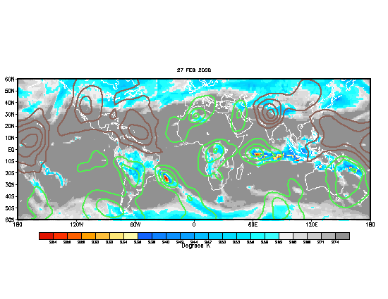
That's not all. Wet MJO is slowly beginning to enter the Atlantic basin:

Image
0 likes   

Brent
S2K Supporter
S2K Supporter
Posts: 38266
Age: 37
Joined: Sun May 16, 2004 10:30 pm
Location: Tulsa Oklahoma
Contact:

#172 Postby Brent » Wed Sep 14, 2005 10:10 pm

10:30pm TWO:

THE TROPICAL WAVE LOCATED ABOUT 1100 MILES EAST-SOUTHEAST OF THE
SOUTHERN WINDWARD ISLANDS CONTINUES TO SHOW SIGNS OF ORGANIZATION
AS IT MOVES WESTWARD AT 10-15 MPH. THIS LARGE SYSTEM HAS THE
POTENTIAL TO BECOME A TROPICAL DEPRESSION OVER THE NEXT COUPLE OF
DAYS.
0 likes   
#neversummer

User avatar
skysummit
S2K Supporter
S2K Supporter
Posts: 5305
Age: 49
Joined: Tue Aug 31, 2004 11:09 pm
Location: Ponchatoula, LA
Contact:

#173 Postby skysummit » Wed Sep 14, 2005 10:14 pm

Brent wrote:10:30pm TWO:

THE TROPICAL WAVE LOCATED ABOUT 1100 MILES EAST-SOUTHEAST OF THE
SOUTHERN WINDWARD ISLANDS CONTINUES TO SHOW SIGNS OF ORGANIZATION
AS IT MOVES WESTWARD AT 10-15 MPH. THIS LARGE SYSTEM HAS THE
POTENTIAL TO BECOME A TROPICAL DEPRESSION OVER THE NEXT COUPLE OF
DAYS.


Wow....they really get into it heh? I could've wrote that outlook. :roll:
0 likes   

Brent
S2K Supporter
S2K Supporter
Posts: 38266
Age: 37
Joined: Sun May 16, 2004 10:30 pm
Location: Tulsa Oklahoma
Contact:

#174 Postby Brent » Wed Sep 14, 2005 10:16 pm

skysummit wrote:
Brent wrote:10:30pm TWO:

THE TROPICAL WAVE LOCATED ABOUT 1100 MILES EAST-SOUTHEAST OF THE
SOUTHERN WINDWARD ISLANDS CONTINUES TO SHOW SIGNS OF ORGANIZATION
AS IT MOVES WESTWARD AT 10-15 MPH. THIS LARGE SYSTEM HAS THE
POTENTIAL TO BECOME A TROPICAL DEPRESSION OVER THE NEXT COUPLE OF
DAYS.


Wow....they really get into it heh? I could've wrote that outlook. :roll:


Copy-paste. :lol:

and it was late... :wink:
0 likes   
#neversummer

User avatar
jasons2k
Storm2k Executive
Storm2k Executive
Posts: 8250
Age: 52
Joined: Wed Jul 06, 2005 12:32 pm
Location: The Woodlands, TX

#175 Postby jasons2k » Wed Sep 14, 2005 10:18 pm

skysummit wrote:
Brent wrote:10:30pm TWO:

THE TROPICAL WAVE LOCATED ABOUT 1100 MILES EAST-SOUTHEAST OF THE
SOUTHERN WINDWARD ISLANDS CONTINUES TO SHOW SIGNS OF ORGANIZATION
AS IT MOVES WESTWARD AT 10-15 MPH. THIS LARGE SYSTEM HAS THE
POTENTIAL TO BECOME A TROPICAL DEPRESSION OVER THE NEXT COUPLE OF
DAYS.


Wow....they really get into it heh? I could've wrote that outlook. :roll:


In their defense so many of these come and go, not just in one year, but over the course of many years, it's best not to write War & Peace for every wave out there, esp. while we have a hurricane with the eyewall on the coast as we speak (er type...). They got bigger fish to fry at the moment.
0 likes   

User avatar
hurricanefloyd5
Category 5
Category 5
Posts: 1659
Age: 45
Joined: Sun May 02, 2004 10:53 am
Location: Spartanburg
Contact:

#176 Postby hurricanefloyd5 » Wed Sep 14, 2005 10:19 pm

when will Philippe form soon i hope!!!!!!!!!!!!!!!!!!! :D
0 likes   

User avatar
skysummit
S2K Supporter
S2K Supporter
Posts: 5305
Age: 49
Joined: Tue Aug 31, 2004 11:09 pm
Location: Ponchatoula, LA
Contact:

#177 Postby skysummit » Wed Sep 14, 2005 10:20 pm

jschlitz wrote:
skysummit wrote:
Brent wrote:10:30pm TWO:

THE TROPICAL WAVE LOCATED ABOUT 1100 MILES EAST-SOUTHEAST OF THE
SOUTHERN WINDWARD ISLANDS CONTINUES TO SHOW SIGNS OF ORGANIZATION
AS IT MOVES WESTWARD AT 10-15 MPH. THIS LARGE SYSTEM HAS THE
POTENTIAL TO BECOME A TROPICAL DEPRESSION OVER THE NEXT COUPLE OF
DAYS.


Wow....they really get into it heh? I could've wrote that outlook. :roll:


In their defense so many of these come and go, not just in one year, but over the course of many years, it's best not to write War & Peace for every wave out there, esp. while we have a hurricane with the eyewall on the coast as we speak (er type...). They got bigger fish to fry at the moment.


I realize that, but this is not no ordinary wave...have you seen this thing? I guess they're saving their award winning outlooks for the next week when this wave really gets going.
0 likes   

User avatar
cinlfla
Category 2
Category 2
Posts: 687
Joined: Mon Aug 16, 2004 7:16 pm
Location: Titusville, Florida on the Spacecoast

#178 Postby cinlfla » Wed Sep 14, 2005 10:21 pm

Looks like there is a good bit of convection with 95l, is it possible we could have a depression in the morning?
0 likes   

User avatar
skysummit
S2K Supporter
S2K Supporter
Posts: 5305
Age: 49
Joined: Tue Aug 31, 2004 11:09 pm
Location: Ponchatoula, LA
Contact:

#179 Postby skysummit » Wed Sep 14, 2005 10:22 pm

cinlfla wrote:Looks like there is a good bit of convection with 95l, is it possible we could have a depression in the morning?


I'll put my money on tomorrow night. It's really looking great right now. All day today it's been looking better and better.
0 likes   

User avatar
jasons2k
Storm2k Executive
Storm2k Executive
Posts: 8250
Age: 52
Joined: Wed Jul 06, 2005 12:32 pm
Location: The Woodlands, TX

#180 Postby jasons2k » Wed Sep 14, 2005 10:23 pm

skysummit wrote:
jschlitz wrote:
skysummit wrote:
Brent wrote:10:30pm TWO:

THE TROPICAL WAVE LOCATED ABOUT 1100 MILES EAST-SOUTHEAST OF THE
SOUTHERN WINDWARD ISLANDS CONTINUES TO SHOW SIGNS OF ORGANIZATION
AS IT MOVES WESTWARD AT 10-15 MPH. THIS LARGE SYSTEM HAS THE
POTENTIAL TO BECOME A TROPICAL DEPRESSION OVER THE NEXT COUPLE OF
DAYS.


Wow....they really get into it heh? I could've wrote that outlook. :roll:


In their defense so many of these come and go, not just in one year, but over the course of many years, it's best not to write War & Peace for every wave out there, esp. while we have a hurricane with the eyewall on the coast as we speak (er type...). They got bigger fish to fry at the moment.


I realize that, but this is not no ordinary wave...have you seen this thing? I guess they're saving their award winning outlooks for the next week when this wave really gets going.


I do think this one will develop....but we have definitely had our fair share of 'monster' waves this year that fizzled.
0 likes   


Return to “Talkin' Tropics”

Who is online

Users browsing this forum: No registered users and 140 guests