Tropical Storm Ophelia
Moderator: S2k Moderators
-
orion

- S2K Supporter

- Posts: 165
- Joined: Mon Aug 02, 2004 5:44 pm
- Location: Indian Harbour Beach, FL
- Contact:
I think the outflow will increase and help get rid of some of the dry air mixed in, but not sure if she will have enough time to strengthen much. While the water is warmer now, the waters closer to shore are relatively cooler. She is definitely looking better after getting to the warmer water though. I hadn't realized just how much the diameter of the eye had decreased? Is that the diameter of the actual eye that the nhc discussion mentions bouncing around the inner core... or the diameter of the inner core that has decreased? (or both?)
0 likes
~Jeff
@meteoJeff
Meteorologist/Sr Technical Advisor at US Air Force
Patrick Space Force Base, FL
24th Analysis Squadron/Environmental Modeling and Simulation (EMS)
PhD in Meteorology, Florida Institute of Technology 2018
@meteoJeff
Meteorologist/Sr Technical Advisor at US Air Force
Patrick Space Force Base, FL
24th Analysis Squadron/Environmental Modeling and Simulation (EMS)
PhD in Meteorology, Florida Institute of Technology 2018
-
NCHurricane

- Category 1

- Posts: 400
- Age: 55
- Joined: Sun Jul 24, 2005 2:50 pm
- Location: Winterville, North Carolina, USA
- Contact:
orion wrote:I think the outflow will increase and help get rid of some of the dry air mixed in, but not sure if she will have enough time to strengthen much. While the water is warmer now, the waters closer to shore are relatively cooler. She is definitely looking better after getting to the warmer water though. I hadn't realized just how much the diameter of the eye had decreased? Is that the diameter of the actual eye that the nhc discussion mentions bouncing around the inner core... or the diameter of the inner core that has decreased? (or both?)
I'm assuming that's the inner core that's being described.
0 likes


-
Three Blind Mice

- Tropical Storm

- Posts: 202
- Joined: Thu Jul 29, 2004 9:28 am
- Location: Wrightsville Beach, NC
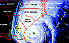
Check the radar presentation of the eye here........
http://www.srh.noaa.gov/ridge/ltx_N0Z_lp.shtml
Definitely getting it's act together...
http://www.srh.noaa.gov/ridge/ltx_N0Z_lp.shtml
Definitely getting it's act together...
0 likes

-
Three Blind Mice
- Tropical Storm
- Posts: 202
- Joined: Thu Jul 29, 2004 9:28 am
- Location: Wrightsville Beach, NC


Three Blind Mice wrote:sponger I concur with your thoughts. Seems this eye is organizing further west than anticipated. This may complicate things if it does turn because it leaves it over the gulf stream longer. Maybe JB wasn't so crazy with his 970 mb! Waitin' and watchin'
Maybe the BAMM and BAMD was right after all??????
0 likes
-
Brent
- S2K Supporter
- Posts: 38788
- Age: 37
- Joined: Sun May 16, 2004 10:30 pm
- Location: Tulsa Oklahoma
- Contact:
BULLETIN
TROPICAL STORM OPHELIA INTERMEDIATE ADVISORY NUMBER 29A
NWS TPC/NATIONAL HURRICANE CENTER MIAMI FL
2 PM EDT TUE SEP 13 2005
...OPHELIA WOBBLING SLOWLY NORTH-NORTHWESTWARD TOWARD THE
SOUTHEASTERN UNITED STATES...
...TROPICAL STORM-FORCE WINDS NEARING THE CAROLINA COASTS...
A HURRICANE WARNING REMAINS IN EFFECT FROM THE SOUTH SANTEE RIVER
SOUTH CAROLINA TO CAPE LOOKOUT NORTH CAROLINA. A HURRICANE WARNING
MEANS THAT HURRICANE CONDITIONS ARE EXPECTED IN THE WARNING AREA
WITHIN THE NEXT 24 HOURS.
A HURRICANE WATCH AND A TROPICAL STORM WARNING REMAIN IN EFFECT
NORTH OF CAPE LOOKOUT TO OREGON INLET...INCLUDING THE PAMLICO
SOUND...AND FROM SOUTH OF THE SOUTH SANTEE RIVER TO EDISTO BEACH
SOUTH CAROLINA.
A HURRICANE WATCH MEANS THAT HURRICANE CONDITIONS ARE POSSIBLE IN
THE WATCH AREA WITHIN THE NEXT 36 HR. A TROPICAL STORM WARNING MEANS
THAT TROPICAL STORM CONDITIONS ARE EXPECTED IN THE WARNING AREA
WITHIN THE NEXT 24 HOURS.
FOR STORM INFORMATION SPECIFIC TO YOUR AREA...INCLUDING POSSIBLE
INLAND WATCHES AND WARNINGS...PLEASE MONITOR PRODUCTS ISSUED
BY YOUR LOCAL WEATHER OFFICE.
AT 2 PM EDT...1800Z... DATA FROM AN AIR FORCE RESERVE UNIT
RECONNAISSANCE AIRCRAFT AND NOAA COASTAL DOPPLER RADARS INDICATE
THE CENTER OF TROPICAL STORM OPHELIA WAS LOCATED NEAR LATITUDE 32.5
NORTH... LONGITUDE 78.0 WEST OR ABOUT 120 MILES EAST-SOUTHEAST OF
CHARLESTON SOUTH CAROLINA AND ABOUT 125 MILES SOUTH OF WILMINGTON
NORTH CAROLINA.
OPHELIA IS MOVING SLOWLY TOWARD THE NORTH-NORTHWEST NEAR 4 MPH AND
THIS GENERAL MOTION IS FORECAST TO CONTINUE TODAY. A GRADUAL TURN
TOWARD THE NORTH IS EXPECTED TONIGHT OR ON WEDNESDAY. HOWEVER...
STEERING CURRENTS REMAIN WEAK...SO SOME ERRATIC MOTION WILL BE
POSSIBLE.
MAXIMUM SUSTAINED WINDS ARE NEAR 70 MPH WITH HIGHER GUSTS. SOME
SLOW STRENGTHENING IS FORECAST DURING THE NEXT 24 HOURS... AND
OPHELIA COULD BECOME A HURRICANE AGAIN LATER TODAY OR TONIGHT.
TROPICAL STORM FORCE WINDS EXTEND OUTWARD UP TO 160 MILES FROM THE
CENTER. OPHELIA'S STRONGEST WINDS ARE LOCATED RELATIVELY FAR FROM
THE CENTER...ROUGHLY 50 TO 60 MILES...AND THESE WINDS WILL REACH THE
COASTLINE WELL IN ADVANCE OF THE CENTER. DURING THE PAST HOUR...
NOAA BUOY 41004 LOCATED EAST-SOUTHEAST OF CHARLESTON REPORTED
SUSTAINED WINDS OF 49 MPH WITH A GUST TO 60 MPH...WHILE NOAA BUOY
41013 LOCATED SOUTH-SOUTHEAST OF CAPE FEAR REPORTED SUSTAINED WINDS
OF 45 MPH WITH A GUST TO 54 MPH.
THE MINIMUM CENTRAL PRESSURE RECENTLY REPORTED BY RECONNAISSANCE
AIRCRAFT HAS REMAINED STEADY AT 989 MB...29.21 INCHES.
STORM SURGE FLOODING OF 4 TO 6 FEET ABOVE NORMAL TIDE LEVELS...ALONG
WITH LARGE AND DANGEROUS BATTERING WAVES...ARE POSSIBLE IN AREAS OF
ONSHORE WINDS IN ASSOCIATION WITH OPHELIA. A STORM SURGE OF 6 TO
8 FEET IS POSSIBLE AT THE HEADS OF BAYS AND RIVERS.
OPHELIA IS EXPECTED TO PRODUCE TOTAL RAINFALL ACCUMULATIONS OF 6 TO
10 INCHES OVER FAR NORTHEASTERN SOUTH CAROLINA AND EASTERN NORTH
CAROLINA...WITH POSSIBLE ISOLATED MAXIMUM RAINFALL AMOUNTS OF 15
INCHES OVER EASTERN NORTH CAROLINA.
ISOLATED TORNADOES ARE POSSIBLE ALONG THE COASTAL AREAS OF NORTH
CAROLINA LATER TODAY AND TONIGHT.
REPEATING THE 2 PM EDT POSITION...32.5 N... 78.0 W. MOVEMENT
TOWARD...NORTH-NORTHWEST NEAR 4 MPH. MAXIMUM SUSTAINED
WINDS... 70 MPH. MINIMUM CENTRAL PRESSURE... 989 MB.
THE NEXT ADVISORY WILL BE ISSUED BY THE NATIONAL HURRICANE CENTER
AT 5 PM EDT.
FORECASTER STEWART
0 likes
#neversummer
-
seahawkjd
- S2K Supporter
- Posts: 632
- Joined: Wed Sep 10, 2003 4:12 pm
- Location: Morehead City, NC
- Contact:
on the satellite page at http://www.nhc.noaa.gov, there is a really nice tool on the loop sat shots that lets you superimpose things such as storm track and radar over the loop. If you look at the forcast points for Ophilia, to make its 12 hour point it looks like its going to have to head northeast. Do you think they'll change the forcast path more to the west soon?
0 likes
-
Three Blind Mice
- Tropical Storm
- Posts: 202
- Joined: Thu Jul 29, 2004 9:28 am
- Location: Wrightsville Beach, NC
they will not move that plot thats at havelock,nc.The early part of the track has shifted left but they just sharpen the turn to make that 36 hour plot.She is looking really good right now and if she sits over that gulfstream longer she might make it to 80mph or so just prior to landfall!Closest approach for me is 46 miles to my SSE so i will be on the weaker side!!!!
0 likes
-
GaryOBX
- Tropical Depression

- Posts: 90
- Joined: Wed Sep 03, 2003 2:33 pm
- Location: Outer Banks, NC
- Contact:
seahawkjd wrote:If you look at the forcast points for Ophilia, to make its 12 hour point it looks like its going to have to head northeast.
The +12HR position is 32.9N 78.1W
At 11AM, the location was 32.3N 78.0W
At 2PM, the location is 32.5 N... 78.0 W
So, by 11PM it needs to go 0.4N 0.1W, or NNW.
You're getting the dry-air confused with the circulation.
Last edited by GaryOBX on Tue Sep 13, 2005 1:06 pm, edited 2 times in total.
0 likes
-
Jevo

- S2K Supporter
- Posts: 1729
- Age: 48
- Joined: Tue Aug 03, 2004 8:45 pm
- Location: The Flemish Cap
- Contact:
ThunderMate wrote:i think it will go north of the NHC track right now because the trof which is coming from the midwest will be slowed down by the mountains which will allow the strom to move more north before Northeast....any thoughts?
Ive been doing this for a while and Ive never heard of any land masses having any impact on an upper level jet feature. If Im wrong please correct me....
DISCLAIMER: Most of my analysis is a combination between a magic 8 ball and voodoo... Please refer to Official Products for the most up to date information
0 likes
Disclaimer: 50% of the time I have no clue of what I am talking about. Chances are I am taking a less than educated guess that sounds good because 10 years ago I stole Mike Watkins book 'The Hurricane and its Impact'. For official information please direct yourself to the NHC and their cadre of weather geniuses.
Who is online
Users browsing this forum: No registered users and 689 guests