Tropical Storm Ophelia

Moderator: S2k Moderators

Message
Author
stormynorfolk
S2K Supporter
S2K Supporter
Posts: 23
Joined: Fri Sep 09, 2005 1:08 pm
Location: Norfolk, Virginia

#1321 Postby stormynorfolk » Mon Sep 12, 2005 5:31 pm

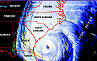
ThunderMate wrote:hey stromynorfolk im here on chesapeake and Va Beach line..yes its looking we might have a bonnie type system hitting us in about 23 days what do you think>? Don Slater said 60 mph winds are to be expected and could be higher depending on the track.....personally at this point im thinking Accuweather track is more likely than NHC track just because i don't see it turning that sharply...any thoughts?


I'd say 60-70+ mph gusts are certainly possible near the water (Ocean/Bay)... you're likely to see gusts to 50+ mph were you are, as being inland will cut down on the speed due to friction. but it's still enough to possibly knock-out power, and down some large tree limbs/newly planted trees.

Possibly like Isabel - wind-wise ... a strong nor-easter rain/flood-wise.

This would be based on the current track... any change in the forecasted track could cause this prediction to be drastically different.
Last edited by stormynorfolk on Mon Sep 12, 2005 5:48 pm, edited 1 time in total.
0 likes   

User avatar
webke
S2K Supporter
S2K Supporter
Posts: 290
Age: 69
Joined: Sun Sep 05, 2004 12:39 pm
Location: North Myrtle Beach SC

#1322 Postby webke » Mon Sep 12, 2005 5:44 pm

Jim Hughes wrote:
deltadog03 wrote:im still sorta suprised they didn't at least shift the track a little west... :roll:


Have to wonder about -removed- here. I would like to hear from the experts regarding how long a system has to be moving in a certain direction to establish it. Only the 12 hour track makes sense from what they are saying.

Since the 5pm Discussion yesterday

.3 N 1.4 W

During the past 12 hours

.5 N .7W

6 hrs.. .2 N .6 W

3 hrs. 0 N .1 W

Are they relying on the models being right? I hope not with their Ophelia track record. Maybe I am wrong about something here.


Jim


I have watched this all day and I would like to know just when is this turn suppose to begin. As far as I could tell it has not changed direction at all and I also do not see any changes in the outflow.
0 likes   

User avatar
Okibeach
Tropical Depression
Tropical Depression
Posts: 87
Joined: Mon Aug 30, 2004 11:12 pm
Location: Oak Island NC

#1323 Postby Okibeach » Mon Sep 12, 2005 6:08 pm

First real heavy band of rain just went through. Quite gusty all day as well. Will be an interesting couple of days ahead.
0 likes   

User avatar
WindRunner
Category 5
Category 5
Posts: 5806
Age: 34
Joined: Fri Jul 29, 2005 8:07 pm
Location: Warrenton, VA, but Albany, NY for school
Contact:

#1324 Postby WindRunner » Mon Sep 12, 2005 6:24 pm

Okibeach wrote:First real heavy band of rain just went through. Quite gusty all day as well. Will be an interesting couple of days ahead.


I was watching that on radar. Looked like fun.
0 likes   

User avatar
Okibeach
Tropical Depression
Tropical Depression
Posts: 87
Joined: Mon Aug 30, 2004 11:12 pm
Location: Oak Island NC

#1325 Postby Okibeach » Mon Sep 12, 2005 6:36 pm

WindRunner wrote:
Okibeach wrote:First real heavy band of rain just went through. Quite gusty all day as well. Will be an interesting couple of days ahead.


I was watching that on radar. Looked like fun.


Currently expecting 4-6 inches of rain here so lots more yet to come.
0 likes   

User avatar
MBismyPlayground
S2K Supporter
S2K Supporter
Posts: 765
Joined: Mon Sep 06, 2004 9:25 pm
Location: myrtle beach, sc
Contact:

#1326 Postby MBismyPlayground » Mon Sep 12, 2005 6:53 pm

We are getting our first batch of rain here in Myrtle as well. Plus the red glow.
0 likes   

tracyswfla
S2K Supporter
S2K Supporter
Posts: 792
Joined: Tue May 18, 2004 1:19 pm
Location: Rochester, NY

#1327 Postby tracyswfla » Mon Sep 12, 2005 7:01 pm

Tropical Storm Ophelia Intermediate Advisory Number 26a


Statement as of 8:00 PM EDT on September 12, 2005


...Outer rainbands reaching the coast as Ophelia continues slowly
northwestward...

a Tropical Storm Warning and a Hurricane Watch are in effect for
the southeast coast of the United States from north of Edisto Beach
South Carolina northeastward to Cape Lookout North Carolina.

A Tropical Storm Warning means that tropical storm conditions are
expected within the warning area within the next 24 hours.

A Hurricane Watch means that hurricane conditions are possible
within the watch area...generally within 36 hours.

Watches or warnings may have to be extended northward later tonight.

Interests elsewhere in the southeastern United States coastal region
should monitor the progress of Ophelia.

For storm information specific to your area...including possible
inland watches and warnings...please monitor products issued
by your local weather office.

At 8 PM EDT...0000z...the center of Tropical Storm Ophelia was
located near latitude 31.9 north... longitude 77.6 west or about
160 miles east-southeast of Charleston South Carolina and about 260
miles south-southwest of Cape Hatteras North Carolina.

Ophelia is moving toward the northwest near 4 mph and a gradual
turn toward the north is expected over the next 24 hours.

Maximum sustained winds are near 70 mph...with higher gusts.
Ophelia has the potential to restrengthen into a hurricane during
the next 24 hours.

Tropical storm force winds extend outward up to 160 miles from the
center. Outer rain bands are currently moving onshore within the
warning area.

Estimated minimum central pressure is 988 mb...29.18 inches.

Storm surge flooding of 4 to 6 feet above normal tide levels...along
with large and dangerous battering waves...are possible in areas of
onshore winds in association with Ophelia. A storm surge of up to
7 feet is possible at the heads of bays and rivers.

Ophelia is expected to produce rainfall amounts of 3 to 5 inches
with local amounts up to 8 inches across eastern portions of North
Carolina and the northern coast of South Carolina over the next 2
days.

Repeating the 8 PM EDT position...31.9 N... 77.6 W. Movement
toward...northwest near 4 mph. Maximum sustained winds... 70 mph.
Minimum central pressure... 988 mb.

The next advisory will be issued by the National
Hurricane Center at 11 PM EDT.

Forecaster Franklin
0 likes   

User avatar
Regit
Category 5
Category 5
Posts: 2341
Joined: Mon Sep 15, 2003 9:02 pm
Location: Myrtle Beach

#1328 Postby Regit » Mon Sep 12, 2005 7:06 pm

Over the last 6 hours the storm has gone from 31.8N 77.3W to 31.9N 77.6W. NHC says that's NW. Isn't that WNW?
0 likes   

User avatar
webke
S2K Supporter
S2K Supporter
Posts: 290
Age: 69
Joined: Sun Sep 05, 2004 12:39 pm
Location: North Myrtle Beach SC

#1329 Postby webke » Mon Sep 12, 2005 7:11 pm

The 1218z GFDL has shifted even further to the right. Is it following the lead of the GFS or am I not seeing what will turn this.

http://moe.met.fsu.edu/tcgengifs/
0 likes   

krisj
Category 1
Category 1
Posts: 271
Joined: Tue Sep 16, 2003 7:39 pm
Location: Mt. Pleasant, SC

#1330 Postby krisj » Mon Sep 12, 2005 7:15 pm

Sky was red here tonight too. Still not expecting much here although it is breezy.
0 likes   

seahawkjd
S2K Supporter
S2K Supporter
Posts: 632
Joined: Wed Sep 10, 2003 4:12 pm
Location: Morehead City, NC
Contact:

#1331 Postby seahawkjd » Mon Sep 12, 2005 7:24 pm

Just another knock at the weather channel's expense. I love the weather channel but they make it so easy sometimes. I was checking the forcast for Wednesday. Basically it says heavy rain / wind from the storm, but on the side of the 10 day forcast there's a little note for Wednesday that says "don't forget the sunblock"
0 likes   

User avatar
cycloneye
Admin
Admin
Posts: 145313
Age: 68
Joined: Thu Oct 10, 2002 10:54 am
Location: San Juan, Puerto Rico

#1332 Postby cycloneye » Mon Sep 12, 2005 7:50 pm

TPNT KGWC 122125
A. TROPICAL STORM OPHELIA (SIXTEEN)
B. 12/2031Z (82)
C. 31.8N/2
D. 77.7W/1
E. FIVE/GOES12
F. T3.0/3.5/W1.0/24HRS -12/1731Z-
G. IR/EIR/VIS/MSI

49A/ PBO PTLY XPSD LLCC/ANMTN. PER LATEST VIS...A SML BURST OF
CNVCTN HAS FORMED ON WRN SIDE OF PREV XPSD CNTR...THUS CNTR IS NOW
PRTLY COVRD. PER LAST 3HRS...SYS HAS ONLY MOVD ABT 10NM TO THE NW
OF PREV LOCATN.

AODT: T3.6 (CRVD BND)

LAURENTI


Air Force T Numbers.
0 likes   
Visit the Caribbean-Central America Weather Thread where you can find at first post web cams,radars
and observations from Caribbean basin members Click Here

User avatar
Tommedic
Tropical Storm
Tropical Storm
Posts: 180
Joined: Wed Oct 09, 2002 10:57 pm
Location: Cape Fear NC
Contact:

Charleston Radar

#1333 Postby Tommedic » Mon Sep 12, 2005 7:54 pm

Good picture from Charleston Radar. Makes you wonder where she will go.....

http://www.crh.noaa.gov/radar/loop/DS.p ... kclx.shtml
0 likes   

Adam T
Tropical Wave
Tropical Wave
Posts: 1
Joined: Thu Aug 25, 2005 10:05 am
Location: Charleston, SC

#1334 Postby Adam T » Mon Sep 12, 2005 7:59 pm

Was in Jacksonville last weekend. Things are starting to look similar here in Charleston. Waiting for that turn...

I've been lurking for a while...thought I'd put in my two cents :lol:
0 likes   

User avatar
wxman57
Moderator-Pro Met
Moderator-Pro Met
Posts: 22978
Age: 67
Joined: Sat Jun 21, 2003 8:06 pm
Location: Houston, TX (southwest)

#1335 Postby wxman57 » Mon Sep 12, 2005 7:59 pm

I added another image to my comparison of Ophelia after losing her core yesterday. It's 24 hours later and not only is Ophelia still without a core of convection, but the outer core of max winds has expanded. With no inflow into the center, it's going to be VERY hard to regenerate that core prior to landfall. In such storms that have entrained dry air, the 90% wind conversion from 700 mb just won't apply. Max winds out about 60-80 miles from the center are likely closer to 50-60 mph rather than the VERY generous 70 mph the NHC is indicating. So Ophelia has had 24 hours to regenerate a core and she only looks worse tonight. It's looking unlikely that Ophelia can gain much strength prior to landfall. Also, without a core of squalls, rainfall will be much less than with a "normal" TS. Here's the image I made:

<img src="http://myweb.cableone.net/nolasue/opheliacompare.gif">
0 likes   

User avatar
NCHurricane
Category 1
Category 1
Posts: 400
Age: 54
Joined: Sun Jul 24, 2005 2:50 pm
Location: Winterville, North Carolina, USA
Contact:

#1336 Postby NCHurricane » Mon Sep 12, 2005 8:07 pm

wxman57 wrote:I added another image to my comparison of Ophelia after losing her core yesterday. It's 24 hours later and not only is Ophelia still without a core of convection, but the outer core of max winds has expanded. With no inflow into the center, it's going to be VERY hard to regenerate that core prior to landfall. In such storms that have entrained dry air, the 90% wind conversion from 700 mb just won't apply. Max winds out about 60-80 miles from the center are likely closer to 50-60 mph rather than the VERY generous 70 mph the NHC is indicating. So Ophelia has had 24 hours to regenerate a core and she only looks worse tonight. It's looking unlikely that Ophelia can gain much strength prior to landfall. Also, without a core of squalls, rainfall will be much less than with a "normal" TS. Here's the image I made:


....Dumb question alert.......dumb question alert.....

The convection looks to be better around the large opening left by the absence of convection in the core. Could there be a way for that convection to totally surround the center and form a very large eye-like feature?
0 likes   

User avatar
millibar
Tropical Depression
Tropical Depression
Posts: 62
Joined: Tue Jul 22, 2003 7:11 pm
Location: Wilmington, NC

#1337 Postby millibar » Mon Sep 12, 2005 8:15 pm

Totally agree, wxman. With the collapse comes the "spreading out" of the windfield. Thus, I'm looking at (IMO) a longer period os TS force winds, but nothing approaching 65 knots.

Enjoy your posts, very educational. Thanks!

Chuck
0 likes   

User avatar
Regit
Category 5
Category 5
Posts: 2341
Joined: Mon Sep 15, 2003 9:02 pm
Location: Myrtle Beach

#1338 Postby Regit » Mon Sep 12, 2005 8:20 pm

I put this under the advisories thread but nobody reads that b/w advisories, so I'll put it here.

NHC said that at 2PM the center was 31.8N 77.3W and at 8PM it was 31.9N and 77.6W. Doesn't the mean she has moved WNW and not NW. Just wondering why it said NW. Also, looks like O has stalled in the latest radar and IR pics. Anyone else see this, or is the an illusion caused by the growing cloud cover around the center?
0 likes   

User avatar
Hurricanehink
S2K Supporter
S2K Supporter
Posts: 2040
Joined: Sun Nov 16, 2003 2:05 pm
Location: New Jersey

#1339 Postby Hurricanehink » Mon Sep 12, 2005 8:22 pm

Wow, it has a 200 mile wide eye! :lol:
This is pretty disorganized, and personally, I doubt it will regain hurricane strength.
0 likes   

superfly

#1340 Postby superfly » Mon Sep 12, 2005 8:26 pm

Well, I guess the TS icon actually resembles the storm for once.

Image

Image
0 likes   


Return to “2005”

Who is online

Users browsing this forum: No registered users and 0 guests