The Cdo has developed. With good outflow/banding. But no signs of a tight curving yet. In which shows that this will not likely to form a eye intill it can. I say a 3.0 or 45 knots.
I'v seen weak tropical storms look better then this...
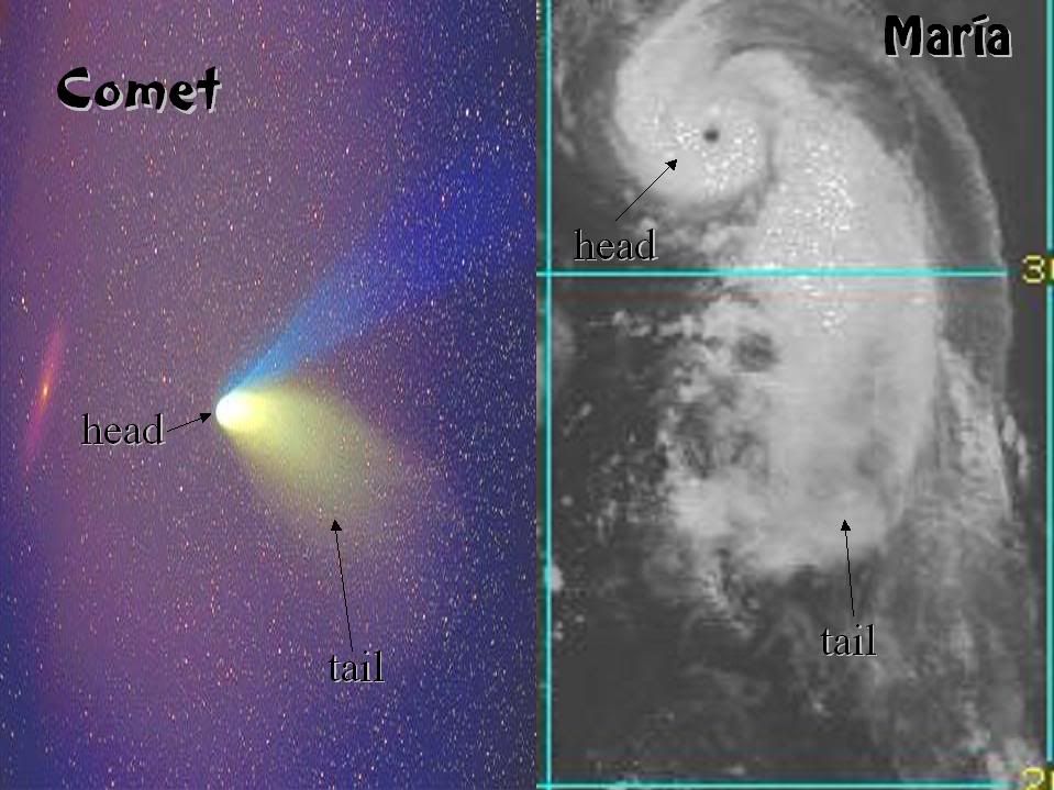
Tropical Storm Maria,Comments,Sat Pics,Models Thread
Moderator: S2k Moderators
Forum rules

The posts in this forum are NOT official forecasts and should not be used as such. They are just the opinion of the poster and may or may not be backed by sound meteorological data. They are NOT endorsed by any professional institution or STORM2K. For official information, please refer to products from the National Hurricane Center and National Weather Service.

-
Jim Hughes
- Category 3

- Posts: 825
- Joined: Sun Jul 24, 2005 1:52 pm
- Location: Martinsburg West Virginia
-
cycloneye

- Admin

- Posts: 148841
- Age: 69
- Joined: Thu Oct 10, 2002 10:54 am
- Location: San Juan, Puerto Rico
NATIONAL HURRICANE CENTER NORTH ATLANTIC OBJECTIVE AIDS FOR
HURRICANE MARIA (AL142005) ON 20050904 1200 UTC
...00 HRS... ...12 HRS... ...24 HRS... ...36 HRS...
050904 1200 050905 0000 050905 1200 050906 0000
LAT LON LAT LON LAT LON LAT LON
BAMD 28.3N 55.3W 30.0N 56.3W 31.8N 56.8W 33.3N 56.4W
BAMM 28.3N 55.3W 30.2N 56.2W 32.2N 56.8W 34.1N 56.4W
A98E 28.3N 55.3W 30.2N 55.9W 32.4N 55.7W 33.8N 55.8W
LBAR 28.3N 55.3W 30.2N 55.9W 32.2N 56.5W 34.1N 56.7W
SHIP 65KTS 70KTS 74KTS 78KTS
DSHP 65KTS 70KTS 74KTS 78KTS
...48 HRS... ...72 HRS... ...96 HRS... ..120 HRS...
050906 1200 050907 1200 050908 1200 050909 1200
LAT LON LAT LON LAT LON LAT LON
BAMD 34.3N 54.8W 35.7N 46.9W 38.7N 32.9W 43.6N 26.2W
BAMM 35.3N 55.3W 36.4N 49.1W 36.7N 37.8W 37.3N 28.4W
A98E 35.1N 53.9W 38.5N 45.8W 41.9N 34.4W 46.5N 24.3W
LBAR 36.0N 56.1W 38.9N 52.3W 40.9N 43.9W 40.1N 35.2W
SHIP 78KTS 75KTS 69KTS 60KTS
DSHP 78KTS 75KTS 69KTS 60KTS
...INITIAL CONDITIONS...
LATCUR = 28.3N LONCUR = 55.3W DIRCUR = 340DEG SPDCUR = 10KT
LATM12 = 26.5N LONM12 = 54.6W DIRM12 = 337DEG SPDM12 = 10KT
LATM24 = 24.6N LONM24 = 53.2W
WNDCUR = 65KT RMAXWD = 15NM WNDM12 = 60KT
CENPRS = 987MB OUTPRS = 1013MB OUTRAD = 200NM SDEPTH = D
RD34NE = 100NM RD34SE = 75NM RD34SW = 40NM RD34NW = 75NM
No changes from the 5 AM advisorie 75 mph at 11 AM.
0 likes
Visit the Caribbean-Central America Weather Thread where you can find at first post web cams,radars
and observations from Caribbean basin members Click Here
and observations from Caribbean basin members Click Here
-
cycloneye
- Admin
- Posts: 148841
- Age: 69
- Joined: Thu Oct 10, 2002 10:54 am
- Location: San Juan, Puerto Rico
TPNT KGWC 042356 COR
A. HURRICANE MARIA (FOURTEEN)
B. 04/2331Z (79)
C. 29.9N/0
D. 56.1W/2
E. FOUR/GOES12
F. T4.5/4.5/D1.5/24HRS -04/2331Z-
G. IR/EIR
13A/ PBO TGTLY CRVD BND/ANMTN. CNVCTN WRAPS 1.40 USING THE LOG10
SPIRAL GIVING A DT OF 4.5. FT IS BASED ON DT...MET AGREES...BUT PT
STILL YIELDS A 4.0. COR FOR DTG IN HEADER. COR SENT...04/2358Z.
AODT: T5.5 (CLR EYE)
LAURENTI
Air Force T Numbers for Maria.
0 likes
Visit the Caribbean-Central America Weather Thread where you can find at first post web cams,radars
and observations from Caribbean basin members Click Here
and observations from Caribbean basin members Click Here
-
WindRunner

- Category 5

- Posts: 5806
- Age: 35
- Joined: Fri Jul 29, 2005 8:07 pm
- Location: Warrenton, VA, but Albany, NY for school
- Contact:
Doesn't look like a whole lot more time to strengthen per 12Z models.
WHXX01 KWBC 051235
CHGHUR
DISCLAIMER...NUMERICAL MODELS ARE SUBJECT TO LARGE ERRORS.
PLEASE REFER TO TPC/NHC OFFICIAL FORECASTS FOR TROPICAL CYCLONES.
NATIONAL HURRICANE CENTER NORTH ATLANTIC OBJECTIVE AIDS FOR
HURRICANE MARIA (AL142005) ON 20050905 1200 UTC
...00 HRS... ...12 HRS... ...24 HRS... ...36 HRS...
050905 1200 050906 0000 050906 1200 050907 0000
LAT LON LAT LON LAT LON LAT LON
BAMD 31.4N 56.7W 32.6N 56.6W 33.4N 55.7W 34.2N 53.8W
BAMM 31.4N 56.7W 32.8N 56.6W 33.7N 56.3W 34.2N 55.6W
A98E 31.4N 56.7W 32.7N 56.3W 33.9N 55.0W 34.7N 53.8W
LBAR 31.4N 56.7W 32.7N 56.5W 34.0N 56.1W 35.5N 55.5W
SHIP 80KTS 82KTS 80KTS 74KTS
DSHP 80KTS 82KTS 80KTS 74KTS
...48 HRS... ...72 HRS... ...96 HRS... ..120 HRS...
050907 1200 050908 1200 050909 1200 050910 1200
LAT LON LAT LON LAT LON LAT LON
BAMD 35.5N 51.1W 40.4N 43.5W 44.5N 38.2W 47.0N 33.8W
BAMM 34.5N 54.1W 36.4N 45.6W 41.1N 34.5W 46.2N 28.5W
A98E 36.1N 51.5W 38.5N 46.8W 40.6N 39.8W 41.7N 19.6W
LBAR 36.7N 54.5W 39.3N 50.0W 39.9N 41.7W 39.2N 32.2W
SHIP 70KTS 62KTS 57KTS 50KTS
DSHP 70KTS 62KTS 57KTS 50KTS
...INITIAL CONDITIONS...
LATCUR = 31.4N LONCUR = 56.7W DIRCUR = 0DEG SPDCUR = 7KT
LATM12 = 30.1N LONM12 = 56.5W DIRM12 = 331DEG SPDM12 = 8KT
LATM24 = 28.5N LONM24 = 55.4W
WNDCUR = 80KT RMAXWD = 15NM WNDM12 = 75KT
CENPRS = 977MB OUTPRS = 1012MB OUTRAD = 150NM SDEPTH = D
RD34NE = 100NM RD34SE = 80NM RD34SW = 50NM RD34NW = 75NM
0 likes
-
cycloneye
- Admin
- Posts: 148841
- Age: 69
- Joined: Thu Oct 10, 2002 10:54 am
- Location: San Juan, Puerto Rico
HURRICANE MARIA (AL142005) ON 20050905 1800 UTC
...00 HRS... ...12 HRS... ...24 HRS... ...36 HRS...
050905 1800 050906 0600 050906 1800 050907 0600
LAT LON LAT LON LAT LON LAT LON
BAMD 32.2N 56.7W 33.4N 56.4W 34.4N 54.8W 35.3N 51.7W
BAMM 32.2N 56.7W 33.5N 56.7W 34.2N 56.2W 34.4N 54.5W
A98E 32.2N 56.7W 33.7N 56.3W 35.1N 54.6W 36.1N 52.8W
LBAR 32.2N 56.7W 33.3N 56.5W 34.5N 56.1W 35.7N 55.6W
SHIP 90KTS 90KTS 84KTS 76KTS
DSHP 90KTS 90KTS 84KTS 76KTS
...48 HRS... ...72 HRS... ...96 HRS... ..120 HRS...
050907 1800 050908 1800 050909 1800 050910 1800
LAT LON LAT LON LAT LON LAT LON
BAMD 37.5N 48.3W 42.5N 43.2W 44.1N 40.4W 44.7N 31.6W
BAMM 34.9N 51.1W 39.2N 42.1W 43.6N 36.3W 46.5N 31.5W
A98E 37.0N 49.5W 36.3N 36.2W 39.4N 24.3W 40.7N 20.5W
LBAR 36.7N 54.6W 38.7N 50.4W 40.4N 44.9W 40.5N 38.6W
SHIP 71KTS 63KTS 58KTS 52KTS
DSHP 71KTS 63KTS 58KTS 52KTS
...INITIAL CONDITIONS...
LATCUR = 32.2N LONCUR = 56.7W DIRCUR = 0DEG SPDCUR = 8KT
LATM12 = 30.9N LONM12 = 56.8W DIRM12 = 353DEG SPDM12 = 7KT
LATM24 = 29.5N LONM24 = 55.9W
WNDCUR = 90KT RMAXWD = 15NM WNDM12 = 80KT
CENPRS = 970MB OUTPRS = 1012MB OUTRAD = 150NM SDEPTH = D
RD34NE = 100NM RD34SE = 100NM RD34SW = 60NM RD34NW = 80NM
Floydbuster did you looked at this before you posted?
0 likes
Visit the Caribbean-Central America Weather Thread where you can find at first post web cams,radars
and observations from Caribbean basin members Click Here
and observations from Caribbean basin members Click Here
-
ChaserUK

- Category 2

- Posts: 630
- Joined: Thu Aug 28, 2003 4:10 pm
- Location: Jersey, Channel Islands
- Contact:
not entirely convinced that Maria will not affect the UK in some form or another next week. Some models shove her up near Greenland as a large extra-tropical system but I don't know. I can hear the sea splashing against the sea wall 10 yards from my house right now.
Can't help but wonder what could happen with a big extra-tropical hitting this area at high tide.
Can't help but wonder what could happen with a big extra-tropical hitting this area at high tide.
0 likes


-
Matt-hurricanewatcher
-
cycloneye
- Admin
- Posts: 148841
- Age: 69
- Joined: Thu Oct 10, 2002 10:54 am
- Location: San Juan, Puerto Rico
TPNT KGWC 060005
A. HURRICANE MARIA (FOURTEEN)
B. 05/2331Z (79)
C. 32.5N/0
D. 56.6W/7
E. TWO/GOES12
F. T5.0/5.0/D0.5/24HRS -05/2331Z-
G. IR/EIR
01A/ PBO 17NM RND EYE/ANMTN. OW EYE IS SURROUNDED BY A 39NM
WIDE LG RING GIVING AN EYE NBR OF 5.0 WITH ZERO EYE ADJ...FOR A
CF/DT OF 5.0. FT IS BASED ON DT...BOTH MET AND PT AGREE.
AODT: T5.7 (CLR EYE)
LAURENTI
Air Force T Numbers.
0 likes
Visit the Caribbean-Central America Weather Thread where you can find at first post web cams,radars
and observations from Caribbean basin members Click Here
and observations from Caribbean basin members Click Here
-
cycloneye
- Admin
- Posts: 148841
- Age: 69
- Joined: Thu Oct 10, 2002 10:54 am
- Location: San Juan, Puerto Rico
NATIONAL HURRICANE CENTER NORTH ATLANTIC OBJECTIVE AIDS FOR
HURRICANE MARIA (AL142005) ON 20050906 0000 UTC
...00 HRS... ...12 HRS... ...24 HRS... ...36 HRS...
050906 0000 050906 1200 050907 0000 050907 1200
LAT LON LAT LON LAT LON LAT LON
BAMD 32.7N 56.6W 33.7N 55.7W 34.6N 53.2W 36.0N 49.7W
BAMM 32.7N 56.6W 34.0N 56.1W 34.9N 54.8W 35.5N 52.5W
A98E 32.7N 56.6W 33.8N 56.0W 35.3N 54.2W 36.8N 51.3W
LBAR 32.7N 56.6W 33.7N 56.0W 34.9N 55.5W 35.9N 54.6W
SHIP 95KTS 92KTS 83KTS 76KTS
DSHP 95KTS 92KTS 83KTS 76KTS
...48 HRS... ...72 HRS... ...96 HRS... ..120 HRS...
050908 0000 050909 0000 050910 0000 050911 0000
LAT LON LAT LON LAT LON LAT LON
BAMD 38.9N 45.9W 43.7N 41.3W 44.4N 37.7W 46.1N 27.7W
BAMM 36.4N 48.8W 40.4N 39.3W 44.6N 33.4W 47.9N 27.1W
A98E 38.8N 47.5W 44.3N 36.2W 49.7N 26.0W 63.2N 20.6W
LBAR 37.0N 53.1W 39.1N 47.8W 40.0N 41.6W 39.6N 34.9W
SHIP 70KTS 60KTS 53KTS 45KTS
DSHP 70KTS 60KTS 53KTS 45KTS
...INITIAL CONDITIONS...
LATCUR = 32.7N LONCUR = 56.6W DIRCUR = 10DEG SPDCUR = 6KT
LATM12 = 31.4N LONM12 = 56.7W DIRM12 = 4DEG SPDM12 = 7KT
LATM24 = 30.1N LONM24 = 56.5W
WNDCUR = 95KT RMAXWD = 15NM WNDM12 = 85KT
CENPRS = 965MB OUTPRS = 1012MB OUTRAD = 150NM SDEPTH = D
RD34NE = 100NM RD34SE = 100NM RD34SW = 60NM RD34NW = 80NM
110 mph.
0 likes
Visit the Caribbean-Central America Weather Thread where you can find at first post web cams,radars
and observations from Caribbean basin members Click Here
and observations from Caribbean basin members Click Here


Who is online
Users browsing this forum: Hammy and 106 guests