Invest 92L,Comments,Sat Pics,Models Thread
Moderator: S2k Moderators
Forum rules

The posts in this forum are NOT official forecasts and should not be used as such. They are just the opinion of the poster and may or may not be backed by sound meteorological data. They are NOT endorsed by any professional institution or STORM2K. For official information, please refer to products from the National Hurricane Center and National Weather Service.
-
BensonTCwatcher

- Category 5

- Posts: 1050
- Joined: Sat Aug 28, 2004 10:11 pm
- Location: Southport NC
I am not going with any of the models until they use the same circ center twice in a row at least  I think the deep tropic models overall may be better guidance at this point, given the location. We could see a re-formation one or more times here in the next 12 hrs. Somethings cooking alright, but I am not jumping on the cat 5 train just yet...
Last edited by BensonTCwatcher on Thu Sep 01, 2005 3:13 pm, edited 1 time in total.
0 likes

-
cycloneye

- Admin

- Posts: 148842
- Age: 69
- Joined: Thu Oct 10, 2002 10:54 am
- Location: San Juan, Puerto Rico
LOOKING AHEAD...WE ARE KEEPING AND EYE ON AN AREA OF DISTURBED
WEATHER ASSOCIATED WITH A STRONG TROPICAL WAVE THAT IS LOCATED
MIDWAY BETWEEN AFRICA AND THE LESSER ANTILLES. THIS SYSTEM IS WELL
ORGANIZED AND HAS THE POTENTIAL TO BECOME A TROPICAL DEPRESSION
DURING THE NEXT DAY OR TWO. COMPUTER MODELS FORECAST POSSIBLE
INTENSIFICATION OF THIS SYSTEM WHILE MOVING TO THE WEST NORTHWEST
OVER THE WARM TROPICAL ATLANTIC.
The above from the AFD NWS San Juan.
Already they are talking about the system.
0 likes
Visit the Caribbean-Central America Weather Thread where you can find at first post web cams,radars
and observations from Caribbean basin members Click Here
and observations from Caribbean basin members Click Here

-
PuertoRicoLibre
- Tropical Depression

- Posts: 68
- Joined: Thu Sep 04, 2003 2:38 pm
-
Canelaw99

- S2K Supporter

- Posts: 2128
- Age: 49
- Joined: Tue Aug 31, 2004 8:27 am
- Location: Homestead, FL
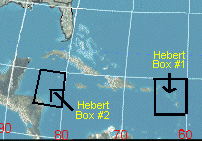
clfenwi wrote:Box #1 is defined by the points 20N/60W, 15N/60W, 15N/65W, and 20N/65W.
Box #2 is defined by the points 20N/80W, 15N/80W. 15N/85W, and 20N/85W.
See http://hurricanecity.com/images/hebertbox.gif for visual reference.
Thank you!
0 likes
-
aquaholic901
- Tropical Low

- Posts: 24
- Joined: Thu Aug 25, 2005 7:51 am
- Location: Tampa & Marathon, FL
Fego wrote:What is a herbert box?. Is an important climo fact or a myth?
Interesting, I was wondering as well:
http://www.hurricanecity.com/hebertbox.htm
0 likes
-
Andrew92

- S2K Supporter
- Posts: 3247
- Age: 42
- Joined: Mon Jun 16, 2003 12:35 am
- Location: Phoenix, Arizona
Scorpion wrote:Looking good. Would be nice to have 2 Cat 5's in one month, just for the record.
Are you kidding? Let me inform you, Katrina was NOT the C5 she had been when she made landfall....she was a C4 in the delta, and a C3 in Mississippi. Another C5 would be COOL in your opinion? I think we've had enough records set this season, don't you?
And right now, I'm not sold on 92L becoming a C5. But I do think it develops further over time.
-Andrew92
0 likes
-
BensonTCwatcher
- Category 5
- Posts: 1050
- Joined: Sat Aug 28, 2004 10:11 pm
- Location: Southport NC
Yeah... The NRL site gets more frequent passes than for the NOAA QS.
http://www.nrlmry.navy.mil/tc_pages/tc_home.html
Go to 92, then mouse over Scatt ( upper right) and click on wind barbs.
Lotta energy
http://www.nrlmry.navy.mil/tc_pages/tc_home.html
Go to 92, then mouse over Scatt ( upper right) and click on wind barbs.
Lotta energy
0 likes

92L does not look as though it will follow TD14 east of Bermuda.
Since it will be passing over warmer water I suspect it will start picking up convection again even though the convection is a little sparse now.
Hard to believe it won't gain some latitude if it spins up.
The models that have it diving into South America must be keeping it as a weak system.
The big islands look like they could be on the strong side of the storm so the UKMET is probably the best compromise track.
What is JB saying about this one?
0 likes
-
BensonTCwatcher
- Category 5
- Posts: 1050
- Joined: Sat Aug 28, 2004 10:11 pm
- Location: Southport NC
Also,
This loop is updated more frequently. Looks like it's going from blobbed to banded....to use technical terms of course
http://www.weather.com/maps/maptype/satelliteworld/atlanticoceansatellite_large_animated.html
This loop is updated more frequently. Looks like it's going from blobbed to banded....to use technical terms of course
http://www.weather.com/maps/maptype/satelliteworld/atlanticoceansatellite_large_animated.html
0 likes
-
Fego

- S2K Supporter
- Posts: 767
- Age: 65
- Joined: Sun Apr 18, 2004 7:58 pm
- Location: San Juan, Puerto Rico
- Contact:
Puertorrican Herbert Box
Interesting. Well, here in Puerto Rico we also have our Herbet Box: Guadalupe island. If a hurricane or storm pass over or very close to Guadalupe, chances are that we will be hit.
0 likes
Go Giants! Go Niners! Go Warriors!
-
cycloneye
- Admin
- Posts: 148842
- Age: 69
- Joined: Thu Oct 10, 2002 10:54 am
- Location: San Juan, Puerto Rico
Re: Puertorrican Herbert Box
Fego wrote:Interesting. Well, here in Puerto Rico we also have our Herbet Box: Guadalupe island. If a hurricane or storm pass over or very close to Guadalupe, chances are that we will be hit.
Yes that is right.And the 12z UKMET has that box as the track moving it close to Guadeloupe.
0 likes
Visit the Caribbean-Central America Weather Thread where you can find at first post web cams,radars
and observations from Caribbean basin members Click Here
and observations from Caribbean basin members Click Here
-
jabber

- Category 2

- Posts: 688
- Joined: Mon Mar 24, 2003 5:36 pm
- Location: Raleigh, NC (former Boynton Beach, Fl)
Nimbus wrote:92L does not look as though it will follow TD14 east of Bermuda.
Since it will be passing over warmer water I suspect it will start picking up convection again even though the convection is a little sparse now.
Hard to believe it won't gain some latitude if it spins up.
The models that have it diving into South America must be keeping it as a weak system.
The big islands look like they could be on the strong side of the storm so the UKMET is probably the best compromise track.
What is JB saying about this one?
JB is saying that this will be a player for the US, not sure yet Southeast or Gulf.
0 likes
-
PuertoRicoLibre
- Tropical Depression
- Posts: 68
- Joined: Thu Sep 04, 2003 2:38 pm
Re: Puertorrican Herbert Box
cycloneye wrote:Fego wrote:Interesting. Well, here in Puerto Rico we also have our Herbet Box: Guadalupe island. If a hurricane or storm pass over or very close to Guadalupe, chances are that we will be hit.
Yes that is right.And the 12z UKMET has that box as the track moving it close to Guadeloupe.
Close, as in right on top of Guadeloupe close.
0 likes
-
BensonTCwatcher
- Category 5
- Posts: 1050
- Joined: Sat Aug 28, 2004 10:11 pm
- Location: Southport NC
-
cycloneye
- Admin
- Posts: 148842
- Age: 69
- Joined: Thu Oct 10, 2002 10:54 am
- Location: San Juan, Puerto Rico
TWOAT
TROPICAL WEATHER OUTLOOK
NWS TPC/NATIONAL HURRICANE CENTER MIAMI FL
530 PM EDT THU SEP 1 2005
FOR THE NORTH ATLANTIC...CARIBBEAN SEA AND THE GULF OF MEXICO...
THE NATIONAL HURRICANE CENTER IS ISSUING ADVISORIES ON TROPICAL
DEPRESSION LEE...CENTERED ABOUT 775 MILES EAST OF BERMUDA...AND ON
TROPICAL DEPRESSION FOURTEEN...CENTERED ABOUT 1085 MILES EAST OF
THE NORTHERN LEEWARD ISLANDS.
A TROPICAL WAVE CENTERED MIDWAY BETWEEN AFRICA AND THE LESSER
ANTILLES REMAINS WELL ORGANIZED. ATMOSPHERIC CONDITIONS APPEAR
FAVORABLE FOR FURTHER DEVELOPMENT...AND THIS SYSTEM HAS THE
POTENTIAL TO BECOME A TROPICAL DEPRESSION AT ANY TIME DURING THE
NEXT DAY OR TWO AS IT MOVES WESTWARD.
ELSEWHERE...TROPICAL STORM FORMATION IS NOT EXPECTED THROUGH FRIDAY.
PUBLIC ADVISORIES ON TROPICAL DEPRESSION FOURTEEN ARE ISSUED UNDER
WMO HEADER WTNT34 AND UNDER AWIPS HEADER MIATCPAT4 AND
FORECAST/ADVISORIES ARE ISSUED UNDER WMO HEADER WTNT24 AND UNDER
AWIPS HEADER MIATCMAT4.
FORECASTER KNABB
5:30 PM TWO
0 likes
Visit the Caribbean-Central America Weather Thread where you can find at first post web cams,radars
and observations from Caribbean basin members Click Here
and observations from Caribbean basin members Click Here


Who is online
Users browsing this forum: No registered users and 176 guests