Invest 92L,Comments,Sat Pics,Models Thread
Moderator: S2k Moderators
Forum rules

The posts in this forum are NOT official forecasts and should not be used as such. They are just the opinion of the poster and may or may not be backed by sound meteorological data. They are NOT endorsed by any professional institution or STORM2K. For official information, please refer to products from the National Hurricane Center and National Weather Service.

-
MiamiensisWx

-
MiamiensisWx
-
cycloneye

- Admin

- Posts: 148842
- Age: 69
- Joined: Thu Oct 10, 2002 10:54 am
- Location: San Juan, Puerto Rico

12z UKMET.It plows into the Leeward islands as a Hurricane.
0 likes
Visit the Caribbean-Central America Weather Thread where you can find at first post web cams,radars
and observations from Caribbean basin members Click Here
and observations from Caribbean basin members Click Here
-
Canelaw99

- S2K Supporter

- Posts: 2128
- Age: 49
- Joined: Tue Aug 31, 2004 8:27 am
- Location: Homestead, FL
^^ I don't like that one AT ALL!
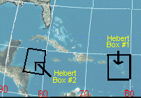
EDIT: Can someone remind me/us of the location of the Herbert box? (I think there are 2, so both would be fine)......
EDIT: Can someone remind me/us of the location of the Herbert box? (I think there are 2, so both would be fine)......
Last edited by Canelaw99 on Thu Sep 01, 2005 2:50 pm, edited 1 time in total.
0 likes
-
BensonTCwatcher

- Category 5

- Posts: 1050
- Joined: Sat Aug 28, 2004 10:11 pm
- Location: Southport NC
Not too hard to figure though considering it may already be a TS. i.e. the 45 and the one 50+ knot flag I posted before.
If it really is spooling up that quickly and not just a burst from a T-strom it coudl mean that it will gian height faster and may track further north away from the islands. Perhaps that is wishful thinking, but it is still too soon to tell. I think we will see an upgrade to TD next go-round
If it really is spooling up that quickly and not just a burst from a T-strom it coudl mean that it will gian height faster and may track further north away from the islands. Perhaps that is wishful thinking, but it is still too soon to tell. I think we will see an upgrade to TD next go-round
0 likes
-
Brent
- S2K Supporter
- Posts: 38668
- Age: 37
- Joined: Sun May 16, 2004 10:30 pm
- Location: Tulsa Oklahoma
- Contact:
BensonTCwatcher wrote:Not too hard to figure though considering it may already be a TS. i.e. the 45 and the one 50+ knot flag I posted before.
If it really is spooling up that quickly and not just a burst from a T-strom it coudl mean that it will gian height faster and may track further north away from the islands. Perhaps that is wishful thinking, but it is still too soon to tell. I think we will see an upgrade to TD next go-round
I'm surprised it's not already a TD...
0 likes
#neversummer


-
BensonTCwatcher
- Category 5
- Posts: 1050
- Joined: Sat Aug 28, 2004 10:11 pm
- Location: Southport NC
-
cycloneye
- Admin
- Posts: 148842
- Age: 69
- Joined: Thu Oct 10, 2002 10:54 am
- Location: San Juan, Puerto Rico
When you see a pretty good consensus of the global models you have to pay more definite attention.
0 likes
Visit the Caribbean-Central America Weather Thread where you can find at first post web cams,radars
and observations from Caribbean basin members Click Here
and observations from Caribbean basin members Click Here
http://www.atmos.washington.edu/~ovens/ ... nhanced+12
Am I the only not impressed with this system, it looked a lot better earlier this morning and its really elongated N to S.
Lets wait and see before we start talking Cat 5 on a invest...
Am I the only not impressed with this system, it looked a lot better earlier this morning and its really elongated N to S.
Lets wait and see before we start talking Cat 5 on a invest...
0 likes

Canelaw99 wrote:^^ I don't like that one AT ALL!
EDIT: Can someone remind me/us of the location of the Herbert box? (I think there are 2, so both would be fine)......
Box #1 is defined by the points 20N/60W, 15N/60W, 15N/65W, and 20N/65W.
Box #2 is defined by the points 20N/80W, 15N/80W. 15N/85W, and 20N/85W.
See http://hurricanecity.com/images/hebertbox.gif for visual reference.
0 likes
-
Scorpion
-
P.K.

- Professional-Met

- Posts: 5149
- Joined: Thu Sep 23, 2004 5:57 pm
- Location: Watford, England
- Contact:
cycloneye wrote:12z UKMET.It plows into the Leeward islands as a Hurricane.
Here is the actual model output, not good:
WTNT80 EGRR 011743
MET OFFICE TROPICAL CYCLONE GUIDANCE FOR NORTH-EAST PACIFIC
AND ATLANTIC
GLOBAL MODEL DATA TIME 12UTC 01.09.2005
TROPICAL STORM ANALYSED IN THE MODEL AT POSITION : 8.0N 29.6W
VERIFYING TIME POSITION STRENGTH TENDENCY
-------------- -------- -------- --------
12UTC 01.09.2005 8.0N 29.6W WEAK
00UTC 02.09.2005 8.1N 33.1W WEAK INTENSIFYING SLIGHTLY
12UTC 02.09.2005 8.6N 35.0W MODERATE INTENSIFYING SLIGHTLY
00UTC 03.09.2005 9.5N 36.6W MODERATE LITTLE CHANGE
12UTC 03.09.2005 10.5N 38.8W MODERATE LITTLE CHANGE
00UTC 04.09.2005 11.4N 41.4W MODERATE WEAKENING SLIGHTLY
12UTC 04.09.2005 12.3N 44.1W MODERATE LITTLE CHANGE
00UTC 05.09.2005 13.1N 46.9W MODERATE LITTLE CHANGE
12UTC 05.09.2005 13.8N 49.8W MODERATE INTENSIFYING SLIGHTLY
00UTC 06.09.2005 14.4N 53.0W MODERATE INTENSIFYING SLIGHTLY
12UTC 06.09.2005 15.2N 56.0W STRONG INTENSIFYING SLIGHTLY
00UTC 07.09.2005 15.9N 59.3W STRONG INTENSIFYING SLIGHTLY
12UTC 07.09.2005 16.5N 62.0W STRONG INTENSIFYING SLIGHTLY
THIS INFORMATION IS PROVIDED AS GUIDANCE FOR TROPICAL CYCLONE RSMCS. IT REQUIRES INTERPRETATION BY TROPICAL CYCLONE SPECIALISTS AND SHOULD NOT BE CONSIDERED AS A FINAL PRODUCT
MET OFFICE, EXETER, UK
TOO 011743
0 likes
Who is online
Users browsing this forum: No registered users and 165 guests