
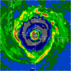
24/0615 UTC 23.5N 76.0W T2.5/2.5 12
Dvorak Technique says so!
Tropical Storm Katrina?
Moderator: S2k Moderators
Forum rules

The posts in this forum are NOT official forecasts and should not be used as such. They are just the opinion of the poster and may or may not be backed by sound meteorological data. They are NOT endorsed by any professional institution or STORM2K. For official information, please refer to products from the National Hurricane Center and National Weather Service.
Tropical Storm Katrina?
0 likes
-
Matt-hurricanewatcher
Ob #19: 06:38:30Z; 23.3°N 74.9°W; PA: 2510 ft; D-Value: 36 ft; Wind: S (182°) @ 46 mph; Temp: 63°F; Dewpt: 63°F; Max Wind: 50 mph; Radar Altitude: 2615 ft
Ob #20: 06:39:00Z; 23.4°N 74.9°W; PA: 2520 ft; D-Value: 36 ft; Wind: S (186°) @ 48 mph; Temp: 63°F; Dewpt: 63°F; Max Wind: 50 mph; Radar Altitude: 2625 ft
WOW, what a difference two minutes make! KATRINA!
Ob #20: 06:39:00Z; 23.4°N 74.9°W; PA: 2520 ft; D-Value: 36 ft; Wind: S (186°) @ 48 mph; Temp: 63°F; Dewpt: 63°F; Max Wind: 50 mph; Radar Altitude: 2625 ft
WOW, what a difference two minutes make! KATRINA!
0 likes
-
Matt-hurricanewatcher

Getting Interesting, the sooner she gets organized the faster she can get ramped up... I agree that this should be upgraded at the 5am as long as sat images and dvorack continue to show improvement and stabilized convection.
Should be an interesting day tomorrow, also considering i have to go up on the second story to put my weather station back up after its cleaning. yikes! lol
-Eric
Should be an interesting day tomorrow, also considering i have to go up on the second story to put my weather station back up after its cleaning.
-Eric
Last edited by ericinmia on Wed Aug 24, 2005 1:52 am, edited 1 time in total.
0 likes
-
gkrangers


-
SouthFloridawx

- S2K Supporter

- Posts: 8346
- Age: 47
- Joined: Tue Jul 26, 2005 1:16 am
- Location: Sarasota, FL
- Contact:
-
JamesFromMaine2

- Category 4

- Posts: 989
- Joined: Tue Jul 19, 2005 1:38 am
- Location: Portland Maine USA
- Contact:
TSmith274 wrote:Is it just me, or is she strenghthening a little faster than expected? (of course pending NHC confirmation)
Heres what the NHC said at 2am:
MAXIMUM SUSTAINED WINDS ARE NEAR 35 MPH... 55 KM/HR... WITH HIGHER
GUSTS. SOME STRENGTHENING IS FORECAST DURING THE NEXT 24 HOURS...
AND THE DEPRESSION COULD BECOME A TROPICAL STORM ON WEDNESDAY. AN
AIR FORCE RESERVE HURRICANE HUNTER IS CURRENTLY ENROUTE TO
INVESTIGATE THE DEPRESSION.
and today is wednesday so I don't know it could be developing a little faster then they thought but its really hard to say!
0 likes
-
SouthFloridawx
- S2K Supporter
- Posts: 8346
- Age: 47
- Joined: Tue Jul 26, 2005 1:16 am
- Location: Sarasota, FL
- Contact:
JamesFromMaine2 wrote:TSmith274 wrote:Is it just me, or is she strenghthening a little faster than expected? (of course pending NHC confirmation)
Heres what the NHC said at 2am:
MAXIMUM SUSTAINED WINDS ARE NEAR 35 MPH... 55 KM/HR... WITH HIGHER
GUSTS. SOME STRENGTHENING IS FORECAST DURING THE NEXT 24 HOURS...
AND THE DEPRESSION COULD BECOME A TROPICAL STORM ON WEDNESDAY. AN
AIR FORCE RESERVE HURRICANE HUNTER IS CURRENTLY ENROUTE TO
INVESTIGATE THE DEPRESSION.
and today is wednesday so I don't know it could be developing a little faster then they thought but its really hard to say!
to answer your question yes....
if they have found winds in the middle to upper 40 MPH then it would be faster than expected... this is the 11 PM intensity forcast issued by the NHC.

0 likes
Yeah, I know it's been a while since I have posted on here. Anyway, Zack, I think the answer to your question is yes.
The 0615 UTC image is out and shows deep convection wrapping over Exuma where the center is fixed. Looks like the mid-to-upper level low is getting further away from TD 12's surface circulation. This is allowing for divergence aloft over the center from the east that has been so condusive for explosive convection on the eastern side for most of yesterday and last night. There is still going to be some hindrance on the system's west side, but signs are that the ULL is weakening and pushing WSW.
The 0615 UTC image is out and shows deep convection wrapping over Exuma where the center is fixed. Looks like the mid-to-upper level low is getting further away from TD 12's surface circulation. This is allowing for divergence aloft over the center from the east that has been so condusive for explosive convection on the eastern side for most of yesterday and last night. There is still going to be some hindrance on the system's west side, but signs are that the ULL is weakening and pushing WSW.
0 likes
-
SouthFloridawx
- S2K Supporter
- Posts: 8346
- Age: 47
- Joined: Tue Jul 26, 2005 1:16 am
- Location: Sarasota, FL
- Contact:
-
SouthFloridawx
- S2K Supporter
- Posts: 8346
- Age: 47
- Joined: Tue Jul 26, 2005 1:16 am
- Location: Sarasota, FL
- Contact:
Who is online
Users browsing this forum: No registered users and 109 guests