SIO: GEZANI - Post-Tropical

Moderator: S2k Moderators

Message
Author
User avatar
cycloneye
Admin
Admin
Posts: 149110
Age: 69
Joined: Thu Oct 10, 2002 10:54 am
Location: San Juan, Puerto Rico

Re: SIO: GEZANI - Severe Tropical Storm

#61 Postby cycloneye » Thu Feb 12, 2026 5:05 am

-------------------------------------------------

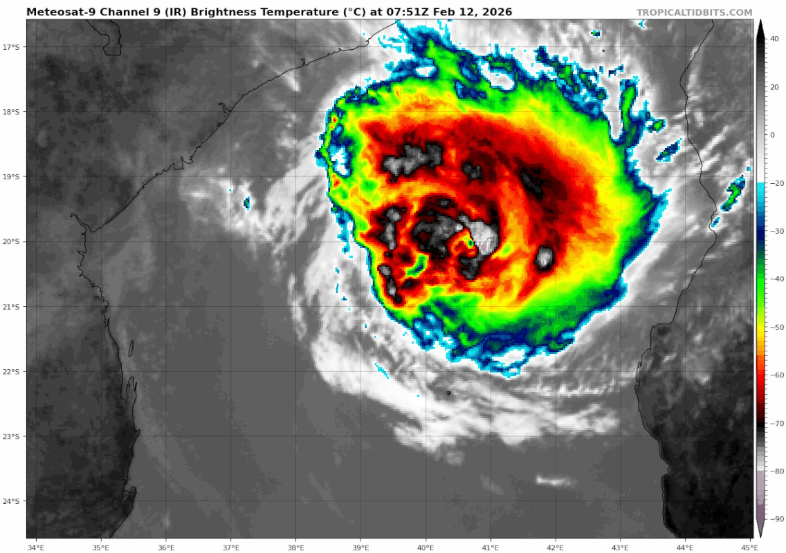
SEVERE TROPICAL STORM GEZANI


Estimated maximum wind speeds (averaged over 10 minutes) at sea: 100 km/h.

Estimated maximum gusts at sea: 150 km/h.

Estimated pressure at the center: 990 hPa.

Position on February 12 at 10 a.m. local time: 19.8 South / 41.0 East.

Distance from the coast of Réunion: 1490 km to the WEST sector

Distance from Mayotte: 900 km to the SOUTH-SOUTHWEST sector

Movement: WEST-SOUTH-WEST, at 19 km/h.

System information:

- GEZANI continues to move away from Madagascar in a west-southwest direction while intensifying. It is at the stage of a severe tropical storm.

- Further intensification is expected in the coming days as it crosses the Channel. It could reach tropical cyclone strength by tonight on a track gradually curving southwest. Intensification to intense tropical cyclone strength is possible Friday evening before approaching the coast of Mozambique.

- A very close passage to the Mozambican coast or even a temporary landing is envisaged between Friday night to Saturday and Saturday morning at the level of the province of Inhambane, but the distance of passage remains to be specified.
0 likes   
Visit the Caribbean-Central America Weather Thread where you can find at first post web cams,radars
and observations from Caribbean basin members Click Here

User avatar
cycloneye
Admin
Admin
Posts: 149110
Age: 69
Joined: Thu Oct 10, 2002 10:54 am
Location: San Juan, Puerto Rico

Re: SIO: GEZANI - Severe Tropical Storm

#62 Postby cycloneye » Thu Feb 12, 2026 5:46 am

The eye is back.

Image
2 likes   
Visit the Caribbean-Central America Weather Thread where you can find at first post web cams,radars
and observations from Caribbean basin members Click Here

User avatar
cycloneye
Admin
Admin
Posts: 149110
Age: 69
Joined: Thu Oct 10, 2002 10:54 am
Location: San Juan, Puerto Rico

Re: SIO: GEZANI - Tropical Cyclone

#63 Postby cycloneye » Thu Feb 12, 2026 7:40 am

Tropical Cyclone Gezani


Estimated maximum wind speeds (averaged over 10 minutes) at sea: 120 km/h.

Estimated maximum gusts at sea: 165 km/h.

Estimated pressure at the center: 983 hPa.

Position on February 12 at 4 p.m. local time: 20.3 South / 39.9 East.

Distance from the coast of Réunion: 1595 km to the WEST sector

Distance from Mayotte: 1000 km to the SOUTH-WEST sector

Movement: WEST-SOUTH-WEST, at 20 km/h.

System information:

- GEZANI continues to approach the Mozambican coast in a west-southwest direction, intensifying as it moves towards the tropical cyclone stage.

- Further intensification is expected over the next 36 hours as it crosses the Channel. It will remain a tropical cyclone on a track gradually curving southwestward. Intensification to an intense tropical cyclone is possible Friday evening before approaching the coast of Mozambique.

- A very close passage to the Mozambican coast or even a temporary landing is envisaged between Friday night to Saturday and Saturday morning at the level of the province of Inhambane, but the distance of passage remains to be specified.
0 likes   
Visit the Caribbean-Central America Weather Thread where you can find at first post web cams,radars
and observations from Caribbean basin members Click Here

User avatar
sasha_B
Category 1
Category 1
Posts: 318
Age: 25
Joined: Sun Jun 30, 2024 4:32 pm
Location: Charleston, SC

Re: SIO: GEZANI - Tropical Cyclone

#64 Postby sasha_B » Thu Feb 12, 2026 9:40 am

The eye is not only well-defined but is now clearing out once again. An OW eye surrounded by LG gives an E# of 5.0 + 0.5 for B for DT=5.5 before applying constraints. No reason not to use the DT other than continuity / constraints, but this is clearly a rapidly intensifying storm. Even accounting for the lower objective estimates (ADT appears stuck around T3.5 again) it's hard to say how Gezani could be any weaker than 90 kt / 966 hPa as of 1430z.

Edit: JTWC is now forecasting a 110 kt peak for the 2026.02.14/0z forecast point, suggesting the potential for nearly 36 hours of continued intensification.
0 likes   

User avatar
Teban54
Category 5
Category 5
Posts: 3796
Joined: Sat May 19, 2018 1:19 pm

Re: SIO: GEZANI - Tropical Cyclone

#65 Postby Teban54 » Thu Feb 12, 2026 10:23 am

Image
4 likes   

User avatar
Hurricane2022
Category 5
Category 5
Posts: 2011
Joined: Tue Aug 23, 2022 11:38 pm
Location: Araçatuba, Brazil

Re: SIO: GEZANI - Tropical Cyclone

#66 Postby Hurricane2022 » Thu Feb 12, 2026 12:32 pm

2 likes   
Sorry for the bad English sometimes...!
For reliable and detailed information for any meteorological phenomenon, please consult the National Hurricane Center, Joint Typhoon Warning Center , or your local Meteo Center.

--------

ECCE OMNIA NOVA FACIAM (Ap 21,5).

User avatar
sasha_B
Category 1
Category 1
Posts: 318
Age: 25
Joined: Sun Jun 30, 2024 4:32 pm
Location: Charleston, SC

Re: SIO: GEZANI - Tropical Cyclone

#67 Postby sasha_B » Thu Feb 12, 2026 1:56 pm

It seems that Gezani may have been disrupted by the shear mentioned above, as the eye appears to have expanded and is far less clear, and the deepest convection in the CDO has waned considerably. There are still bursts with cloud tops down to -80°C in the eyewall, but they are no longer fully encircling it. JTWC has the following satellite bulletin for 1730z:

F. T5.0/5.5/D2.5/24HRS STT: W0.5/03HRS

G. IR/EIR

H. REMARKS: 05A/PBO IRREG EYE/ANMTN. MG EYE SURROUNDED BY LG YIELDS
AN E# AND DT (NO EYE ADJUSTMENT) OF 5.0. MET YIELDS 3.5. PT YIELDS
4.0. DBO DT.


...and the CI listed indicates that they've adjusted their fix for 1430 to T5.5 (up from T4.5 on the bulletin). Writing an hour later, even DT5.0 would be generous, as you'd have to impose a -0.5 eye adjustment now that there's no longer an intact B ring; the current weakening spell has been nearly as abrupt as the earlier intensification.

If Gezani continues to struggle from here on out, its post-Madagascar peak may have been around 1430z, and a bit stronger than the 85 kt BT point for 18z. If it manages to re-establish the kind of eyewall it had earlier & continue intensifying through tomorrow (as forecast), another 105+ kt peak remains within the realm of possibility - several models still show it reaching such an intensity 18~36 hours from now.
1 likes   

User avatar
cycloneye
Admin
Admin
Posts: 149110
Age: 69
Joined: Thu Oct 10, 2002 10:54 am
Location: San Juan, Puerto Rico

Re: SIO: GEZANI - Tropical Cyclone

#68 Postby cycloneye » Thu Feb 12, 2026 3:24 pm

Tropical Cyclone Gezani


Estimated maximum wind speeds (averaged over 10 minutes) at sea: 150 km/h.

Estimated maximum gusts at sea: 215 km/h.

Estimated pressure at the center: 966 hPa.

Position on February 12 at 10 p.m. local time: 20.7 South / 39.1 East.

Distance from the coast of Réunion: 1670 km to the WEST sector

Distance from Mayotte: 1090 km to the SOUTH-WEST sector

Movement: WEST-SOUTH-WEST, at 17 km/h.

System information:

- Tropical Cyclone GEZANI is developing over the central Mozambique Channel, approximately 200km northwest of Europa, and is intensifying. It is still moving west-southwest.

- Over the next 24 to 36 hours, GEZANI is expected to gradually move southwest and then south, likely becoming an intense tropical cyclone. It could be located very close to the coast of Mozambique during the night of Friday to Saturday, or even make landfall there.
1 likes   
Visit the Caribbean-Central America Weather Thread where you can find at first post web cams,radars
and observations from Caribbean basin members Click Here

User avatar
cycloneye
Admin
Admin
Posts: 149110
Age: 69
Joined: Thu Oct 10, 2002 10:54 am
Location: San Juan, Puerto Rico

Re: SIO: GEZANI - Tropical Cyclone

#69 Postby cycloneye » Thu Feb 12, 2026 7:35 pm

Bulletin dated February 13 at 04:21 local time in Réunion (03:21 local time in Mayotte):

-------------------------------------------------

Tropical Cyclone Gezani


Estimated maximum wind speeds (averaged over 10 minutes) at sea: 150 km/h.

Estimated maximum gusts at sea: 215 km/h.

Estimated pressure at the center: 966 hPa.

Position on February 13 at 04:00 local time: 21.2 South / 38.0 East.

Distance from the coast of Réunion: 1780 km to the WEST sector

Distance from Mayotte: 1200 km to the SOUTH-WEST sector

Movement: WEST-SOUTH-WEST, at 19 km/h.
0 likes   
Visit the Caribbean-Central America Weather Thread where you can find at first post web cams,radars
and observations from Caribbean basin members Click Here

User avatar
cycloneye
Admin
Admin
Posts: 149110
Age: 69
Joined: Thu Oct 10, 2002 10:54 am
Location: San Juan, Puerto Rico

Re: SIO: GEZANI - Tropical Cyclone

#70 Postby cycloneye » Thu Feb 12, 2026 10:01 pm

Sad to see the extensive devastation.

 https://x.com/WeatherNation/status/2022143699153826171

0 likes   
Visit the Caribbean-Central America Weather Thread where you can find at first post web cams,radars
and observations from Caribbean basin members Click Here

User avatar
cycloneye
Admin
Admin
Posts: 149110
Age: 69
Joined: Thu Oct 10, 2002 10:54 am
Location: San Juan, Puerto Rico

Re: SIO: GEZANI - Tropical Cyclone

#71 Postby cycloneye » Fri Feb 13, 2026 4:52 am

Tropical Cyclone Gezani


Estimated maximum wind speeds (averaged over 10 minutes) at sea: 150 km/h.

Estimated maximum gusts at sea: 215 km/h.

Estimated pressure at the center: 966 hPa.

Position on February 13 at 10 a.m. local time: 21.9 South / 37.0 East.

Distance from the coast of Réunion: 1890 km to the WEST sector

Distance from Mayotte: 1330 km to the SOUTH-WEST sector

Movement: WEST-SOUTH-WEST, at 19 km/h.

System information:

- Tropical Cyclone GEZANI is moving across the central Mozambique Channel, less than 180 km from the coast of Mozambique. It is still heading west-southwest.

- Over the next 24 hours, GEZANI is expected to gradually move southwest and then south, likely becoming a tropical cyclone or intense tropical cyclone. It could be located overnight in the immediate vicinity of the Mozambique coast (Inhambane region) and may even make landfall there.

- The system is then expected to move away from the coasts in the southern Mozambique Channel over the weekend, but the forecast paths become more uncertain beyond Saturday the 14th. It is then expected to gradually weaken.
0 likes   
Visit the Caribbean-Central America Weather Thread where you can find at first post web cams,radars
and observations from Caribbean basin members Click Here

User avatar
sasha_B
Category 1
Category 1
Posts: 318
Age: 25
Joined: Sun Jun 30, 2024 4:32 pm
Location: Charleston, SC

Re: SIO: GEZANI - Tropical Cyclone

#72 Postby sasha_B » Fri Feb 13, 2026 10:20 am

Gezani is back to a DT5.5 as of 1430z (WMG eye surrounded by LG), and very close to land at present, but reintensification has not been quite as dramatic as anticipated, and its window to continue strengthening is likely to close soon, with the JTWC now expecting it to reach only 95 kt on 02.14/0000z.
0 likes   

User avatar
cycloneye
Admin
Admin
Posts: 149110
Age: 69
Joined: Thu Oct 10, 2002 10:54 am
Location: San Juan, Puerto Rico

Re: SIO: GEZANI - Tropical Cyclone

#73 Postby cycloneye » Fri Feb 13, 2026 10:38 am

Tropical Cyclone Gezani


Estimated maximum wind speeds (averaged over 10 minutes) at sea: 150 km/h.

Estimated maximum gusts at sea: 215 km/h.

Estimated pressure at the center: 970 hPa.

Position on February 13 at 4 p.m. local time: 22.5 South / 36.4 East.

Distance from the coast of Réunion: 1950 km to the WEST sector

Distance from Mayotte: 1420 km to the SOUTH-WEST sector

Movement: SOUTHWEST, at 17 km/h.

System information:

- Tropical Cyclone GEZANI is moving across the central Mozambique Channel, less than 100 km from the coast of Mozambique. It is still heading southwest.

- Over the next 24 hours, GEZANI is expected to gradually move south, likely becoming a tropical cyclone or intense tropical cyclone. It is expected to approach and skirt the coast of Mozambique (Inhambane region) overnight at a distance of between 30 and 50 km. The possibility of landfall is now ruled out.

- The system is then expected to move away from the coasts in the southern Mozambique Channel over the weekend, but the forecast paths become more uncertain beyond Saturday the 14th. It is then expected to gradually weaken.
0 likes   
Visit the Caribbean-Central America Weather Thread where you can find at first post web cams,radars
and observations from Caribbean basin members Click Here

User avatar
cycloneye
Admin
Admin
Posts: 149110
Age: 69
Joined: Thu Oct 10, 2002 10:54 am
Location: San Juan, Puerto Rico

Re: SIO: GEZANI - Tropical Cyclone

#74 Postby cycloneye » Fri Feb 13, 2026 10:41 am

0 likes   
Visit the Caribbean-Central America Weather Thread where you can find at first post web cams,radars
and observations from Caribbean basin members Click Here

User avatar
cycloneye
Admin
Admin
Posts: 149110
Age: 69
Joined: Thu Oct 10, 2002 10:54 am
Location: San Juan, Puerto Rico

Re: SIO: GEZANI - Tropical Cyclone

#75 Postby cycloneye » Fri Feb 13, 2026 11:03 am

This is the last hurrah as it will encounter strong shear soon and will be the final demise.

Image
3 likes   
Visit the Caribbean-Central America Weather Thread where you can find at first post web cams,radars
and observations from Caribbean basin members Click Here

User avatar
Vince_and_Grace_fan
Category 1
Category 1
Posts: 323
Joined: Thu Nov 03, 2016 9:25 am
Location: Szombathely (Hungary)

Re: SIO: GEZANI - Tropical Cyclone

#76 Postby Vince_and_Grace_fan » Fri Feb 13, 2026 1:50 pm

The 06Z run of ECMWF shows less interaction with the frontal zone than other models and push the cyclone to north, then back to south with even more strengthening.

Image
4 likes   

User avatar
Ulf
Tropical Depression
Tropical Depression
Posts: 64
Joined: Sun Nov 03, 2024 9:32 pm

Re: SIO: GEZANI - Tropical Cyclone

#77 Postby Ulf » Fri Feb 13, 2026 3:03 pm

Vince_and_Grace_fan wrote:The 06Z run of ECMWF shows less interaction with the frontal zone than other models and push the cyclone to north, then back to south with even more strengthening.

https://i.imgur.com/lkA4vWY.gif


Would be a big win for the Euro model if this verifies since it is an outlier. Though this means Madagascar should be safe from a second landfall.
0 likes   

User avatar
cycloneye
Admin
Admin
Posts: 149110
Age: 69
Joined: Thu Oct 10, 2002 10:54 am
Location: San Juan, Puerto Rico

Re: SIO: GEZANI - Tropical Cyclone

#78 Postby cycloneye » Fri Feb 13, 2026 3:46 pm

Tropical Cyclone Gezani


Estimated maximum wind speeds (averaged over 10 minutes) at sea: 150 km/h.

Estimated maximum gusts at sea: 215 km/h.

Estimated pressure at the center: 964 hPa.

Position on February 13 at 10 p.m. local time: 23.2 South / 36.1 East.

Distance from the coast of Réunion: 1980 km to the WEST sector

Distance from Mayotte: 1490 km to the SOUTH-WEST sector

Movement: SOUTH-SOUTHWEST, at 13 km/h.

System information:

Tropical Cyclone Gezani is moving across the Mozambique Channel, less than 100 km from the coast of Mozambique. It is currently closest to the coast (Inhambane region) and is now heading south, following a coastal path. The possibility of landfall is now ruled out.

- Over the next 24 hours, GEZANI is expected to continue its wide turn towards the east while remaining at the stage of a tropical cyclone or intense tropical cyclone which it could reach in the next 12 hours.

- The system is then expected to move further away from the coast in the southern Mozambique Channel over the weekend, but the forecast trajectory remains uncertain beyond Saturday the 14th. During this trajectory, however, it is expected to gradually weaken.
0 likes   
Visit the Caribbean-Central America Weather Thread where you can find at first post web cams,radars
and observations from Caribbean basin members Click Here

User avatar
sasha_B
Category 1
Category 1
Posts: 318
Age: 25
Joined: Sun Jun 30, 2024 4:32 pm
Location: Charleston, SC

Re: SIO: GEZANI - Tropical Cyclone

#79 Postby sasha_B » Fri Feb 13, 2026 4:58 pm

Gezani has been presenting DT5.5 (arguably T6.0 in some frames) between 2000z and 2130z. The eye has been consistently clear (WMG) since 1745z, and there's been a solid B ring since around 2030z; the main variable has been the area of LG surrounding the center, which has expanded somewhat as far as I can tell. I think there's a decent case for Gezani being at least 5~10 kt stronger than the current best track point of 90 kt, based on the subjective CI of 5.5 (from JTWC) and the fact that ADT has been missing the eye regularly since the latest period of (re)intensification began.
0 likes   

User avatar
cycloneye
Admin
Admin
Posts: 149110
Age: 69
Joined: Thu Oct 10, 2002 10:54 am
Location: San Juan, Puerto Rico

Re: SIO: GEZANI - Tropical Cyclone

#80 Postby cycloneye » Fri Feb 13, 2026 7:50 pm

21S GEZANI 260214 0000 24.1S 35.7E SHEM 95 960
1 likes   
Visit the Caribbean-Central America Weather Thread where you can find at first post web cams,radars
and observations from Caribbean basin members Click Here


Return to “2026”

Who is online

Users browsing this forum: No registered users and 5 guests