
93S INVEST 251211 0000 12.0S 117.0E SHEM 15 1009
SIO: GRANT - Post-Tropical
Moderator: S2k Moderators


Re: SIO: INVEST 93S
Isn’t this now Tropical Low 03U per BOM and Tropical Cyclone 09S per JTWC and forecast to strengthen over the weekend as it moves west southwest?
0 likes
-
cycloneye

- Admin

- Posts: 149791
- Age: 69
- Joined: Thu Oct 10, 2002 10:54 am
- Location: San Juan, Puerto Rico
Re: SIO: 09S - Tropical Cyclone

0 likes
Visit the Caribbean-Central America Weather Thread where you can find at first post web cams,radars
and observations from Caribbean basin members Click Here
and observations from Caribbean basin members Click Here
-
cycloneye
- Admin
- Posts: 149791
- Age: 69
- Joined: Thu Oct 10, 2002 10:54 am
- Location: San Juan, Puerto Rico
Re: SIO: 03U - Tropical Low
Intensity
tropical low, sustained winds near the centre of 55 kilometres per hour with wind gusts to 85 kilometres per hour
Location
within 45 kilometres of 12.4 degrees South, 105.7 degrees East, 215 kilometres south of Christmas Island and 970 kilometres east of Cocos (Keeling) Islands
Movement
west at 11 kilometres per hour
Tropical Low 03U is located over the Indian Ocean to the south of Christmas Island. It is moving westwards and is forecast to strengthen over the weekend and early next week over open waters.
Hazards
03U is passing south of Christmas Island. Heavy rainfall is occurring on the island but no direct wind impacts are expected. 03U is forecast to move close to the Cocos (Keeling) Islands mid next week.
0 likes
Visit the Caribbean-Central America Weather Thread where you can find at first post web cams,radars
and observations from Caribbean basin members Click Here
and observations from Caribbean basin members Click Here
-
cycloneye
- Admin
- Posts: 149791
- Age: 69
- Joined: Thu Oct 10, 2002 10:54 am
- Location: San Juan, Puerto Rico
Re: SIO: GRANT - Tropical Cyclone 03U
Tropical Cyclone Grant (03U) has formed, and will pass close to the Cocos (Keeling) Islands later on Christmas Eve or during Christmas Day.
Warning zone
None.
Watch zone
Cocos (Keeling) Islands.
Cancelled zone
None.
Details of Tropical Cyclone Grant 03U at 6:30 am CCT:
Intensity
Category 1, sustained winds near the centre of 65 kilometres per hour with wind gusts to 95 kilometres per hour.
Location
within 35 kilometres of 12.8 degrees South 100.4 degrees East, estimated to be 395 kilometres east of Cocos (Keeling) Islands.
Movement
west at 7 kilometres per hour.
Tropical Cyclone Grant is located over the Indian Ocean, to the east of the Cocos (Keeling) Islands. It is forecast to move towards the west, and pass close to the Cocos (Keeling) Islands later on Wednesday (Christmas Eve) or during Thursday (Christmas Day). It is expected to be at category 2 intensity as it passes by the Cocos (Keeling) Islands.
Hazards
GALES with DAMAGING WIND GUSTS to 100km/h could develop at the Cocos (Keeling) Islands from as early as Wednesday afternoon, but more likely on Thursday. If the destructive core of Tropical Cyclone Grant passes close to the Cocos (Keeling) Islands then a period of DESTRUCTIVE WIND GUSTS to 130 km/h are possible, most likely during Thursday.
HEAVY RAINFALL which may lead to FLASH FLOODING is possible from late Wednesday.
Tides may rise above the normal high tide mark on the Wednesday and Thursday evening high tides, with LARGE WAVES and MINOR FLOODING of low-lying coastal areas and strong currents in the lagoon.
0 likes
Visit the Caribbean-Central America Weather Thread where you can find at first post web cams,radars
and observations from Caribbean basin members Click Here
and observations from Caribbean basin members Click Here
-
Hurricane2022

- Category 5

- Posts: 2094
- Joined: Tue Aug 23, 2022 11:38 pm
- Location: Araçatuba, Brazil
Re: SIO: GRANT - Tropical Cyclone
12z HAFS-A: 150 kt, 938 mbar at TAU 66

4 likes
Sorry for the bad English sometimes...!
For reliable and detailed information for any meteorological phenomenon, please consult the National Hurricane Center, Joint Typhoon Warning Center , or your local Meteo Center.
--------
ECCE OMNIA NOVA FACIAM (Ap 21,5).
For reliable and detailed information for any meteorological phenomenon, please consult the National Hurricane Center, Joint Typhoon Warning Center , or your local Meteo Center.
--------
ECCE OMNIA NOVA FACIAM (Ap 21,5).
-
cycloneye
- Admin
- Posts: 149791
- Age: 69
- Joined: Thu Oct 10, 2002 10:54 am
- Location: San Juan, Puerto Rico
Re: SIO: GRANT - Tropical Cyclone 03U
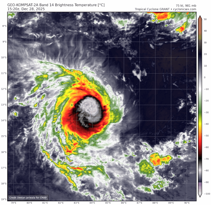
Finnally it has an eye.

3 likes
Visit the Caribbean-Central America Weather Thread where you can find at first post web cams,radars
and observations from Caribbean basin members Click Here
and observations from Caribbean basin members Click Here
-
Hurricane2022
- Category 5
- Posts: 2094
- Joined: Tue Aug 23, 2022 11:38 pm
- Location: Araçatuba, Brazil
Re: SIO: GRANT - Tropical Cyclone 03U
RSMC La Reunion: 85 kt/966 mb (roughly 95 kt 1-min)
JTWC: 80 kt/978 mb.
Both estimates are from 18z.
JTWC: 80 kt/978 mb.
Both estimates are from 18z.
0 likes
Sorry for the bad English sometimes...!
For reliable and detailed information for any meteorological phenomenon, please consult the National Hurricane Center, Joint Typhoon Warning Center , or your local Meteo Center.
--------
ECCE OMNIA NOVA FACIAM (Ap 21,5).
For reliable and detailed information for any meteorological phenomenon, please consult the National Hurricane Center, Joint Typhoon Warning Center , or your local Meteo Center.
--------
ECCE OMNIA NOVA FACIAM (Ap 21,5).

Re: SIO: GRANT - Tropical Cyclone 03U
2 likes
TC naming lists: retirements and intensity
Most aggressive Advisory #1's in North Atlantic (cr. kevin for starting the list)
Most aggressive Advisory #1's in North Atlantic (cr. kevin for starting the list)
-
cycloneye
- Admin
- Posts: 149791
- Age: 69
- Joined: Thu Oct 10, 2002 10:54 am
- Location: San Juan, Puerto Rico
Re: SIO: GRANT - Tropical Cyclone 03U
Tropical Cyclone Grant
Estimated maximum wind speeds (averaged over 10 minutes) at sea: 155 km/h.
Estimated maximum gusts at sea: 220 km/h.
Estimated pressure at the center: 966 hPa.
Position on December 28 at 10 p.m. local time: 13.2 South / 83.5 East.
Distance from the coast of Réunion: 3055 km to the East-Northeast sector
Distance from Mayotte: 4150 km to the sector: EAST
Movement: WEST-SOUTH-WEST, at 20 km/h.
System information:
Tropical Cyclone Grant is developing over the eastern part of the basin, more than 2,000 km northeast of Rodrigues. It continues to intensify and is expected to reach intense tropical cyclone status by Monday morning. It is a very small system, with dangerous winds remaining confined to a radius of 50 to 80 km from its center. Over the next five days, Grant is expected to move west-southwest but should remain a safe distance from inhabited land (more than 500 km northeast of Rodrigues).
Information for Réunion and/or Mayotte:
No impact from this system is expected over the next 5 days for Réunion and Mayotte. Beyond the next 5 days, it is still far too early to estimate any potential impact from this system given the numerous uncertainties (trajectory, intensity, size of the phenomenon).
0 likes
Visit the Caribbean-Central America Weather Thread where you can find at first post web cams,radars
and observations from Caribbean basin members Click Here
and observations from Caribbean basin members Click Here
-
Hurricane2022
- Category 5
- Posts: 2094
- Joined: Tue Aug 23, 2022 11:38 pm
- Location: Araçatuba, Brazil
Re: SIO: GRANT - Tropical Cyclone 03U


TPXS11 PGTW 282044
A. TROPICAL CYCLONE 09S (GRANT)
B. 28/2030Z
C. 13.33S
D. 83.16E
E. SIX/GOES-IO
F. T5.0/5.0/D1.0/24HRS STT: S0.0/03HRS
G. IR/EIR
H. REMARKS: 46A/PBO EMBD CNTR/ANMTN. LLCC EMBEDDED IN B YIELDS A DT
OF 5.0. MET AND PT AGREE. DBO DT.
I. ADDITIONAL POSITIONS: NONE
BRYANT
A. TROPICAL CYCLONE 09S (GRANT)
B. 28/2030Z
C. 13.33S
D. 83.16E
E. SIX/GOES-IO
F. T5.0/5.0/D1.0/24HRS STT: S0.0/03HRS
G. IR/EIR
H. REMARKS: 46A/PBO EMBD CNTR/ANMTN. LLCC EMBEDDED IN B YIELDS A DT
OF 5.0. MET AND PT AGREE. DBO DT.
I. ADDITIONAL POSITIONS: NONE
BRYANT
It's so painful to see Dvorak agencies "trying" to do fixes on small cyclones like Grant

1 likes
Sorry for the bad English sometimes...!
For reliable and detailed information for any meteorological phenomenon, please consult the National Hurricane Center, Joint Typhoon Warning Center , or your local Meteo Center.
--------
ECCE OMNIA NOVA FACIAM (Ap 21,5).
For reliable and detailed information for any meteorological phenomenon, please consult the National Hurricane Center, Joint Typhoon Warning Center , or your local Meteo Center.
--------
ECCE OMNIA NOVA FACIAM (Ap 21,5).
Re: SIO: GRANT - Tropical Cyclone 03U
Ramping up.
.gif)
2 likes
TC naming lists: retirements and intensity
Most aggressive Advisory #1's in North Atlantic (cr. kevin for starting the list)
Most aggressive Advisory #1's in North Atlantic (cr. kevin for starting the list)
-
Hurricane2022
- Category 5
- Posts: 2094
- Joined: Tue Aug 23, 2022 11:38 pm
- Location: Araçatuba, Brazil
Re: SIO: GRANT - Tropical Cyclone 03U
0 likes
Sorry for the bad English sometimes...!
For reliable and detailed information for any meteorological phenomenon, please consult the National Hurricane Center, Joint Typhoon Warning Center , or your local Meteo Center.
--------
ECCE OMNIA NOVA FACIAM (Ap 21,5).
For reliable and detailed information for any meteorological phenomenon, please consult the National Hurricane Center, Joint Typhoon Warning Center , or your local Meteo Center.
--------
ECCE OMNIA NOVA FACIAM (Ap 21,5).
-
Hurricane2022
- Category 5
- Posts: 2094
- Joined: Tue Aug 23, 2022 11:38 pm
- Location: Araçatuba, Brazil
Re: SIO: GRANT - Tropical Cyclone 03U
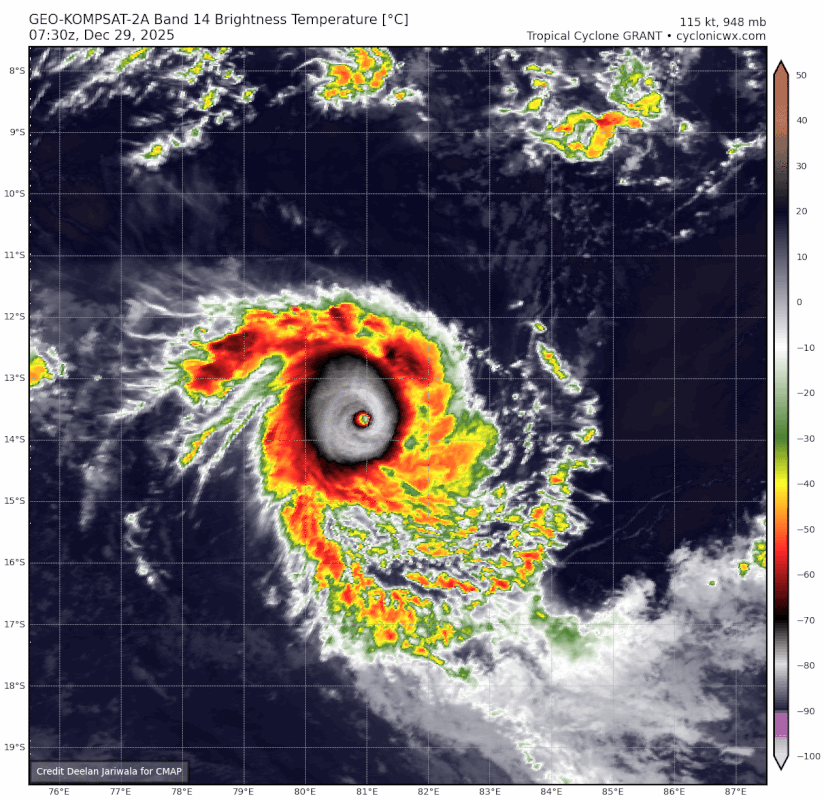
A microscopic T7.5


2 likes
Sorry for the bad English sometimes...!
For reliable and detailed information for any meteorological phenomenon, please consult the National Hurricane Center, Joint Typhoon Warning Center , or your local Meteo Center.
--------
ECCE OMNIA NOVA FACIAM (Ap 21,5).
For reliable and detailed information for any meteorological phenomenon, please consult the National Hurricane Center, Joint Typhoon Warning Center , or your local Meteo Center.
--------
ECCE OMNIA NOVA FACIAM (Ap 21,5).
-
Hurricane2022
- Category 5
- Posts: 2094
- Joined: Tue Aug 23, 2022 11:38 pm
- Location: Araçatuba, Brazil
Re: SIO: GRANT - Tropical Cyclone 03U
That's a Category 5.
https://x.com/i/status/2005589896304668994
https://x.com/i/status/2005590342759027108
https://x.com/i/status/2005589896304668994
https://x.com/i/status/2005590342759027108
1 likes
Sorry for the bad English sometimes...!
For reliable and detailed information for any meteorological phenomenon, please consult the National Hurricane Center, Joint Typhoon Warning Center , or your local Meteo Center.
--------
ECCE OMNIA NOVA FACIAM (Ap 21,5).
For reliable and detailed information for any meteorological phenomenon, please consult the National Hurricane Center, Joint Typhoon Warning Center , or your local Meteo Center.
--------
ECCE OMNIA NOVA FACIAM (Ap 21,5).
-
Hurricane2022
- Category 5
- Posts: 2094
- Joined: Tue Aug 23, 2022 11:38 pm
- Location: Araçatuba, Brazil
Re: SIO: GRANT - Tropical Cyclone 03U
0 likes
Sorry for the bad English sometimes...!
For reliable and detailed information for any meteorological phenomenon, please consult the National Hurricane Center, Joint Typhoon Warning Center , or your local Meteo Center.
--------
ECCE OMNIA NOVA FACIAM (Ap 21,5).
For reliable and detailed information for any meteorological phenomenon, please consult the National Hurricane Center, Joint Typhoon Warning Center , or your local Meteo Center.
--------
ECCE OMNIA NOVA FACIAM (Ap 21,5).
Re: SIO: GRANT - Tropical Cyclone 03U
Peak and recent weakening. Too bad that the resolution is low.
0 likes
TC naming lists: retirements and intensity
Most aggressive Advisory #1's in North Atlantic (cr. kevin for starting the list)
Most aggressive Advisory #1's in North Atlantic (cr. kevin for starting the list)
-
cycloneye
- Admin
- Posts: 149791
- Age: 69
- Joined: Thu Oct 10, 2002 10:54 am
- Location: San Juan, Puerto Rico
Re: SIO: GRANT - Tropical Cyclone 03U
0 likes
Visit the Caribbean-Central America Weather Thread where you can find at first post web cams,radars
and observations from Caribbean basin members Click Here
and observations from Caribbean basin members Click Here
-
Yellow Evan

- Professional-Met

- Posts: 16257
- Age: 27
- Joined: Fri Jul 15, 2011 12:48 pm
- Location: Henderson, Nevada/Honolulu, HI
- Contact:
Re: SIO: GRANT - Tropical Cyclone 03U
Do think this was our eighth Category 5 of the year this morning.
3 likes
Who is online
Users browsing this forum: No registered users and 138 guests