NATL: MELISSA - Models

Moderator: S2k Moderators

Message
Author
User avatar
sasha_B
Category 1
Category 1
Posts: 283
Age: 25
Joined: Sun Jun 30, 2024 4:32 pm
Location: Charleston, SC

Re: NATL: INVEST 98L - Models

#41 Postby sasha_B » Sun Oct 19, 2025 10:12 am

zzzh wrote:https://i.imgur.com/NajP9Cy.png
One FVN3 member has 182kt/878mb :lol:


Always neat to see 'crazy model runs' like this, even if it's only a single ensemble member this time (...worth noting the number of non-record-breaking Cat 5 members on that run, though). Infinitessimally unlikely for such a thing to happen, but probably not thermodynamically impossible: 878 / 182 exceeds Wilma and Allen's records for the Atlantic (the latter by a wide margin) but would fall within the observed bounds of October western-hemisphere TC intensity.

On the other hand, most of the guidance for now shows 98L becoming a TC of low-to-moderate intensity (if it develops at all, which isn't a given). I think the more realistic concern should it approach land would be rainfall & slow forward motion, like we saw with Sara last year. ERI requires everything to go right/wrong.
2 likes   

User avatar
SouthFLTropics
Category 5
Category 5
Posts: 4258
Age: 50
Joined: Thu Aug 14, 2003 8:04 am
Location: Port St. Lucie, Florida

Re: NATL: INVEST 98L - Models

#42 Postby SouthFLTropics » Sun Oct 19, 2025 10:55 am

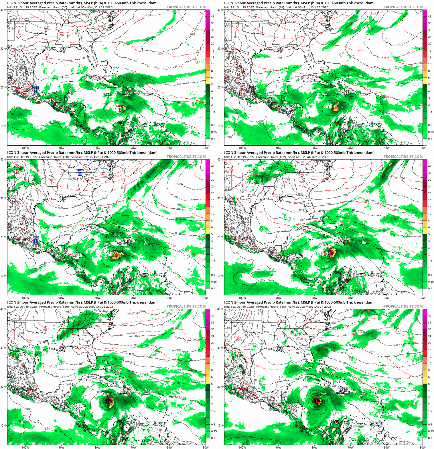
12z ICON with a 954mb hurricane SW of Jamaica and moving slowly west at hour 180.
0 likes   
Fourth Generation Florida Native

Personal Storm History: David 79, Andrew 92, Erin 95, Floyd 99, Irene 99, Frances 04, Jeanne 04, Wilma 05, Matthew 16, Irma 17, Ian 22, Nicole 22, Milton 24

User avatar
kevin
Category 5
Category 5
Posts: 2878
Age: 27
Joined: Wed Aug 28, 2019 4:35 am

Re: NATL: INVEST 98L - Models

#43 Postby kevin » Sun Oct 19, 2025 10:57 am

We're still in the very early stage of this invest, but if the c5 runs of 98L become reality this would be the only season besides 2005 on record to feature 3 or more cat 5 hurricanes (2005 had 4).

Even if it'd 'just' become a MH, the season would be at 13/5/4 which is still quite a unique season total. Many of the similar seasons like 1894 (7/5/4) 1909 (12/6/4) & 1964 (13/7/5) are from before the satellite era when these high MH/TS and MH/H ratios were more common due to missed storms. The only kinda similar 'recent' season is 1988 with 12/5/3.
4 likes   

User avatar
SFLcane
S2K Supporter
S2K Supporter
Posts: 10281
Age: 48
Joined: Sat Jun 05, 2010 1:44 pm
Location: Lake Worth Florida

Re: NATL: INVEST 98L - Models

#44 Postby SFLcane » Sun Oct 19, 2025 11:08 am

SouthFLTropics wrote:12z ICON with a 954mb hurricane SW of Jamaica and moving slowly west at hour 180.


Indeed!

Image
4 likes   

User avatar
SFLcane
S2K Supporter
S2K Supporter
Posts: 10281
Age: 48
Joined: Sat Jun 05, 2010 1:44 pm
Location: Lake Worth Florida

Re: NATL: INVEST 98L - Models

#45 Postby SFLcane » Sun Oct 19, 2025 11:11 am

SouthFLTropics wrote:12z ICON with a 954mb hurricane SW of Jamaica and moving slowly west at hour 180.


Andys model again 06z run has another C5 heading into the NW carib. :eek:

https://storm.aoml.noaa.gov/basin/anima ... casthr=000

Image
4 likes   

User avatar
Blown Away
S2K Supporter
S2K Supporter
Posts: 10253
Joined: Wed May 26, 2004 6:17 am

Re: NATL: INVEST 98L - Models

#46 Postby Blown Away » Sun Oct 19, 2025 11:47 am

Image

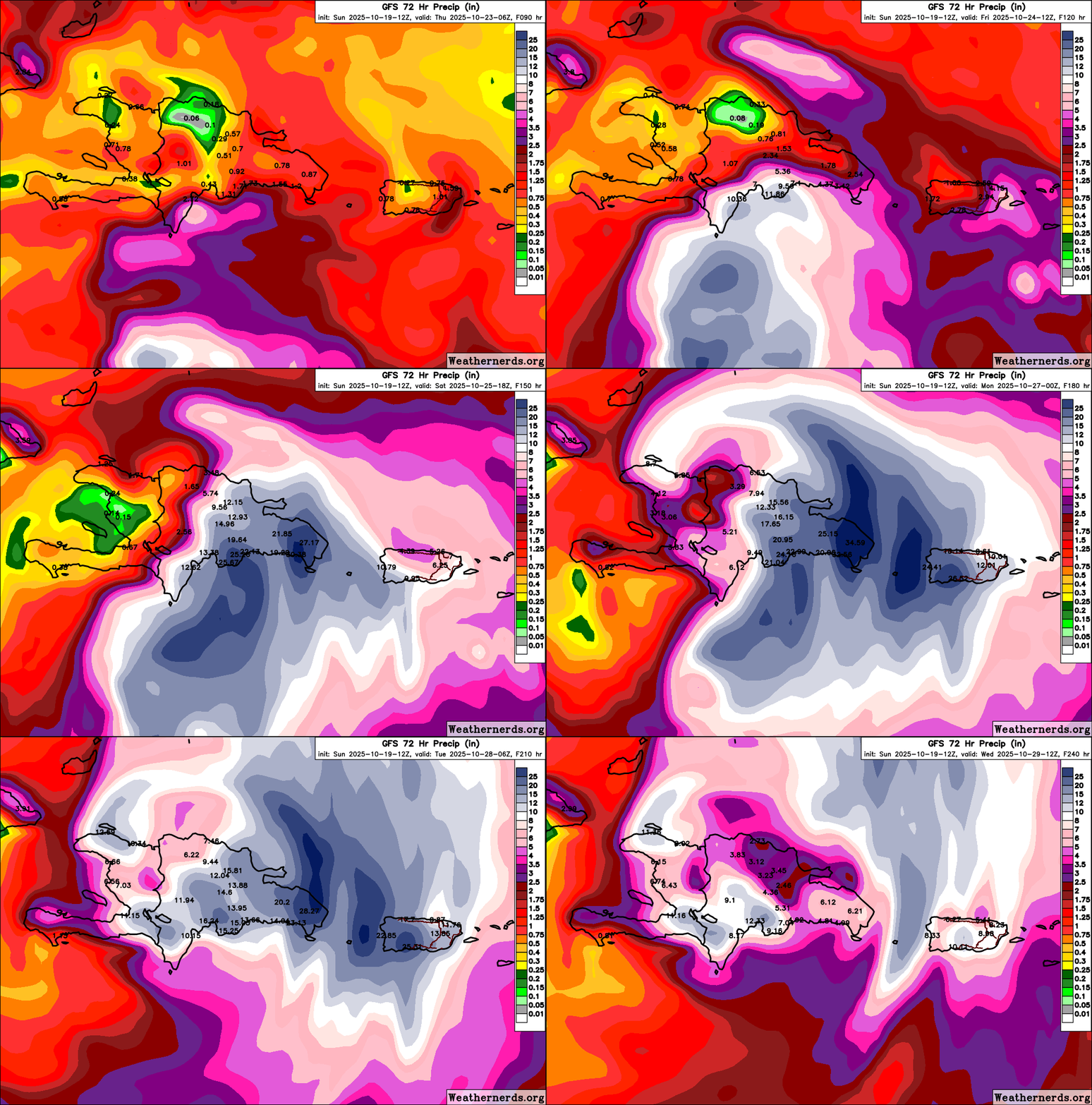
Yikes for DR/PR if the GFS is right! :double:
2 likes   
Hurricane Eye Experience: David 79, Irene 99, Frances 04, Jeanne 04, Wilma 05… Hurricane Brush Experience: Andrew 92, Erin 95, Floyd 99, Matthew 16, Irma 17, Ian 22, Nicole 22…

User avatar
NDG
S2K Supporter
S2K Supporter
Posts: 15508
Joined: Sun Jul 09, 2006 10:14 pm
Location: Orlando, FL

Re: NATL: INVEST 98L - Models

#47 Postby NDG » Sun Oct 19, 2025 11:51 am

Don't put too much stock on the GFS.

 https://x.com/NDGMETCHEF/status/1979948650596880611

7 likes   

Pelicane
Tropical Storm
Tropical Storm
Posts: 190
Joined: Tue Sep 13, 2022 1:52 pm
Location: Lafayette, Louisiana

Re: NATL: INVEST 98L - Models

#48 Postby Pelicane » Sun Oct 19, 2025 12:21 pm

NDG wrote:Don't put too much stock on the GFS.

 https://x.com/NDGMETCHEF/status/1979948650596880611


GEFS trended notably westward FWIW
1 likes   

IsabelaWeather
Category 1
Category 1
Posts: 316
Age: 36
Joined: Tue Jul 07, 2020 7:29 am
Location: Isabela, Puerto Rico

Re: NATL: INVEST 98L - Models

#49 Postby IsabelaWeather » Sun Oct 19, 2025 12:31 pm

Pelicane wrote:
NDG wrote:Don't put too much stock on the GFS.

 https://x.com/NDGMETCHEF/status/1979948650596880611


GEFS trended notably westward FWIW


I'm not sure, looks like more members are east at 12z than 6z
0 likes   

User avatar
Ubuntwo
Category 5
Category 5
Posts: 1459
Age: 31
Joined: Thu Oct 05, 2017 10:41 pm

Re: NATL: INVEST 98L - Models

#50 Postby Ubuntwo » Sun Oct 19, 2025 12:35 pm

IsabelaWeather wrote:
Pelicane wrote:
NDG wrote:Don't put too much stock on the GFS.

 https://x.com/NDGMETCHEF/status/1979948650596880611


GEFS trended notably westward FWIW


I'm not sure, looks like more members are east at 12z than 6z

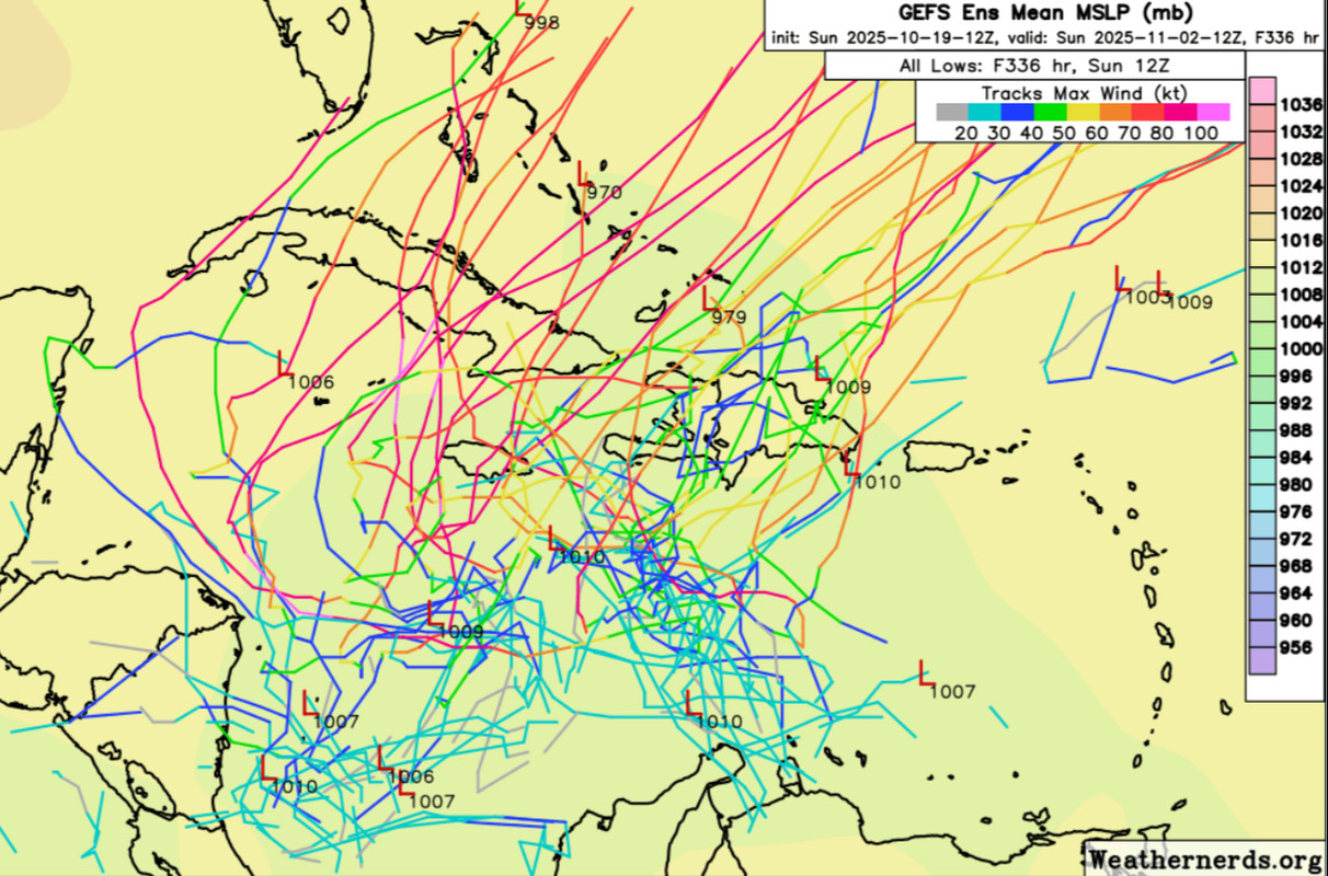
Fewer members doing a quick curve through Hispaniola (the western group is larger), but that west group is not as far west. Fewer members drifting around. Looks like the mean clusters through eastern Cuba.
2 likes   
Kendall -> SLO -> PBC

Memorable Storms: Katrina (for its Florida landfall...) Wilma Matthew Irma

MEANINGLESS_NUMBERS
Category 2
Category 2
Posts: 502
Joined: Mon Nov 02, 2020 1:43 pm

Re: NATL: INVEST 98L - Models

#51 Postby MEANINGLESS_NUMBERS » Sun Oct 19, 2025 12:51 pm

No development on the Euro. Minimal TS on the Canadian. Yes, some models show Cat 5 but even a hurricane is not a sure-thing.
1 likes   
Emily '87, Felix '95, Gert '99, Fabian '03, Humberto '19, Paulette '20, Teddy '20, Fiona '22, Lee '23, Ernesto '24, Humberto/Imelda '25

User avatar
Ubuntwo
Category 5
Category 5
Posts: 1459
Age: 31
Joined: Thu Oct 05, 2017 10:41 pm

Re: NATL: INVEST 98L - Models

#52 Postby Ubuntwo » Sun Oct 19, 2025 1:07 pm

MEANINGLESS_NUMBERS wrote:No development on the Euro. Minimal TS on the Canadian. Yes, some models show Cat 5 but even a hurricane is not a sure-thing.

12z Euro has a 983mb hurricane into eastern Cuba, passing through the Bahamas and peaking in the 960s.
2 likes   
Kendall -> SLO -> PBC

Memorable Storms: Katrina (for its Florida landfall...) Wilma Matthew Irma

User avatar
cycloneye
Admin
Admin
Posts: 148541
Age: 69
Joined: Thu Oct 10, 2002 10:54 am
Location: San Juan, Puerto Rico

Re: NATL: INVEST 98L - Models

#53 Postby cycloneye » Sun Oct 19, 2025 1:09 pm

12z EURO develops and tracks NE thru Cuba.

Image
2 likes   
Visit the Caribbean-Central America Weather Thread where you can find at first post web cams,radars
and observations from Caribbean basin members Click Here

IsabelaWeather
Category 1
Category 1
Posts: 316
Age: 36
Joined: Tue Jul 07, 2020 7:29 am
Location: Isabela, Puerto Rico

Re: NATL: INVEST 98L - Models

#54 Postby IsabelaWeather » Sun Oct 19, 2025 1:16 pm

cycloneye wrote:12z EURO develops and tracks NE thru Cuba.

https://i.imgur.com/VYAu2R8.gif


Caving to the GFS?
0 likes   

User avatar
Ubuntwo
Category 5
Category 5
Posts: 1459
Age: 31
Joined: Thu Oct 05, 2017 10:41 pm

Re: NATL: INVEST 98L - Models

#55 Postby Ubuntwo » Sun Oct 19, 2025 1:49 pm

IsabelaWeather wrote:
cycloneye wrote:12z EURO develops and tracks NE thru Cuba.

https://i.imgur.com/VYAu2R8.gif


Caving to the GFS?

GFS develops very quickly (in about three days) and turns almost immediately into Hispaniola. The Euro takes far longer to develop - about a whole week. This timing difference hasn't tightened up much unfortunately. The Euro is most similar to the western camp of the GEFS in that slower development and track a bit further west.
2 likes   
Kendall -> SLO -> PBC

Memorable Storms: Katrina (for its Florida landfall...) Wilma Matthew Irma

User avatar
Ubuntwo
Category 5
Category 5
Posts: 1459
Age: 31
Joined: Thu Oct 05, 2017 10:41 pm

Re: NATL: INVEST 98L - Models

#56 Postby Ubuntwo » Sun Oct 19, 2025 1:50 pm

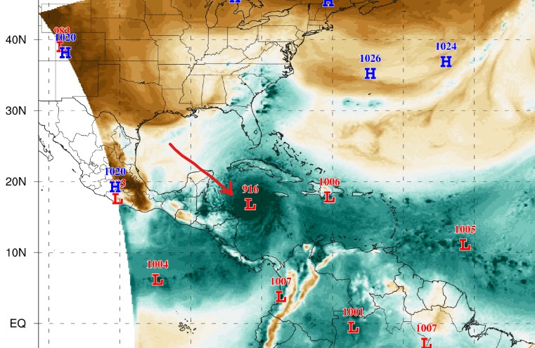
12z FNV3 is back to favoring the GFS solution:
Image
0 likes   
Kendall -> SLO -> PBC

Memorable Storms: Katrina (for its Florida landfall...) Wilma Matthew Irma

User avatar
Blown Away
S2K Supporter
S2K Supporter
Posts: 10253
Joined: Wed May 26, 2004 6:17 am

Re: NATL: INVEST 98L - Models

#57 Postby Blown Away » Sun Oct 19, 2025 2:15 pm

IsabelaWeather wrote:
cycloneye wrote:12z EURO develops and tracks NE thru Cuba.

https://i.imgur.com/VYAu2R8.gif


Caving to the GFS?


I don’t think so, just closing in on time and accuracy. GFS has slowly moved W away from PR towards EURO.
0 likes   
Hurricane Eye Experience: David 79, Irene 99, Frances 04, Jeanne 04, Wilma 05… Hurricane Brush Experience: Andrew 92, Erin 95, Floyd 99, Matthew 16, Irma 17, Ian 22, Nicole 22…

User avatar
cycloneye
Admin
Admin
Posts: 148541
Age: 69
Joined: Thu Oct 10, 2002 10:54 am
Location: San Juan, Puerto Rico

Re: NATL: INVEST 98L - Models

#58 Postby cycloneye » Sun Oct 19, 2025 2:23 pm

Image

Image
1 likes   
Visit the Caribbean-Central America Weather Thread where you can find at first post web cams,radars
and observations from Caribbean basin members Click Here

User avatar
Blown Away
S2K Supporter
S2K Supporter
Posts: 10253
Joined: Wed May 26, 2004 6:17 am

Re: NATL: INVEST 98L - Models

#59 Postby Blown Away » Sun Oct 19, 2025 2:26 pm

Image

12z GEFS… Wide W swing now with stronger members…
8 likes   
Hurricane Eye Experience: David 79, Irene 99, Frances 04, Jeanne 04, Wilma 05… Hurricane Brush Experience: Andrew 92, Erin 95, Floyd 99, Matthew 16, Irma 17, Ian 22, Nicole 22…

IsabelaWeather
Category 1
Category 1
Posts: 316
Age: 36
Joined: Tue Jul 07, 2020 7:29 am
Location: Isabela, Puerto Rico

Re: NATL: INVEST 98L - Models

#60 Postby IsabelaWeather » Sun Oct 19, 2025 3:55 pm

Blown Away wrote:
IsabelaWeather wrote:
cycloneye wrote:12z EURO develops and tracks NE thru Cuba.

https://i.imgur.com/VYAu2R8.gif


Caving to the GFS?


I don’t think so, just closing in on time and accuracy. GFS has slowly moved W away from PR towards EURO.


I wouldnt say that, I didnt mean a track to PR, the gfs hasnt shown that in like 4 or 5 runs, i mean a track into Hispaniola and the NE movement. Focusing on the NE movement as opposed to N over W cuba
1 likes   


Return to “2025”

Who is online

Users browsing this forum: No registered users and 18 guests