BobHarlem wrote:Blown Away wrote:wzrgirl1 wrote:http://moe.met.fsu.edu/tcgengifs/cmchr/2025102300/slp29.png
Can someone explain this to me please?

[url]https://i.postimg.cc/YqrYNtpq/gem-mslp-pcpn-watl-fh12-192.gif [/url]
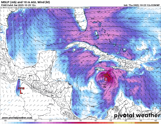
Another view of the 12z CMC (Canadian) model run that continues to show Melissa moving NE passing just SE of Florida. It's the W outlier.
12z UK Met is also a little further west than that (And still ultra weak)
Indeed, the 12Z UKMET after moving very slowly 100 miles ENE of NE Honduras, turns NE and goes over the Caymans. Also, it’s significantly stronger than previous runs with 997 mb:
ROPICAL STORM MELISSA ANALYSED POSITION : 15.5N 75.5W
ATCF IDENTIFIER : AL132025
LEAD CENTRAL MAXIMUM WIND
VERIFYING TIME TIME POSITION PRESSURE (MB) SPEED (KNOTS)
-------------- ---- -------- ------------- -------------
1200UTC 23.10.2025 0 15.5N 75.5W 1005 34
0000UTC 24.10.2025 12 15.3N 75.9W 1004 29
1200UTC 24.10.2025 24 15.4N 75.3W 1004 28
0000UTC 25.10.2025 36 16.1N 75.3W 1003 30
1200UTC 25.10.2025 48 16.5N 75.9W 1004 29
0000UTC 26.10.2025 60 16.6N 76.2W 1004 28
1200UTC 26.10.2025 72 16.7N 77.7W 1004 28
0000UTC 27.10.2025 84 16.9N 79.4W 1004 25
1200UTC 27.10.2025 96 16.1N 80.9W 1003 27
0000UTC 28.10.2025 108 15.9N 81.4W 1002 25
1200UTC 28.10.2025 120 16.2N 82.5W 1003 28
0000UTC 29.10.2025 132 15.9N 82.6W 1004 29
1200UTC 29.10.2025 144 16.9N 83.2W 1002 35
0000UTC 30.10.2025 156 17.6N 83.0W 1000 37
1200UTC 30.10.2025 168 19.8N 80.9W 997 41


