NATL: GABRIELLE - Post-Tropical - Discussion
Moderator: S2k Moderators
-
HurricaneRyan
- Category 3

- Posts: 846
- Age: 32
- Joined: Sun Dec 05, 2010 3:05 pm
Re: NATL: GABRIELLE - Hurricane - Discussion
Strongest Gabrielle we've had since 1989, much like how 2024's Helene was the strongest since 1988's Helene, but this time Gabby won't be harming anyone, just like back in 1989.
3 likes
Kay '22 Hilary '23
-
Hurricane2022

- Category 5

- Posts: 2016
- Joined: Tue Aug 23, 2022 11:38 pm
- Location: Araçatuba, Brazil
Re: NATL: GABRIELLE - Hurricane - Discussion
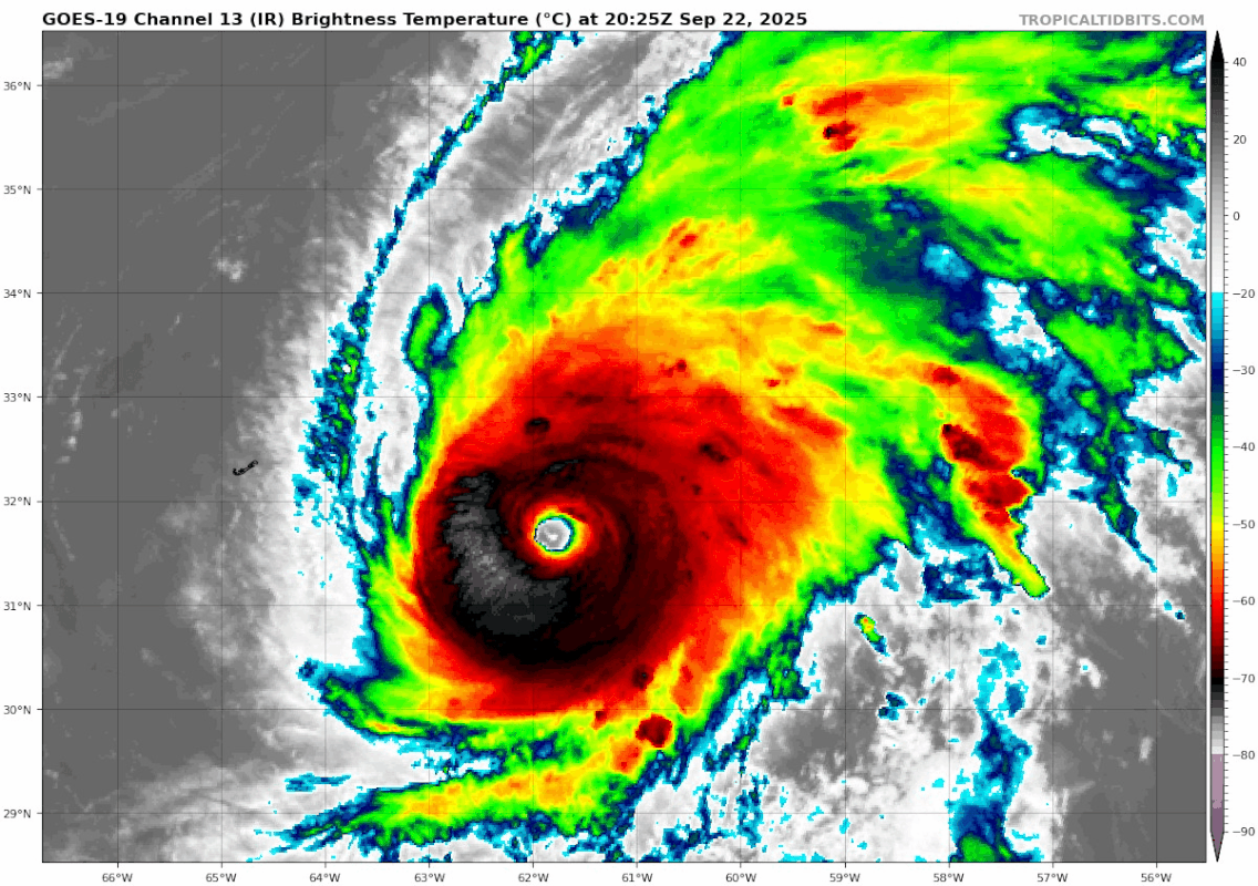
Gabi is looking even more beautiful, after the recon left. I think we're currently at her peak intensity, with winds around 130 kt and pressure around 942 mb.
2 likes
Sorry for the bad English sometimes...!
For reliable and detailed information for any meteorological phenomenon, please consult the National Hurricane Center, Joint Typhoon Warning Center , or your local Meteo Center.
--------
ECCE OMNIA NOVA FACIAM (Ap 21,5).
For reliable and detailed information for any meteorological phenomenon, please consult the National Hurricane Center, Joint Typhoon Warning Center , or your local Meteo Center.
--------
ECCE OMNIA NOVA FACIAM (Ap 21,5).

Re: NATL: GABRIELLE - Hurricane - Discussion
1 likes
TC naming lists: retirements and intensity
Most aggressive Advisory #1's in North Atlantic (cr. kevin for starting the list)
Most aggressive Advisory #1's in North Atlantic (cr. kevin for starting the list)


Re: NATL: GABRIELLE - Hurricane - Discussion
HurricaneRyan wrote:Strongest Gabrielle we've had since 1989
Gabrielle 1989 was wild. For a storm that tracked up 60W the swells on the east coast were huge. The bouy off Delaware peaked at 8 feet @ 17 second periods around Sept 8. That's 10 foot+ surf and many parts of the coast saw much larger.
1 likes
-
CrazyC83
- Professional-Met

- Posts: 34315
- Joined: Tue Mar 07, 2006 11:57 pm
- Location: Deep South, for the first time!
Re: NATL: GABRIELLE - Hurricane - Discussion
Maybe the peak intensity could be bumped to 125 kt? Although I think the highest ADT was T6.3 and Dvorak was lining up very well with the Recon estimates.
How much instability and will there be cool upper-level temperatures ahead? That could allow Gabrielle to hold a lot of the intensity en route to the Azores.
How much instability and will there be cool upper-level temperatures ahead? That could allow Gabrielle to hold a lot of the intensity en route to the Azores.
1 likes
-
CrazyC83
- Professional-Met
- Posts: 34315
- Joined: Tue Mar 07, 2006 11:57 pm
- Location: Deep South, for the first time!
Re: NATL: GABRIELLE - Hurricane - Discussion
I think the BT will have a break in the track (as a TC) and that there will be an 18-24 hour period where Gabrielle was just a low, not a tropical cyclone.
1 likes


Re: NATL: GABRIELLE - Hurricane - Discussion
oh my god this is so close to an instantaneous T7.0 at 32.5N if the NW quadrant would grow just a bit, there's no way this is still 120kts

5 likes
-
cycloneye

- Admin

- Posts: 149275
- Age: 69
- Joined: Thu Oct 10, 2002 10:54 am
- Location: San Juan, Puerto Rico
Re: NATL: GABRIELLE - Hurricane - Discussion
The TCR post season will be very interesting to see if there are changes or not.
3 likes
Visit the Caribbean-Central America Weather Thread where you can find at first post web cams,radars
and observations from Caribbean basin members Click Here
and observations from Caribbean basin members Click Here
-
cheezyWXguy

- Category 5
- Posts: 6281
- Joined: Mon Feb 13, 2006 12:29 am
- Location: Dallas, TX
Re: NATL: GABRIELLE - Hurricane - Discussion
Gabrielle’s IR satellite appearance honestly reminds me of Laura’s as it was approaching landfall. It wouldn’t take much to convince me they’re both about equal in strength either, 120kt for the current intensity seems low.
4 likes
Re: NATL: GABRIELLE - Hurricane - Discussion
0 likes
TC naming lists: retirements and intensity
Most aggressive Advisory #1's in North Atlantic (cr. kevin for starting the list)
Most aggressive Advisory #1's in North Atlantic (cr. kevin for starting the list)

Re: NATL: GABRIELLE - Hurricane - Discussion
I’d be shocked if this wasn’t at least a ~130 kt storm at its peak. I wonder what, if any, changes will be made in post.
0 likes
-
tolakram
- Admin
- Posts: 20178
- Age: 62
- Joined: Sun Aug 27, 2006 8:23 pm
- Location: Florence, KY (name is Mark)
Re: NATL: GABRIELLE - Hurricane - Discussion
Stay on topic please, I deleted a few meme posts. Use PM's if it's not on topic.
0 likes
M a r k
- - - - -
Join us in chat: Storm2K Chatroom Invite. Android and IOS apps also available.
The posts in this forum are NOT official forecasts and should not be used as such. Posts are NOT endorsed by any professional institution or STORM2K.org. For official information and forecasts, please refer to NHC and NWS products.
-
cycloneye
- Admin
- Posts: 149275
- Age: 69
- Joined: Thu Oct 10, 2002 10:54 am
- Location: San Juan, Puerto Rico
Re: NATL: GABRIELLE - Hurricane - Discussion
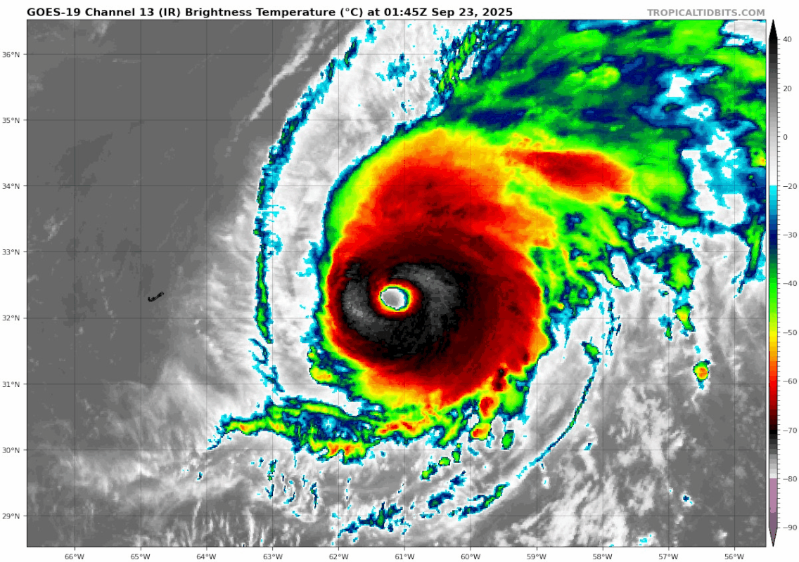
Hanging on at 120kts.
AL, 07, 2025092312, , BEST, 0, 335N, 592W, 120, 948, HU
0 likes
Visit the Caribbean-Central America Weather Thread where you can find at first post web cams,radars
and observations from Caribbean basin members Click Here
and observations from Caribbean basin members Click Here

Re: NATL: GABRIELLE - Hurricane - Discussion
CrazyC83 wrote:Maybe the peak intensity could be bumped to 125 kt? Although I think the highest ADT was T6.3 and Dvorak was lining up very well with the Recon estimates.
How much instability and will there be cool upper-level temperatures ahead? That could allow Gabrielle to hold a lot of the intensity en route to the Azores.
The final pass found Gabrielle still strengthening, with a pressure drop into the 940s and 135kt 2km winds on the TDR. This appeared to directly support 120kt.
During the final pass, there was still convective debris in the eye with mesovorts visible. The satellite data shows these mesovorts rounded into a cleaner eye, which is usually tied with pressure falls and a spike in winds to 130kt territory. See Laura and Ida for examples where recon caught the mesovort smoothing process. This is also Dvorak's weak point: smooth, warm eyes with a relatively low tropopause keeping CDO convection on the warmer side.
I think this comparison between the last recon pass (with strong support for 120kt) and a few hours later speaks for itself.

4 likes
Kendall -> SLO -> PBC
Memorable Storms: Katrina (for its Florida landfall...) Wilma Matthew Irma
Memorable Storms: Katrina (for its Florida landfall...) Wilma Matthew Irma
Re: NATL: GABRIELLE - Hurricane - Discussion
Gabrielle is holding on remarkably well given the latitude, still with a perfectly round and clear eye.
For comparison, Erin started deteriorating very soon after its peak and never really looked nice again. At the latitude that Gabrielle is at right now, Erin was a large, sprawling and weakening Cat 2.
For comparison, Erin started deteriorating very soon after its peak and never really looked nice again. At the latitude that Gabrielle is at right now, Erin was a large, sprawling and weakening Cat 2.
3 likes
TC naming lists: retirements and intensity
Most aggressive Advisory #1's in North Atlantic (cr. kevin for starting the list)
Most aggressive Advisory #1's in North Atlantic (cr. kevin for starting the list)

Re: NATL: GABRIELLE - Hurricane - Discussion
Teban54 wrote:Gabrielle is holding on remarkably well given the latitude, still with a perfectly round and clear eye.
For comparison, Erin started deteriorating very soon after its peak and never really looked nice again. At the latitude that Gabrielle is at right now, Erin was a large, sprawling and weakening Cat 2.
Getting Dvorak T6.1 at 33+ degrees latitude is indeed extremely impressive. Last one to get close in the Atlantic was Fiona in 2022 (T5.9 33.7 deg).
4 likes
-
cycloneye
- Admin
- Posts: 149275
- Age: 69
- Joined: Thu Oct 10, 2002 10:54 am
- Location: San Juan, Puerto Rico
Re: NATL: GABRIELLE - Hurricane - Discussion
Nice.

5 likes
Visit the Caribbean-Central America Weather Thread where you can find at first post web cams,radars
and observations from Caribbean basin members Click Here
and observations from Caribbean basin members Click Here
Re: NATL: GABRIELLE - Hurricane - Discussion
kevin wrote:Teban54 wrote:Gabrielle is holding on remarkably well given the latitude, still with a perfectly round and clear eye.
For comparison, Erin started deteriorating very soon after its peak and never really looked nice again. At the latitude that Gabrielle is at right now, Erin was a large, sprawling and weakening Cat 2.
Getting Dvorak T6.1 at 33+ degrees latitude is indeed extremely impressive. Last one to get close in the Atlantic was Fiona in 2022 (T5.9 33.7 deg).
I did a slightly more extensive search and the result makes Gabrielle even more impressive. There is not a single hurricane in the modern ADT archive (since 2003) which attained T6.0+ at Gabrielle's latitude. In fact, before Fiona in 2022 you'd have to go all the way back to Diana in 1984 to find a cat 4 at this latitude. Ella 1978, Gladys 1975 and Helene 1958 are the only other TCs in the database which have reached 120 kt at this latitude.
6 likes
-
cycloneye
- Admin
- Posts: 149275
- Age: 69
- Joined: Thu Oct 10, 2002 10:54 am
- Location: San Juan, Puerto Rico
Re: NATL: GABRIELLE - Hurricane - Discussion
Not many times we see this for the Azores Islands:
The Azores Meteorological Service has issued a Hurricane Watch for
all the islands of the Azores.
all the islands of the Azores.
5 likes
Visit the Caribbean-Central America Weather Thread where you can find at first post web cams,radars
and observations from Caribbean basin members Click Here
and observations from Caribbean basin members Click Here
Re: NATL: GABRIELLE - Hurricane - Discussion
We have one week to go until October and the only hurricane watch—not even warning—the entire basin has seen has been for the Azores. What a weird season it has been so far.
4 likes
Who is online
Users browsing this forum: No registered users and 26 guests