
NATL: MELISSA - Models
Moderator: S2k Moderators
-
MEANINGLESS_NUMBERS
- Category 2

- Posts: 503
- Joined: Mon Nov 02, 2020 1:43 pm
Re: NATL: MELISSA - Models
12z GFS with 62 inches on rain on Hispaniola. This is more more than twice the record rainfall for a storm (Matthew 2016, 30 inches), and in fact is more than the average annual rainfall! I don't think the magnitude of this potential disaster can be overstated.
3 likes
Emily '87, Felix '95, Gert '99, Fabian '03, Humberto '19, Paulette '20, Teddy '20, Fiona '22, Lee '23, Ernesto '24, Humberto/Imelda '25

Re: NATL: MELISSA - Models
LarryWx wrote:Fancy1002 wrote:Gotta give it to both the GFS and the UKMET for their consistency, even if they end up being dead wrong.
Speaking of the UKMET, the 12Z has a similar path with it still weak although it has been inching further N at the ends of the last few runs. Earlier runs were going into Nicaragua and falling apart. Then they were going toward the Nic/Hond border and/or skimming the N coast of Hond. This latest one goes into the open southern Gulf of Honduras and stalls without falling apart and appears to be starting to strengthen:
TROPICAL STORM MELISSA ANALYSED POSITION : 14.2N 73.9W
ATCF IDENTIFIER : AL132025
LEAD CENTRAL MAXIMUM WIND
VERIFYING TIME TIME POSITION PRESSURE (MB) SPEED (KNOTS)
-------------- ---- -------- ------------- -------------
1200UTC 22.10.2025 0 14.2N 73.9W 1004 35
0000UTC 23.10.2025 12 15.5N 74.8W 1003 39
1200UTC 23.10.2025 24 15.5N 75.8W 1004 36
0000UTC 24.10.2025 36 15.7N 76.2W 1004 28
1200UTC 24.10.2025 48 15.6N 76.2W 1004 26
0000UTC 25.10.2025 60 15.6N 76.5W 1004 27
1200UTC 25.10.2025 72 15.8N 77.0W 1005 28
0000UTC 26.10.2025 84 15.6N 78.3W 1004 27
1200UTC 26.10.2025 96 15.7N 79.7W 1004 25
0000UTC 27.10.2025 108 15.6N 81.4W 1003 22
1200UTC 27.10.2025 120 15.2N 82.6W 1003 24
0000UTC 28.10.2025 132 15.5N 83.7W 1004 20
1200UTC 28.10.2025 144 16.3N 84.8W 1005 23
0000UTC 29.10.2025 156 16.4N 86.3W 1005 27
1200UTC 29.10.2025 168 16.6N 86.5W 1004 34
I stand slightly corrected, sort of.
0 likes
-
SouthFLTropics

- Category 5

- Posts: 4258
- Age: 50
- Joined: Thu Aug 14, 2003 8:04 am
- Location: Port St. Lucie, Florida
Re: NATL: MELISSA - Models
12z CMC track is very similar to 00z but it did inch a little closer to South Florida, crossing mid Cuba and the southern part of Andros Island. Something to keep an eye on in future runs.
1 likes
Fourth Generation Florida Native
Personal Storm History: David 79, Andrew 92, Erin 95, Floyd 99, Irene 99, Frances 04, Jeanne 04, Wilma 05, Matthew 16, Irma 17, Ian 22, Nicole 22, Milton 24
Personal Storm History: David 79, Andrew 92, Erin 95, Floyd 99, Irene 99, Frances 04, Jeanne 04, Wilma 05, Matthew 16, Irma 17, Ian 22, Nicole 22, Milton 24
-
SouthFLTropics
- Category 5
- Posts: 4258
- Age: 50
- Joined: Thu Aug 14, 2003 8:04 am
- Location: Port St. Lucie, Florida
Re: NATL: MELISSA - Models
SouthFLTropics wrote:12z CMC track is very similar to 00z but it did inch a little closer to South Florida, crossing mid Cuba and the southern part of Andros Island. Something to keep an eye on in future runs.
CMC then goes on to slam Melissa into the Jersey Shore and Long Island in the long range.
0 likes
Fourth Generation Florida Native
Personal Storm History: David 79, Andrew 92, Erin 95, Floyd 99, Irene 99, Frances 04, Jeanne 04, Wilma 05, Matthew 16, Irma 17, Ian 22, Nicole 22, Milton 24
Personal Storm History: David 79, Andrew 92, Erin 95, Floyd 99, Irene 99, Frances 04, Jeanne 04, Wilma 05, Matthew 16, Irma 17, Ian 22, Nicole 22, Milton 24
-
SouthFLTropics
- Category 5
- Posts: 4258
- Age: 50
- Joined: Thu Aug 14, 2003 8:04 am
- Location: Port St. Lucie, Florida
Re: NATL: MELISSA - Models

Happy Halloween NYC!!!
3 likes
Fourth Generation Florida Native
Personal Storm History: David 79, Andrew 92, Erin 95, Floyd 99, Irene 99, Frances 04, Jeanne 04, Wilma 05, Matthew 16, Irma 17, Ian 22, Nicole 22, Milton 24
Personal Storm History: David 79, Andrew 92, Erin 95, Floyd 99, Irene 99, Frances 04, Jeanne 04, Wilma 05, Matthew 16, Irma 17, Ian 22, Nicole 22, Milton 24
Re: NATL: MELISSA - Models
This is just my opinion based on the model runs over the last few days. If Melissa gets close enough to slightly hit or barely scrape by South Florida, a direct hit on the northeast is pretty much guaranteed.
2 likes

Re: NATL: MELISSA - Models
Florida might be almost in the clear I’m keeping a close eye on Melissa since I’m going on a cruise next week to Cozumel.
2 likes

Re: NATL: MELISSA - Models
HAFS-B is going nuclear again. Intensifying at 900 mb and still 15 hours remaining this run.
2 likes
-
cycloneye

- Admin

- Posts: 149275
- Age: 69
- Joined: Thu Oct 10, 2002 10:54 am
- Location: San Juan, Puerto Rico
Re: NATL: MELISSA - Models
12z Euro goes nuclear to the 920's.

0 likes
Visit the Caribbean-Central America Weather Thread where you can find at first post web cams,radars
and observations from Caribbean basin members Click Here
and observations from Caribbean basin members Click Here
Re: NATL: MELISSA - Models
12z Euro ravages Jamaica then has a cat 4/5 landfall on Guantanamo Bay
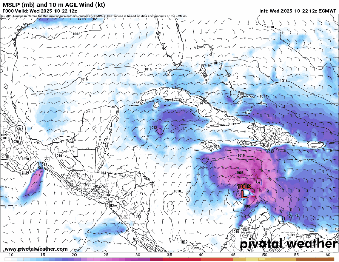
After this it manages to slip in the gap between Nova Scotia and newfoundland and hit in upper Quebec/Côte-Nord.
After this it manages to slip in the gap between Nova Scotia and newfoundland and hit in upper Quebec/Côte-Nord.
Last edited by BobHarlem on Wed Oct 22, 2025 1:31 pm, edited 2 times in total.
1 likes


Re: NATL: MELISSA - Models
SouthFLTropics wrote:12z CMC track is very similar to 00z but it did inch a little closer to South Florida, crossing mid Cuba and the southern part of Andros Island. Something to keep an eye on in future runs.
Okay, someone said it
2 likes
Andy D
(For official information, please refer to the NHC and NWS products.)
(For official information, please refer to the NHC and NWS products.)

Re: NATL: MELISSA - Models
12z HAFS-B ends with 175 kt and 884mb…and still intensifying.
Probably would’ve bottomed out in the 870s if the run went out an extra 6 hours.
Probably would’ve bottomed out in the 870s if the run went out an extra 6 hours.
9 likes
Irene '11 Sandy '12 Hermine '16 5/15/2018 Derecho Fay '20 Isaias '20 Elsa '21 Henri '21 Ida '21
I am only a meteorology enthusiast who knows a decent amount about tropical cyclones. Look to the professional mets, the NHC, or your local weather office for the best information.
I am only a meteorology enthusiast who knows a decent amount about tropical cyclones. Look to the professional mets, the NHC, or your local weather office for the best information.


Re: NATL: MELISSA - Models
boca wrote:Florida might be almost in the clear I’m keeping a close eye on Melissa since I’m going on a cruise next week to Cozumel.
Ha!? Departing this Sunday on Celebrity by chance??
A couple of my best friends are doing the same. Bimini first, then to Cozumel, and then Grand Caymen. I believe SoFlTropics from our forum here is also on a Caribbean cruise next week.
Last edited by chaser1 on Wed Oct 22, 2025 1:28 pm, edited 1 time in total.
0 likes
Andy D
(For official information, please refer to the NHC and NWS products.)
(For official information, please refer to the NHC and NWS products.)
Re: NATL: MELISSA - Models
BobHarlem wrote:12z Euro ravages Jamaica then has a cat 4/5 landfall on Guantanamo Bay
https://i.postimg.cc/FKjLPctw/floop-ecmwf-full-2025102212-sfcwind-mslp-caribbean.gif
After this it manages to slip in the gap between Nova Scotia and newfoundland and hit in upper Quebec.
INTERESTING! Looking closely, the EURO begins to make Melissa's northeast turn right around 144 hrs. CMC does the same at the same time frame, albeit from a further west longitude. I havnt looked yet to see the other model (GFS excluded) forecast point where they too show the storm making her northward or NE turn. The mid-term steering picture may finally becoming a bit more clear once we get past today & tomorrow.
0 likes
Andy D
(For official information, please refer to the NHC and NWS products.)
(For official information, please refer to the NHC and NWS products.)
Re: NATL: MELISSA - Models
chaser1 wrote:boca wrote:Florida might be almost in the clear I’m keeping a close eye on Melissa since I’m going on a cruise next week to Cozumel.
Ha!? Departing this Sunday on Celebrity by chance??
NCL on Wednesday the 29th
0 likes

Re: NATL: MELISSA - Models
BobHarlem wrote:12z Euro ravages Jamaica then has a cat 4/5 landfall on Guantanamo Bay
https://i.postimg.cc/FKjLPctw/floop-ecmwf-full-2025102212-sfcwind-mslp-caribbean.gif
After this it manages to slip in the gap between Nova Scotia and newfoundland and hit in upper Quebec.
The fact that we now have two models curving this back into mainland north america is not great. Both CMC and Euro have the north turn at about hour 144, its just that the CMC has it drift west faster (almost reaching Honduras by that time).
0 likes
Who is online
Users browsing this forum: No registered users and 69 guests