EPAC: ERICK - Post-Tropical - Discussion
Moderator: S2k Moderators
-
Yellow Evan

- Professional-Met

- Posts: 16257
- Age: 27
- Joined: Fri Jul 15, 2011 12:48 pm
- Location: Henderson, Nevada/Honolulu, HI
- Contact:
Re: EPAC: ERICK - Hurricane - Discussion
Not sure this ever had the time to strengthen into Category 4 given the eyewall replacement cycle earlier but there’s at least a case now that the microwave suggested just one eyewall at 6z. This is a hot take admittedly given all the estimates supported >=115 knots at 6z.
1 likes
-
cycloneye

- Admin

- Posts: 149807
- Age: 69
- Joined: Thu Oct 10, 2002 10:54 am
- Location: San Juan, Puerto Rico
Re: EPAC: ERICK - Hurricane - Discussion
0 likes
Visit the Caribbean-Central America Weather Thread where you can find at first post web cams,radars
and observations from Caribbean basin members Click Here
and observations from Caribbean basin members Click Here

Re: EPAC: ERICK - Hurricane - Discussion
0 likes
TC naming lists: retirements and intensity
Most aggressive Advisory #1's in North Atlantic (cr. kevin for starting the list)
Most aggressive Advisory #1's in North Atlantic (cr. kevin for starting the list)
-
cycloneye
- Admin
- Posts: 149807
- Age: 69
- Joined: Thu Oct 10, 2002 10:54 am
- Location: San Juan, Puerto Rico
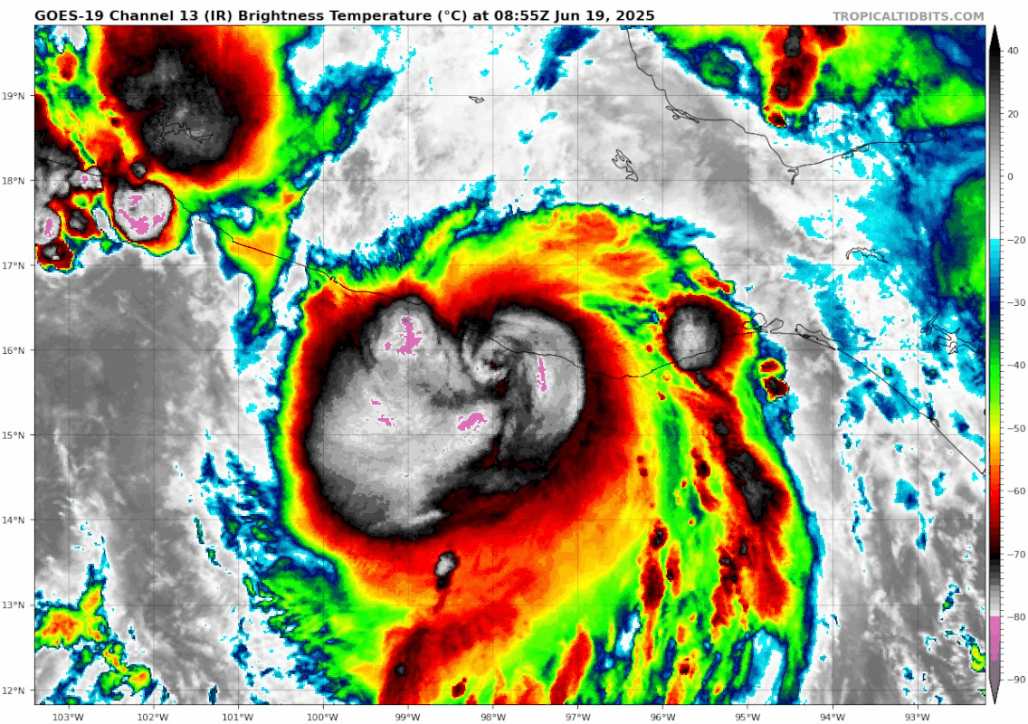
Re: EPAC: ERICK - Hurricane - Discussion: Makes landfall
BULLETIN
Hurricane Erick Intermediate Advisory Number 12A
NWS National Hurricane Center Miami FL EP052025
600 AM CST Thu Jun 19 2025
...MAJOR HURRICANE ERICK MAKES LANDFALL IN EXTREME WESTERN OAXACA
MEXICO...
SUMMARY OF 600 AM CST...1200 UTC...INFORMATION
----------------------------------------------
LOCATION...16.3N 98.3W
ABOUT 20 MI...30 KM E OF PUNTA MALDONADO MEXICO
MAXIMUM SUSTAINED WINDS...125 MPH...205 KM/H
PRESENT MOVEMENT...NW OR 310 DEGREES AT 9 MPH...15 KM/H
MINIMUM CENTRAL PRESSURE...950 MB...28.05 INCHES
0 likes
Visit the Caribbean-Central America Weather Thread where you can find at first post web cams,radars
and observations from Caribbean basin members Click Here
and observations from Caribbean basin members Click Here

Re: EPAC: ERICK - Hurricane - Discussion: Makes landfall
Erick occupies a shared #12th place for the strongest (by wind speed) landfall in Mexico from the Pacific. In terms of landfall pressure it has a shared #8th place. It is also the first MH landfall in Mexico in June (from the EPAC or the NATL). Based on the NOAA hurricane database these below are all MH landfalls in Mexico from the Pacific.
# / Storm / Year / Landfall wind speed (kt) / Landfall pressure (mb)
1 / Otis / 2023 / 140 kt / 929 mb
2 / Patricia / 2015 / 130 kt / 932 mb
3 / Madeline / 1976 / 125 kt / 940 mb
7 / Lidia / 2023 / 120 kt / 942 mb
7 / Kenna / 2002 / 120 kt / 950 mb
7 / Unnamed / 1959 / 120 kt / 955 mb
7 / Unnamed / 1957 / 120 kt / 959 mb
12 / Olivia / 1967 / 110 kt / 939 mb
12 / Odile / 2014 / 110 kt / 941 mb
12 / Erick / 2025 / 110 kt / 950 mb
12 / Lane / 2006 / 110 kt / 954 mb
12 / Tico / 1983 / 110 kt / ? mb
14 / John / 2024 / 105 kt / 956 mb
14 / Roslyn / 2022 / 105 kt / 961 mb
18 / Kiko / 1989 / 100 kt / 960 mb
18 / Willa / 2018 / 100 kt / 968 mb
18 / Liza / 1976 / 100 kt / ? mb
18 / Olivia / 1975 / 100 kt / ? mb
5 likes
-
cycloneye
- Admin
- Posts: 149807
- Age: 69
- Joined: Thu Oct 10, 2002 10:54 am
- Location: San Juan, Puerto Rico
Re: EPAC: ERICK - Hurricane - Discussion: Makes landfall
0 likes
Visit the Caribbean-Central America Weather Thread where you can find at first post web cams,radars
and observations from Caribbean basin members Click Here
and observations from Caribbean basin members Click Here
-
cycloneye
- Admin
- Posts: 149807
- Age: 69
- Joined: Thu Oct 10, 2002 10:54 am
- Location: San Juan, Puerto Rico
Re: EPAC: ERICK - Hurricane - Discussion: Makes landfall
The intensity is going down but the copious rains will continue to affect Oaxaca, Guerrero and other Mexican states. Here are webcams from Acapulco.
https://webcamsdemexico.com/webcams/en/acapulco/

https://webcamsdemexico.com/webcams/en/acapulco/
0 likes
Visit the Caribbean-Central America Weather Thread where you can find at first post web cams,radars
and observations from Caribbean basin members Click Here
and observations from Caribbean basin members Click Here
-
cycloneye
- Admin
- Posts: 149807
- Age: 69
- Joined: Thu Oct 10, 2002 10:54 am
- Location: San Juan, Puerto Rico
Re: EPAC: ERICK - Hurricane - Discussion
1 likes
Visit the Caribbean-Central America Weather Thread where you can find at first post web cams,radars
and observations from Caribbean basin members Click Here
and observations from Caribbean basin members Click Here
-
cycloneye
- Admin
- Posts: 149807
- Age: 69
- Joined: Thu Oct 10, 2002 10:54 am
- Location: San Juan, Puerto Rico
Re: EPAC: ERICK - Hurricane - Discussion
BULLETIN
Hurricane Erick Advisory Number 13
NWS National Hurricane Center Miami FL EP052025
900 AM CST Thu Jun 19 2025
...HURRICANE ERICK MOVING INLAND OVER SOUTHERN MEXICO...
...FLOODING RAINS AND HURRICANE-FORCE WINDS CONTINUE...
SUMMARY OF 900 AM CST...1500 UTC...INFORMATION
----------------------------------------------
LOCATION...16.7N 98.8W
ABOUT 30 MI...50 KM NNW OF PUNTA MALDONADO MEXICO
MAXIMUM SUSTAINED WINDS...85 MPH...140 KM/H
PRESENT MOVEMENT...NW OR 310 DEGREES AT 12 MPH...19 KM/H
MINIMUM CENTRAL PRESSURE...980 MB...28.94 INCHES
WATCHES AND WARNINGS
--------------------
CHANGES WITH THIS ADVISORY:
The government of Mexico has discontinued all warnings east of
Puerto Escondido and discontinued the Hurricane Watch west of
Acapulco to Tecpan de Galeana.
0 likes
Visit the Caribbean-Central America Weather Thread where you can find at first post web cams,radars
and observations from Caribbean basin members Click Here
and observations from Caribbean basin members Click Here
-
Yellow Evan
- Professional-Met
- Posts: 16257
- Age: 27
- Joined: Fri Jul 15, 2011 12:48 pm
- Location: Henderson, Nevada/Honolulu, HI
- Contact:
Re: EPAC: ERICK - Hurricane - Discussion
I'd suggest one takes intensity records with a degree of caution in any non-recon basin, given how often estimates back prior to 1995 or so don't seem to line up with modern practices, especially here given how much more active the base state generally was for TCs in the 80s and early 90s.
3 likes
-
galaxy401

- Category 5

- Posts: 2446
- Age: 30
- Joined: Sat Aug 25, 2012 9:04 pm
- Location: Casa Grande, Arizona
Re: EPAC: ERICK - Hurricane - Discussion
Honestly, I'm not sure this was a major at landfall. The inner core really degraded before landfall (I argue it already was starting to weaken when it was upgraded to Cat 4).
0 likes
Got my eyes on moving right into Hurricane Alley: Florida.
-
cycloneye
- Admin
- Posts: 149807
- Age: 69
- Joined: Thu Oct 10, 2002 10:54 am
- Location: San Juan, Puerto Rico
Re: EPAC: ERICK - Hurricane - Discussion
galaxy401 wrote:Honestly, I'm not sure this was a major at landfall. The inner core really degraded before landfall (I argue it already was starting to weaken when it was upgraded to Cat 4).
For sure, we will have the final data when the TCR comes out.
0 likes
Visit the Caribbean-Central America Weather Thread where you can find at first post web cams,radars
and observations from Caribbean basin members Click Here
and observations from Caribbean basin members Click Here

Re: EPAC: ERICK - Hurricane - Discussion
I am seeing some images/video supposedly taken in the area consistent with the passage of a strong hurricane, but I don't have any way of confirming them.
https://x.com/rioaxaca/status/193573007 ... 7pGUekQgEQ
https://x.com/951mx_com/status/19357098 ... 7pGUekQgEQ
https://x.com/rioaxaca/status/193573007 ... 7pGUekQgEQ
https://x.com/951mx_com/status/19357098 ... 7pGUekQgEQ
0 likes
-
cycloneye
- Admin
- Posts: 149807
- Age: 69
- Joined: Thu Oct 10, 2002 10:54 am
- Location: San Juan, Puerto Rico
Re: EPAC: ERICK - Hurricane - Discussion
0 likes
Visit the Caribbean-Central America Weather Thread where you can find at first post web cams,radars
and observations from Caribbean basin members Click Here
and observations from Caribbean basin members Click Here
-
Astromanía
- Category 3

- Posts: 801
- Age: 27
- Joined: Sat Aug 25, 2018 10:34 pm
- Location: Monterrey, N.L, México
Re: EPAC: ERICK - Hurricane - Discussion
The oblique track weakens hurricanes that make landfall in mountainous terrain. That's why it's very important to have some barometric measurements on land to assess the intensity of the storm at landfall.
0 likes
-
cycloneye
- Admin
- Posts: 149807
- Age: 69
- Joined: Thu Oct 10, 2002 10:54 am
- Location: San Juan, Puerto Rico
Re: EPAC: ERICK - Hurricane - Discussion
BULLETIN
Hurricane Erick Intermediate Advisory Number 13A
NWS National Hurricane Center Miami FL EP052025
1200 PM CST Thu Jun 19 2025
...HURRICANE ERICK MOVING INLAND OVER SOUTHERN MEXICO...
...FLOODING RAINS CONTINUE...
SUMMARY OF 1200 PM CST...1800 UTC...INFORMATION
-----------------------------------------------
LOCATION...17.1N 99.0W
ABOUT 60 MI...100 KM NNW OF PUNTA MALDONADO MEXICO
ABOUT 60 MI...100 KM ENE OF ACAPULCO MEXICO
MAXIMUM SUSTAINED WINDS...75 MPH...120 KM/H
PRESENT MOVEMENT...NW OR 310 DEGREES AT 12 MPH...19 KM/H
MINIMUM CENTRAL PRESSURE...988 MB...29.18 INCHES
0 likes
Visit the Caribbean-Central America Weather Thread where you can find at first post web cams,radars
and observations from Caribbean basin members Click Here
and observations from Caribbean basin members Click Here
-
weeniepatrol

- Category 5
- Posts: 1345
- Joined: Sat Aug 22, 2020 5:30 pm
- Location: WA State
Re: EPAC: ERICK - Hurricane - Discussion
Yellow Evan wrote:Not sure this ever had the time to strengthen into Category 4 given the eyewall replacement cycle earlier but there’s at least a case now that the microwave suggested just one eyewall at 6z. This is a hot take admittedly given all the estimates supported >=115 knots at 6z.
That is a hot take. It is true that microwave suggested internal fluctuations for a lengthy period of time there, but eh pressure (as measured by recon in the 950s) and pressure gradient definitely makes me lean towards C4 peak
1 likes
-
cycloneye
- Admin
- Posts: 149807
- Age: 69
- Joined: Thu Oct 10, 2002 10:54 am
- Location: San Juan, Puerto Rico
Re: EPAC: ERICK - Tropical Storm - Discussion
BULLETIN
Tropical Storm Erick Advisory Number 14
NWS National Hurricane Center Miami FL EP052025
300 PM CST Thu Jun 19 2025
...ERICK WEAKENS TO A TROPICAL STORM...
...FLOODING RAINS CONTINUE...
SUMMARY OF 300 PM CST...2100 UTC...INFORMATION
----------------------------------------------
LOCATION...17.4N 99.7W
ABOUT 35 MI...60 KM NNE OF ACAPULCO MEXICO
MAXIMUM SUSTAINED WINDS...50 MPH...85 KM/H
PRESENT MOVEMENT...NW OR 310 DEGREES AT 12 MPH...19 KM/H
MINIMUM CENTRAL PRESSURE...1000 MB...29.53 INCHES
0 likes
Visit the Caribbean-Central America Weather Thread where you can find at first post web cams,radars
and observations from Caribbean basin members Click Here
and observations from Caribbean basin members Click Here
-
cycloneye
- Admin
- Posts: 149807
- Age: 69
- Joined: Thu Oct 10, 2002 10:54 am
- Location: San Juan, Puerto Rico
Re: EPAC: ERICK - Tropical Depression - Discussion
BULLETIN
Tropical Depression Erick Intermediate Advisory Number 14A
NWS National Hurricane Center Miami FL EP052025
600 PM CST Thu Jun 19 2025
...ERICK RAPIDLY WEAKENS TO A TROPICAL DEPRESSION...
...FLOODING RAINS CONTINUE...
SUMMARY OF 600 PM CST...0000 UTC...INFORMATION
----------------------------------------------
LOCATION...17.7N 100.2W
ABOUT 60 MI...95 KM NNW OF ACAPULCO MEXICO
MAXIMUM SUSTAINED WINDS...35 MPH...55 KM/H
PRESENT MOVEMENT...NW OR 310 DEGREES AT 12 MPH...19 KM/H
MINIMUM CENTRAL PRESSURE...1006 MB...29.71 INCHES
0 likes
Visit the Caribbean-Central America Weather Thread where you can find at first post web cams,radars
and observations from Caribbean basin members Click Here
and observations from Caribbean basin members Click Here
-
cycloneye
- Admin
- Posts: 149807
- Age: 69
- Joined: Thu Oct 10, 2002 10:54 am
- Location: San Juan, Puerto Rico
Re: EPAC: ERICK - Post-Tropical - Discussion
Hasta la vista Erick. 
BULLETIN
Post-Tropical Cyclone Erick Advisory Number 15
NWS National Hurricane Center Miami FL EP052025
900 PM CST Thu Jun 19 2025
...ERICK DECAYS TO A LOW PRESSURE AREA...
...THREAT OF FLOODING RAINS CONTINUES...
SUMMARY OF 900 PM CST...0300 UTC...INFORMATION
----------------------------------------------
LOCATION...18.0N 100.8W
ABOUT 95 MI...155 KM NW OF ACAPULCO MEXICO
MAXIMUM SUSTAINED WINDS...30 MPH...45 KM/H
PRESENT MOVEMENT...NW OR 310 DEGREES AT 13 MPH...20 KM/H
MINIMUM CENTRAL PRESSURE...1006 MB...29.71 INCHES
2 likes
Visit the Caribbean-Central America Weather Thread where you can find at first post web cams,radars
and observations from Caribbean basin members Click Here
and observations from Caribbean basin members Click Here
Who is online
Users browsing this forum: No registered users and 53 guests