
NATL: LORENZO - Remnants - Discussion
Moderator: S2k Moderators
Re: NATL: LORENZO - Tropical Storm - Discussion
Looking like a comma.
3 likes
TC naming lists: retirements and intensity
Most aggressive Advisory #1's in North Atlantic (cr. kevin for starting the list)
Most aggressive Advisory #1's in North Atlantic (cr. kevin for starting the list)
-
wxman57

- Moderator-Pro Met

- Posts: 23172
- Age: 68
- Joined: Sat Jun 21, 2003 8:06 pm
- Location: Houston, TX (southwest)
Re: NATL: LORENZO - Tropical Storm - Discussion
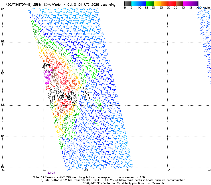
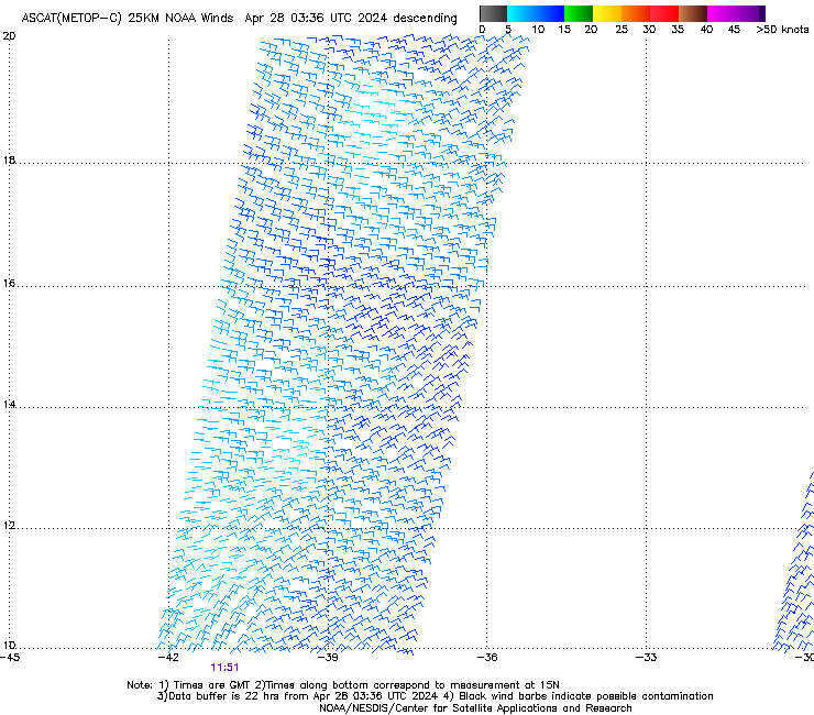
ASCAT from 1244Z indicates a wave axis. All models dissipate it tomorrow.
https://manati.star.nesdis.noaa.gov/ascat_images/cur_25km_METC/zooms/WMBds112.png
https://manati.star.nesdis.noaa.gov/ascat_images/cur_25km_METC/zooms/WMBds112.png
0 likes
-
DorkyMcDorkface

- Category 4

- Posts: 988
- Age: 28
- Joined: Mon Sep 30, 2019 1:32 pm
- Location: Mid-Atlantic
Re: NATL: LORENZO - Tropical Storm - Discussion
wxman57 wrote:ASCAT from 1244Z indicates a wave axis. All models dissipate it tomorrow.
https://manati.star.nesdis.noaa.gov/ascat_images/cur_25km_METC/zooms/WMBds112.png
Sure looks like a defined (partially exposed) circulation to me on vis:

3 likes
Please note the thougths expressed by this account are solely those of the user and are from a hobbyist perspective. For more comprehensive analysis, consult an actual professional meteorologist or meteorology agency.
Floyd 1999 | Isabel 2003 | Hanna 2008 | Irene 2011 | Sandy 2012 | Isaias 2020
-
wxman57
- Moderator-Pro Met
- Posts: 23172
- Age: 68
- Joined: Sat Jun 21, 2003 8:06 pm
- Location: Houston, TX (southwest)
Re: NATL: LORENZO - Tropical Storm - Discussion
DorkyMcDorkface wrote:wxman57 wrote:ASCAT from 1244Z indicates a wave axis. All models dissipate it tomorrow.
https://manati.star.nesdis.noaa.gov/ascat_images/cur_25km_METC/zooms/WMBds112.png
Sure looks like a defined (partially exposed) circulation to me on vis:
https://i.imgur.com/YqKn6tW.gif
Yeah, I saw the visible loop. It does look like a surface circulation. However, it looks terrible on IR imagery and all models indicate dissipation within 24 hrs.
0 likes

Re: NATL: LORENZO - Tropical Storm - Discussion
Models must be confusing the Greek Laurel with the storm since the Laurel is shaped like an open wave?
Low level circulation there now.
Low level circulation there now.
0 likes
-
cycloneye

- Admin

- Posts: 149275
- Age: 69
- Joined: Thu Oct 10, 2002 10:54 am
- Location: San Juan, Puerto Rico
Re: NATL: LORENZO - Tropical Storm - Discussion
Weakening? I guess not yet. 
AL, 12, 2025101400, , BEST, 0, 157N, 423W, 50, 999, TS
5 likes
Visit the Caribbean-Central America Weather Thread where you can find at first post web cams,radars
and observations from Caribbean basin members Click Here
and observations from Caribbean basin members Click Here


Re: NATL: LORENZO - Tropical Storm - Discussion
Excerpt from NHC Lorenzo Forecast Discussion:
Should be an interesting next couple of days.
The intensity forecast is quite challenging. An upper-level low
that has been shearing Lorenzo is forecast to drop to the
southwest, resulting in decreasing shear during the next couple of
days. This synoptic evolution is historically well known for
intensification given the recent formation of the small inner core
over warm waters. However, very dry air is present in the
environment, and Lorenzo should embed itself deep into a recent
Saharan Air Layer (SAL) outbreak to the north within a couple of
days. There are credible models that respond to these factors by
weakening this into a tropical depression in a few days, like the
HAFS-A/B, or a category 1/2 hurricane, like the HWRF/HMON. The new
forecast splits these extremes, ending up a bit higher than the
previous official forecast but near the HFIP Corrected Consensus
model HCCA. It should be emphasized that this is a low-confidence
prediction for all of the conditions listed above and the cyclone's
small size, making it susceptible to large upward or downward
changes in a short period of time.
Should be an interesting next couple of days.
2 likes
-
Sciencerocks
- Category 5

- Posts: 10181
- Age: 40
- Joined: Thu Jul 06, 2017 1:51 am

-
MarioProtVI
- Category 5
- Posts: 1034
- Age: 24
- Joined: Sun Sep 29, 2019 7:33 pm
- Location: New Jersey
Re: NATL: LORENZO - Tropical Storm - Discussion
Models seem to be having a difficult time with resolving Lorenzo because of its small size. I would personally throw out the models insisting this dissipates today because they are not resolving it well at all (especially the Euro which completely missed this in the first place).
3 likes
-
TomballEd
- Category 5
- Posts: 1263
- Age: 62
- Joined: Wed Aug 16, 2023 4:52 pm
- Location: Spring/Klein area, not Tomball
Re: NATL: LORENZO - Tropical Storm - Discussion
New hot tower going up very close to the LLC.

0 likes
-
wxman57
- Moderator-Pro Met
- Posts: 23172
- Age: 68
- Joined: Sat Jun 21, 2003 8:06 pm
- Location: Houston, TX (southwest)
Re: NATL: LORENZO - Tropical Storm - Discussion
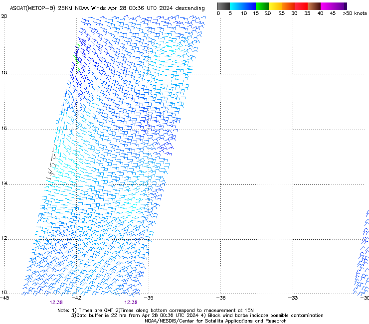
Got a partial ASCAT-B descending pass hit at 1230Z today. No 35kt wind in eastern half. This is not a 50kt TS. May not even have any 35kt wind. All models still dissipate it within 24 hours.
https://manati.star.nesdis.noaa.gov/ascat_images/cur_25km_METB/zooms/WMBds112.png
https://manati.star.nesdis.noaa.gov/ascat_images/cur_25km_METB/zooms/WMBds112.png
1 likes
-
wxman57
- Moderator-Pro Met
- Posts: 23172
- Age: 68
- Joined: Sat Jun 21, 2003 8:06 pm
- Location: Houston, TX (southwest)
Re: NATL: LORENZO - Tropical Storm - Discussion
MarioProtVI wrote:Models seem to be having a difficult time with resolving Lorenzo because of its small size. I would personally throw out the models insisting this dissipates today because they are not resolving it well at all (especially the Euro which completely missed this in the first place).
I think that the Euro initialized it best at 30 kts. GFS had 50 kts. It's a lot closer to 30 kts than 50 kts.
1 likes
-
Sciencerocks
- Category 5
- Posts: 10181
- Age: 40
- Joined: Thu Jul 06, 2017 1:51 am


-
AnnularCane

- S2K Supporter

- Posts: 2957
- Joined: Thu Jun 08, 2006 9:18 am
- Location: Wytheville, VA
Re: NATL: LORENZO - Tropical Storm - Discussion
He was supposed to have a fun little dance around the Atlantic. 
3 likes
"But it never rained rain. It never snowed snow. And it never blew just wind. It rained things like soup and juice. It snowed mashed potatoes and green peas. And sometimes the wind blew in storms of hamburgers." -- Judi Barrett, Cloudy with a Chance of Meatballs
-
wxman57
- Moderator-Pro Met
- Posts: 23172
- Age: 68
- Joined: Sat Jun 21, 2003 8:06 pm
- Location: Houston, TX (southwest)
Re: NATL: LORENZO - Tropical Storm - Discussion
Best track at 18Z now lists it as a TD. NHC could well issue a final this afternoon or this evening. I know, nobody cares...
2 likes
-
cycloneye
- Admin
- Posts: 149275
- Age: 69
- Joined: Thu Oct 10, 2002 10:54 am
- Location: San Juan, Puerto Rico
Re: NATL: LORENZO - Remnants - Discussion
Bye.
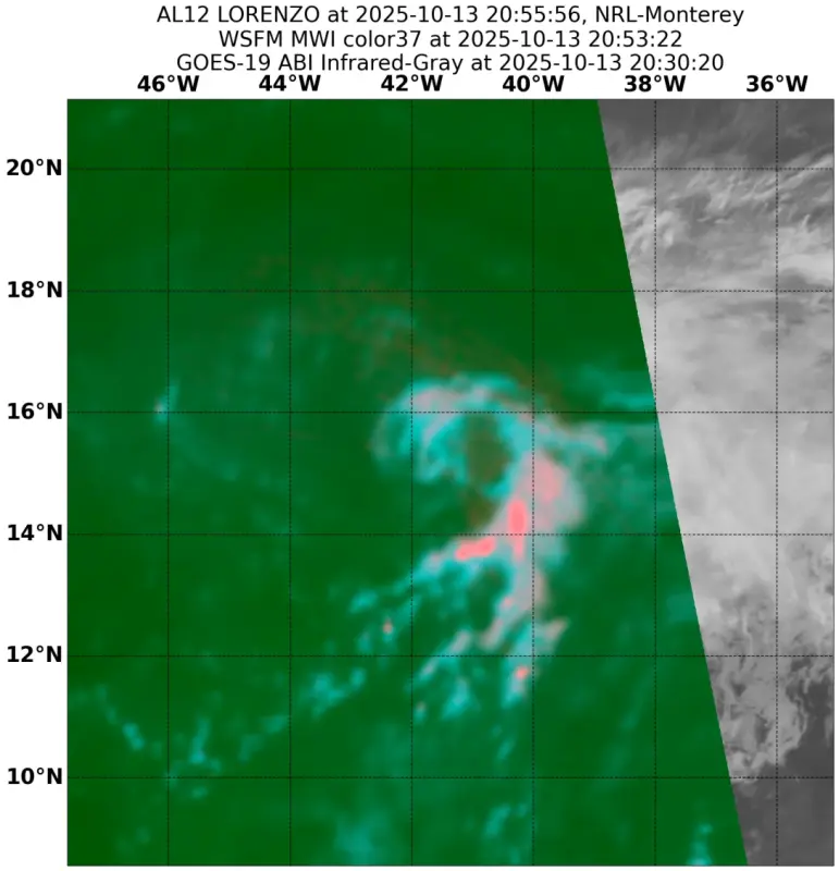
Visible satellite imagery shows that Lorenzo no longer has a
well-defined circulation and has dissipated. Recent microwave
imagery also suggested that the system had opened to its west.
well-defined circulation and has dissipated. Recent microwave
imagery also suggested that the system had opened to its west.
3 likes
Visit the Caribbean-Central America Weather Thread where you can find at first post web cams,radars
and observations from Caribbean basin members Click Here
and observations from Caribbean basin members Click Here
Who is online
Users browsing this forum: No registered users and 178 guests