ATL: MILTON - Models

Moderator: S2k Moderators

Message
Author
User avatar
Steve
S2K Supporter
S2K Supporter
Posts: 9621
Joined: Sat Apr 05, 2003 11:41 pm
Location: Not a state-caster

Re: ATL: MILTON - Models

#861 Postby Steve » Mon Oct 07, 2024 2:55 pm

SouthFLTropics wrote:
HurricaneBelle wrote:
MEANINGLESS_NUMBERS wrote:
So... right into the mouth of the bay? In terms of surge that might actually be worse.


Bradenton and Sarasota are south of Tampa Bay (the body of water), the winds would be offshore over the bay as a result (but still Cat 3 or worse) but surge would be alleviated.


Surge would definitely be lessened but not eliminated. This is going to push a bunch of water out ahead of it and some of that is going to stack into the bay no matter what. If the center makes landfall south of the bay, an easterly wind would still likely push quite a bit of water into the east side of St. Petersburg.


Definitely true. I've only driven around down in Sarasota and Bradenton, but you already know there's way more there than just Tampa Bay north of Palma Sola. There are tons of inlets, rivers bays, etc. that are south of Tampa Bay that would get the massive surge. Manatee River (Bradenton), Palma Sola Bay, Lyons Bay, Sarasota Bay, Roberts Bay, Little Sarasota Bay, Charlotte Harbor, Dryman Bay, etc. And there are some really exclusive residences near and on the water and tons and tons and tons and tons of boats. And that's not to mention the barrier islands, many of which got smacked in Helene. So all those communities south of Tampa Bay from the Venice Inlet up to Anna Maria Island could get wrecked (talking Siesta Key, Sarasota Beach, Lido Key, Longboat Key, Bradenton Beach, Holmes, etc.)
2 likes   

jdjaguar
Category 2
Category 2
Posts: 551
Joined: Fri Aug 26, 2005 12:07 pm
Location: Jacksonville Beach, FL

Re: ATL: MILTON - Models

#862 Postby jdjaguar » Mon Oct 07, 2024 3:40 pm

snownado wrote:
Steve wrote:Something else you won't see for a pending landfalling hurricane in the US very often. Early-cycle intensity guidance for 18z

https://hurricanes.ral.ucar.edu/realtime/plots/northatlantic/2024/al142024/intensity_early/aal14_2024100718_intensity_early.png


The scaling on that chart is a bit off.

Current projections, for what they're worth, are a Cat 3 at landfall.

125mph CAT3 which is 5mph less than CAT4
1 likes   

User avatar
SFLcane
S2K Supporter
S2K Supporter
Posts: 10163
Age: 47
Joined: Sat Jun 05, 2010 1:44 pm
Location: Lake Worth Florida

Re: ATL: MILTON - Models

#863 Postby SFLcane » Mon Oct 07, 2024 3:41 pm

1 likes   

KC7NEC
Tropical Storm
Tropical Storm
Posts: 162
Joined: Wed Oct 05, 2016 12:01 am

Re: ATL: MILTON - Models

#864 Postby KC7NEC » Mon Oct 07, 2024 3:59 pm

jdjaguar wrote:
snownado wrote:
Steve wrote:Something else you won't see for a pending landfalling hurricane in the US very often. Early-cycle intensity guidance for 18z

https://hurricanes.ral.ucar.edu/realtime/plots/northatlantic/2024/al142024/intensity_early/aal14_2024100718_intensity_early.png


The scaling on that chart is a bit off.

Current projections, for what they're worth, are a Cat 3 at landfall.

125mph CAT3 which is 5mph less than CAT4


The storm is still pushing a powerful Cat 5-level surge, which is by far the bigger threat. What worries me most is that people will see the storm “weakening to a Cat 3” by landfall and mistakenly take it as a sign that it’s safe, when that couldn’t be further from the truth. The focus needs to be on the surge and flooding potential, not just the wind speed category. This is why I’m eager for the day when the NHC finally shifts away from using the Saffir-Simpson Scale and Cone and moves toward an Impact-Based system that actually communicates the full range of dangers a storm like this can bring. Until then, I’m afraid too many people will continue to underestimate storms just because they don’t understand what the “category” truly represents.
4 likes   
// Opinions are my own, I am not a Meteorologist. Consult the NHC or Local NWS and Emergency Management for current information in your area. //

MrJames
Tropical Storm
Tropical Storm
Posts: 189
Joined: Fri Sep 10, 2004 11:56 am
Location: Jax, FL

Re: ATL: MILTON - Models

#865 Postby MrJames » Mon Oct 07, 2024 4:08 pm

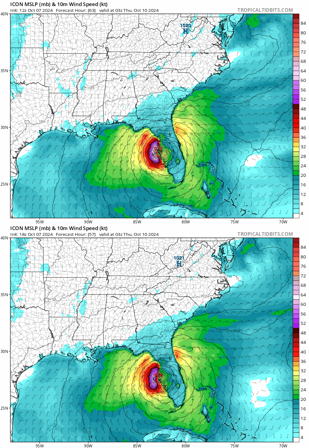
18z Icon
Image
0 likes   

Weathertracker96
Tropical Storm
Tropical Storm
Posts: 104
Joined: Mon Oct 16, 2023 3:41 pm

Re: ATL: MILTON - Models

#866 Postby Weathertracker96 » Mon Oct 07, 2024 4:13 pm

MrJames wrote:18z Icon
https://i.imgur.com/7niCgQD.gif

Is that the same location as the 12z run?
0 likes   

fllawyer
Tropical Depression
Tropical Depression
Posts: 78
Joined: Wed Aug 28, 2019 11:45 am

Re: ATL: MILTON - Models

#867 Postby fllawyer » Mon Oct 07, 2024 4:15 pm

Weathertracker96 wrote:
MrJames wrote:18z Icon
https://i.imgur.com/7niCgQD.gif

Is that the same location as the 12z run?


Looks slightly S of 12Z but hard to tell.
0 likes   

MrJames
Tropical Storm
Tropical Storm
Posts: 189
Joined: Fri Sep 10, 2004 11:56 am
Location: Jax, FL

Re: ATL: MILTON - Models

#868 Postby MrJames » Mon Oct 07, 2024 4:16 pm

Weathertracker96 wrote:
MrJames wrote:18z Icon
https://i.imgur.com/7niCgQD.gif

Is that the same location as the 12z run?


18z Icon
Image

12z Icon
Image

Slightly south
1 likes   

Weathertracker96
Tropical Storm
Tropical Storm
Posts: 104
Joined: Mon Oct 16, 2023 3:41 pm

Re: ATL: MILTON - Models

#869 Postby Weathertracker96 » Mon Oct 07, 2024 4:19 pm

MrJames wrote:
Weathertracker96 wrote:
MrJames wrote:18z Icon
https://i.imgur.com/7niCgQD.gif

Is that the same location as the 12z run?


18z Icon
https://i.imgur.com/7niCgQD.gif

12z Icon
https://i.imgur.com/1vEFeRJ.gif

Slightly south


Interesting to see a slight south shift.Thanks for posting.
0 likes   

skillz305
Category 1
Category 1
Posts: 279
Joined: Sat Sep 08, 2018 11:10 am
Location: Miami, Florida --> Vero Beach, Florida

Re: ATL: MILTON - Models

#870 Postby skillz305 » Mon Oct 07, 2024 4:20 pm

Weathertracker96 wrote:
MrJames wrote:18z Icon
https://i.imgur.com/7niCgQD.gif

Is that the same location as the 12z run?


12z location for comparison

Image
2 likes   
:flag:Hurricanes: Andrew 1992 - Irene 1999 - Frances 2004 - Jeanne 2004 - Katrina 2005 - Wilma 2005 - Matthew 2016 - Irma 2017 - Ian 2022 - Nicole 2022 - Milton 2024

jhpigott
Category 2
Category 2
Posts: 570
Joined: Wed Jan 02, 2008 8:09 pm
Location: North Palm Beach, Florida

Re: ATL: MILTON - Models

#871 Postby jhpigott » Mon Oct 07, 2024 4:20 pm

MrJames wrote:
Weathertracker96 wrote:
MrJames wrote:18z Icon
https://i.imgur.com/7niCgQD.gif

Is that the same location as the 12z run?


18z Icon
https://i.imgur.com/7niCgQD.gif

12z Icon
https://i.imgur.com/1vEFeRJ.gif

Slightly south


Looks quite a bit south on the exit off the east coast of FL. Sitting here just a couple miles SW of the Jupiter Inlet, I think our impacts could be quite a bit worse if this comes off the east coast closer to Vero Beach as opposed to Cape Canaveral
2 likes   

skillz305
Category 1
Category 1
Posts: 279
Joined: Sat Sep 08, 2018 11:10 am
Location: Miami, Florida --> Vero Beach, Florida

Re: ATL: MILTON - Models

#872 Postby skillz305 » Mon Oct 07, 2024 4:24 pm

jhpigott wrote:
MrJames wrote:
Weathertracker96 wrote:Is that the same location as the 12z run?


18z Icon
https://i.imgur.com/7niCgQD.gif

12z Icon
https://i.imgur.com/1vEFeRJ.gif

Slightly south


Looks quite a bit south on the exit off the east coast of FL. Sitting here just a couple miles SW of the Jupiter Inlet, I think our impacts could be quite a bit worse if this comes off the east coast closer to Vero Beach as opposed to Cape Canaveral


Vero here... was def watching all day if any south trends and here we are :double: ICON has done very well in the gulf in recent past. Euro also trended a tad south. The 18z guidance models tightened up which seemed a bit south. Here we are. Looking at some cat 1 hurricane type effects over Vero if this plays out.
2 likes   
:flag:Hurricanes: Andrew 1992 - Irene 1999 - Frances 2004 - Jeanne 2004 - Katrina 2005 - Wilma 2005 - Matthew 2016 - Irma 2017 - Ian 2022 - Nicole 2022 - Milton 2024

User avatar
blp
Category 5
Category 5
Posts: 2840
Age: 46
Joined: Thu Sep 09, 2004 7:51 pm
Location: Miami, FL
Contact:

Re: ATL: MILTON - Models

#873 Postby blp » Mon Oct 07, 2024 4:24 pm

MrJames wrote:
Weathertracker96 wrote:
MrJames wrote:18z Icon
https://i.imgur.com/7niCgQD.gif

Is that the same location as the 12z run?


18z Icon
https://i.imgur.com/7niCgQD.gif

12z Icon
https://i.imgur.com/1vEFeRJ.gif

Slightly south


The exit of the state is much further south.

Image
Last edited by blp on Mon Oct 07, 2024 4:30 pm, edited 1 time in total.
0 likes   
The following post is NOT an official forecast and should not be used as such. It is just the opinion of the poster and may or may not be backed by sound meteorological data. It is NOT endorsed by any professional institution including storm2k.org For Official Information please refer to the NHC and NWS products.

Weathertracker96
Tropical Storm
Tropical Storm
Posts: 104
Joined: Mon Oct 16, 2023 3:41 pm

Re: ATL: MILTON - Models

#874 Postby Weathertracker96 » Mon Oct 07, 2024 4:25 pm

jhpigott wrote:
MrJames wrote:
Weathertracker96 wrote:Is that the same location as the 12z run?


18z Icon
https://i.imgur.com/7niCgQD.gif

12z Icon
https://i.imgur.com/1vEFeRJ.gif

Slightly south


Looks quite a bit south on the exit off the east coast of FL. Sitting here just a couple miles SW of the Jupiter Inlet, I think our impacts could be quite a bit worse if this comes off the east coast closer to Vero Beach as opposed to Cape Canaveral


I agree. It’ll be interesting to see what the other models do. Since Vero is under a hurricane watch now, I’m going to put up shutters. That possible right hook after landfall is concerning.
0 likes   

User avatar
NDG
S2K Supporter
S2K Supporter
Posts: 15446
Joined: Sun Jul 09, 2006 10:14 pm
Location: Orlando, FL

Re: ATL: MILTON - Models

#875 Postby NDG » Mon Oct 07, 2024 4:30 pm

18z ICON
Was looking at Ian's model archives, about 48 hrs from landfall is when the UKMENT and ICON were persistent in landfall near Ft Meyer's area while the rest of the models were near Tampa Bay.

Image
2 likes   

User avatar
CronkPSU
S2K Supporter
S2K Supporter
Posts: 2014
Joined: Sun Aug 07, 2005 10:44 pm
Location: Avalon Park, FL

Re: ATL: MILTON - Models

#876 Postby CronkPSU » Mon Oct 07, 2024 4:41 pm

18z GFS just started running...let's see if we have any changes
1 likes   
Just like Jon Snow..."I know nothing" except what I know, and most of what I know is gathered by the fine people of the NHC

User avatar
JtSmarts
S2K Supporter
S2K Supporter
Posts: 1437
Age: 39
Joined: Thu Jul 10, 2003 1:29 pm
Location: Columbia, South Carolina

Re: ATL: MILTON - Models

#877 Postby JtSmarts » Mon Oct 07, 2024 4:49 pm

Icon and GFS initialized way high with the pressure, not sure if that actually ends up affecting the outcome.
0 likes   

skillz305
Category 1
Category 1
Posts: 279
Joined: Sat Sep 08, 2018 11:10 am
Location: Miami, Florida --> Vero Beach, Florida

Re: ATL: MILTON - Models

#878 Postby skillz305 » Mon Oct 07, 2024 4:50 pm

CronkPSU wrote:18z GFS just started running...let's see if we have any changes


But how can we trust this run if its initiating point has it at a 982mb Hurricane? Real question.
2 likes   
:flag:Hurricanes: Andrew 1992 - Irene 1999 - Frances 2004 - Jeanne 2004 - Katrina 2005 - Wilma 2005 - Matthew 2016 - Irma 2017 - Ian 2022 - Nicole 2022 - Milton 2024

User avatar
CronkPSU
S2K Supporter
S2K Supporter
Posts: 2014
Joined: Sun Aug 07, 2005 10:44 pm
Location: Avalon Park, FL

Re: ATL: MILTON - Models

#879 Postby CronkPSU » Mon Oct 07, 2024 4:52 pm

unless it makes a real quick right turn...looks like it will be right over tampa again
0 likes   
Just like Jon Snow..."I know nothing" except what I know, and most of what I know is gathered by the fine people of the NHC

User avatar
CronkPSU
S2K Supporter
S2K Supporter
Posts: 2014
Joined: Sun Aug 07, 2005 10:44 pm
Location: Avalon Park, FL

Re: ATL: MILTON - Models

#880 Postby CronkPSU » Mon Oct 07, 2024 4:53 pm

skillz305 wrote:
CronkPSU wrote:18z GFS just started running...let's see if we have any changes


But how can we trust this run if its initiating point has it at a 982mb Hurricane? Real question.


every run is like this...and we hear people ask that every storm and doesn't make a difference with both GFS and Euro
0 likes   
Just like Jon Snow..."I know nothing" except what I know, and most of what I know is gathered by the fine people of the NHC


Return to “2024”

Who is online

Users browsing this forum: No registered users and 2 guests