ATL: HELENE - Models

Moderator: S2k Moderators

Message
Author
caneman
Category 5
Category 5
Posts: 1447
Joined: Fri Sep 05, 2014 5:44 am
Location: Clearwater Beach, Fl

Re: ATL: HELENE - Models

#761 Postby caneman » Wed Sep 25, 2024 4:39 pm

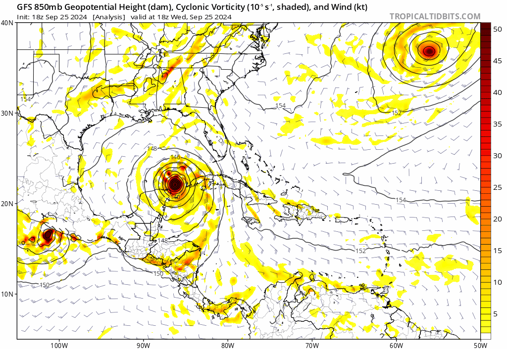
Poonwalker wrote:Bloody Icon. That hair shift east is putting some core effects into the west coast surge. That’s the problem with this track angle and also the intensity which is likely going to be higher than 947 mb. Can’t let your guard down on this one.


100%, even a 1/2 degree closer to the Tampa Bay area means higher end surge and even more wind.
0 likes   

tolakram
Admin
Admin
Posts: 20009
Age: 62
Joined: Sun Aug 27, 2006 8:23 pm
Location: Florence, KY (name is Mark)

Re: ATL: HELENE - Models

#762 Postby tolakram » Wed Sep 25, 2024 4:40 pm

12z euro
Image

Trend
Image
2 likes   
M a r k
- - - - -
Join us in chat: Storm2K Chatroom Invite. Android and IOS apps also available.

The posts in this forum are NOT official forecasts and should not be used as such. Posts are NOT endorsed by any professional institution or STORM2K.org. For official information and forecasts, please refer to NHC and NWS products.

Lance
Tropical Low
Tropical Low
Posts: 26
Joined: Fri Jul 24, 2020 11:35 am
Location: Kissimmee, FL

Re: ATL: HELENE - Models

#763 Postby Lance » Wed Sep 25, 2024 4:44 pm


East trend? Can’t tell on my phone.
0 likes   

User avatar
Bocadude85
Category 5
Category 5
Posts: 2991
Age: 38
Joined: Mon Apr 18, 2005 2:20 pm
Location: Honolulu,Hi

Re: ATL: HELENE - Models

#764 Postby Bocadude85 » Wed Sep 25, 2024 4:57 pm

18z GFS also trended a bit east, especially in the 24-30 hour timeframe
1 likes   

User avatar
Travorum
Category 1
Category 1
Posts: 406
Joined: Tue Sep 05, 2023 9:36 am
Location: Dunedin, FL

Re: ATL: HELENE - Models

#765 Postby Travorum » Wed Sep 25, 2024 4:59 pm

18z GFS

Image

Trend

Image
0 likes   

FLLurker32
Tropical Storm
Tropical Storm
Posts: 245
Joined: Mon Aug 29, 2016 10:31 am

Re: ATL: HELENE - Models

#766 Postby FLLurker32 » Wed Sep 25, 2024 5:04 pm

Bocadude85 wrote:18z GFS also trended a bit east, especially in the 24-30 hour timeframe


That approach is horrible. It scrapes the west coast before landfall. The amount of water it would push up into Tampa Bay and Cedar key would be horrific.
0 likes   
Heather

tolakram
Admin
Admin
Posts: 20009
Age: 62
Joined: Sun Aug 27, 2006 8:23 pm
Location: Florence, KY (name is Mark)

Re: ATL: HELENE - Models

#767 Postby tolakram » Wed Sep 25, 2024 5:07 pm

18Z GFS
Image

Ends up just south of me
1 likes   
M a r k
- - - - -
Join us in chat: Storm2K Chatroom Invite. Android and IOS apps also available.

The posts in this forum are NOT official forecasts and should not be used as such. Posts are NOT endorsed by any professional institution or STORM2K.org. For official information and forecasts, please refer to NHC and NWS products.

User avatar
Bocadude85
Category 5
Category 5
Posts: 2991
Age: 38
Joined: Mon Apr 18, 2005 2:20 pm
Location: Honolulu,Hi

Re: ATL: HELENE - Models

#768 Postby Bocadude85 » Wed Sep 25, 2024 5:08 pm

FLLurker32 wrote:
Bocadude85 wrote:18z GFS also trended a bit east, especially in the 24-30 hour timeframe


That approach is horrible. It scrapes the west coast before landfall. The amount of water it would push up into Tampa Bay and Cedar key would be horrific.


Yes if it was to follow that exact track it would be quite a surge event from Tampa northward.
Last edited by Bocadude85 on Wed Sep 25, 2024 5:09 pm, edited 1 time in total.
1 likes   

tolakram
Admin
Admin
Posts: 20009
Age: 62
Joined: Sun Aug 27, 2006 8:23 pm
Location: Florence, KY (name is Mark)

Re: ATL: HELENE - Models

#769 Postby tolakram » Wed Sep 25, 2024 5:09 pm

Total precip
Image
0 likes   
M a r k
- - - - -
Join us in chat: Storm2K Chatroom Invite. Android and IOS apps also available.

The posts in this forum are NOT official forecasts and should not be used as such. Posts are NOT endorsed by any professional institution or STORM2K.org. For official information and forecasts, please refer to NHC and NWS products.

jlauderdal
S2K Supporter
S2K Supporter
Posts: 7182
Joined: Wed May 19, 2004 5:46 am
Location: NE Fort Lauderdale
Contact:

Re: ATL: HELENE - Models

#770 Postby jlauderdal » Wed Sep 25, 2024 5:17 pm

tolakram wrote:Total precip
Image
I already had 1.1 today so probably underdone at least in our area.
0 likes   

User avatar
SoupBone
Category 5
Category 5
Posts: 3111
Joined: Tue Sep 20, 2005 5:24 pm

Re: ATL: HELENE - Models

#771 Postby SoupBone » Wed Sep 25, 2024 5:38 pm

tolakram wrote:18Z GFS
https://i.imgur.com/EtdjBAR.gif

Ends up just south of me


What's interesting about that run, is that the official forecast ends up with Helene over Nashville, sitting. That run would be quite different.
0 likes   
Personal Forecast Disclaimer:
The posts in this forum are NOT official forecast and should not be used as such. They are just the opinion of the poster and may or may not be backed by sound meteorological data. They are NOT endorsed by any professional institution or storm2k.org. For official information, please refer to the NHC and NWS products.

User avatar
ronjon
Category 5
Category 5
Posts: 4822
Joined: Fri Aug 19, 2005 5:17 pm
Location: Hernando Beach, FL

Re: ATL: HELENE - Models

#772 Postby ronjon » Wed Sep 25, 2024 6:30 pm

I'm scratching my head on the NHC landfall position the last 12 hours. Some of our best models: Euro, Euro-AI, GFS, and ICON are all pointing toward a Taylor or Dixie county landfall yet NHC has slowing been shifting landfall slightly west each advisory now just east of Apalachicola. They must be weighting the hurricane model suite and CMC in their projections is best I can figure.
1 likes   

USTropics
Professional-Met
Professional-Met
Posts: 2646
Joined: Sun Aug 12, 2007 3:45 am
Location: Florida State University

Re: ATL: HELENE - Models

#773 Postby USTropics » Wed Sep 25, 2024 6:33 pm

ronjon wrote:I'm scratching my head on the NHC landfall position the last 12 hours. Some of our best models: Euro, Euro-AI, GFS, and ICON are all pointing toward a Taylor or Dixie county landfall yet NHC has slowing been shifting landfall slightly west each advisory now just east of Apalachicola. They must be weighting the hurricane model suite and CMC in their projections is best I can figure.


It's essentially dead on with the 18z GFS/UKMET ensemble mean and the TVCN:
Image
Image
Image
0 likes   

StormPyrate
Category 1
Category 1
Posts: 279
Joined: Sun May 27, 2018 8:41 pm
Location: Clearwater, FL

Re: ATL: HELENE - Models

#774 Postby StormPyrate » Wed Sep 25, 2024 6:35 pm

Strangely those have been further west than the actual model runs all day
odd
0 likes   
St Petersburg Florida

User avatar
Travorum
Category 1
Category 1
Posts: 406
Joined: Tue Sep 05, 2023 9:36 am
Location: Dunedin, FL

Re: ATL: HELENE - Models

#775 Postby Travorum » Wed Sep 25, 2024 6:40 pm

Image

Image

Image

Image
2 likes   

User avatar
gatorcane
S2K Supporter
S2K Supporter
Posts: 23691
Age: 47
Joined: Sun Mar 13, 2005 3:54 pm
Location: Boca Raton, FL

Re: ATL: HELENE - Models

#776 Postby gatorcane » Wed Sep 25, 2024 7:04 pm

USTropics wrote:
ronjon wrote:I'm scratching my head on the NHC landfall position the last 12 hours. Some of our best models: Euro, Euro-AI, GFS, and ICON are all pointing toward a Taylor or Dixie county landfall yet NHC has slowing been shifting landfall slightly west each advisory now just east of Apalachicola. They must be weighting the hurricane model suite and CMC in their projections is best I can figure.


It's essentially dead on with the 18z GFS/UKMET ensemble mean and the TVCN:
https://i.imgur.com/7c0n4Hv.png
https://i.imgur.com/hw63oSh.png
https://i.imgur.com/3mGXFoI.png


I was wondering the same. The GFS/EC/EC-AIFS/ICON all show a landfall more east. In fact these models show a pronounced NE turn in GOM before going back NNE which is not reflected in the NHC track. For example, the 18Z GFS 0-24 hour animation below:

Image
2 likes   

canes92
Tropical Storm
Tropical Storm
Posts: 127
Age: 32
Joined: Tue Mar 06, 2018 1:51 pm

Re: ATL: HELENE - Models

#777 Postby canes92 » Wed Sep 25, 2024 7:06 pm

Looks like Tally fixin' to get their first major hurricane ever?
0 likes   

User avatar
gatorcane
S2K Supporter
S2K Supporter
Posts: 23691
Age: 47
Joined: Sun Mar 13, 2005 3:54 pm
Location: Boca Raton, FL

Re: ATL: HELENE - Models

#778 Postby gatorcane » Wed Sep 25, 2024 7:12 pm

Latest 18Z GEFS ensembles, with a slight SE shift from the 12Z and east of the NHC track:
Image
0 likes   

caneman
Category 5
Category 5
Posts: 1447
Joined: Fri Sep 05, 2014 5:44 am
Location: Clearwater Beach, Fl

Re: ATL: HELENE - Models

#779 Postby caneman » Wed Sep 25, 2024 7:15 pm

gatorcane wrote:Latest 18Z GEFS ensembles, with a slight SE shift from the 12Z and east of the NHC track:
https://i.postimg.cc/Y2JmDJTR/gfs-ememb-lowlocs-watl-fh0-36.gif


I've noticed the same in previous storms. I'm not questioning the NHC'S ability but I am asking does that mean they've discounted these other models for one reason or another? Legit question and would like a knowledgeable persons answer and not guess work.
0 likes   

tolakram
Admin
Admin
Posts: 20009
Age: 62
Joined: Sun Aug 27, 2006 8:23 pm
Location: Florence, KY (name is Mark)

Re: ATL: HELENE - Models

#780 Postby tolakram » Wed Sep 25, 2024 7:17 pm

caneman wrote:
gatorcane wrote:Latest 18Z GEFS ensembles, with a slight SE shift from the 12Z and east of the NHC track:
https://i.postimg.cc/Y2JmDJTR/gfs-ememb-lowlocs-watl-fh0-36.gif


I've noticed the same in previous storms. I'm not questioning the NHC'S ability but I am asking does that mean they've discounted these other models for one reason or another? Legit question.


I'm not sure, you could ask them. They still use the Florida State Super ensemble as far as I know, and it's skill blending various models has shown to be higher than individual models.
0 likes   
M a r k
- - - - -
Join us in chat: Storm2K Chatroom Invite. Android and IOS apps also available.

The posts in this forum are NOT official forecasts and should not be used as such. Posts are NOT endorsed by any professional institution or STORM2K.org. For official information and forecasts, please refer to NHC and NWS products.


Return to “2024”

Who is online

Users browsing this forum: No registered users and 10 guests