ATL: MILTON - Models

Moderator: S2k Moderators

Message
Author
FLLurker32
Tropical Storm
Tropical Storm
Posts: 245
Joined: Mon Aug 29, 2016 10:31 am

Re: ATL: MILTON - Models

#741 Postby FLLurker32 » Mon Oct 07, 2024 9:01 am

crownweather wrote:
NDG wrote:
DESTRUCTION5 wrote:Anyone have the 06z Euro beyond 72h?


Ihttps://i.imgur.com/1JaVoQB.gif

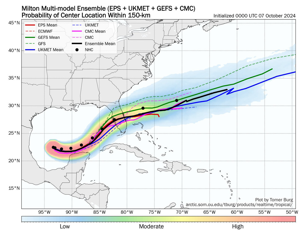
It actually looks like the 06Z Euro aims right for Tampa. Ugh.


Sent from my iPhone using Tapatalk


If this track were to verify it would be very similar to what we know of impact in 1859. 165 years ago. Long before this area was a major population center. It’s almost an unbelievable possibility.
2 likes   
Heather

User avatar
ScottNAtlanta
Category 5
Category 5
Posts: 2367
Joined: Sat May 25, 2013 3:11 pm
Location: Atlanta, GA

Re: ATL: MILTON - Models

#742 Postby ScottNAtlanta » Mon Oct 07, 2024 9:01 am

This has a really good discussion on the models. I found it very informative


Link: https://youtube.com/watch?v=sc10BUZQk5s
1 likes   
The posts in this forum are NOT official forecast and should not be used as such. They are just the opinion of the poster and may or may not be backed by sound meteorological data. They are NOT endorsed by any professional institution or storm2k.org. For official information, please refer to the NHC and NWS products.

User avatar
NDG
S2K Supporter
S2K Supporter
Posts: 15446
Joined: Sun Jul 09, 2006 10:14 pm
Location: Orlando, FL

Re: ATL: MILTON - Models

#743 Postby NDG » Mon Oct 07, 2024 9:08 am


SW FL still have bad memories of Ian and they don't trust the models yet.
0 likes   

FLLurker32
Tropical Storm
Tropical Storm
Posts: 245
Joined: Mon Aug 29, 2016 10:31 am

Re: ATL: MILTON - Models

#744 Postby FLLurker32 » Mon Oct 07, 2024 9:09 am


With Milton exceeding intensity timeframes in the past few hours I’m not as certain about the shift being real vs. a wobble based on models not being able to figure out the movement as it intensifies. NHC only shifted by 5 miles last time. It’ll be interesting to see how much faith they show in that south consensus nudge at 11am.
0 likes   
Heather

User avatar
NDG
S2K Supporter
S2K Supporter
Posts: 15446
Joined: Sun Jul 09, 2006 10:14 pm
Location: Orlando, FL

Re: ATL: MILTON - Models

#745 Postby NDG » Mon Oct 07, 2024 9:14 am

FLLurker32 wrote:


With Milton exceeding intensity timeframes in the past few hours I’m not as certain about the shift being real vs. a wobble based on models not being able to figure out the movement as it intensifies. NHC only shifted by 5 miles last time. It’ll be interesting to see how much faith they show in that south consensus nudge at 11am.


With the 06z Euro shifting north I doubt they will shift that much south as the consensus shows.
1 likes   

User avatar
SFLcane
S2K Supporter
S2K Supporter
Posts: 10163
Age: 47
Joined: Sat Jun 05, 2010 1:44 pm
Location: Lake Worth Florida

Re: ATL: MILTON - Models

#746 Postby SFLcane » Mon Oct 07, 2024 9:16 am

Image
6 likes   

FLLurker32
Tropical Storm
Tropical Storm
Posts: 245
Joined: Mon Aug 29, 2016 10:31 am

Re: ATL: MILTON - Models

#747 Postby FLLurker32 » Mon Oct 07, 2024 9:29 am

NDG wrote:
FLLurker32 wrote:


With Milton exceeding intensity timeframes in the past few hours I’m not as certain about the shift being real vs. a wobble based on models not being able to figure out the movement as it intensifies. NHC only shifted by 5 miles last time. It’ll be interesting to see how much faith they show in that south consensus nudge at 11am.


With the 06z Euro shifting north I doubt they will shift that much south as the consensus shows.


I agree. Notably, the models that have been closer to actual intensity (Still understated) are more northern going just over Tampa Bay or to the north of the Bay. The consensus is being skewed by models that are having a harder time on the intensity forecast.
1 likes   
Heather

User avatar
ScottNAtlanta
Category 5
Category 5
Posts: 2367
Joined: Sat May 25, 2013 3:11 pm
Location: Atlanta, GA

Re: ATL: MILTON - Models

#748 Postby ScottNAtlanta » Mon Oct 07, 2024 9:46 am

0 likes   
The posts in this forum are NOT official forecast and should not be used as such. They are just the opinion of the poster and may or may not be backed by sound meteorological data. They are NOT endorsed by any professional institution or storm2k.org. For official information, please refer to the NHC and NWS products.

MEANINGLESS_NUMBERS
Category 1
Category 1
Posts: 329
Joined: Mon Nov 02, 2020 1:43 pm

Re: ATL: MILTON - Models

#749 Postby MEANINGLESS_NUMBERS » Mon Oct 07, 2024 9:48 am

Image

Possible Bermuda landfall
2 likes   
Emily '87, Felix '95, Gert '99, Fabian '03, Humberto '19, Paulette '20, Teddy '20, Fiona '22, Lee '23, Ernesto '24

User avatar
Full8s
S2K Supporter
S2K Supporter
Posts: 51
Age: 44
Joined: Tue Aug 19, 2008 3:08 pm
Location: Hudson, Fl

Re: ATL: MILTON - Models

#750 Postby Full8s » Mon Oct 07, 2024 9:49 am

ScottNAtlanta wrote:This has a really good discussion on the models. I found it very informative
https://youtu.be/sc10BUZQk5s?si=qdWhTOp9QYRIdR3k


Thanks for posting.
Great/insightful video, albeit a bit concerning for those of us north of Tampa in Pasco County.
0 likes   
"All I know is that I don't know nothin'..."

User avatar
Blinhart
Category 5
Category 5
Posts: 2081
Age: 48
Joined: Thu Sep 08, 2011 3:13 pm
Location: Crowley, La.

Re: ATL: MILTON - Models

#751 Postby Blinhart » Mon Oct 07, 2024 9:50 am

MEANINGLESS_NUMBERS wrote:https://i.imgur.com/b5JrVZg.png

Possible Bermuda landfall


Could we have a Fujiwara of Leslie and Milton around Bermuda or East of Bermuda?
0 likes   
Personal Forecast Disclaimer:
The posts in this forum are NOT official forecast and should not be used as such. They are just the opinion of the poster and may or may not be backed by sound meteorological data. They are NOT endorsed by any professional institution or storm2k.org. For official information, please refer to the NHC and NWS products.

MEANINGLESS_NUMBERS
Category 1
Category 1
Posts: 329
Joined: Mon Nov 02, 2020 1:43 pm

Re: ATL: MILTON - Models

#752 Postby MEANINGLESS_NUMBERS » Mon Oct 07, 2024 9:51 am

HAFS-A with a hurricane-force hybrid frontal system messy thing raking hurricane force winds across Bermuda as well:

Image

HAFS-B slightly weaker but still brings TS winds to the island:

Image
0 likes   
Emily '87, Felix '95, Gert '99, Fabian '03, Humberto '19, Paulette '20, Teddy '20, Fiona '22, Lee '23, Ernesto '24

MEANINGLESS_NUMBERS
Category 1
Category 1
Posts: 329
Joined: Mon Nov 02, 2020 1:43 pm

Re: ATL: MILTON - Models

#753 Postby MEANINGLESS_NUMBERS » Mon Oct 07, 2024 9:53 am

HWRF doesn't reach Bermuda until Saturday. Weaker, slower, and less frontal. I have Sunday plans so this is not ideal.

Image
0 likes   
Emily '87, Felix '95, Gert '99, Fabian '03, Humberto '19, Paulette '20, Teddy '20, Fiona '22, Lee '23, Ernesto '24

User avatar
Steve
S2K Supporter
S2K Supporter
Posts: 9621
Joined: Sat Apr 05, 2003 11:41 pm
Location: Not a state-caster

Re: ATL: MILTON - Models

#754 Postby Steve » Mon Oct 07, 2024 9:55 am

NAM 12km is useless this run. It hits around 977mb but as it's going on a trajectory that would take it slightly north of Tampa it jumps right at landfall and goes in south of where you think it would. Only thing I can see that would cause that is the east Canadian trough 's western periphery is exiting the same time Milton is making landfall. Could happen, but I'm disregarding the tropical aspects of this run.

NAM 3km is a trip. It only goes out to 60 hours, but in the last data point it shows 3 lows pop out to the north. It's having a brain freeze or something. However IR simulation is showing degrading heading close to landfall from what it was as it starts coming into range which is encouraging (but it's the NAM)

"Lows"
https://www.tropicaltidbits.com/analysi ... 0712&fh=60

IR Sim
https://www.tropicaltidbits.com/analysi ... 0712&fh=60

FV3 Hi-res comes in at about 967 21z Wednesday +/- the bay/Pinellas
https://www.tropicaltidbits.com/analysi ... 0712&fh=57

ICON is running now. Unfortunately it's initialized with 981mb when it's like 50mb deeper. So track might be good but intensity probably not.
0 likes   

MEANINGLESS_NUMBERS
Category 1
Category 1
Posts: 329
Joined: Mon Nov 02, 2020 1:43 pm

Re: ATL: MILTON - Models

#755 Postby MEANINGLESS_NUMBERS » Mon Oct 07, 2024 9:55 am

Blinhart wrote:
MEANINGLESS_NUMBERS wrote:https://i.imgur.com/b5JrVZg.png

Possible Bermuda landfall


Could we have a Fujiwara of Leslie and Milton around Bermuda or East of Bermuda?


If it stays cyclonic. Most of the models show it merging with the frontal system (which has simultaneously sheared Leslie to death)
0 likes   
Emily '87, Felix '95, Gert '99, Fabian '03, Humberto '19, Paulette '20, Teddy '20, Fiona '22, Lee '23, Ernesto '24

MEANINGLESS_NUMBERS
Category 1
Category 1
Posts: 329
Joined: Mon Nov 02, 2020 1:43 pm

Re: ATL: MILTON - Models

#756 Postby MEANINGLESS_NUMBERS » Mon Oct 07, 2024 9:57 am

06Z GFS has Bermuda in the... eye? Some gap in the wind field anyway.

Image
0 likes   
Emily '87, Felix '95, Gert '99, Fabian '03, Humberto '19, Paulette '20, Teddy '20, Fiona '22, Lee '23, Ernesto '24

fsucory08
Tropical Low
Tropical Low
Posts: 39
Joined: Wed Aug 30, 2017 8:27 pm
Location: Port Saint Lucie, FL

Re: ATL: MILTON - Models

#757 Postby fsucory08 » Mon Oct 07, 2024 9:57 am

Icon slightly slower through 36 hours
Last edited by fsucory08 on Mon Oct 07, 2024 9:58 am, edited 1 time in total.
0 likes   

LandoWill
Tropical Storm
Tropical Storm
Posts: 154
Joined: Sun Sep 25, 2022 10:25 pm

Re: ATL: MILTON - Models

#758 Postby LandoWill » Mon Oct 07, 2024 9:58 am

ScottNAtlanta wrote:This has a really good discussion on the models. I found it very informative
https://youtu.be/sc10BUZQk5s?si=qdWhTOp9QYRIdR3k

The website they are using is http://arctic.som.ou.edu/tburg/products ... m=AL142024
0 likes   

User avatar
NDG
S2K Supporter
S2K Supporter
Posts: 15446
Joined: Sun Jul 09, 2006 10:14 pm
Location: Orlando, FL

Re: ATL: MILTON - Models

#759 Postby NDG » Mon Oct 07, 2024 10:01 am

Just a friendly reminder how off the TVCN consensus models was with Helene and also with Francine 60 hours before landfall and even at 24 hours before landfall.
That's the reason why I am putting more stock into the GFS, Euro and to some degree the ICON.

60 Hour forecast before landfall:
Image

24 Hour forecast before landfall:
Image
0 likes   

Stormlover70
Tropical Storm
Tropical Storm
Posts: 175
Age: 55
Joined: Fri Jun 21, 2024 5:31 am
Location: New port richey

Re: ATL: MILTON - Models

#760 Postby Stormlover70 » Mon Oct 07, 2024 10:02 am

MEANINGLESS_NUMBERS wrote:06Z GFS has Bermuda in the... eye? Some gap in the wind field anyway.

https://i.imgur.com/zZrBwqT.png
let's concentrate on florida right now.
3 likes   


Return to “2024”

Who is online

Users browsing this forum: No registered users and 14 guests