ATL: HELENE - Models

Moderator: S2k Moderators

Message
Author
FLLurker32
Tropical Storm
Tropical Storm
Posts: 245
Joined: Mon Aug 29, 2016 10:31 am

Re: ATL: HELENE - Models

#641 Postby FLLurker32 » Tue Sep 24, 2024 5:01 pm

StPeteMike wrote:
FLLurker32 wrote:
tolakram wrote:18Z running.

https://i.imgur.com/YVeO24n.png


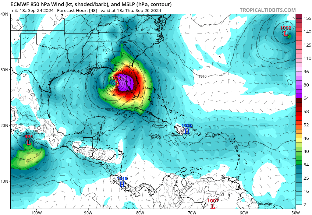
Initialized pretty close. This will be interesting.

Looks to get still close to Yucatán ( don’t see it but we will see) but also have a stronger right hand turn that puts Helene into Cedar Key.


Earlier today I noticed the 12z spaghetti models, while all were far to the west, showed the models that got closest to the Yucatán seemed to favor a more south/eastern impact on the big bend.
1 likes   
Heather

FLLurker32
Tropical Storm
Tropical Storm
Posts: 245
Joined: Mon Aug 29, 2016 10:31 am

Re: ATL: HELENE - Models

#642 Postby FLLurker32 » Tue Sep 24, 2024 5:05 pm

tolakram wrote:GFS still showing organizational issues. GFS is pretty good in this area, is it right?

https://i.imgur.com/p0BWFmL.png


NHC mentioned the possibility for some light sheer to hit it just before landfall. That may be what it’s showing with the structural issues there.
0 likes   
Heather

MJGarrison
Tropical Storm
Tropical Storm
Posts: 146
Joined: Wed Aug 30, 2017 7:26 pm

Re: ATL: HELENE - Models

#643 Postby MJGarrison » Tue Sep 24, 2024 5:19 pm

The 18Z GFS shows Helene exiting the Yucatán channel east of the 12Z, but landfall in Florida ends up just a bit west.


Sent from my iPad using Tapatalk
1 likes   

DunedinDave
Tropical Storm
Tropical Storm
Posts: 227
Joined: Fri Aug 25, 2023 10:31 am

Re: ATL: HELENE - Models

#644 Postby DunedinDave » Tue Sep 24, 2024 5:26 pm

The 18z GFS is ever so slightly EAST of its track when parallel with Tampa/St. Pete and approaching the west coast but actually now slightly WEST from the 12z when it comes to landfall.

I'm not sure what's causing this (maybe the experts can explain this better) but the GFS believes this thing is going turn more northerly, which obviously will spare places from Cedar Key to say Tarpon Springs.
0 likes   

User avatar
Travorum
Category 1
Category 1
Posts: 406
Joined: Tue Sep 05, 2023 9:36 am
Location: Dunedin, FL

Re: ATL: HELENE - Models

#645 Postby Travorum » Tue Sep 24, 2024 5:28 pm

DunedinDave wrote:The 18z GFS is ever so slightly EAST of its track when parallel with Tampa/St. Pete and approaching the west coast but actually now slightly WEST from the 12z when it comes to landfall.

I'm not sure what's causing this (maybe the experts can explain this better) but the GFS believes this thing is going turn more northerly, which obviously will spare places from Cedar Key to say Tarpon Springs.


Not an expert at all but looking at the 500mb level it seems like the trough is moving across the US faster but the high pressure to the southeast builds in stronger and slightly more west. The net result of that looks like Helene gets a combined push+pull to the north in the last 6 hours before landfall, therefore making landfall slightly west in the big bend.
2 likes   

DunedinDave
Tropical Storm
Tropical Storm
Posts: 227
Joined: Fri Aug 25, 2023 10:31 am

Re: ATL: HELENE - Models

#646 Postby DunedinDave » Tue Sep 24, 2024 5:41 pm

She's about to explode. I have a feeling we're going to wake up in the morning to a monster.
1 likes   

Keldeo1997
Category 2
Category 2
Posts: 637
Joined: Fri Oct 11, 2019 11:35 pm

Re: ATL: HELENE - Models

#647 Postby Keldeo1997 » Tue Sep 24, 2024 5:56 pm

20kt / 12h 14.1% 17.8% 16.0%
25kt / 24h 61.9% 73.3% 67.6%
30kt / 24h 41.8% 57.3% 49.5%
35kt / 24h 33.0% 56.8% 44.9%
40kt / 24h 8.0% 56.8% 32.4%
45kt / 36h 56.5% 80.4% 68.4%
55kt / 36h 0.0% 65.4% 32.7%
55kt / 48h 52.1% 67.1% 59.6%
70kt / 48h 45.1% 56.8% 50.9%
65kt / 72h 55.5% 16.9% 36.2%

Current SHIPS. The Eyebrow raiser here is what I have in bold. At around a coinflip to have 130kts at around landfall time.
4 likes   

User avatar
kevin
Category 5
Category 5
Posts: 2586
Age: 26
Joined: Wed Aug 28, 2019 4:35 am

Re: ATL: HELENE - Models

#648 Postby kevin » Tue Sep 24, 2024 6:00 pm

HAFS-B once again has way too much west motion and landfalls in Yucatan. It's current position of Helene (in between the 21z and 00z data points) is already off with about 0.4 degrees west bias. Despite this it's much more intense so far than 12z, 968 mb at +33 hr compared to 986 mb in the 12z run at that point in time.
1 likes   

BobHarlem
Category 5
Category 5
Posts: 2105
Joined: Thu Oct 20, 2005 6:11 pm

Re: ATL: HELENE - Models

#649 Postby BobHarlem » Tue Sep 24, 2024 6:18 pm

Low pressures: HMON dipping into the 930s again (So far). HAFS-B around 945 before landfall. HAFS-A gets to 933mb right before it reaches Steinhatchee. All seem stronger this run over the 12z.
1 likes   

User avatar
aspen
Category 5
Category 5
Posts: 8818
Joined: Sat Oct 12, 2019 7:10 pm
Location: Connecticut, USA

Re: ATL: HELENE - Models

#650 Postby aspen » Tue Sep 24, 2024 6:30 pm

kevin wrote:HAFS-B once again has way too much west motion and landfalls in Yucatan. It's current position of Helene (in between the 21z and 00z data points) is already off with about 0.4 degrees west bias. Despite this it's much more intense so far than 12z, 968 mb at +33 hr compared to 986 mb in the 12z run at that point in time.

HAFS-B also still seems to disrupt Helene a bit with the Yucatan. It’s never able to form a clean eyewall afterwards, just tons of competing bands.
0 likes   
Irene '11 Sandy '12 Hermine '16 5/15/2018 Derecho Fay '20 Isaias '20 Elsa '21 Henri '21 Ida '21

I am only a meteorology enthusiast who knows a decent amount about tropical cyclones. Look to the professional mets, the NHC, or your local weather office for the best information.

tolakram
Admin
Admin
Posts: 20009
Age: 62
Joined: Sun Aug 27, 2006 8:23 pm
Location: Florence, KY (name is Mark)

Re: ATL: HELENE - Models

#651 Postby tolakram » Tue Sep 24, 2024 6:30 pm

Not sure when I con runs, but here is the 18Z
Image
3 likes   
M a r k
- - - - -
Join us in chat: Storm2K Chatroom Invite. Android and IOS apps also available.

The posts in this forum are NOT official forecasts and should not be used as such. Posts are NOT endorsed by any professional institution or STORM2K.org. For official information and forecasts, please refer to NHC and NWS products.

User avatar
kevin
Category 5
Category 5
Posts: 2586
Age: 26
Joined: Wed Aug 28, 2019 4:35 am

Re: ATL: HELENE - Models

#652 Postby kevin » Tue Sep 24, 2024 6:45 pm

Just the blend this time since I don't have much time. Of course stronger than 12z with peak intensities of 941mb/98kt for HWRF, 936mb/121kt for HMON, 933mb/132kt for HAFS-A and 945mb/116kt for HAFS-B. Note that the HAFS models still show landfall on Yucatan.

Blend
PEAK: 939 mb @ 54 hrs | 107 kt @ 51 hrs
hr / pressure (mb) / wind (kt)
00 / 998 / 41
06 / 991 / 54
12 / 982 / 58
18 / 978 / 68 - C1
24 / 976 / 58
30 / 971 / 71
36 / 958 / 93 - C2
42 / 951 / 91
48 / 943 / 106 - C3
51 / 940 / 107
54 / 939 / 106 - landfall
57 / 944 / 76
3 likes   

869MB
S2K Supporter
S2K Supporter
Posts: 162
Joined: Thu Feb 14, 2019 9:49 pm
Location: Katy, TX

Re: ATL: HELENE - Models

#653 Postby 869MB » Tue Sep 24, 2024 6:45 pm

tolakram wrote:18Z running.

https://i.imgur.com/YVeO24n.png


Helene appears to be slightly ahead of schedule regarding what this 18Z GFS run depicts concerning intensity...

NOAA2 Mission #7 into HELENE
Type: Low-level Reconnaissance | Status: In Storm

As of 23:33 UTC Sep 24, 2024:
Aircraft Position: 19.62°N 85.17°W
Bearing: 270° at 226 kt
Altitude: 3090 gpm
Peak 10-second Wind: 16 kt at 217°
Extrapolated Sea-level Pressure: 991.0 mb
0 likes   

caneman
Category 5
Category 5
Posts: 1447
Joined: Fri Sep 05, 2014 5:44 am
Location: Clearwater Beach, Fl

Re: ATL: HELENE - Models

#654 Postby caneman » Tue Sep 24, 2024 6:50 pm

869MB wrote:
tolakram wrote:18Z running.

https://i.imgur.com/YVeO24n.png


Helene appears to be slightly ahead of schedule regarding what this 18Z GFS run depicts concerning intensity...

NOAA2 Mission #7 into HELENE
Type: Low-level Reconnaissance | Status: In Storm

As of 23:33 UTC Sep 24, 2024:
Aircraft Position: 19.62°N 85.17°W
Bearing: 270° at 226 kt
Altitude: 3090 gpm
Peak 10-second Wind: 16 kt at 217°
Extrapolated Sea-level Pressure: 991.0 mb


If that heading stays true, the nhc had it getting to 86. Would be a miss of 60 miles which would lend credence to icons cedar key hit. Something to watch. If that were to happen, storm surge values would go way up for the Tampa Bay area
2 likes   

User avatar
gatorcane
S2K Supporter
S2K Supporter
Posts: 23691
Age: 47
Joined: Sun Mar 13, 2005 3:54 pm
Location: Boca Raton, FL

Re: ATL: HELENE - Models

#655 Postby gatorcane » Tue Sep 24, 2024 7:09 pm

Looks like the 18Z ECMWF shifted slightly east of the 12Z ECMWF on its closest approach to the Tampa area. Also has a stronger cyclone, with the highest 850MB winds on the east side:

Image
Last edited by gatorcane on Tue Sep 24, 2024 7:11 pm, edited 2 times in total.
2 likes   

tolakram
Admin
Admin
Posts: 20009
Age: 62
Joined: Sun Aug 27, 2006 8:23 pm
Location: Florence, KY (name is Mark)

Re: ATL: HELENE - Models

#656 Postby tolakram » Tue Sep 24, 2024 7:10 pm

Hurricane model animations

Image

Image

Image

Image
2 likes   
M a r k
- - - - -
Join us in chat: Storm2K Chatroom Invite. Android and IOS apps also available.

The posts in this forum are NOT official forecasts and should not be used as such. Posts are NOT endorsed by any professional institution or STORM2K.org. For official information and forecasts, please refer to NHC and NWS products.

User avatar
Bocadude85
Category 5
Category 5
Posts: 2991
Age: 38
Joined: Mon Apr 18, 2005 2:20 pm
Location: Honolulu,Hi

Re: ATL: HELENE - Models

#657 Postby Bocadude85 » Tue Sep 24, 2024 7:45 pm

gatorcane wrote:Looks like the 18Z ECMWF shifted slightly east of the 12Z ECMWF on its closest approach to the Tampa area. Also has a stronger cyclone, with the highest 850MB winds on the east side:

https://i.postimg.cc/WbDNq0fJ/ec-fast-mslp-uv850-watl-3.png


It did shift east, was just looking at it. Hopefully not the start of a trend. The 0z cycle will be interesting.
2 likes   

User avatar
chaser1
S2K Supporter
S2K Supporter
Posts: 5464
Age: 64
Joined: Sat Oct 15, 2005 5:59 pm
Location: Longwood, Fl

Re: ATL: HELENE - Models

#658 Postby chaser1 » Tue Sep 24, 2024 7:46 pm

Has anyone calculated how many miles Helene is projected to be from Tampa Bay based on the EURO (or any other model run)?

The storm is certainly looking a good deal more healthy this evening. I'm still not hearing or seeing anything that would lead me to consider any increased risk for a forecast track that would bring the core any closer to the Tampa to Clearwater area thus far. Granted, things could change.
1 likes   
Andy D

(For official information, please refer to the NHC and NWS products.)

BIFF_THE_UNRULY
Tropical Storm
Tropical Storm
Posts: 143
Joined: Fri Jun 28, 2024 2:12 pm

Re: ATL: HELENE - Models

#659 Postby BIFF_THE_UNRULY » Tue Sep 24, 2024 7:57 pm

chaser1 wrote:Has anyone calculated how many miles Helene is projected to be from Tampa Bay based on the EURO (or any other model run)?

The storm is certainly looking a good deal more healthy this evening. I'm still not hearing or seeing anything that would lead me to consider any increased risk for a forecast track that would bring the core any closer to the Tampa to Clearwater area thus far. Granted, things could change.


Looks to be about 70 miles give or take 10
2 likes   

User avatar
gatorcane
S2K Supporter
S2K Supporter
Posts: 23691
Age: 47
Joined: Sun Mar 13, 2005 3:54 pm
Location: Boca Raton, FL

Re: ATL: HELENE - Models

#660 Postby gatorcane » Tue Sep 24, 2024 7:58 pm

The GFS track has an intensifying hurricane headed NE for the west coast of Florida / Tampa area but turns NNE just in time, certainly this kind of track will be a bit of a nailbiter the day of the event:

Image
3 likes   


Return to “2024”

Who is online

Users browsing this forum: No registered users and 1 guest