https://wxman57.com/images/12ZConsensus.JPG

https://wxman57.com/images/SLOSHCat3.JPG

Moderator: S2k Moderators


psyclone wrote:I'm thinking a series of steady southward adjustments starting at 11 eventually aims this around Venice or Englewood...such a scenario could empty tampa bay and overflow Charlotte Harbor.. Plus everyone knows...when a cane is coming to tampa...get out of punta Gorda! I mean we will see how things unfold but that scenario just seems like a reasonable one


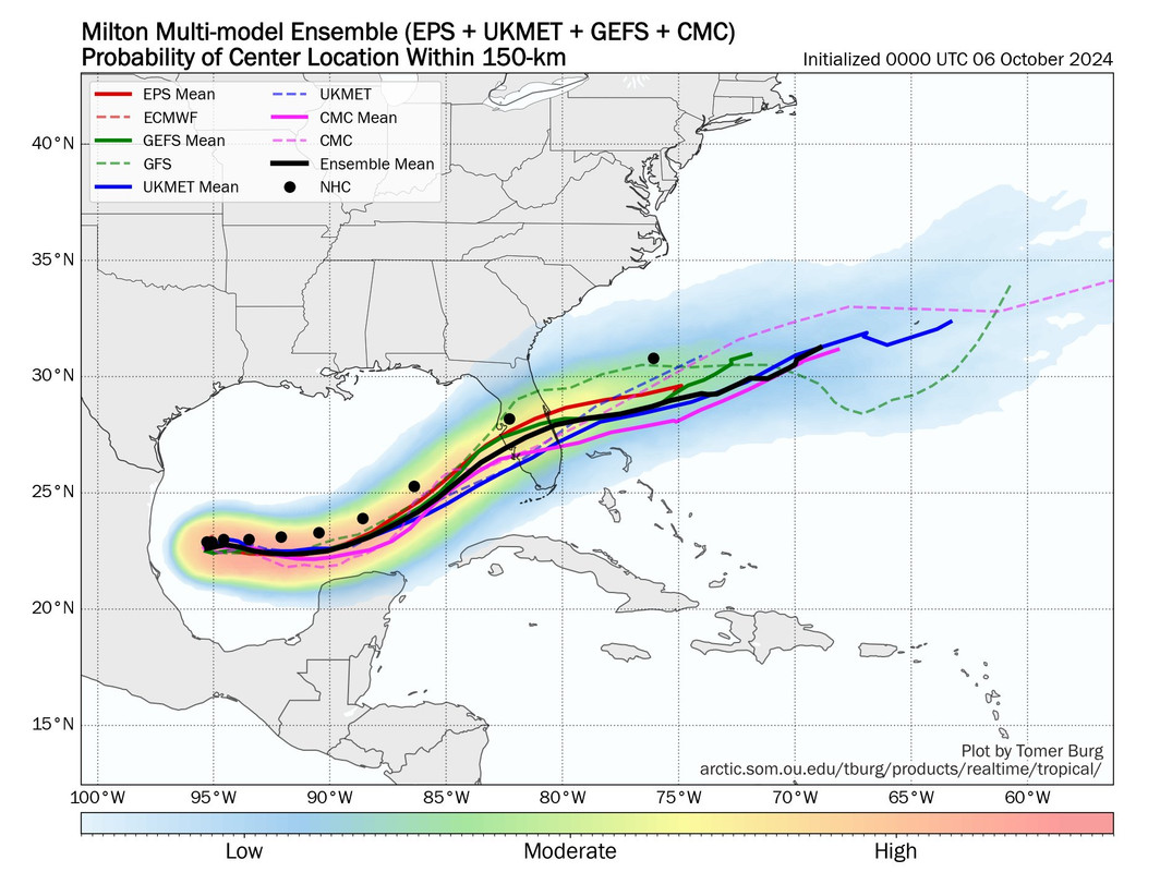
wxman57 wrote:Storms moving up against a jet stream always track right of the forecast (Francine, Helene, Charley, etc). Consensus (green) and corrected consensus (gray) are now well south of NHC's track (maroon). Look for a gradual NHC track shift south of TPA. They may not do it this morning, but it's coming. Meanwhile, for those of you in Tampa, the SLOSH map below indicates what kind of surge you would see with NHC's current track. Over 18ft into NE Tampa Bay. You definitely want it going in to the south.
https://wxman57.com/images/12ZConsensus.JPG
https://wxman57.com/images/12ZConsensus.JPG
https://wxman57.com/images/SLOSHCat3.JPG
https://wxman57.com/images/SLOSHCat3.JPG
GCANE wrote:Big-ass hot tower firing off


SFLcane wrote:wxman57 wrote:Storms moving up against a jet stream always track right of the forecast (Francine, Helene, Charley, etc). Consensus (green) and corrected consensus (gray) are now well south of NHC's track (maroon). Look for a gradual NHC track shift south of TPA. They may not do it this morning, but it's coming. Meanwhile, for those of you in Tampa, the SLOSH map below indicates what kind of surge you would see with NHC's current track. Over 18ft into NE Tampa Bay. You definitely want it going in to the south.
https://wxman57.com/images/12ZConsensus.JPG
https://wxman57.com/images/12ZConsensus.JPG
https://wxman57.com/images/SLOSHCat3.JPG
https://wxman57.com/images/SLOSHCat3.JPG
NHC is north of almost all the ensembles.
https://i.postimg.cc/3xMVMWn3/IMG-9571.jpg
jasons2k wrote:This is a really tough forecast, and it involves the Bay Area with a possible major.
What a nightmare for emergency preparations folks, and the residents flooded by Helene.
The barrier islands are still a mess. Everyone’s trash is on the curbs right now turning to mold and getting rained on. It’s a horrible situation about to get worse.
Jr0d wrote:jasons2k wrote:This is a really tough forecast, and it involves the Bay Area with a possible major.
What a nightmare for emergency preparations folks, and the residents flooded by Helene.
The barrier islands are still a mess. Everyone’s trash is on the curbs right now turning to mold and getting rained on. It’s a horrible situation about to get worse.
I remember being in Cocoa Beach in 2004, after Frances did some damage there and almost everyones front yard was full of trash and debris when Jeanne became a threat.
Brevard county did a great job of having crews almost 24/7 collecting trash and debris before Jeanne impacted us.
Hopefully they are doing that as we speak...but obviously the damage from Helene is much worse and I dont see how they will be able to fully pickup all the debris before Helene.
I think we all hope the storm stays south, despite seeing in a much bigger impact for those of us living in South and southwest Florida.
jlauderdal wrote:GCANE wrote:Big-ass hot tower firing off
Michael Fischer just posted about that and he doesnt get impressed easily.
Fun&GamesUntil wrote:When I click on any of these links it takes me to this page:
This Connection Is Not Private
This website may be impersonating “wxman57.com” to steal your personal or financial information. You should go back to the previous page.
Has this happened to anyone else? I really want to see wxman’s images.
Users browsing this forum: No registered users and 47 guests


