Hurrilurker wrote:This has to be a hurricane at the next NHC update doesn't it? It might already be there.
recon finding nothing to support this
Moderator: S2k Moderators

Hurrilurker wrote:This has to be a hurricane at the next NHC update doesn't it? It might already be there.


Steve wrote:I think it’s stunting it for now. I love Dylan and 57 so it’s okay for them to see it different. I think it shows up good on Longwave IR. But tomorrow is intensification day so I think this is no harm no foul as far as part of the organizing process.
psyclone wrote:Dry air is clearly keeping things in check now...but should that abate at some point..the structure is there to bulk up quickly.
psyclone wrote:Dry air is clearly keeping things in check now...but should that abate at some point..the structure is there to bulk up quickly.


Hurrilurker wrote:This has to be a hurricane at the next NHC update doesn't it? It might already be there.


wxman57 wrote:Hurrilurker wrote:This has to be a hurricane at the next NHC update doesn't it? It might already be there.
Recon has not found any wind stronger than 45 kts. It's weaker than this afternoon.

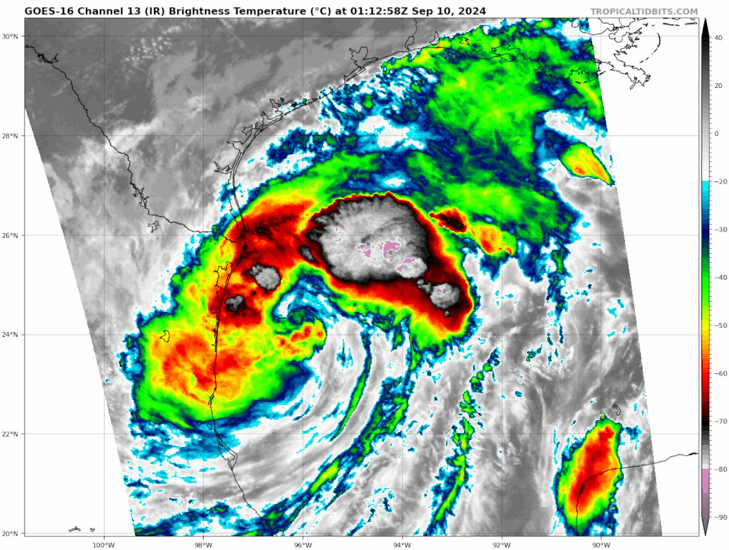
wxman57 wrote:Francine is enjoying an evening meal of dry air. It's wrapped almost all around the core. That'll slow any strengthening. Looks like an eye was starting to form this afternoon, not now.
https://wxman57.com/images/DryAir.JPG
https://wxman57.com/images/DryAir.JPG
Hurrilurker wrote:This has to be a hurricane at the next NHC update doesn't it? It might already be there.


wxman57 wrote:Hurrilurker wrote:This has to be a hurricane at the next NHC update doesn't it? It might already be there.
Recon has not found any wind stronger than 45 kts. It's weaker than this afternoon. Correction, second plane found about 50 kts in convection along the MX coast.


wxman57 wrote:cajungal wrote:MONTEGUT_LA wrote:
On my way now to pick up more supplies and then we going to head to Thibodaux to my son's house. We had minor flooding for ida, but she hit more to the east of us. I never trust the leeves lol
I am in Thibodaux. Just can’t believe here we go again
The track may well end up right over your area or just west. Prepare for extended power outages starting Wed PM.
Teban54 wrote:Some new convective bursts around the eyewall, especially to the SW. As a result, the eye is easily visible on IR again.
NOAA plane just found 57 kt FL in the NE quad.
https://i.postimg.cc/t4qhHPDp/goes16-ir-meso1.gif
Current Intensity Analysis
UW - CIMSS
ADVANCED DVORAK TECHNIQUE
ADT-Version 9.1
Tropical Cyclone Intensity Algorithm
----- Current Analysis -----
Date : 10 SEP 2024 Time : 014020 UTC
Lat : 24:25:36 N Lon : 96:16:11 W
CI# /Pressure/ Vmax
3.4 / 988.5mb/ 53.0kt
Final T# Adj T# Raw T#
2.6 3.1 3.2
Center Temp : -2.7C Cloud Region Temp : -44.9C
Scene Type : CURVED BAND with 0.83 ARC in MD GRAY
Subtropical Adjustment : OFF
Extratropical Adjustment : OFF
Users browsing this forum: No registered users and 35 guests


