ATL: BERYL - Post-Tropical - Discussion

Moderator: S2k Moderators

Message
Author
User avatar
LadyBug72
Tropical Storm
Tropical Storm
Posts: 118
Joined: Mon Jun 01, 2020 3:39 pm
Location: about 20 miles from Galveston, Tx

Re: ATL: BERYL - Tropical Storm - Discussion

#3721 Postby LadyBug72 » Sun Jul 07, 2024 2:08 pm

galvbay wrote:Lurker from way back (joined 2002). Just checking in from Anahuac/Oak Island. Squall line came through around 11 this morning maybe 3/4” with 30 mph gust. Looking for 4-50 mph gust next 24 hrs. Stay safe S2K members.
Anyone know what happened to Ticka?


Sending you a private message.
1 likes   
Formerly known as the user: Nikki

Alicia 83, Allison 01, Rita 05, Ike 08, Harvey 17, Nicholas 21, Coastal Texas Derecho 24, Beryl 24

capNstorms
Tropical Storm
Tropical Storm
Posts: 128
Age: 32
Joined: Mon Jun 14, 2021 12:48 pm
Location: Beaumont, TX

Re: ATL: BERYL - Tropical Storm - Discussion

#3722 Postby capNstorms » Sun Jul 07, 2024 2:11 pm

the GFS, CMC, ICON models still have Beryl in the GOM in the 12z models at 18 hours, I think some of the other 12z models are showing it slowing down giving it more time to develop over the GOM, its wobble time 8-)
3 likes   

capNstorms
Tropical Storm
Tropical Storm
Posts: 128
Age: 32
Joined: Mon Jun 14, 2021 12:48 pm
Location: Beaumont, TX

Re: ATL: BERYL - Tropical Storm - Discussion

#3723 Postby capNstorms » Sun Jul 07, 2024 2:12 pm

that core is wrapping up son!
0 likes   

User avatar
weeniepatrol
Category 5
Category 5
Posts: 1276
Joined: Sat Aug 22, 2020 5:30 pm
Location: WA State

Re: ATL: BERYL - Tropical Storm - Discussion

#3724 Postby weeniepatrol » Sun Jul 07, 2024 2:13 pm

Poleward outflow is tapping into the jet stream, as forecast

Image

Such intense mass evacuation of air from Beryl does support the notion of robust pressure falls, like HWRF shows. Assuming nothing disrupts the system.
8 likes   

User avatar
CypressMike
Tropical Low
Tropical Low
Posts: 41
Joined: Mon Aug 20, 2007 2:28 pm
Location: Cypress, TX
Contact:

Re: ATL: BERYL - Tropical Storm - Discussion

#3725 Postby CypressMike » Sun Jul 07, 2024 2:15 pm

RachelAnna wrote:
capNstorms wrote:Organizing and forming that eye, then faster rate of deepening will follow once it's into that sweet spot, and a strengthening hurricane on landfall, IMO... those winds will intensify and burst to the surface. It's starting to make the north jog to my naked eye on satellite.
Matagorda Bay to Galveston all the way to Sabine pass need to be on High alert for the storm surge, 6'+ 8-10' possibly with the high tide coming in and high wind bursts from a strengthening hurricane...

Houston, SETX, and EAST Texas counties need to prepare for possibly a foot of rainfall over the next 36hrs if this thing doesn't start moving faster than the models had initialized... FV3, HRRR, WRF-ARW, all showing copious amounts of rainfall. If you have any last minute preparations to make, now is the time to make them.


Had the first feeder move in NW of Houston a bit ago. Some pretty impressive wind gusts and rainfall. All the people laughing about the storm yesterday probably had their eyes opened a bit…


I recorded a 40 mph gust in Cypress (Bridgeland) when the leading edge of that feeder band came through.
4 likes   
Weather for the Bridgeland community of Cypress, TX
http://bridgelandweather.com/

capNstorms
Tropical Storm
Tropical Storm
Posts: 128
Age: 32
Joined: Mon Jun 14, 2021 12:48 pm
Location: Beaumont, TX

Re: ATL: BERYL - Tropical Storm - Discussion

#3726 Postby capNstorms » Sun Jul 07, 2024 2:17 pm

capNstorms wrote:that core is wrapping up son!

"Beryl will strengthen to a hurricane near 27.1N 95.7W this evening" per NWS Marine Forecast
0 likes   

StormPyrate
Category 1
Category 1
Posts: 279
Joined: Sun May 27, 2018 8:41 pm
Location: Clearwater, FL

Re: ATL: BERYL - Tropical Storm - Discussion

#3727 Postby StormPyrate » Sun Jul 07, 2024 2:17 pm

any actual evidence its coming together?
seems to be bad on Sat imagery, not really improving
0 likes   
St Petersburg Florida

Craters
Category 1
Category 1
Posts: 421
Joined: Sat Aug 24, 2013 2:34 pm
Location: Alvin, TX (south of Houston)

Re: ATL: BERYL - Tropical Storm - Discussion

#3728 Postby Craters » Sun Jul 07, 2024 2:20 pm

Steve wrote:
Craters wrote:
Wampadawg wrote:Hurricane Warning just blasted across my phone for Brazoria county!

Yup -- here, too, also in Brazoria County.


Y’all were my call yesterday. Hair east of the bay maybe 982 (could drop lower) and cat 1 strengthening coming in. I was looking at EPS and GPS means and nudged it east due to the icon. Hope to be close on those calls but more hope all you down there come out okay.

Thanks, Steve. Yeah, we're hoping like crazy that RI won't go bonkers. I mean, if it gets to a CAT 1 storm between now and landfall, I guess RI would be a given, by definition, but any more than that would be evil.
3 likes   
Nothing that I post here should ever be treated as a forecast or anything resembling one. Please check with your local NWS office or the NHC for forecasts, watches, and warnings.

IcyTundra
Category 5
Category 5
Posts: 1205
Joined: Mon Jun 07, 2021 9:32 pm
Location: Dickinson, Texas

Re: ATL: BERYL - Tropical Storm - Discussion

#3729 Postby IcyTundra » Sun Jul 07, 2024 2:22 pm

StormPyrate wrote:any actual evidence its coming together?
seems to be bad on Sat imagery, not really improving


Radar presentation is improving. Pressure dropped from what recon found this morning.
3 likes   

User avatar
Blown Away
S2K Supporter
S2K Supporter
Posts: 10145
Joined: Wed May 26, 2004 6:17 am

Re: ATL: BERYL - Tropical Storm - Discussion

#3730 Postby Blown Away » Sun Jul 07, 2024 2:23 pm

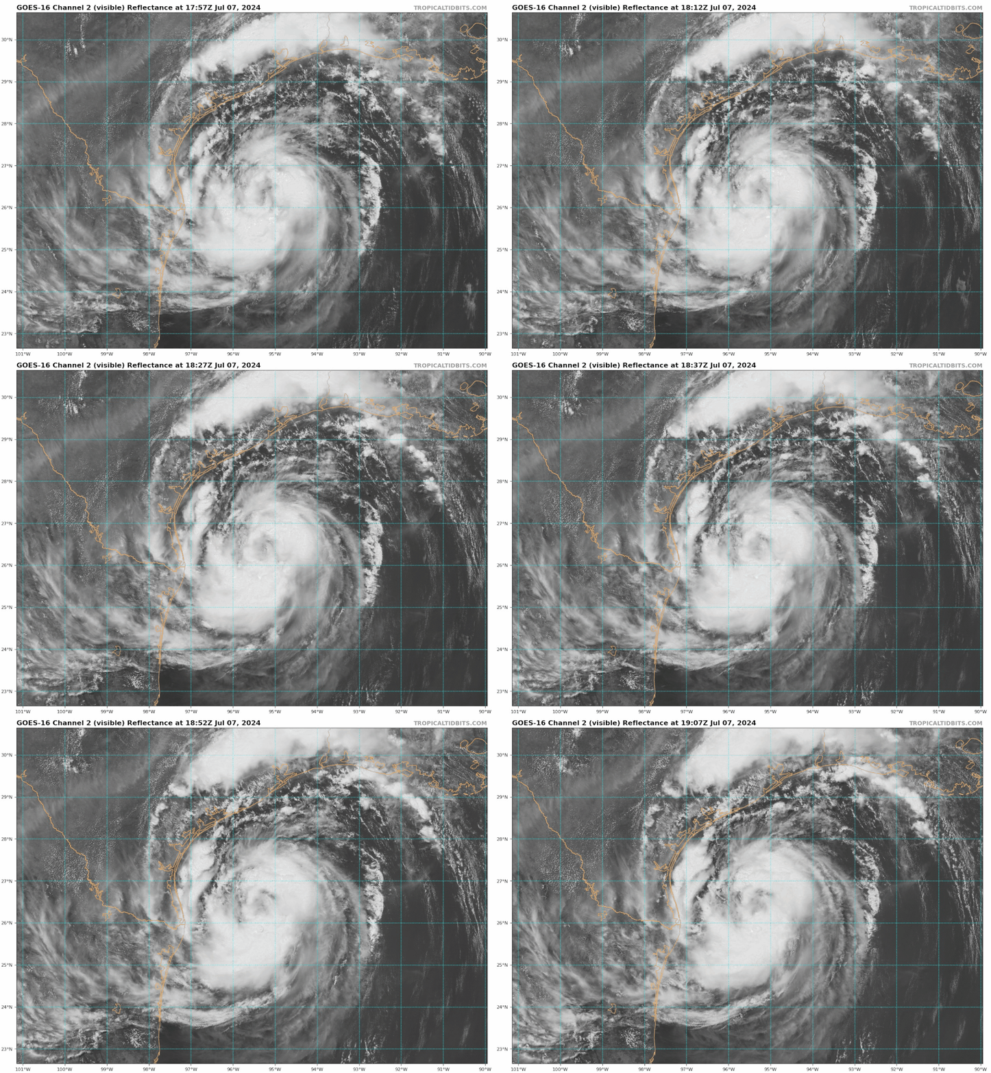
Image

Low level structure looks really good, being able to see the low level clouds rotating not a great sign of a strengthening system IMO…
3 likes   
Hurricane Eye Experience: David 79, Irene 99, Frances 04, Jeanne 04, Wilma 05... EYE COMING MY WAY IN 2024…
Hurricane Brush Experience: Andrew 92, Erin 95, Floyd 99, Matthew 16, Irma 17, Ian 22, Nicole 22…

capNstorms
Tropical Storm
Tropical Storm
Posts: 128
Age: 32
Joined: Mon Jun 14, 2021 12:48 pm
Location: Beaumont, TX

Re: ATL: BERYL - Tropical Storm - Discussion

#3731 Postby capNstorms » Sun Jul 07, 2024 2:25 pm

hot towers popping off in the SE quad, core wrapping around, favorable environment for RI
https://www.tropicaltidbits.com/sat/satlooper.php?region=02L&product=vis

where's the dry air at?
Image

very favorable to develope...
Image

these rainfall totals are looking juicy
Image
1 likes   

capNstorms
Tropical Storm
Tropical Storm
Posts: 128
Age: 32
Joined: Mon Jun 14, 2021 12:48 pm
Location: Beaumont, TX

Re: ATL: BERYL - Tropical Storm - Discussion

#3732 Postby capNstorms » Sun Jul 07, 2024 2:28 pm

Image
1 likes   

User avatar
ronjon
Category 5
Category 5
Posts: 4822
Joined: Fri Aug 19, 2005 5:17 pm
Location: Hernando Beach, FL

Re: ATL: BERYL - Tropical Storm - Discussion

#3733 Postby ronjon » Sun Jul 07, 2024 2:30 pm

Blown Away wrote:[url]https://i.postimg.cc/xCjnYnPr/goes16-vis-02-L-202407071757-2.gif [/url]

Low level structure looks really good, being able to see the low level clouds rotating not a great sign of a strengthening system IMO…


Agree BA. Dry air still mixing into the system preventing that heavy dense CDO needed for significant pressure drops. Has a way to go still to make a hurricane.
1 likes   

IsabelaWeather
Category 1
Category 1
Posts: 287
Age: 35
Joined: Tue Jul 07, 2020 7:29 am
Location: Isabela, Puerto Rico

Re: ATL: BERYL - Hurricane - Discussion

#3734 Postby IsabelaWeather » Sun Jul 07, 2024 2:31 pm

Nederlander wrote:
IsabelaWeather wrote:
I don't think we need this crap on the forums. This shouldnt be a place to criticize professional mets who have to balance public opinion and public awareness. 4 days ago it looked like the storm was going to tampico, there is no reason to start talking about a galveston landfall. That unnecessarily frightens people. You guys are making "forecasts" with hindsight 2020 as if it were obvious where the storm was going to go.

Many people here also have no risk whatsoever by just throwing out calls. Sure sometimes you get it right when you just check darts randomly at the dartboard.


Some criticism is fair and warranted. There’s way too much model hugging and not enough old fashioned meteorology. The problem is that there were signs fairly early on that some models were picking up on (namely the ICON, Navy, and JWA) that the ridge could break down, but the typical favorite models weren’t giving into that.

The other problem is when Mets (and the general public) use definitive statements instead of probabilities.

There’s no way to sugarcoat this one. This was a rather big miss for models and also some mets who were convinced this was a Mexico issue.


That isn't true. There were plenty of meteorological reasons the storm could have went into CA or Mexico. The longwave trough could easily have moved slower, the big thing here is beryl was stronger and more resilient to the shear. Turned the TUTT into a retrograding upperlevel low. Had it been disrupted then it would have went SW to W into CA or Mex. Take the exact same scenario you could easily have had a disrupted storm that did not behave like Beryl. Sometimes there are randomness you cant forecast or maybe there is something we still don't fully understand.

You are just using the benefit of hindsight to make it sound so obvious.

I also don't think the models busted that badly, there were many ensemble members that took the track it ended up taking, the NHC track was pretty darn good from the outset.
3 likes   

User avatar
GCANE
S2K Supporter
S2K Supporter
Posts: 11497
Joined: Mon Oct 22, 2007 8:03 am

Re: ATL: BERYL - Tropical Storm - Discussion

#3735 Postby GCANE » Sun Jul 07, 2024 2:33 pm

Shear holding steady at 9 knts
0 likes   

User avatar
GCANE
S2K Supporter
S2K Supporter
Posts: 11497
Joined: Mon Oct 22, 2007 8:03 am

Re: ATL: BERYL - Tropical Storm - Discussion

#3736 Postby GCANE » Sun Jul 07, 2024 2:35 pm

CAPE 9500!
Never seen it this high before
4 likes   

User avatar
RachelAnna
Tropical Storm
Tropical Storm
Posts: 106
Joined: Mon Jun 28, 2010 10:38 pm
Location: Cypress, Texas

Re: ATL: BERYL - Tropical Storm - Discussion

#3737 Postby RachelAnna » Sun Jul 07, 2024 2:37 pm

CypressMike wrote:
RachelAnna wrote:
capNstorms wrote:Organizing and forming that eye, then faster rate of deepening will follow once it's into that sweet spot, and a strengthening hurricane on landfall, IMO... those winds will intensify and burst to the surface. It's starting to make the north jog to my naked eye on satellite.
Matagorda Bay to Galveston all the way to Sabine pass need to be on High alert for the storm surge, 6'+ 8-10' possibly with the high tide coming in and high wind bursts from a strengthening hurricane...

Houston, SETX, and EAST Texas counties need to prepare for possibly a foot of rainfall over the next 36hrs if this thing doesn't start moving faster than the models had initialized... FV3, HRRR, WRF-ARW, all showing copious amounts of rainfall. If you have any last minute preparations to make, now is the time to make them.


Had the first feeder move in NW of Houston a bit ago. Some pretty impressive wind gusts and rainfall. All the people laughing about the storm yesterday probably had their eyes opened a bit…


I recorded a 40 mph gust in Cypress (Bridgeland) when the leading edge of that feeder band came through.


Same here! I’m off 290 at Telge and Spring Cypress. Got about 3/4 of an inch of rain, as well.
2 likes   

User avatar
canebeard
Tropical Depression
Tropical Depression
Posts: 98
Joined: Sun Jul 05, 2009 4:06 pm
Contact:

Re: ATL: BERYL - Tropical Storm - Discussion

#3738 Postby canebeard » Sun Jul 07, 2024 2:37 pm

Blown Away wrote:
canebeard wrote:https://i.imgur.com/x55tBV3.png

1979, Cat 5 Hurricane David (926 mb) hit Hispanola, and came off the island and headed for Florida. Organization looked excellent, outflow excellent, and hurricane warnings went up for S. and central Florida, and steady intensification forecast repeatedly until landfall. Two+ days later the highest winds recorded on land were at Ft. Pierce, were only 70 mph sustained. Point, looked great, Labor Day weekend, hot ocean, but not much re-intensification occurred to everyone's surprise,.


David gusted to mid 90’s from Jupiter to Ft. Pierce. There was heavy vegetation and roof damage.


Jim Leonard and myself were in the area, me in Jupiter, Jim in Ft. Pierce. The 95 mph GUST was recorded at the Coast Guard station, very exposed on the south side of the inlet to the northeast wind, which is on the short causeway from the mainland to the jetty into the ocean. Hence, winds in Ft Pierce itself on the mainland were less, for sure. The damage was typical for a high end tropical storm, with a few hurricane gusts; in a place where trees hadn't been wind trimmed in many years. This quote is from the great Wikipedia: "Some clapboard-style homes in the county suffered major damage, especially in Gifford and other low income communities" IE. shacks and other old poorly built domiciles.
Last edited by canebeard on Sun Jul 07, 2024 2:53 pm, edited 3 times in total.
0 likes   
List of 79 tropical cyclones intercepted by Richard Horodner:
http://www.canebeard.com/page/page/572246.htm
former storm2k screenname Beoumont 2009+

User avatar
Kazmit
Category 5
Category 5
Posts: 2124
Age: 22
Joined: Mon Jul 25, 2016 8:49 am
Location: Williamsburg, VA / Bermuda

Re: ATL: BERYL - Tropical Storm - Discussion

#3739 Postby Kazmit » Sun Jul 07, 2024 2:38 pm

Looking a lot like Nicole 2022 right now. A mess of a hurricane.

Image
3 likes   
Igor 2010, Sandy 2012, Fay 2014, Gonzalo 2014, Joaquin 2015, Nicole 2016, Humberto 2019

I am only a tropical weather enthusiast. My predictions are not official and may or may not be backed by sound meteorological data. For official information, please refer to the NHC and NWS products.

User avatar
ScottNAtlanta
Category 5
Category 5
Posts: 2367
Joined: Sat May 25, 2013 3:11 pm
Location: Atlanta, GA

Re: ATL: BERYL - Tropical Storm - Discussion

#3740 Postby ScottNAtlanta » Sun Jul 07, 2024 2:38 pm

It looks like the dry air is finally mixing out, and outflow is now pretty good in all quadrants so it just needs to fire some convection near the center for this to go. Look for hot towers near the center, and when they start rotating, you know it is off to the races.
Last edited by ScottNAtlanta on Sun Jul 07, 2024 4:21 pm, edited 1 time in total.
4 likes   
The posts in this forum are NOT official forecast and should not be used as such. They are just the opinion of the poster and may or may not be backed by sound meteorological data. They are NOT endorsed by any professional institution or storm2k.org. For official information, please refer to the NHC and NWS products.


Return to “2024”

Who is online

Users browsing this forum: Google Adsense [Bot], StormWeather and 14 guests