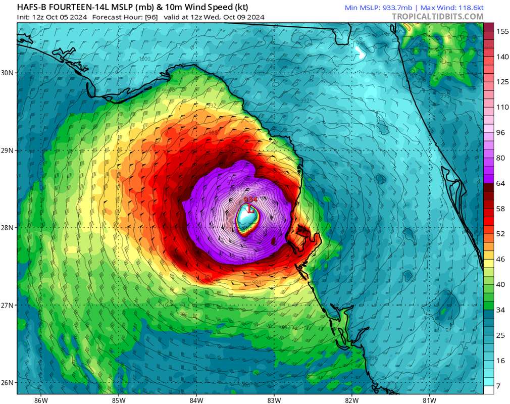
ATL: MILTON - Models

Moderator: S2k Moderators

Message
Author
User avatar
aspen
Category 5
Category 5
Posts: 8818
Joined: Sat Oct 12, 2019 7:10 pm
Location: Connecticut, USA

Re: ATL: MILTON - Models

#161 Postby aspen » Sat Oct 05, 2024 12:50 pm

ConvergenceZone wrote:
aspen wrote:HAFS-B peaks at 145 kt/919 mbar on Tuesday night despite increasing shear.

HWRF begins RI much sooner than the HAFS models. Takes about a day to organize, then goes bananas north of the Yucatan. It’s also the furthest south of the three models, which keeps it away from the shear and gives it a little more time.


Hurricanes this season haven't really cared much about shear. I think it was Francine that suppose to have weakened quite a bit due to shear. The shear was there, but the storm didn't weaken. I just no longer trust shear maps. The storm is going to do what it's going to do.

Francine was still greatly impacted, though. Didn’t surpass low-end Cat 2 intensity despite the record SSTs of the gulf. All models are showing shear having an impact so it cannot be disregarded.
2 likes   
Irene '11 Sandy '12 Hermine '16 5/15/2018 Derecho Fay '20 Isaias '20 Elsa '21 Henri '21 Ida '21

I am only a meteorology enthusiast who knows a decent amount about tropical cyclones. Look to the professional mets, the NHC, or your local weather office for the best information.

User avatar
gatorcane
S2K Supporter
S2K Supporter
Posts: 23691
Age: 47
Joined: Sun Mar 13, 2005 3:54 pm
Location: Boca Raton, FL

Re: ATL: MILTON - Models

#162 Postby gatorcane » Sat Oct 05, 2024 12:52 pm

Looks like the Hurricane models all shifted north a bit, which isn't good news for the Tampa area with those models showing landfalls north of Tampa which would put strong SW winds into the Tampa area.

For example, HAFS-B:
Image
Last edited by gatorcane on Sat Oct 05, 2024 12:54 pm, edited 2 times in total.
3 likes   

User avatar
kevin
Category 5
Category 5
Posts: 2586
Age: 26
Joined: Wed Aug 28, 2019 4:35 am

Re: ATL: MILTON - Models

#163 Postby kevin » Sat Oct 05, 2024 12:52 pm

Here we go again... Blend will follow soon when all models are finished running.

Image
3 likes   

User avatar
Steve
S2K Supporter
S2K Supporter
Posts: 9620
Joined: Sat Apr 05, 2003 11:41 pm
Location: Not a state-caster

Re: ATL: MILTON - Models

#164 Postby Steve » Sat Oct 05, 2024 12:53 pm

Click your favorite MJO model. All we needed for development all season was a dip into 8-1-2-3. It was clockwork. The bulk of the peak was spent in 5-6-7 and the circle which was highly fortuitous despite the repeated Gulf hits. As it is today MJO is barely out of the circle in 2/3 but it will
Skim the edge of the circle near 3 for the next 4 days. And what do we get? A landfalling hurricane. Some years MJO matters more than others. 2024 goes down as a year where it was highly predictive.

https://www.cpc.ncep.noaa.gov/products/ ... r_wh.shtml
4 likes   

Pelicane
Tropical Storm
Tropical Storm
Posts: 100
Joined: Tue Sep 13, 2022 1:52 pm
Location: Lafayette, Louisiana

Re: ATL: MILTON - Models

#165 Postby Pelicane » Sat Oct 05, 2024 12:55 pm

12z Euro gets as low as 964 MB but starts weakening into the upper 970s as it nears the coast. Similar landfall location to the GFS.
1 likes   

User avatar
ConvergenceZone
Category 5
Category 5
Posts: 5194
Joined: Fri Jul 29, 2005 1:40 am
Location: Northern California

Re: ATL: MILTON - Models

#166 Postby ConvergenceZone » Sat Oct 05, 2024 12:57 pm

aspen wrote:
ConvergenceZone wrote:
aspen wrote:HAFS-B peaks at 145 kt/919 mbar on Tuesday night despite increasing shear.

HWRF begins RI much sooner than the HAFS models. Takes about a day to organize, then goes bananas north of the Yucatan. It’s also the furthest south of the three models, which keeps it away from the shear and gives it a little more time.


Hurricanes this season haven't really cared much about shear. I think it was Francine that suppose to have weakened quite a bit due to shear. The shear was there, but the storm didn't weaken. I just no longer trust shear maps. The storm is going to do what it's going to do.

Francine was still greatly impacted, though. Didn’t surpass low-end Cat 2 intensity despite the record SSTs of the gulf. All models are showing shear having an impact so it cannot be disregarded.


If the models continue to shift it more north, then yes more shear impacts, but just the fact that the NHC is showing this is a major tells you what the NHC is thinking about the shear. Also,remember the stronger it gets in the short term, the less it will weaken by the time the shear hits, and the fact that it's already a TS is insane. Will see what future model runs do.
4 likes   

User avatar
Woofde
Category 1
Category 1
Posts: 479
Joined: Tue Jul 06, 2021 11:33 am

Re: ATL: MILTON - Models

#167 Postby Woofde » Sat Oct 05, 2024 1:00 pm

I can see this peaking quite high, but once close to the coast almost all modeling shows this getting absolutely blasted by dry air. However this may be too late to significantly weaken surge, but this isn't likely to RI right up until landfall like others we've seen.Image
4 likes   

User avatar
NDG
S2K Supporter
S2K Supporter
Posts: 15446
Joined: Sun Jul 09, 2006 10:14 pm
Location: Orlando, FL

Re: ATL: MILTON - Models

#168 Postby NDG » Sat Oct 05, 2024 1:10 pm

Euro trending stronger and northerly with its latest run. Landfall in Tampa Bay.


Image
2 likes   

TampaWxLurker
Tropical Depression
Tropical Depression
Posts: 99
Joined: Thu Aug 01, 2024 8:20 am

Re: ATL: MILTON - Models

#169 Postby TampaWxLurker » Sat Oct 05, 2024 1:14 pm

More northerly solutions trending stronger, but the further north it goes the more shear and eventual dry air entrainment it'll have to deal with.
0 likes   

User avatar
HurricaneBelle
S2K Supporter
S2K Supporter
Posts: 1179
Joined: Sun Aug 27, 2006 6:12 pm
Location: Clearwater, FL

Re: ATL: MILTON - Models

#170 Postby HurricaneBelle » Sat Oct 05, 2024 1:23 pm

Looks like NHC will have no choice at 5PM to shift the track north with the Euro and GFS in agreement.
0 likes   

User avatar
toad strangler
S2K Supporter
S2K Supporter
Posts: 4543
Joined: Sun Jul 28, 2013 3:09 pm
Location: Earth
Contact:

Re: ATL: MILTON - Models

#171 Postby toad strangler » Sat Oct 05, 2024 1:24 pm

there are many more 12Z EPS members into or south of Tampa Bay, then there is north.
0 likes   

User avatar
Hypercane_Kyle
Category 5
Category 5
Posts: 3352
Joined: Sat Mar 07, 2015 7:58 pm
Location: Cape Canaveral, FL

Re: ATL: MILTON - Models

#172 Postby Hypercane_Kyle » Sat Oct 05, 2024 1:25 pm

I hate to say it but... we're getting close to the time frame where models can usually lock in the general area of a state that'll get the impacts, and it does seem like somewhere in the Tampa area from Sarasota to Spring Hill seems the most likely, with impacts being the worst along the I-4 corridor, exiting somewhere near Cape Canaveral. Even if the storm is a weakening Cat 2/3, if it's coming from a Cat 4 peak the surge impacts will be roughly the same.
2 likes   
My posts are my own personal opinion, defer to the National Hurricane Center (NHC) and other NOAA products for decision making during hurricane season.

LandoWill
Tropical Storm
Tropical Storm
Posts: 154
Joined: Sun Sep 25, 2022 10:25 pm

Re: ATL: MILTON - Models

#173 Postby LandoWill » Sat Oct 05, 2024 1:26 pm

Too early to tell. They have until tomorrow night to figure it out, and then people will have a day to evacuate. If it comes in south of Tampa, it will just be a rain and wind event. The power of water if it goes in north would be a problem for tampa bay.
0 likes   

User avatar
eastcoastFL
Category 5
Category 5
Posts: 3901
Age: 43
Joined: Thu Apr 12, 2007 12:29 pm
Location: Palm City, FL

Re: ATL: MILTON - Models

#174 Postby eastcoastFL » Sat Oct 05, 2024 1:26 pm

ConvergenceZone wrote:
aspen wrote:HAFS-B peaks at 145 kt/919 mbar on Tuesday night despite increasing shear.

HWRF begins RI much sooner than the HAFS models. Takes about a day to organize, then goes bananas north of the Yucatan. It’s also the furthest south of the three models, which keeps it away from the shear and gives it a little more time.


Hurricanes this season haven't really cared much about shear. I think it was Francine that suppose to have weakened quite a bit due to shear. The shear was there, but the storm didn't weaken. I just no longer trust shear maps. The storm is going to do what it's going to do.


I Think that depends on a variety of factors but I agree, shear forecasts are almost pointless in my opinion. Anything beyond 12 hours is guess work.
1 likes   
Personal Forecast Disclaimer:
The posts in this forum are NOT official forecast and should not be used as such. They are just the opinion of the poster and may or may not be backed by sound meteorological data. They are NOT endorsed by any professional institution or storm2k.org. For official information, please refer to the NHC and NWS products.

AutoPenalti
Category 5
Category 5
Posts: 4030
Age: 29
Joined: Mon Aug 17, 2015 4:16 pm
Location: Ft. Lauderdale, Florida

Re: ATL: MILTON - Models

#175 Postby AutoPenalti » Sat Oct 05, 2024 1:28 pm

SE Florida will probably not get any rain if that run verifies.
0 likes   
The posts in this forum are NOT official forecasts and should not be used as such. They are just the opinion of the poster and may or may not be backed by sound meteorological data. They are NOT endorsed by any professional institution or STORM2K. For official information, please refer to products from the NHC and NWS.


Model Runs Cheat Sheet:
GFS (5:30 AM/PM, 11:30 AM/PM)
HWRF, GFDL, UKMET, NAVGEM (6:30-8:00 AM/PM, 12:30-2:00 AM/PM)
ECMWF (1:45 AM/PM)

TCVN
is a weighted averaged

caneman
Category 5
Category 5
Posts: 1447
Joined: Fri Sep 05, 2014 5:44 am
Location: Clearwater Beach, Fl

Re: ATL: MILTON - Models

#176 Postby caneman » Sat Oct 05, 2024 1:29 pm

LandoWill wrote:Too early to tell. They have until tomorrow night to figure it out, and then people will have a day to evacuate. If it comes in south of Tampa, it will just be a rain and wind event. The power of water if it goes in north would be a problem for tampa bay.


I'd guesstimate just 5% of our population was affected by surge. If you then add high winds and or massive rainfall to that it would affect even more people making a very bad situation far worse by affecting many more people.
Last edited by caneman on Sat Oct 05, 2024 1:40 pm, edited 1 time in total.
0 likes   

User avatar
ElectricStorm
Category 5
Category 5
Posts: 5044
Age: 24
Joined: Tue Aug 13, 2019 11:23 pm
Location: Skiatook, OK / Norman, OK

Re: ATL: MILTON - Models

#177 Postby ElectricStorm » Sat Oct 05, 2024 1:30 pm

The HAFS-B is certainly gonna need some upgrades before it takes over for the HWRF/HMON next year. Seems like it blows every storm up into a monster Cat 5
2 likes   
B.S Meteorology, University of Oklahoma '25

Please refer to the NHC, NWS, or SPC for official information.

jhpigott
Category 2
Category 2
Posts: 570
Joined: Wed Jan 02, 2008 8:09 pm
Location: North Palm Beach, Florida

Re: ATL: MILTON - Models

#178 Postby jhpigott » Sat Oct 05, 2024 1:33 pm

toad strangler wrote:there are many more 12Z EPS members into or south of Tampa Bay, then there is north.


I wouldn't let your guard down in the southern part of the peninsula either. 12z ICON (which has had a good track record recently) and CMC is still showing Milton coming in around the Ft Myers area
0 likes   

Cat5James
Category 1
Category 1
Posts: 417
Joined: Fri Sep 06, 2019 7:54 pm

Re: ATL: MILTON - Models

#179 Postby Cat5James » Sat Oct 05, 2024 1:33 pm

ElectricStorm wrote:The HAFS-B is certainly gonna need some upgrades before it takes over for the HWRF/HMON next year. Seems like it blows every storm up into a monster Cat 5

The HAFS B was the most conservative Hurricane model during the 06z suite...
4 likes   

User avatar
boca
Category 5
Category 5
Posts: 6367
Age: 60
Joined: Mon Dec 15, 2003 8:49 am
Location: Boca Raton,FL

Re: ATL: MILTON - Models

#180 Postby boca » Sat Oct 05, 2024 1:41 pm

mantis83 wrote:
AutoPenalti wrote:SE Florida will probably not get any rain if that run verifies.

that south florida force field is strong...... 8-)


We will probably end up mostly sunny with a gusting south wind at 20moh . All the rain will be near and north of 1-4.
0 likes   


Return to “2024”

Who is online

Users browsing this forum: No registered users and 1 guest