ATL: FRANCINE - Remnants - Discussion

Moderator: S2k Moderators

Message
Author
underthwx
Category 5
Category 5
Posts: 2360
Joined: Sat Jul 30, 2011 2:14 pm
Location: Brazoria County Texas

Re: ATL: INVEST 91L - Discussion

#161 Postby underthwx » Sun Sep 08, 2024 2:25 pm

cheezyWXguy wrote:
Bimms wrote:I'm wondering about the impacts to the Houston Metro. I remember with Beryl, a lot of people on here were saying it was going to miss, but I kept saying it was going to be a direct hit, and it was. Starting to get similar vibes with this one if it develops. What are you thoughts?

We’ll have to see what the models show tonight once they’ve ingested recon data. Honestly I don’t think it’s going to change the track much, but might help narrow down the range on intensity. As 57 said, the track in these situations tends to shift east with time, and that was the case with Beryl. I was unsure yesterday about this, but it seems to have been the case over the last 24 hours. The consensus is already east of Houston with this one, so it seems unlikely to shift west.

With that said.....I personally feel that my area will be on the outer western side of this system....so....a mixed bag of rain...some wind....with the emphasis of any potential impacts in the Beaumont/SW Louisiana areas?....all of us from Northeastern Mexico....and points Northward need to remain prepared as always!.....maybe the front will aid in keeping this system in check....as Xman57 eluded to...in an earlier post!...
0 likes   

User avatar
ColdMiser123
Professional-Met
Professional-Met
Posts: 904
Age: 29
Joined: Mon Sep 26, 2016 3:26 pm
Location: Northeast US

Re: ATL: INVEST 91L - Discussion

#162 Postby ColdMiser123 » Sun Sep 08, 2024 2:27 pm

wxman57 wrote:
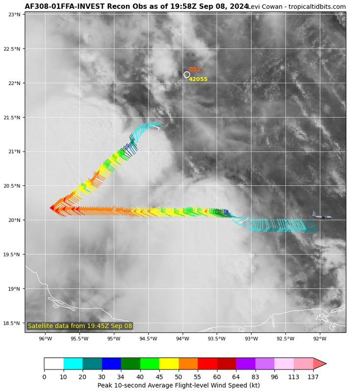
ColdMiser123 wrote:Recon is finding plenty of mid-grade TS wind. Wind shift near the center, but still a bit broad.

The structure matches model short-term forecasts that had the strongest wind on the southwest side of 91L.

Recon is flying at very low altitudes, so the flight level wind is just above the surface.


That stronger NW-NNW wind recon is finding is due to cool air rushing down the coast of Mexico behind the front, not from any circulation center. Such winds are common down there behind fronts.


Those front-related winds are helping to spark the circulation center via shear vorticity. The center will then begin to strengthen the pressure gradient to the southwest as it becomes better defined. So a bit of a chain reaction/positive feedback process taking place with this situation.
Last edited by ColdMiser123 on Sun Sep 08, 2024 2:28 pm, edited 1 time in total.
10 likes   
B.S., M.S., Meteorology & Atmospheric Science

User avatar
LadyBug72
Tropical Storm
Tropical Storm
Posts: 118
Joined: Mon Jun 01, 2020 3:39 pm
Location: about 20 miles from Galveston, Tx

Re: ATL: INVEST 91L - Discussion

#163 Postby LadyBug72 » Sun Sep 08, 2024 2:28 pm

wxman57 wrote:
LadyBug72 wrote:I’m about 20 miles from Galveston. I have family coming in from out of town Thursday for a funeral. What can we expect weather wise….still to early to tell? I’ve seen so many different stories. Thank you.


This system will be long gone by Thursday morning.


Thank you! Makes me feel better!
0 likes   
Formerly known as the user: Nikki

Alicia 83, Allison 01, Rita 05, Ike 08, Harvey 17, Nicholas 21, Coastal Texas Derecho 24, Beryl 24

User avatar
Teban54
Category 5
Category 5
Posts: 3204
Joined: Sat May 19, 2018 1:19 pm

Re: ATL: INVEST 91L - Discussion

#164 Postby Teban54 » Sun Sep 08, 2024 2:33 pm

Sciencerocks wrote:I'd named it and set it at 50 knts at 5pm.

What's the highest debut intensity for a newly designated TC? I can't imagine it's much higher than 50 kts.

Edit: One case I do remember is Don 2023, which was 45 kt when it first became a subtropical storm. Even though Advisory 1 expected the system to be at its peak, Don eventually became a hurricane.
Last edited by Teban54 on Sun Sep 08, 2024 2:42 pm, edited 1 time in total.
2 likes   

Craters
Category 1
Category 1
Posts: 421
Joined: Sat Aug 24, 2013 2:34 pm
Location: Alvin, TX (south of Houston)

Re: ATL: INVEST 91L - Discussion

#165 Postby Craters » Sun Sep 08, 2024 2:35 pm

ColdMiser123 wrote:
wxman57 wrote:
ColdMiser123 wrote:Recon is finding plenty of mid-grade TS wind. Wind shift near the center, but still a bit broad.

The structure matches model short-term forecasts that had the strongest wind on the southwest side of 91L.

Recon is flying at very low altitudes, so the flight level wind is just above the surface.


That stronger NW-NNW wind recon is finding is due to cool air rushing down the coast of Mexico behind the front, not from any circulation center. Such winds are common down there behind fronts.


Those front-related winds are helping to spark the circulation center via shear vorticity. The center will then begin to strengthen the pressure gradient to the southwest as it becomes better defined. So a bit of a chain reaction/positive feedback process taking place with this situation.

ColdMiser, Wxman, et al. -- How much will that shear help (hurt?) in pulling in that dry air to the west? I hate to keep harping on dry air here, but it's a factor that seems to be low on the list of interesting things to talk about. It's saved our bacon before, so I don't want to ignore it.
1 likes   
Nothing that I post here should ever be treated as a forecast or anything resembling one. Please check with your local NWS office or the NHC for forecasts, watches, and warnings.

Sciencerocks
Category 5
Category 5
Posts: 9155
Age: 39
Joined: Thu Jul 06, 2017 1:51 am

Re: ATL: INVEST 91L - Discussion

#166 Postby Sciencerocks » Sun Sep 08, 2024 2:48 pm

Teban54 wrote:
Sciencerocks wrote:I'd named it and set it at 50 knts at 5pm.

What's the highest debut intensity for a newly designated TC? I can't imagine it's much higher than 50 kts.


Noel is up there
https://www.nhc.noaa.gov/archive/2001/d ... s.001.html
3 likes   

psyclone
S2K Supporter
S2K Supporter
Posts: 4762
Joined: Wed Aug 24, 2005 9:04 pm
Location: palm harbor fl

Re: ATL: INVEST 91L - Discussion

#167 Postby psyclone » Sun Sep 08, 2024 2:51 pm

Seems like a "head on a swivel" situation for LA and probably MS as well. There's always the possibility of a peak season fast bloomer/overperformer....even more so when many of us have been lulled into complacency thanks to recency bias..
2 likes   

Sciencerocks
Category 5
Category 5
Posts: 9155
Age: 39
Joined: Thu Jul 06, 2017 1:51 am

Re: ATL: INVEST 91L - Discussion

#168 Postby Sciencerocks » Sun Sep 08, 2024 2:54 pm

Image
1 likes   

User avatar
Teban54
Category 5
Category 5
Posts: 3204
Joined: Sat May 19, 2018 1:19 pm

Re: ATL: INVEST 91L - Discussion

#169 Postby Teban54 » Sun Sep 08, 2024 2:55 pm

Sciencerocks wrote:
Teban54 wrote:
Sciencerocks wrote:I'd named it and set it at 50 knts at 5pm.

What's the highest debut intensity for a newly designated TC? I can't imagine it's much higher than 50 kts.


Noel is up there
https://www.nhc.noaa.gov/archive/2001/d ... s.001.html

Dang, a 65 kt hurricane on Advisory 1?

On the other hand, Noel 2001's best track shows that it spent a day as a subtropical storm before becoming a (tropical) hurricane, but was operationally considered a non-tropical low. In 2001, the naming policy was that subtropical storms would receive Greek Alphabet names, and be renamed to human names once they transition to tropical cyclones; that was changed in 2002, when subtropical storms started receiving numbers and human names off the bat. Regardless, it seems like even though the naming policy wouldn't have changed the operational intensity on Advisory 1, Noel 2001 should have ideally started at 45 kt -- that would not be the case with 91L if it's named at 50 kt.

(It's also quite a coincidence that Noel 2007 also became a November Cat 1 and reached that intensity in the subtropics, just like its predecessor. Noel 1995 also peaked as a Cat 1 in the subtropics, albeit in September. The name Noel was retired after 2007.)
Last edited by Teban54 on Sun Sep 08, 2024 3:02 pm, edited 1 time in total.
3 likes   

User avatar
wxman57
Moderator-Pro Met
Moderator-Pro Met
Posts: 22978
Age: 67
Joined: Sat Jun 21, 2003 8:06 pm
Location: Houston, TX (southwest)

Re: ATL: INVEST 91L - Discussion

#170 Postby wxman57 » Sun Sep 08, 2024 2:58 pm

xironman wrote:
wxman57 wrote:
cycloneye wrote:Recon will go this afternoon and we will know if they find a TD, TS or not yet a cyclone.


Any TS wind today is due to cool air accelerating down the coast of Mexico rather than due to the developing circulation. Winds have been 35 kts along the MX coast for over 24 hours. Very common behind a front.

It'll be important to see where the center sets up over the next 24 hours. That will play a part in the eventual track. It appears that the storm will encounter increasing westerly winds aloft as it moves across the NW Gulf Tue-Wed. Initially, that could aid outflow and help it to strengthen. Eventually, though, it'll become shear and result in weakening. 12Z Consensus shifted west to Lake Charles area, but I think it's going to track east of there, possibly as far east as western Vermilion Bay. Models are almost always too far west in these setups.

TS wind could pass offshore Brownsville on Tuesday, maybe very near the coast. That would require the NHC to initiate PTC advisories today. Maybe they'll wait for recon reports, though.


That's heck of a front

SFMR Peak (10s) Sfc. Wind: 48 kts (55.2 mph)


It's not uncommon to have winds of 50 kts down the coast of Mexico following a frontal passage. They're particularly strong with fronts earlier in the season due to the very warm water. The go right down the coast against the mountains then swirl around in the BoC. Those winds should subside by tomorrow as cold air advection ends.
0 likes   

MarioProtVI
Category 4
Category 4
Posts: 935
Age: 24
Joined: Sun Sep 29, 2019 7:33 pm
Location: New Jersey

Re: ATL: SIX: Potential Tropical Cyclone - Discussion (18z Best Track has POTC)

#171 Postby MarioProtVI » Sun Sep 08, 2024 2:59 pm

AL, 06, 2024090818, , BEST, 0, 214N, 945W, 45, 1003, LO, 34, NEQ, 0, 0, 140, 160, 1008, 180, 100, 0, 0, L, 0, , 0, 0, SIX, S, 0, , 0, 0, 0, 0, genesis-num, 014, TRANSITIONED, alC12024 to al062024,
Last edited by MarioProtVI on Sun Sep 08, 2024 3:00 pm, edited 1 time in total.
2 likes   

User avatar
Steve
S2K Supporter
S2K Supporter
Posts: 9620
Joined: Sat Apr 05, 2003 11:41 pm
Location: Not a state-caster

Re: ATL: INVEST 91L - Discussion

#172 Postby Steve » Sun Sep 08, 2024 2:59 pm

Craters wrote:
ColdMiser123 wrote:
wxman57 wrote:
That stronger NW-NNW wind recon is finding is due to cool air rushing down the coast of Mexico behind the front, not from any circulation center. Such winds are common down there behind fronts.


Those front-related winds are helping to spark the circulation center via shear vorticity. The center will then begin to strengthen the pressure gradient to the southwest as it becomes better defined. So a bit of a chain reaction/positive feedback process taking place with this situation.

ColdMiser, Wxman, et al. -- How much will that shear help (hurt?) in pulling in that dry air to the west? I hate to keep harping on dry air here, but it's a factor that seems to be low on the list of interesting things to talk about. It's saved our bacon before, so I don't want to ignore it.


I don’t think the dry air matters that much because it’s an enhancing wind blowing in the right direction for a circulation forming to its east. Jmo.
1 likes   

User avatar
Teban54
Category 5
Category 5
Posts: 3204
Joined: Sat May 19, 2018 1:19 pm

Re: ATL: INVEST 91L - Discussion

#173 Postby Teban54 » Sun Sep 08, 2024 3:00 pm

MarioProtVI wrote:
AL, 06, 2024090818, , BEST, 0, 214N, 945W, 45, 1003, LO, 34, NEQ, 0, 0, 140, 160, 1008, 180, 100, 0, 0, L, 0, , 0, 0, SIX, S, 0, , 0, 0, 0, 0, genesis-num, 014, TRANSITIONED, alC12024 to al062024,

Does this mean PTC if it's in the best track as "Tropical Low Six"? Can't remember this being done for past PTCs, but I wasn't paying attention to this back then.

Also, what the heck is "alC12024"?
Last edited by Teban54 on Sun Sep 08, 2024 3:01 pm, edited 1 time in total.
0 likes   

wx98
Category 5
Category 5
Posts: 1383
Joined: Sat Aug 25, 2018 9:24 pm

Re: ATL: INVEST 91L - Discussion

#174 Postby wx98 » Sun Sep 08, 2024 3:01 pm

NHC has a Cat 1 into the Lake Charles area Wednesday night.
0 likes   

Frank P
S2K Supporter
S2K Supporter
Posts: 2776
Joined: Fri Aug 29, 2003 10:52 am
Location: Biloxi Beach, Ms
Contact:

Re: ATL: INVEST 91L - Discussion

#175 Postby Frank P » Sun Sep 08, 2024 3:03 pm

wx98 wrote:NHC has a Cat 1 into the Lake Charles area Wednesday night.

where did you get that info?
1 likes   

MarioProtVI
Category 4
Category 4
Posts: 935
Age: 24
Joined: Sun Sep 29, 2019 7:33 pm
Location: New Jersey

Re: ATL: INVEST 91L - Discussion

#176 Postby MarioProtVI » Sun Sep 08, 2024 3:03 pm

Teban54 wrote:
MarioProtVI wrote:
AL, 06, 2024090818, , BEST, 0, 214N, 945W, 45, 1003, LO, 34, NEQ, 0, 0, 140, 160, 1008, 180, 100, 0, 0, L, 0, , 0, 0, SIX, S, 0, , 0, 0, 0, 0, genesis-num, 014, TRANSITIONED, alC12024 to al062024,

Does this mean PTC if it's in the best track as "Tropical Low Six"? Can't remember this being done for past PTCs, but I wasn't paying attention to this back then.

Also, what the heck is "alC12024"?

Yes, whenever it has the numerical name in the data but does not say TS or TD, then it is a POTC. They’ve done this before.

wx98 wrote:NHC has a Cat 1 into the Lake Charles area Wednesday night.

No they don’t? Where are you finding this?
1 likes   

User avatar
Teban54
Category 5
Category 5
Posts: 3204
Joined: Sat May 19, 2018 1:19 pm

Re: ATL: INVEST 91L - Discussion

#177 Postby Teban54 » Sun Sep 08, 2024 3:06 pm

So we now have two LLCs or vorts each with its own robust hot towers... This is gonna be fun.

Image
1 likes   

sphelps8681
Category 2
Category 2
Posts: 785
Joined: Thu Aug 16, 2007 5:37 pm
Location: Somewhere over the rainbow

Re: ATL: INVEST 91L - Discussion

#178 Postby sphelps8681 » Sun Sep 08, 2024 3:07 pm

When will we know more info on future track? Thanks
0 likes   

User avatar
Teban54
Category 5
Category 5
Posts: 3204
Joined: Sat May 19, 2018 1:19 pm

Re: ATL: INVEST 91L - Discussion

#179 Postby Teban54 » Sun Sep 08, 2024 3:09 pm

sphelps8681 wrote:When will we know more info on future track? Thanks

It seems very likely that NHC will designate this as Potential Tropical Cyclone Six in an hour, and by then they will release official advisories including their track and intensity forecasts. It's always the best to follow official information (even though discussions here and model runs can be useful).
The posts in this forum are NOT official forecasts and should not be used as such. They are just the opinion of the poster and may or may not be backed by sound meteorological data. They are NOT endorsed by any professional institution or STORM2K. For official information, please refer to products from the NHC and NWS.
3 likes   

User avatar
Steve
S2K Supporter
S2K Supporter
Posts: 9620
Joined: Sat Apr 05, 2003 11:41 pm
Location: Not a state-caster

Re: ATL: INVEST 91L - Discussion

#180 Postby Steve » Sun Sep 08, 2024 3:09 pm

Teban54 wrote:So we now have two LLCs or vorts each with its own robust hot towers... This is gonna be fun.

https://i.postimg.cc/zvd1NCJH/image.png


Yeah rules from a fan standpoint. Kinda can’t wait for DMAX honestly.
0 likes   


Return to “2024”

Who is online

Users browsing this forum: No registered users and 1 guest