ATL: MILTON - Models
Moderator: S2k Moderators

Re: ATL: FOURTEEN - Models
Wrong thread.
0 likes
Not a professional meteorologist. Please refer to NHC forecasts for official information/advice relating to tropical systems.


Re: ATL: FOURTEEN - Models
StPeteMike wrote:redingtonbeach wrote:Hmmm.. Orlando newspaper says the NHC has indicated a major hurricane is possible. Hmmmm…
Fear mongering? Or, fact they actually said that?
https://postimg.cc/hhNTfNH5
They’ve kept the door open but the 11 am has Cat 2…. but literally 1 mph difference between 2 and 3.
The 11 am NHC Key Messages: “ The depression is forecast to quickly intensify while it moves eastward to northeastward
across the Gulf of Mexico and be at or near major hurricane strength when it reaches the west coast
of the Florida Peninsula mid week.”
Last edited by LCfromFL on Sat Oct 05, 2024 11:31 am, edited 1 time in total.
3 likes
-
BIFF_THE_UNRULY
- Tropical Storm

- Posts: 143
- Joined: Fri Jun 28, 2024 2:12 pm
Re: ATL: FOURTEEN - Models
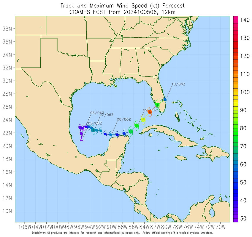
SFLcane wrote:https://i.postimg.cc/D0yLxK9s/comaps.jpg
That would be the best outcome..or maybe even a little further south. Mostly swamps
1 likes
-
AutoPenalti
- Category 5

- Posts: 4091
- Age: 29
- Joined: Mon Aug 17, 2015 4:16 pm
- Location: Ft. Lauderdale, Florida
Re: ATL: FOURTEEN - Models
SFLcane wrote:https://i.postimg.cc/D0yLxK9s/comaps.jpg
i’ve forgotten about the COAMPS… now i know why
1 likes
The posts in this forum are NOT official forecasts and should not be used as such. They are just the opinion of the poster and may or may not be backed by sound meteorological data. They are NOT endorsed by any professional institution or STORM2K. For official information, please refer to products from the NHC and NWS.
Model Runs Cheat Sheet:
GFS (5:30 AM/PM, 11:30 AM/PM)
HWRF, GFDL, UKMET, NAVGEM (6:30-8:00 AM/PM, 12:30-2:00 AM/PM)
ECMWF (1:45 AM/PM)
TCVN is a weighted averaged

Re: ATL: FOURTEEN - Models
SFLcane wrote:https://i.postimg.cc/pTB19RQn/vvvv.jpg
The NHC is going with the further north track Tampa to Daytona track due to a more intense storm.
1 likes

-
gatorcane

- S2K Supporter

- Posts: 23708
- Age: 48
- Joined: Sun Mar 13, 2005 3:54 pm
- Location: Boca Raton, FL
Re: ATL: FOURTEEN - Models
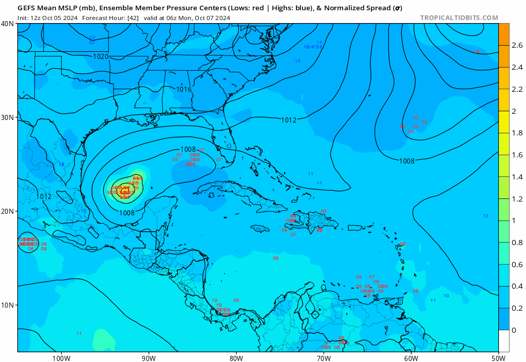
12Z GFS Ensembles are pretty tightly clustered around the Tampa area and in decent agreement with the GFS OP:
4 likes
-
toad strangler

- S2K Supporter
- Posts: 4546
- Joined: Sun Jul 28, 2013 3:09 pm
- Location: Earth
- Contact:
Re: ATL: FOURTEEN - Models
gatorcane wrote:12Z GFS Ensembles are pretty tightly clustered around the Tampa area and in decent agreement with the GFS OP:
https://i.postimg.cc/tJ4bhSWW/gfs-ememb-lowlocs-watl-fh42-114.gif
That’s not tightly clustered at landfall. That’s a large spread of FL west coastline.
5 likes
My Weather Station
https://www.wunderground.com/dashboard/pws/KFLPORTS603
https://www.wunderground.com/dashboard/pws/KFLPORTS603

Re: ATL: FOURTEEN - Models
The next two days will make things quite clear. The GFS and hurricane models are calling for rapid gains in latitude as soon as it gets going east. ICON, CMC not as drastic.
0 likes
Andrew (1992), Irene (1999), Frances (2004), Katrina (2005), Wilma (2005), Fay (2008), Irma (2017), Eta (2020), Ian (2022)
-
gatorcane
- S2K Supporter
- Posts: 23708
- Age: 48
- Joined: Sun Mar 13, 2005 3:54 pm
- Location: Boca Raton, FL
Re: ATL: FOURTEEN - Models
12Z UKMET has shifted north some and a little stronger, comes into Naples and exits around Jupiter. Looks like "stronger = more north" for this storm:
0 likes

Re: ATL: FOURTEEN - Models
12z HMON and HAFS-A/B have a hurricane by tomorrow afternoon. However, it looks fairly sloppy. HAFS simulated IR views are not impressive and the HMON has possible dry air entrainment.
0 likes
Irene '11 Sandy '12 Hermine '16 5/15/2018 Derecho Fay '20 Isaias '20 Elsa '21 Henri '21 Ida '21
I am only a meteorology enthusiast who knows a decent amount about tropical cyclones. Look to the professional mets, the NHC, or your local weather office for the best information.
I am only a meteorology enthusiast who knows a decent amount about tropical cyclones. Look to the professional mets, the NHC, or your local weather office for the best information.

Re: ATL: FOURTEEN - Models
boca wrote:SFLcane wrote:https://i.postimg.cc/pTB19RQn/vvvv.jpg
The NHC is going with the further north track Tampa to Daytona track due to a more intense storm.
I thought the major determining factor of how far north this goes was going to be the frontal trough.
1 likes
Personal Forecast Disclaimer:
My posts are just my opinion and are most likely not backed by sound meteorological data. They are NOT endorsed by any professional institution or storm2k.org. For official information, please refer to the NHC and NWS products.
Bottom line is that I am just expressing my opinion!!!
My posts are just my opinion and are most likely not backed by sound meteorological data. They are NOT endorsed by any professional institution or storm2k.org. For official information, please refer to the NHC and NWS products.
Bottom line is that I am just expressing my opinion!!!
-
redingtonbeach
- Tropical Depression

- Posts: 65
- Joined: Mon Sep 04, 2017 12:05 am
Re: ATL: FOURTEEN - Models
SFLcane wrote:https://i.postimg.cc/D0yLxK9s/comaps.jpg
That Navy model has done exceptionally well on intensity over the years. Location I don’t know how it has done.
0 likes
-
eastcoastFL

- Category 5
- Posts: 3996
- Age: 44
- Joined: Thu Apr 12, 2007 12:29 pm
- Location: Palm City, FL
Re: ATL: FOURTEEN - Models
US Navy Tropical Cyclone map TD14

2 likes
Personal Forecast Disclaimer:
The posts in this forum are NOT official forecast and should not be used as such. They are just the opinion of the poster and may or may not be backed by sound meteorological data. They are NOT endorsed by any professional institution or storm2k.org. For official information, please refer to the NHC and NWS products.
The posts in this forum are NOT official forecast and should not be used as such. They are just the opinion of the poster and may or may not be backed by sound meteorological data. They are NOT endorsed by any professional institution or storm2k.org. For official information, please refer to the NHC and NWS products.
-
eastcoastFL
- Category 5
- Posts: 3996
- Age: 44
- Joined: Thu Apr 12, 2007 12:29 pm
- Location: Palm City, FL
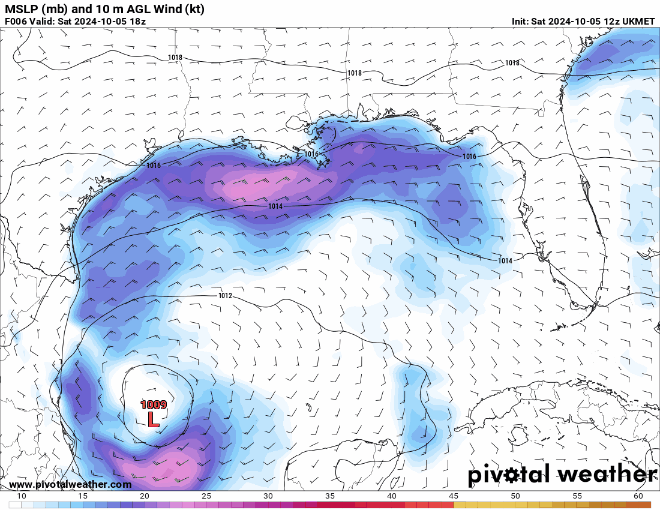
Re: ATL: FOURTEEN - Models
gatorcane wrote:12Z UKMET has shifted north some and a little stronger, comes into Naples and exits around Jupiter. Looks like "stronger = more north" for this storm:
https://i.postimg.cc/fR93PKgY/floop-ukmet-2024100512-sfcwind-mslp-gom.gif
A stronger storm goes north BUT the heavy shear is also north. So either the shear is expected to lift out or a stronger storm could weaken as it turns NE if the shear is still there, right?
2 likes
Personal Forecast Disclaimer:
The posts in this forum are NOT official forecast and should not be used as such. They are just the opinion of the poster and may or may not be backed by sound meteorological data. They are NOT endorsed by any professional institution or storm2k.org. For official information, please refer to the NHC and NWS products.
The posts in this forum are NOT official forecast and should not be used as such. They are just the opinion of the poster and may or may not be backed by sound meteorological data. They are NOT endorsed by any professional institution or storm2k.org. For official information, please refer to the NHC and NWS products.
Re: ATL: MILTON - Models
HAFS-B peaks at 145 kt/919 mbar on Tuesday night despite increasing shear.
HWRF begins RI much sooner than the HAFS models. Takes about a day to organize, then goes bananas north of the Yucatan. It’s also the furthest south of the three models, which keeps it away from the shear and gives it a little more time.
HWRF begins RI much sooner than the HAFS models. Takes about a day to organize, then goes bananas north of the Yucatan. It’s also the furthest south of the three models, which keeps it away from the shear and gives it a little more time.
1 likes
Irene '11 Sandy '12 Hermine '16 5/15/2018 Derecho Fay '20 Isaias '20 Elsa '21 Henri '21 Ida '21
I am only a meteorology enthusiast who knows a decent amount about tropical cyclones. Look to the professional mets, the NHC, or your local weather office for the best information.
I am only a meteorology enthusiast who knows a decent amount about tropical cyclones. Look to the professional mets, the NHC, or your local weather office for the best information.
-
ConvergenceZone
.gif)
- Category 5
- Posts: 5241
- Joined: Fri Jul 29, 2005 1:40 am
- Location: Northern California
Re: ATL: MILTON - Models
aspen wrote:HAFS-B peaks at 145 kt/919 mbar on Tuesday night despite increasing shear.
HWRF begins RI much sooner than the HAFS models. Takes about a day to organize, then goes bananas north of the Yucatan. It’s also the furthest south of the three models, which keeps it away from the shear and gives it a little more time.
Hurricanes this season haven't really cared much about shear. I think it was Francine that suppose to have weakened quite a bit due to shear. The shear was there, but the storm didn't weaken. I just no longer trust shear maps. The storm is going to do what it's going to do.
3 likes
Who is online
Users browsing this forum: No registered users and 63 guests