ATL: MILTON - Models
Moderator: S2k Moderators
-
Flwxguy86

- Tropical Depression

- Posts: 51
- Age: 39
- Joined: Sun Sep 15, 2024 11:06 am
- Location: Oldsmar,FL
Re: ATL: MILTON - Models
When is it forecasted to speed up?, I think it is actually going slower by 1-2mph than it previously was, If it doesn't speed up soon, it's gonna be more like 5-6am thursday morning.
1 likes

Re: ATL: MILTON - Models
I actually watched a video saying it could be 5 or 6am thursday morning.
2 likes
Robbielyn McCrary
I know just about enough to sound like I know what I'm talking about sometimes. But for your safety please follow the nhc for truly professional forecasting.
I know just about enough to sound like I know what I'm talking about sometimes. But for your safety please follow the nhc for truly professional forecasting.

Re: ATL: MILTON - Models
floridasun wrote:are their lastest ? when new run come out? i seen one post their nowSteve wrote:floridasun wrote:when new Ensembles come out see if keep sifting south? like fort myers area
?
GEFS and GEPS are available. EPS usually comes out later but people with paid access or subscriptions get it earlier.
They have better graphics out there than Levi's, but
GEFS https://www.tropicaltidbits.com/analysi ... 00812&fh=0
GEPS https://www.tropicaltidbits.com/analysi ... 00800&fh=0
FWIW I never knew the GEPS was run by the JMA (Japanese Meteorological Agency. Guess I should have known that all along.
Only GEFS is latest and will come out again after the 18z GFS runs. So late this afternoon.
GEPS is running now on Tidbits. It hasn’t filled in any of the time points though so you might have to wait 15 minutes or so for the 42 hours. Oh wait it just filled in. Here you go (also only runs 00z and 12z).
https://www.tropicaltidbits.com/analysi ... 00812&fh=6
European 06z is now loaded as well. Remember these start 3 days before so you gotta move up to 00z and then press play if you don’t want to see the older times.
https://www.tropicaltidbits.com/analysi ... 00806&fh=0
0 likes

Re: ATL: MILTON - Models
Just an FYI, with 42 hrs prior to landfall how left biased the Euro ensembles were with Helene while the operational was to the right over their mean.

0 likes
Re: ATL: MILTON - Models
Yep, it always thrown them off.
12z HAFS-A did a nice job forecasting its current position but it still has it making landfall in Pinellas County.
0 likes
-
SFLcane

- S2K Supporter

- Posts: 10281
- Age: 48
- Joined: Sat Jun 05, 2010 1:44 pm
- Location: Lake Worth Florida
Re: ATL: MILTON - Models
Hurricane watch WPB? 
Last edited by SFLcane on Tue Oct 08, 2024 2:10 pm, edited 1 time in total.
0 likes

Re: ATL: MILTON - Models
The GFS had a ridge scenario that was too strong at the 500 mb steering level.
This was the old forecast where you can see the 582 Isobar wrapping up to JAX.

This is todays 12Z GFS with storm in same position, the 582 Isobar has been backed off south of lake Okeechobee.

12Z GFS has Milton crossing 23N at -87W.
Good longer term benchmark Milton may track a little south of there due to core wobbles or the weakening ridge could become a trend.
1 likes
Re: ATL: MILTON - Models
Big shift to the south as I also anticipated because of "unexpected" ESE jog.
I can see the Tampa TV Mets saying Tampa looks to be getting closer and closer into the clear.

I can see the Tampa TV Mets saying Tampa looks to be getting closer and closer into the clear.
2 likes
Re: ATL: MILTON - Models
NDG wrote:Big shift to the south as I also anticipated because of "unexpected" ESE jog.
I can see the Tampa TV Mets saying Tampa looks to be getting closer and closer into the clear.
https://i.imgur.com/JTubdtK.gif
Watch this shift back north after the HAFS effect kicks in, this just looks like a last minute best track induced shift. We'll be able to tell if it's heading back more north in a few hours.
1 likes
-
chris_fit

- Category 5

- Posts: 3261
- Age: 43
- Joined: Wed Sep 10, 2003 11:58 pm
- Location: Tampa Bay Area, FL
Re: ATL: MILTON - Models
Wow - Another Irma, Charley, Ian, etc.? Looking a littttle better for Tampa Bay region, not nearly out of the woods but what a nice trend for the bay area.
2 likes
Re: ATL: MILTON - Models
chris_fit wrote:Wow - Another Irma, Charley, Ian, etc.? Looking a littttle better for Tampa Bay region, not nearly out of the woods but what a nice trend for the bay area.
Until I see the reliable global & hurricane models jump on board with such a shift I personally would not say that Tampa is out of the woods.
4 likes
Re: ATL: MILTON - Models
Shear not destrutive until 36
* GFS version *
* ATLANTIC 2024 SHIPS INTENSITY FORECAST *
* IR SAT DATA AVAILABLE, OHC AVAILABLE *
* MILTON AL142024 10/08/24 18 UTC *
TIME (HR) 0 6 12 18 24 36 48 60 72 84 96 108 120 132 144 156 168
SHEAR (KT) 11 14 18 19 22 33 34 48 47 47 31 27 31 N/A N/A N/A N/A
SHEAR ADJ (KT) 6 7 8 7 8 3 7 7 7 6 8 5 4 N/A N/A N/A N/A
SHEAR DIR 191 205 219 229 224 247 252 246 246 259 254 254 240 N/A N/A N/A
0 likes
-
TampaWxLurker
- Tropical Storm

- Posts: 196
- Joined: Thu Aug 01, 2024 8:20 am
Re: ATL: MILTON - Models
I'm superstitious for no reason other than superstition. Please don't jinx it.
I also need to see the trends continue on the models to fully buy it. Before I breathe any sigh of relief.
It's also going to be a much larger storm by then so it would need to move significantly south before people on the south or east sides of Hillsborough County escape hurricane force winds.
I also need to see the trends continue on the models to fully buy it. Before I breathe any sigh of relief.
It's also going to be a much larger storm by then so it would need to move significantly south before people on the south or east sides of Hillsborough County escape hurricane force winds.
1 likes

Re: ATL: MILTON - Models
BobHarlem wrote:NDG wrote:Big shift to the south as I also anticipated because of "unexpected" ESE jog.
I can see the Tampa TV Mets saying Tampa looks to be getting closer and closer into the clear.
https://i.imgur.com/JTubdtK.gif
Watch this shift back north after the HAFS effect kicks in, this just looks like a last minute best track induced shift. We'll be able to tell if it's heading back more north in a few hours.
If I'm reading the HAS-A correctly, it saw this jog and is about dead on with this location at this time. It showed Milton being at 22.5/88.6 at 15Z. Just my amateur observation, but the hurricane models seem to have seen this coming and still end up in roughly the same place. Will see what happens when the pro's speak in an hour or so.
2 likes
-
Coolcruiseman
- Tropical Depression
- Posts: 97
- Age: 52
- Joined: Wed Sep 21, 2022 8:10 pm
- Location: Melbourne, FL
Re: ATL: MILTON - Models
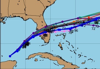
NDG wrote:12z Euro zoomed in, landfall Longboat Key Bradenton/Sarasota then ENE towards Melbourne/Cocoa Beach.
https://i.imgur.com/77bu0MC.gif
So basically where the NHC track had it Sunday (at least for the East Coast exit).
0 likes
Re: ATL: MILTON - Models
I'm a little confused ... the most recent runs (12z) of the models utilized by the NHC (GFS, HAFS, Euro) all show Milton basically dead on top of Tampa Bay.
Why are there rumblings of Tampa being in the "all clear"?
Why are there rumblings of Tampa being in the "all clear"?
2 likes

Re: ATL: MILTON - Models
Lance wrote:BobHarlem wrote:NDG wrote:Big shift to the south as I also anticipated because of "unexpected" ESE jog.
I can see the Tampa TV Mets saying Tampa looks to be getting closer and closer into the clear.
https://i.imgur.com/JTubdtK.gif
Watch this shift back north after the HAFS effect kicks in, this just looks like a last minute best track induced shift. We'll be able to tell if it's heading back more north in a few hours.
If I'm reading the HAS-A correctly, it saw this jog and is about dead on with this location at this time. It showed Milton being at 22.5/88.6 at 15Z. Just my amateur observation, but the hurricane models seem to have seen this coming and still end up in roughly the same place. Will see what happens when the pro's speak in an hour or so.
yes HAFS-A also had almost this exact track from last run.. almost exact even. I know nobody wants this to go to Tampa but I wouldn't put my guard down for a second there... too many runs.
0 likes
-
Poonwalker
- Category 1

- Posts: 270
- Joined: Tue Sep 20, 2022 11:12 am
Re: ATL: MILTON - Models
Edited to stay on topic. Any south shift in modeling is going to have to pass the repeatability test before NHC makes any major adjustments. That said, Tampa will only be in the clear when Hurricane force wind probabilities come way down. There is still danger on the north core even if the bay is spared the horrendous surge. I would also add a more southern shift might allow Milton to avoid higher shear values and support higher category winds in the outer core.
Last edited by Poonwalker on Tue Oct 08, 2024 3:26 pm, edited 3 times in total.
0 likes
Who is online
Users browsing this forum: No registered users and 105 guests