ATL: DEBBY - Models

Moderator: S2k Moderators

Message
Author
TomballEd
Category 2
Category 2
Posts: 688
Age: 61
Joined: Wed Aug 16, 2023 4:52 pm
Location: Spring/Klein area, not Tomball

Re: ATL: INVEST 97L - Models

#101 Postby TomballEd » Fri Aug 02, 2024 1:54 am

BobHarlem wrote:Hafs A and b:

A didn't get lost this time but both struggled with genesis.
HafsA loops and stalls near the Big Bend and never leaves north Florida for the rest of the run.
https://i.imgur.com/118hbDI.png
https://i.imgur.com/4c2gAns.png


HafsB, faster, right of prior run. But stalls here for about 24 hours before moving slightly further north, but still in Florida (Just south of GA border) by hour 117 the drifts back closer to the Gulf/Big Bend by the end of the run on 0z Wed.
https://i.imgur.com/fFer68a.png


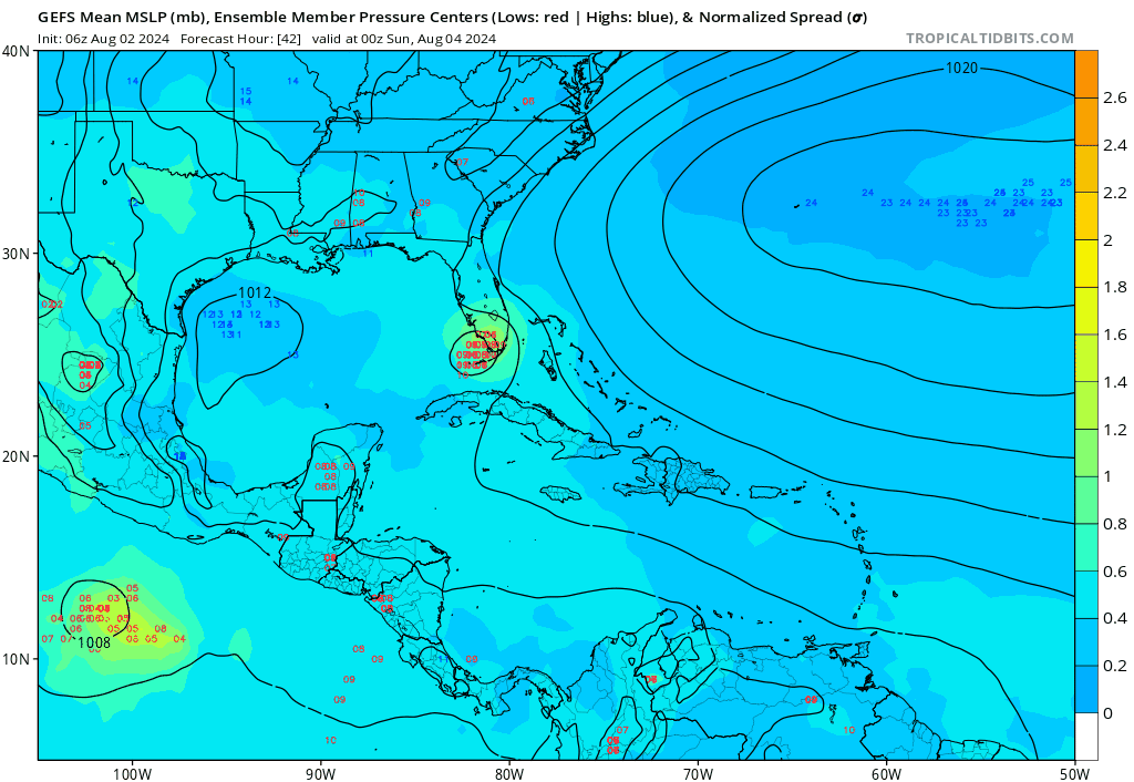
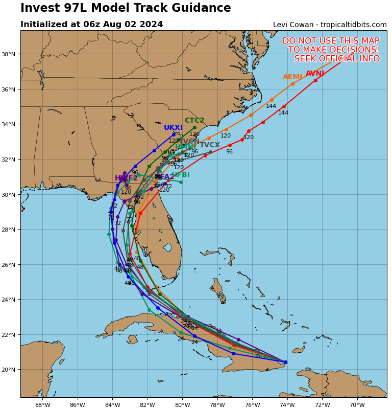
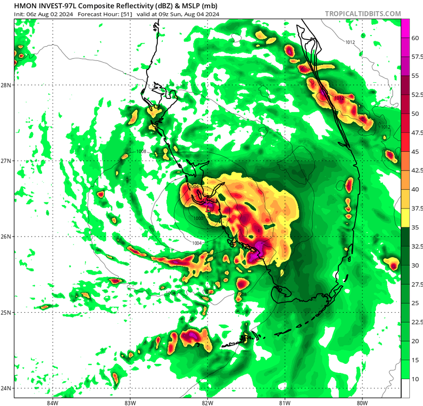
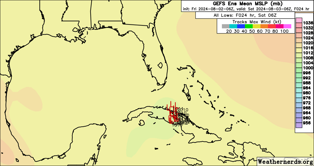
Dr. Andy Hazelton, one of the HAFS developers at HRD, has a pinned tweet saying the high res hurricane models are not reliable before a coherent center forms. With caveats of no coherent center having formed yet, the trend of the models at 0Z is further E with less time over water, and any stall happens over the Atlantic. Intensity on the models have also trended down. Does anybody know how to find the SHIPS run with Euro input? NHC mentions it from time to time, it exists. It may be like the old FSU Super Ensemble, not for public consumption.
1 likes   

User avatar
SFLcane
S2K Supporter
S2K Supporter
Posts: 10163
Age: 47
Joined: Sat Jun 05, 2010 1:44 pm
Location: Lake Worth Florida

Re: ATL: INVEST 97L - Models

#102 Postby SFLcane » Fri Aug 02, 2024 4:50 am

06z gfs goes over keys and near fort Myers up the west coast of Florida.
0 likes   

jlauderdal
S2K Supporter
S2K Supporter
Posts: 7182
Joined: Wed May 19, 2004 5:46 am
Location: NE Fort Lauderdale
Contact:

Re: ATL: INVEST 97L - Models

#103 Postby jlauderdal » Fri Aug 02, 2024 5:08 am

SFLcane wrote:06z gfs goes over keys and near Fort Myers up the west coast of Florida.

Trending east, but it's the op, so we need to be careful in this situation. I have the pumps ready to go. Tracking is one thing, but where rain sets up is far more difficult to predict. We have pwats going to at least 2.3 so more than ample juice and plenty of lift to make flooding rains anywhere in sofla. Still, 60 days to go to get to Oct 1(oct busiest month on average for FL), so there is a long way to go for Floridians.
0 likes   

User avatar
SFLcane
S2K Supporter
S2K Supporter
Posts: 10163
Age: 47
Joined: Sat Jun 05, 2010 1:44 pm
Location: Lake Worth Florida

Re: ATL: INVEST 97L - Models

#104 Postby SFLcane » Fri Aug 02, 2024 5:15 am

jlauderdal wrote:
SFLcane wrote:06z gfs goes over keys and near Fort Myers up the west coast of Florida.

Trending east, but it's the op, so we need to be careful in this situation. I have the pumps ready to go. Tracking is one thing, but where rain sets up is far more difficult to predict. We have pwats going to at least 2.3 so more than ample juice and plenty of lift to make flooding rains anywhere in sofla. Still, 60 days to go to get to Oct 1(oct busiest month on average for FL), so there is a long way to go for Floridians.


The trend is east since last night. Gefs has a good chunk over the westcoast heading north.

Image
1 likes   

User avatar
N2FSU
S2K Supporter
S2K Supporter
Posts: 1062
Joined: Thu Sep 04, 2003 2:04 pm
Location: Tallahassee, FL

Re: ATL: INVEST 97L - Models

#105 Postby N2FSU » Fri Aug 02, 2024 5:19 am

6z GFS

Image
Image
0 likes   

User avatar
robbielyn
Category 5
Category 5
Posts: 1298
Joined: Wed May 07, 2003 9:45 am
Location: brooksville, fl

Re: ATL: INVEST 97L - Models

#106 Postby robbielyn » Fri Aug 02, 2024 6:01 am

GFS tampa st pete and really weak hopefully this pans out and be just a rainmaker
0 likes   
Robbielyn McCrary
I know just about enough to sound like I know what I'm talking about sometimes. But for your safety please follow the nhc for truly professional forecasting. :D

BobHarlem
Category 5
Category 5
Posts: 2098
Joined: Thu Oct 20, 2005 6:11 pm

Re: ATL: INVEST 97L - Models

#107 Postby BobHarlem » Fri Aug 02, 2024 6:19 am

6z earlies were all concentrated between Perry and Bradenton, UK met moved into that group as well. TVCN is Cedar Key. Although watch for that initial center point to change because Cuba.

Image

Today is the model test versus Cuba.
Last edited by BobHarlem on Fri Aug 02, 2024 7:24 am, edited 1 time in total.
0 likes   

User avatar
toad strangler
S2K Supporter
S2K Supporter
Posts: 4543
Joined: Sun Jul 28, 2013 3:09 pm
Location: Earth
Contact:

Re: ATL: INVEST 97L - Models

#108 Postby toad strangler » Fri Aug 02, 2024 7:05 am

6z Euro into Cedar Key with what is probably a Tropical Storm.
0 likes   

User avatar
robbielyn
Category 5
Category 5
Posts: 1298
Joined: Wed May 07, 2003 9:45 am
Location: brooksville, fl

Re: ATL: INVEST 97L - Models

#109 Postby robbielyn » Fri Aug 02, 2024 7:37 am

It's always sloppy when its progged to hit north west coast always. Which I am thankful for. Thats why its been over a 100 years since we got hit with a hurricane. Hurricanes like panhandle and s fl.
0 likes   
Robbielyn McCrary
I know just about enough to sound like I know what I'm talking about sometimes. But for your safety please follow the nhc for truly professional forecasting. :D

BobHarlem
Category 5
Category 5
Posts: 2098
Joined: Thu Oct 20, 2005 6:11 pm

Re: ATL: INVEST 97L - Models

#110 Postby BobHarlem » Fri Aug 02, 2024 7:37 am

Shift right on the 12z earlies TVCN over St. Pete.

Gonna call out that this is based on the 12z best track, which may be too far north (wait and see).

Image
Last edited by BobHarlem on Fri Aug 02, 2024 8:00 am, edited 1 time in total.
0 likes   

pcolaman
Category 1
Category 1
Posts: 380
Age: 61
Joined: Sun Aug 29, 2010 9:33 am
Location: Pensacola Fla

Re: ATL: INVEST 97L - Models

#111 Postby pcolaman » Fri Aug 02, 2024 7:52 am

BobHarlem wrote:Shift right on may the 12z earlies TVCN over St. Pete.

Gonna call out that this is based on the 12z best track, which may be too far north (wait and see).

https://i.imgur.com/1lMEqHT.png


Agree that it's to far south. The shredded has done it's job so far. Will be interesting to see how the storm reacts once it clear Cuba tonight.
0 likes   

User avatar
cycloneye
Admin
Admin
Posts: 145274
Age: 68
Joined: Thu Oct 10, 2002 10:54 am
Location: San Juan, Puerto Rico

Re: ATL: INVEST 97L - Models

#112 Postby cycloneye » Fri Aug 02, 2024 7:54 am

Image
1 likes   
Visit the Caribbean-Central America Weather Thread where you can find at first post web cams,radars
and observations from Caribbean basin members Click Here

User avatar
Hypercane_Kyle
Category 5
Category 5
Posts: 3352
Joined: Sat Mar 07, 2015 7:58 pm
Location: Cape Canaveral, FL

Re: ATL: INVEST 97L - Models

#113 Postby Hypercane_Kyle » Fri Aug 02, 2024 7:55 am

Expect the consensus to shift quite a bit once the LLC develops, which will in turn have large implications on intensity.
0 likes   
My posts are my own personal opinion, defer to the National Hurricane Center (NHC) and other NOAA products for decision making during hurricane season.

User avatar
SFLcane
S2K Supporter
S2K Supporter
Posts: 10163
Age: 47
Joined: Sat Jun 05, 2010 1:44 pm
Location: Lake Worth Florida

Re: ATL: INVEST 97L - Models

#114 Postby SFLcane » Fri Aug 02, 2024 7:58 am

Another bump east…

Image
0 likes   

BIFF_THE_UNRULY
Tropical Storm
Tropical Storm
Posts: 143
Joined: Fri Jun 28, 2024 2:12 pm

Re: ATL: INVEST 97L - Models

#115 Postby BIFF_THE_UNRULY » Fri Aug 02, 2024 8:19 am

DunedinDave wrote:
IcyTundra wrote:18Z GFS through 96 hours. Nearly 200 miles ENE of the 12Z run so far.
https://i.ibb.co/R2yZW8q/gfs-mslp-pcpn-watl-fh6-96.gif


That’s better news for Tampa area. Seems to move in and out quick and is just mostly a rainmaker as opposed to stalling out along the coast. Hopefully it then moves out to sea.


i dont know we could probably use a bit more rain
0 likes   

Jelmergraaff
Tropical Storm
Tropical Storm
Posts: 137
Age: 22
Joined: Fri Aug 27, 2021 1:00 pm
Location: The Netherlands

Re: ATL: INVEST 97L - Models

#116 Postby Jelmergraaff » Fri Aug 02, 2024 8:36 am

Here's the - perhaps somewhat outdated - overview of the 00z AI-model runs. From top-left to bottom-right: AIFS, FourCastNet, GraphCast and PanguWeather. All of them have 97L making landfall somewhere between Spring Hill and Ochlockonee Bay in about 60 hours. The same holds for AIFS 06z. Please ignore the intensities. Charts are from ECMWF.

Edit: And at +120 hours, so Wednesday at 00 UTC, almost all of them show 97L (or future Debby) on or just off the coast of the Carolina's.


0 likes   
21-year old meteorologist and student MSc Climate Studies from The Netherlands. Interested in all fields of meteorology and climatology, including tropical systems like hurricanes.

User avatar
SFLcane
S2K Supporter
S2K Supporter
Posts: 10163
Age: 47
Joined: Sat Jun 05, 2010 1:44 pm
Location: Lake Worth Florida

ATL: INVEST 97L - Discussion (60/90)

#117 Postby SFLcane » Fri Aug 02, 2024 8:44 am

Image
0 likes   

User avatar
SFLcane
S2K Supporter
S2K Supporter
Posts: 10163
Age: 47
Joined: Sat Jun 05, 2010 1:44 pm
Location: Lake Worth Florida

Re: ATL: INVEST 97L - Discussion (60/90)

#118 Postby SFLcane » Fri Aug 02, 2024 8:46 am

Image
0 likes   

User avatar
ronjon
Category 5
Category 5
Posts: 4822
Joined: Fri Aug 19, 2005 5:17 pm
Location: Hernando Beach, FL

Re: ATL: INVEST 97L - Models

#119 Postby ronjon » Fri Aug 02, 2024 8:50 am

Interesting that NHC has the eastern edge of their red shaded area barely touching the west coast of FL in their TWO. Normally you'd pick the center of the shaded area as the most likely track, which in this case is the east-central GOM. Probably reflecting some uncertainty in the eventual track since we don't really know where the LLC will establish itself.
0 likes   

redingtonbeach
Tropical Depression
Tropical Depression
Posts: 56
Joined: Mon Sep 04, 2017 12:05 am

Re: ATL: INVEST 97L - Models

#120 Postby redingtonbeach » Fri Aug 02, 2024 9:02 am

Not digging NAM’s projection
0 likes   


Return to “2024”

Who is online

Users browsing this forum: No registered users and 3 guests