ATL: DEBBY - Post-Tropical - Discussion

Moderator: S2k Moderators

Message
Author
Michele B
S2K Supporter
S2K Supporter
Posts: 1114
Joined: Thu Aug 25, 2016 8:08 am
Location: SWFL

Re: ATL: INVEST 97L - Discussion (40/70)

#101 Postby Michele B » Thu Aug 01, 2024 8:31 pm

FLLurker32 wrote:When it comes to the panhandle and big bend areas of FL, we do not need much wind to make a very big impact right now.

We’ve had a very active rainy season and many lakes, ponds and rivers are high. They will crest in many areas with a large tropical rain event. The ground is currently saturated and many trees will easily uproot with even TD sustained winds. Most power lines are above ground in this region.

Even a TD in this region right now with enough rain will cause widespread flooding, downed trees and power outages.

The good news? My cousin leads a crew of lineman out of TX. [color=#BF0000]The call was given yesterday for crews to station in Lake City this weekend.

[/color]


Now THAT's the kind of "inside information" that is useful!

Thank you for that. It gives us a glimpse into what tptb are thinking is possible.
3 likes   
Cleo - 1964, Betsy - 1965, David - 1979, Andrew - 1992, Charlie (Francis, Ivan, Jeanne) - 2004, Irma - 2017, Ian - 2022

BobHarlem
Category 5
Category 5
Posts: 2098
Joined: Thu Oct 20, 2005 6:11 pm

Re: ATL: INVEST 97L - Discussion (40/70)

#102 Postby BobHarlem » Thu Aug 01, 2024 8:32 pm

Image
0 likes   

floridasun
Tropical Storm
Tropical Storm
Posts: 200
Joined: Tue Sep 14, 2021 3:59 pm

Re: ATL: INVEST 97L - Discussion (40/70)

#103 Postby floridasun » Thu Aug 01, 2024 8:37 pm

so keywest may get ts wind?
0 likes   

User avatar
REDHurricane
Category 1
Category 1
Posts: 396
Age: 27
Joined: Sun Jul 03, 2022 2:36 pm
Location: Northeast Pacific Ocean

Re: ATL: INVEST 97L - Discussion (40/70)

#104 Postby REDHurricane » Thu Aug 01, 2024 8:42 pm

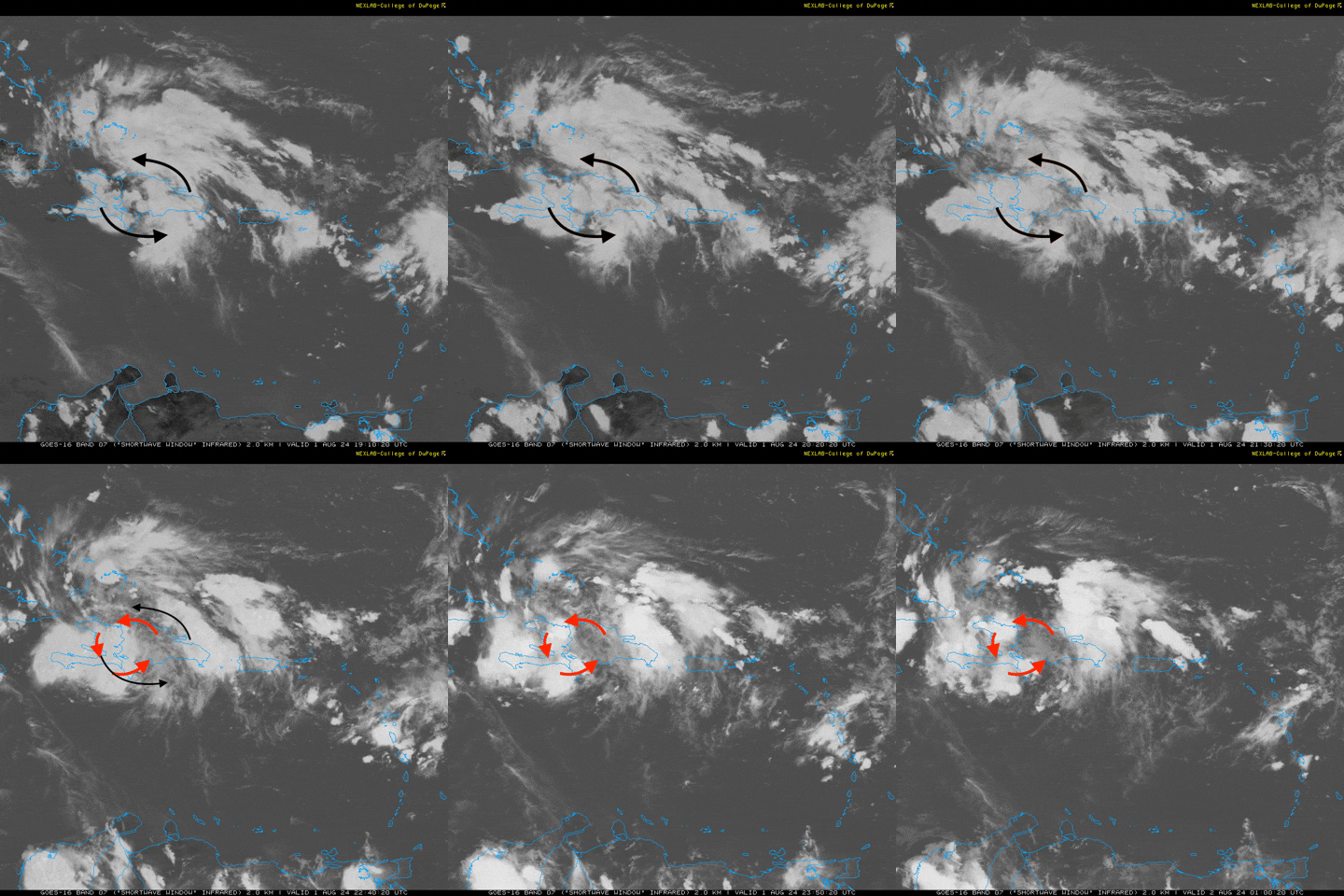
After painstakingly staring at this loop for waaaay too long, this is approximately where I think the center of vorticity might be trying to consolidate:

Image
Last edited by REDHurricane on Thu Aug 01, 2024 8:51 pm, edited 1 time in total.
3 likes   

FLLurker32
Tropical Storm
Tropical Storm
Posts: 245
Joined: Mon Aug 29, 2016 10:31 am

Re: ATL: INVEST 97L - Discussion (40/70)

#105 Postby FLLurker32 » Thu Aug 01, 2024 8:48 pm

Michele B wrote:
FLLurker32 wrote:When it comes to the panhandle and big bend areas of FL, we do not need much wind to make a very big impact right now.

We’ve had a very active rainy season and many lakes, ponds and rivers are high. They will crest in many areas with a large tropical rain event. The ground is currently saturated and many trees will easily uproot with even TD sustained winds. Most power lines are above ground in this region.

Even a TD in this region right now with enough rain will cause widespread flooding, downed trees and power outages.

The good news? My cousin leads a crew of lineman out of TX. [color=#BF0000]The call was given yesterday for crews to station in Lake City this weekend.

[/color]


Now THAT's the kind of "inside information" that is useful!

Thank you for that. It gives us a glimpse into what tptb are thinking is possible.


Absolutely. It’s also just nice for anyone potentially impacted to know that help will be here on standby ready to get right to work. If anything changes, I’ll post here to let everyone know.
1 likes   
Heather

Sciencerocks
Category 5
Category 5
Posts: 9154
Age: 39
Joined: Thu Jul 06, 2017 1:51 am

Re: ATL: INVEST 97L - Discussion (40/70)

#106 Postby Sciencerocks » Thu Aug 01, 2024 9:13 pm

Image
0 likes   

floridasun
Tropical Storm
Tropical Storm
Posts: 200
Joined: Tue Sep 14, 2021 3:59 pm

ATL: INVEST 97L - Models

#107 Postby floridasun » Thu Aug 01, 2024 9:17 pm

look like low going take shape in area ne of Cuba and nw of Haiti if look cloud you see a bit spin that area let see go into se bahama area over night or go into cuba
0 likes   

User avatar
tiger_deF
Category 1
Category 1
Posts: 468
Age: 24
Joined: Tue Sep 27, 2016 11:47 am

Re: ATL: INVEST 97L - Discussion (40/70)

#108 Postby tiger_deF » Thu Aug 01, 2024 9:31 pm

I think 97L has been favoring the southern lobes. The MLC is there, and it hasn’t produced the same level of convection as the Northern lobe since it has been over land for close to a day. The main reason the cloud formation is to the North is because of the substantial shear further south of the islands and the fact that it has been over land.
Last edited by tiger_deF on Thu Aug 01, 2024 9:59 pm, edited 1 time in total.
0 likes   

User avatar
Category5Kaiju
Category 5
Category 5
Posts: 4095
Joined: Thu Dec 24, 2020 12:45 pm
Location: Seattle

Re: ATL: INVEST 97L - Discussion (40/70)

#109 Postby Category5Kaiju » Thu Aug 01, 2024 9:33 pm

Image

Pretty favorable in the Gulf in terms of shear currently

Also, between Eta 2020, Elsa 2021, Ian, Idalia, and this storm, it really looks like recent years have been hotbeds for activity along the western part of the FL peninsula
2 likes   
Unless explicitly stated, all info in my posts is based on my own opinions and observations. Tropical storms and hurricanes can be extremely dangerous. Do not think you can beat Mother Nature. Refer to an accredited weather research agency or meteorologist if you need to make serious decisions regarding an approaching storm.

BobHarlem
Category 5
Category 5
Posts: 2098
Joined: Thu Oct 20, 2005 6:11 pm

Re: ATL: INVEST 97L - Discussion (40/70)

#110 Postby BobHarlem » Thu Aug 01, 2024 9:39 pm

At the moment it looks like the area will be more along the S. Side of Cuba, but cycnical me will wake up in the morning and watch it be on the North side. Still looking at the various satellite flavors trying to figure out what this is going to do with it since exiting Haiti and while moving into Cuba tomorrow is going to be the thing tomorrow.

Image

If I had to guess a spot, the area just south of Guantanamo Bay
Last edited by BobHarlem on Thu Aug 01, 2024 10:39 pm, edited 1 time in total.
0 likes   

Nuno
Category 2
Category 2
Posts: 597
Joined: Fri Aug 30, 2019 8:35 am
Location: Coral Gables, FL

Re: ATL: INVEST 97L - Discussion (40/70)

#111 Postby Nuno » Thu Aug 01, 2024 9:52 pm

Category5Kaiju wrote:https://i.imgur.com/E1w3gcW.png

Pretty favorable in the Gulf in terms of shear currently

Also, between Eta 2020, Elsa 2021, Ian, Idalia, and this storm, it really looks like recent years have been hotbeds for activity along the western part of the FL peninsula


Don't forget Irma
0 likes   
Andrew (1992), Irene (1999), Frances (2004), Katrina (2005), Wilma (2005), Fay (2008), Irma (2017), Eta (2020), Ian (2022)

User avatar
Hurrilurker
Category 2
Category 2
Posts: 719
Joined: Mon Jun 09, 2003 3:32 pm
Location: San Francisco, CA

Re: ATL: INVEST 97L - Discussion (40/70)

#112 Postby Hurrilurker » Thu Aug 01, 2024 10:07 pm

Certainly looks like land interaction is going to keep a lid on it for most of its run.
0 likes   

User avatar
Jr0d
S2K Supporter
S2K Supporter
Posts: 1409
Joined: Tue Aug 27, 2019 10:52 am
Location: Cayo Hueso

Re: ATL: INVEST 97L - Discussion (40/70)

#113 Postby Jr0d » Thu Aug 01, 2024 10:31 pm

floridasun wrote:
so keywest may get ts wind?


I doubt we will see much sustained winds, but likely gusty winds in squalls. It does seem like the low will start consolidating near the Keys so it might make things interesting on Saturday.

A strengthening system seems to roar more than a weakening one..I figure if it's consolidating it will be hit or miss with the more intense squalls over the Florida straits and the intense squalls will be surprisingly intense to some.b
Last edited by Jr0d on Thu Aug 01, 2024 11:12 pm, edited 1 time in total.
2 likes   

OuterBanker
S2K Supporter
S2K Supporter
Posts: 1731
Joined: Wed Feb 26, 2003 10:53 am
Location: Nags Head, NC
Contact:

Re: ATL: INVEST 97L - Discussion (40/70)

#114 Postby OuterBanker » Thu Aug 01, 2024 11:00 pm

At first this was a ms AL landfall. Then it was a flooding the state of Florida. I thought we had no concern. Now gfs has a st Pete Tampa land fall second land fall at Wilmington. CMC big bend second landfall Wilmington. Euro is kindest to all. Weak system that exits n FL GA and meanders back to cost. Icon (00z fri) agrees with gfs (odd bedfellows indeed ). Of course all will be different. Regardless I think Carolinas to Florida will get a soaking.
0 likes   

User avatar
ElectricStorm
Category 5
Category 5
Posts: 5042
Age: 24
Joined: Tue Aug 13, 2019 11:23 pm
Location: Skiatook, OK / Norman, OK

Re: ATL: INVEST 97L - Discussion (40/70)

#115 Postby ElectricStorm » Fri Aug 02, 2024 12:50 am

1. Straits of Florida and Eastern Gulf of Mexico (AL97):
A well-defined tropical wave is producing a large area of
disorganized showers and thunderstorms over Hispaniola, the
southeastern Bahamas, eastern Cuba, and the adjacent waters of the
southwestern Atlantic. The wave is expected to move near or over
Cuba throughout the day and then emerge over the Straits of Florida
tonight or Saturday. Environmental conditions are expected to be
conducive for additional development after that time, and a tropical
depression is likely to form this weekend over the Straits of
Florida or eastern Gulf of Mexico near the Florida Peninsula.
Tropical storm watches or warnings could be required for portions of
Florida later today.

Regardless of development, heavy rains could cause areas of flash
flooding across Florida, Cuba, and the Bahamas through the weekend,
and interests in these locations should continue to monitor the
progress of this system. A NOAA Hurricane Hunter aircraft is
scheduled to investigate this system later today, if necessary.
* Formation chance through 48 hours...medium...50 percent.
* Formation chance through 7 days...high...80 percent.
0 likes   
B.S Meteorology, University of Oklahoma '25

Please refer to the NHC, NWS, or SPC for official information.

User avatar
chaser1
S2K Supporter
S2K Supporter
Posts: 5464
Age: 64
Joined: Sat Oct 15, 2005 5:59 pm
Location: Longwood, Fl

Re: ATL: INVEST 97L - Discussion (40/70)

#116 Postby chaser1 » Fri Aug 02, 2024 1:18 am

Over all symmetry and organization has significantly improved during the past 12 hours. For the first time with this disturbance I am confident where the COC exists - 19.5 N 73.0 W, presently emerging off the West coast of Haiti. It will barely have more then a few hours over water before making landfall over E Cuba. It wouldn't shock me for NHC to tagging it a TD if it continues to organize.
2 likes   
Andy D

(For official information, please refer to the NHC and NWS products.)

Craters
Category 1
Category 1
Posts: 421
Joined: Sat Aug 24, 2013 2:34 pm
Location: Alvin, TX (south of Houston)

Re: ATL: INVEST 97L - Discussion (40/70)

#117 Postby Craters » Fri Aug 02, 2024 1:41 am

Jr0d wrote:
floridasun wrote:
so keywest may get ts wind?


I doubt we will see much sustained winds, but likely gusty winds in squalls. It does seem like the low will start consolidating near the Keys so it might make things interesting on Saturday.

A strengthening system seems to roar more than a weakening one..I figure if it's consolidating it will be hit or miss with the more intense squalls over the Florida straits and the intense squalls will be surprisingly intense to some.b

Jr0d — Sometimes I question your sanity but always admire your tenacity. Your living there, when more than 40% of the year you could be absolutely clobbered by Mother Nature, makes me feel like a wimp. We're about 25 miles from the Gulf, where the eyewall of "just" Caterogry 1 Beryl danced in our... well, you know..., and I'm on pins and needles from the beginning of June to the end of September, whether anything's heading this way or not. In the back of our minds, we're always expecting the least likely disaster to happen, even though we are 25 miles inland. You, on the other hand, are The Low Hanging Fruit — and by choice, you knucklehead!! God bless ya!!!
0 likes   
Nothing that I post here should ever be treated as a forecast or anything resembling one. Please check with your local NWS office or the NHC for forecasts, watches, and warnings.

caneman
Category 5
Category 5
Posts: 1447
Joined: Fri Sep 05, 2014 5:44 am
Location: Clearwater Beach, Fl

Re: ATL: INVEST 97L - Discussion (40/70)

#118 Postby caneman » Fri Aug 02, 2024 2:25 am

NHC now has development at 50/80% as of the 2 am advisory. Ahh, someone else posted it above.
0 likes   

skillz305
Category 1
Category 1
Posts: 279
Joined: Sat Sep 08, 2018 11:10 am
Location: Miami, Florida --> Vero Beach, Florida

Re: ATL: INVEST 97L - Discussion (50/80)

#119 Postby skillz305 » Fri Aug 02, 2024 4:55 am

Anybody got educated guesses about where the “center” or lack of one is at this morning? Models need to know which side of Cuba it’s on!
0 likes   
:flag:Hurricanes: Andrew 1992 - Irene 1999 - Frances 2004 - Jeanne 2004 - Katrina 2005 - Wilma 2005 - Matthew 2016 - Irma 2017 - Ian 2022 - Nicole 2022 - Milton 2024

underthwx
Category 5
Category 5
Posts: 2360
Joined: Sat Jul 30, 2011 2:14 pm
Location: Brazoria County Texas

Re: ATL: INVEST 97L - Discussion (40/70)

#120 Postby underthwx » Fri Aug 02, 2024 5:19 am

REDHurricane wrote:After painstakingly staring at this loop for waaaay too long, this is approximately where I think the center of vorticity might be trying to consolidate:

https://media1.giphy.com/media/v1.Y2lkPTc5MGI3NjExeHNpbmcweThreTRwemhmYnE5Znd3MzlhNms3OTl1OGVlM2d4YmF3diZlcD12MV9pbnRlcm5hbF9naWZfYnlfaWQmY3Q9Zw/9ZaiEam9PoPNTlvNKG/giphy.gif

Hopefully the terrain of Cuba keeps 97L in check....yall stay prepared...
0 likes   


Return to “2024”

Who is online

Users browsing this forum: No registered users and 3 guests