RevanTheJedi96 wrote:Craters wrote:RevanTheJedi96 wrote:
That Westward tug is becoming a reoccurring trend. That's what concerns me that Lee is trending more West.
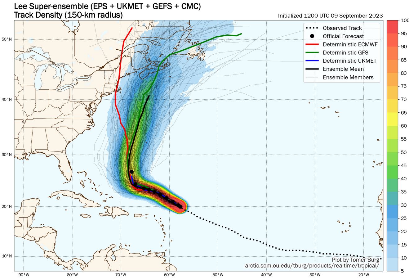
If it makes you feel any better, the ensemble means don't seem to be showing that as much as the operational trends are.
[url]https://i.ibb.co/pfBvypf/Means.jpg [/url]
We're still pretty far out, timewise, too...
It just adds more confusion to the forecast tbh
As you know, the accuracy of model results that are more than five days into the future drops rapidly, so confusion is almost always the predictable consequence. As a watcher of these things for more than 40 years in the Gulf of Mexico — and I'm sure that others might want to chime in — I'd recommend trying to relax a little bit, maybe even take a break from Storm2K (heresy, I know!), get back to normal life for a day or so, and then check in again to see what might have changed in the meantime. There's
plenty of time to adjust if you have to. Watching model results from this far out honestly will do nothing more than increase your stress and uncertainty levels. That's just the current nature of the beast. Maybe, in three or four years, the models will improve enough that they could be relied upon maybe six or seven days out. They
are improving inexorably. Until then, though, try to take what they're saying for days six onward with a block of salt.
This is probably a lousy example, but in 2005, just 2+ days out from landfall, Hurricane Rita — at the time, supposedly the most powerful storm ever recorded in the Gulf — was forcasted to put our house right in the eastern eyewall. It ended up making landfall more than 60 miles to our east, and in a considerably weakened state. Yes, the wind gusts were impressive for a storm center so far away, but that's all they were — for us, anyway.The models have improved amazingly since then, and what was two days' error back then is maybe equivalent to something like the error from eight days out now. (Don't hold me to those numbers, but I don't think they're that far off.) The point is that I was watching each and every model run for Rita so intensely for more than a week that I almost gave myself an ulcer. It just isn't worth it, because watching from this far out in time is basically like looking into fantasyland. It doesn't make sense to risk your health and/or sanity over the changes between runs of a computer model that are really just its silicon-based version of whistling in the wind.
Nothing that I post here should ever be treated as a forecast or anything resembling one. Please check with your local NWS office or the NHC for forecasts, watches, and warnings.


