
EPAC: FERNANDA - Remnants - Discussion
Moderator: S2k Moderators
-
cycloneye

- Admin

- Posts: 149813
- Age: 69
- Joined: Thu Oct 10, 2002 10:54 am
- Location: San Juan, Puerto Rico
Re: EPAC: FERNANDA - Hurricane - Discussion
Stellar.
0 likes
Visit the Caribbean-Central America Weather Thread where you can find at first post web cams,radars
and observations from Caribbean basin members Click Here
and observations from Caribbean basin members Click Here
-
cycloneye
- Admin
- Posts: 149813
- Age: 69
- Joined: Thu Oct 10, 2002 10:54 am
- Location: San Juan, Puerto Rico
Re: EPAC: FERNANDA - Hurricane - Discussion
New peak as cat 4
Hurricane Fernanda Discussion Number 6
NWS National Hurricane Center Miami FL EP072023
500 PM HST Sun Aug 13 2023
Fernanda continues to rapidly intensify this evening. Since the
prior advisory, the eye signature on visible satellite has become
much more distinct as infrared cold cloud tops between -65 to -75 C
have grown and encircled the eye. The last few microwave passes
indicate quickly improving structure, with a 2331 UTC GMI pass
showing a thick closed eyewall on the 89 and 37 GHz channels.
Satellite intensity estimates have responded by rapidly increasing,
with subjective estimates at 0000 UTC from TAFB and SAB between 77-
to 90-kt, and objective estimates covering a similar range. Given
the improvement of Fernanda's structure on satellite since that
time, the initial intensity is set near the top of those estimates
at 90 kt this advisory.
The hurricane continues to move generally westward to
west-northwestward at 280/8 kt. As mentioned previously, the
hurricane has been moving rather slowly over the last 24 hours due
to a weak mid-level ridge that has been eroded some by a cutoff low
located further north near the California coast. However, the
ridging north of Fernanda should gradually build back in as this
cutoff low retrogrades off to the northwest. The net effect of this
change should lead to the hurricane gradually accelerating over the
next several days. As Fernanda becomes more vertically shallow
towards the end of the forecast, it should also turn more westward.
The official track forecast is quite similar to the prior one, but
just a little faster, favoring a blend of the latest HCCA and TVCE
consensus aids.
Given the most recent microwave imagery showing Fernanda developing
a well-defined single closed eyewall, the hurricane seems poised to
continue rapidly intensifying. Vertical wind shear is forecast to
remain under 5 kt and sea-surface temperatures (SSTs) remaining near
29 C for the next day or so. In fact, SHIPS-RII shows a 67 percent
chance of another 30 kt increase in intensity over the next 24
hours, and the latest NHC intensity forecast now shows Fernanda
becoming a powerful Category 4 hurricane in the next day or so.
Thereafter, Fernanda will move into an increasingly dry and stable
environment, as SSTs rapidly drop off along the forecast track.
These negative factors should lead to initially gradual, and
then more rapid weakening towards the second half of the forecast
period. The latest NHC intensity forecast is above most of the
guidance over the next 24 hours, in light of its continued rapid
intensification, but falls back closer to the HCCA and IVCN
intensity aids between days 2-4. Both the GFS and ECMWF models
suggest the cyclone will become devoid of organized convection by
120 hours, and the latest intensity forecast now shows the system
becoming a remnant low by that time.
FORECAST POSITIONS AND MAX WINDS
INIT 14/0300Z 15.6N 117.2W 90 KT 105 MPH
12H 14/1200Z 15.8N 118.3W 105 KT 120 MPH
24H 15/0000Z 16.3N 119.8W 115 KT 130 MPH
36H 15/1200Z 16.9N 121.6W 105 KT 120 MPH
48H 16/0000Z 17.2N 123.8W 95 KT 110 MPH
60H 16/1200Z 17.3N 126.3W 75 KT 85 MPH
72H 17/0000Z 17.4N 129.0W 65 KT 75 MPH
96H 18/0000Z 17.7N 134.6W 40 KT 45 MPH
120H 19/0000Z 18.0N 140.5W 30 KT 35 MPH...POST-TROP/REMNT LOW
$$
Forecaster Papin
0 likes
Visit the Caribbean-Central America Weather Thread where you can find at first post web cams,radars
and observations from Caribbean basin members Click Here
and observations from Caribbean basin members Click Here
-
Yellow Evan

- Professional-Met

- Posts: 16257
- Age: 27
- Joined: Fri Jul 15, 2011 12:48 pm
- Location: Henderson, Nevada/Honolulu, HI
- Contact:
Re: EPAC: FERNANDA - Hurricane - Discussion

Eye has warmed and become well-defined. Now symmetrizing.
0 likes
-
Yellow Evan
- Professional-Met
- Posts: 16257
- Age: 27
- Joined: Fri Jul 15, 2011 12:48 pm
- Location: Henderson, Nevada/Honolulu, HI
- Contact:
Re: EPAC: FERNANDA - Hurricane - Discussion

Symmetry on visible wrecks of a high end tropical cyclone.
2 likes


Re: EPAC: FERNANDA - Hurricane - Discussion
Probably already c4, subjectively.
1 likes
The above post and any post by Ntxw is NOT an official forecast and should not be used as such. It is just the opinion of the poster and may or may not be backed by sound meteorological data. It is NOT endorsed by any professional institution including Storm2k. For official information, please refer to NWS products.
Help support Storm2K!


Re: EPAC: FERNANDA - Hurricane - Discussion
Ntxw wrote:Probably already c4, subjectively.
Completely agree. Maybe not even minimal cat 4, incredible presentation atm.
0 likes
-
cycloneye
- Admin
- Posts: 149813
- Age: 69
- Joined: Thu Oct 10, 2002 10:54 am
- Location: San Juan, Puerto Rico
Re: EPAC: FERNANDA - Hurricane - Discussion
EP, 07, 2023081406, , BEST, 0, 155N, 1174W, 105, 963, HU
0 likes
Visit the Caribbean-Central America Weather Thread where you can find at first post web cams,radars
and observations from Caribbean basin members Click Here
and observations from Caribbean basin members Click Here
-
cycloneye
- Admin
- Posts: 149813
- Age: 69
- Joined: Thu Oct 10, 2002 10:54 am
- Location: San Juan, Puerto Rico
Re: EPAC: FERNANDA - Hurricane - Discussion
Hurricane Fernanda Discussion Number 7
NWS National Hurricane Center Miami FL EP072023
1100 PM HST Sun Aug 13 2023
Fernanda continues to rapidly intensify this evening. The
well-defined eye has warmed and continues to be surrounded by a
solid core of cold cloud tops around -70C. Microwave imagery from
earlier this evening showed a thick closed eyewall and a well
defined structure. Satellite intensity estimates have continued to
increase this evening as well, with subjective estimates from TAFB
and SAB T5.5/T6.0, respectively. CIMMS ADT/AiDT objective satellite
estimates are in a similar range. Using a blend of these estimates
the initial intensity for this advisory is set at 110 kt.
The hurricane continues to move generally westward to
west-northwestward at 280/7 kt. Fernanda is being steered by a weak
mid-level ridge with a generally west to west-northwest motion
expected throughout the period. As the ridge begins to re-strengthen
in the next day or so, the hurricane will begin to move faster,
with a gradually accelerating forward speed over the next several
days. The official track forecast is quite similar to the prior
one, with just a slight adjustment northward in the short term.
Fernanda is now a major hurricane and is in an environment that will
continue to allow for further intensification. Vertical wind shear
is forecast to remain under 10 kt and with warm sea surface
temperatures. Thereafter, Fernanda will move into an increasingly
dry and stable environment, with mid-level relative humidity levels
dropping below 40 percent in about 48 hrs. This will occur at the
same time the SSTs also begin to drop off along the forecast track.
These factors should lead to initially gradual, and then more rapid
weakening. The latest NHC intensity forecast is above most of the
guidance over the next 24 hours, but is closer to the consensus aids
in days 2-4. However, there is some guidance that show an even
faster decay than what is currently forecast, with the system
becoming void of convection due to the very dry airmass.
FORECAST POSITIONS AND MAX WINDS
INIT 14/0900Z 15.6N 117.7W 110 KT 125 MPH
12H 14/1800Z 15.9N 118.8W 125 KT 145 MPH
24H 15/0600Z 16.5N 120.5W 110 KT 125 MPH
36H 15/1800Z 17.0N 122.5W 100 KT 115 MPH
48H 16/0600Z 17.3N 124.9W 85 KT 100 MPH
60H 16/1800Z 17.3N 127.5W 70 KT 80 MPH
72H 17/0600Z 17.5N 130.3W 60 KT 70 MPH
96H 18/0600Z 18.0N 136.6W 40 KT 45 MPH
120H 19/0600Z 18.5N 142.7W 30 KT 35 MPH...POST-TROP/REMNT LOW
$$
Forecaster Kelly/Brown
0 likes
Visit the Caribbean-Central America Weather Thread where you can find at first post web cams,radars
and observations from Caribbean basin members Click Here
and observations from Caribbean basin members Click Here
-
cycloneye
- Admin
- Posts: 149813
- Age: 69
- Joined: Thu Oct 10, 2002 10:54 am
- Location: San Juan, Puerto Rico
Re: EPAC: FERNANDA - Hurricane - Discussion

0 likes
Visit the Caribbean-Central America Weather Thread where you can find at first post web cams,radars
and observations from Caribbean basin members Click Here
and observations from Caribbean basin members Click Here
-
Yellow Evan
- Professional-Met
- Posts: 16257
- Age: 27
- Joined: Fri Jul 15, 2011 12:48 pm
- Location: Henderson, Nevada/Honolulu, HI
- Contact:
Re: EPAC: FERNANDA - Hurricane - Discussion


-70C cloud tops wrapping around the eye steadily while the eye remains around 18C. Easy Category 4.
1 likes

Re: EPAC: FERNANDA - Hurricane - Discussion
I think Fernanda is around 120-125 kt now. It now has a nearly complete (but not yet smooth) W ring with eye temps of >16C. This has been an incredibly impressive phase of RI that exceeded all model expectations; not even the HWRF made it this strong.
0 likes
Irene '11 Sandy '12 Hermine '16 5/15/2018 Derecho Fay '20 Isaias '20 Elsa '21 Henri '21 Ida '21
I am only a meteorology enthusiast who knows a decent amount about tropical cyclones. Look to the professional mets, the NHC, or your local weather office for the best information.
I am only a meteorology enthusiast who knows a decent amount about tropical cyclones. Look to the professional mets, the NHC, or your local weather office for the best information.
-
Extratropical94

- Professional-Met
- Posts: 3545
- Age: 31
- Joined: Wed Oct 20, 2010 6:36 am
- Location: Hamburg, Germany
- Contact:
Re: EPAC: FERNANDA - Hurricane - Discussion
Cat 4
EP, 07, 2023081412, , BEST, 0, 157N, 1181W, 115, 955, HU
0 likes
54° 11' 59'' N, 9° 9' 20'' E
Boomer Sooner!
Go Broncos! Go Cards!
Clinching counties, one at a time: https://mob-rule.com/user-gifs/USA/xtrp94.gif
- Daniel
Boomer Sooner!
Go Broncos! Go Cards!
Clinching counties, one at a time: https://mob-rule.com/user-gifs/USA/xtrp94.gif
- Daniel
-
Yellow Evan
- Professional-Met
- Posts: 16257
- Age: 27
- Joined: Fri Jul 15, 2011 12:48 pm
- Location: Henderson, Nevada/Honolulu, HI
- Contact:


-
Yellow Evan
- Professional-Met
- Posts: 16257
- Age: 27
- Joined: Fri Jul 15, 2011 12:48 pm
- Location: Henderson, Nevada/Honolulu, HI
- Contact:
Re: EPAC: FERNANDA - Hurricane - Discussion
TXPZ23 KNES 141235
TCSENP
CCA
A. 07E (FERNANDA)
B. 14/1200Z
C. 15.7N
D. 118.2W
E. ONE/GOES-W
F. T6.0/6.0
G. IR/EIR
H. REMARKS...CORRECTED FOR SATELLITE. WMG EYE IS EMBEDDED IN AND
SURROUNDED BY B RESULTING IN A DT OF 6.5 AFTER 1.0 IS ADDED FOR AN EYE
ADJUSTMENT. PT IS 5.0 AND MET IS 4.5 BASED ON RAPID DEVELOPMENT OVER
THE LAST 24 HOURS. THE FT IS BASED ON THE 6 HOUR AVERAGE DT OF 6.1,
WHICH JUSTIFIES BREAKING CONSTRAINTS.
I. ADDL POSITIONS
NIL
...TURK
0 likes
-
Kingarabian

- S2K Supporter

- Posts: 16383
- Joined: Sat Aug 08, 2009 3:06 am
- Location: Honolulu, Hawaii
Re: EPAC: FERNANDA - Hurricane - Discussion
Beautiful system, easily 120kts. May peak soon though.
0 likes
RIP Kobe Bryant
-
Sciencerocks
- Category 5

- Posts: 10194
- Age: 40
- Joined: Thu Jul 06, 2017 1:51 am

-
cycloneye
- Admin
- Posts: 149813
- Age: 69
- Joined: Thu Oct 10, 2002 10:54 am
- Location: San Juan, Puerto Rico
Re: EPAC: FERNANDA - Hurricane - Discussion
0 likes
Visit the Caribbean-Central America Weather Thread where you can find at first post web cams,radars
and observations from Caribbean basin members Click Here
and observations from Caribbean basin members Click Here
-
cycloneye
- Admin
- Posts: 149813
- Age: 69
- Joined: Thu Oct 10, 2002 10:54 am
- Location: San Juan, Puerto Rico
Re: EPAC: FERNANDA - Hurricane - Discussion
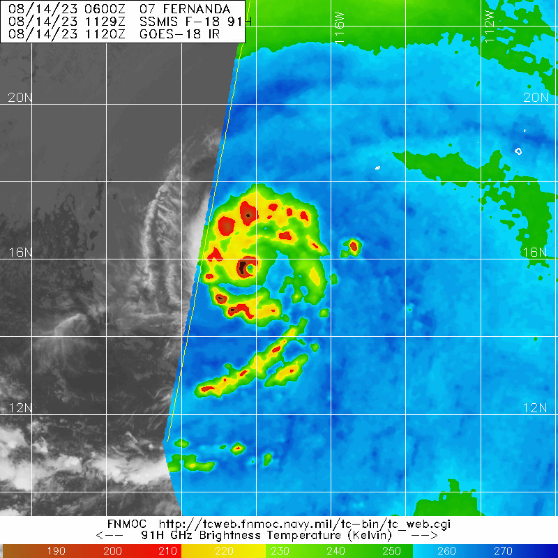
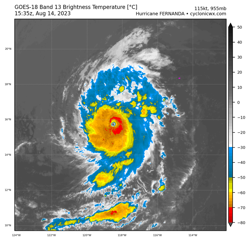
Hurricane Fernanda Discussion Number 8
NWS National Hurricane Center Miami FL EP072023
500 AM HST Mon Aug 14 2023
Fernanda has continued to intensify this morning. The 10 nmi-
diameter eye is very well defined and is surrounded by a ring of
-70 deg C or colder convective cloud tops. The hurricane's
upper-level outflow pattern remains quite symmetric. Dvorak data
T-numbers for the system are now around 6.0 which supports an
intensity of 115 kt, i.e. category 4 intensity. This is also in
good agreement with objective ADT estimates from UW-CIMSS.
A westward to west-northwestward track continues with an initial
motion estimate of about 280/7 kt. There are no significant
changes to the track forecast reasoning from the previous
advisory. A weak mid-tropospheric ridge to the north of
Fernanda should gradually strengthen over the next several days.
This should result in a continued west-northwestward or slightly
north of westward movement with some increase of forward speed over
the next several days. Late in the forecast period, the weakening
cyclone should move mostly westward, following the low-level
environmental flow. The official track forecast is close to both
the simple and corrected dynamical model consensus guidance.
The hurricane should traverse SSTs of 28-29 deg C today while
remaining in a low-vertical wind shear environment. Therefore some
additional strengthening will probably occur today. By early
tomorrow and thereafter, Fernanda should begin to encounter the
drier low- to mid-level air mass that is seen in the GOES-18
lower-level water vapor imagery not far to the west-northwest of the
tropical cyclone. This, along with cooler ocean waters, should
result in steady weakening of the system over the next 2-5 days.
The official intensity forecast calls for Fernanda to degenerate
into a post-tropical cyclone at 96 h. However, based on the
latest simulated satellite imagery from the global models, a faster
rate of weakening is certainly possible.
FORECAST POSITIONS AND MAX WINDS
INIT 14/1500Z 15.8N 118.5W 115 KT 130 MPH
12H 15/0000Z 16.3N 119.6W 125 KT 145 MPH
24H 15/1200Z 17.0N 121.4W 105 KT 120 MPH
36H 16/0000Z 17.4N 123.6W 90 KT 105 MPH
48H 16/1200Z 17.6N 126.2W 75 KT 85 MPH
60H 17/0000Z 17.8N 128.9W 60 KT 70 MPH
72H 17/1200Z 18.0N 131.8W 45 KT 50 MPH
96H 18/1200Z 18.3N 137.9W 35 KT 40 MPH...POST-TROPICAL
120H 19/1200Z 18.5N 144.0W 25 KT 30 MPH...POST-TROP/REMNT LOW
$$
Forecaster Pasch
0 likes
Visit the Caribbean-Central America Weather Thread where you can find at first post web cams,radars
and observations from Caribbean basin members Click Here
and observations from Caribbean basin members Click Here
Re: EPAC: FERNANDA - Hurricane - Discussion
Definitely beat expectations. Another gorgeous system.

0 likes
The above post and any post by Ntxw is NOT an official forecast and should not be used as such. It is just the opinion of the poster and may or may not be backed by sound meteorological data. It is NOT endorsed by any professional institution including Storm2k. For official information, please refer to NWS products.
Help support Storm2K!
Help support Storm2K!
-
Kingarabian
- S2K Supporter
- Posts: 16383
- Joined: Sat Aug 08, 2009 3:06 am
- Location: Honolulu, Hawaii
Re: EPAC: FERNANDA - Hurricane - Discussion
Was dealing with some dry air intrusion earlier.
1 likes
RIP Kobe Bryant
Who is online
Users browsing this forum: No registered users and 36 guests