EPAC: OTIS - Aftermath - Discussion
Moderator: S2k Moderators
-
xtyphooncyclonex

- Category 5

- Posts: 3899
- Age: 24
- Joined: Sat Dec 08, 2012 9:07 am
- Location: Cebu City
- Contact:
Re: EPAC: OTIS - Hurricane - Discussion: 4 PM CDT=125 mph (CAT 4)
From a supposed TS to possible high-end Category 4 landfall? What did I just wake up to?
7 likes
REMINDER: My opinions that I, or any other NON Pro-Met in this forum, are unofficial. Please do not take my opinions as an official forecast and warning. I am NOT a meteorologist. Following my forecasts blindly may lead to false alarm, danger and risk if official forecasts from agencies are ignored.
-
cheezyWXguy

- Category 5
- Posts: 6282
- Joined: Mon Feb 13, 2006 12:29 am
- Location: Dallas, TX
Re: EPAC: OTIS - Hurricane - Discussion: 4 PM CDT=125 mph (CAT 4)
Yellow Evan wrote:Looks kinda shear on IR with an eye struggling to clear out even if globals are diagnosing only about 10 knots of shear.
If shear was affecting it before, it doesn’t seem to be now. Eye is warming pretty quickly now and given how cold its cdo is, it doesn’t look like it’s leveling off anytime soon. This is looking bad
0 likes
-
Astromanía
- Category 2

- Posts: 798
- Age: 27
- Joined: Sat Aug 25, 2018 10:34 pm
- Location: Monterrey, N.L, México
Re: EPAC: OTIS - Hurricane - Discussion: 4 PM CDT=125 mph (Cat 4)
130 kt is the record for wind speed at landfall in EPAC, Otis is currently at 110 kt and still strenghtening
0 likes
-
Sciencerocks
- Category 5
- Posts: 10193
- Age: 40
- Joined: Thu Jul 06, 2017 1:51 am

-
cycloneye

- Admin

- Posts: 149719
- Age: 69
- Joined: Thu Oct 10, 2002 10:54 am
- Location: San Juan, Puerto Rico
Re: EPAC: OTIS - Hurricane - Discussion: 4 PM CDT=125 mph (Cat 4)
There will not be another mission by recon tonight, so NHC will rely on a lucky ASCAT that hits it partial or full.
0 likes
Visit the Caribbean-Central America Weather Thread where you can find at first post web cams,radars
and observations from Caribbean basin members Click Here
and observations from Caribbean basin members Click Here
-
Hypercane_Kyle

- Category 5
- Posts: 3465
- Joined: Sat Mar 07, 2015 7:58 pm
- Location: Cape Canaveral, FL
Re: EPAC: OTIS - Hurricane - Discussion
Eye is rapidly clearing... Otis has a real solid chance of being close to 125 knots at landfall.
0 likes
My posts are my own personal opinion, defer to the National Hurricane Center (NHC) and other NOAA products for decision making during hurricane season.
-
cycloneye
- Admin
- Posts: 149719
- Age: 69
- Joined: Thu Oct 10, 2002 10:54 am
- Location: San Juan, Puerto Rico
Re: EPAC: OTIS - Hurricane - Discussion
Hurricane Otis Special Discussion Number 11
NWS National Hurricane Center Miami FL EP182023
700 PM CDT Tue Oct 24 2023
This special advisory is being issued to update the current and
forecast intensity of Otis. Satellite images show that the very
rapid intensification observed earlier today has continued, and the
latest data support an initial intensity of 125 kt. The intensity
forecast peak is updated to 140 kt, category 5 strength, since the
environment isn't forecast to change much before landfall, and there
are no signs of this explosive intensification stopping. This is
an extremely dangerous situation, and all preparations for Otis
should be rushed to completion.
There are no changes to the track or wind radii forecast on this
advisory, and this special advisory is being issued in lieu of the
Intermediate Advisory.
Key Messages:
1. Otis is forecast to be a potentially catastrophic Category 5
hurricane when it reaches the southern coast of Mexico late tonight
or early Wednesday, and preparations to protect life and property
should be rushed to completion.
2. A potentially catastrophic storm surge is expected to produce
life-threatening coastal flooding near and to the east of where the
center makes landfall. Near the coast, the surge will be
accompanied by large and destructive waves.
3. Heavy rains from Otis will continue to impact areas of southwest
Mexico this week. This rainfall will produce flash and urban
flooding, along with mudslides in areas of higher terrain.
FORECAST POSITIONS AND MAX WINDS
INIT 25/0000Z 15.7N 99.6W 125 KT 145 MPH
12H 25/0600Z 16.3N 100.0W 140 KT 160 MPH
24H 25/1800Z 17.5N 100.8W 90 KT 105 MPH...INLAND
36H 26/0600Z 18.1N 101.5W 50 KT 60 MPH...INLAND
48H 26/1800Z 18.4N 102.1W 30 KT 35 MPH...INLAND
60H 27/0600Z...DISSIPATED
$$
Forecaster Blake
3 likes
Visit the Caribbean-Central America Weather Thread where you can find at first post web cams,radars
and observations from Caribbean basin members Click Here
and observations from Caribbean basin members Click Here
-
Yellow Evan

- Professional-Met

- Posts: 16257
- Age: 27
- Joined: Fri Jul 15, 2011 12:48 pm
- Location: Henderson, Nevada/Honolulu, HI
- Contact:
Re: EPAC: OTIS - Hurricane - Discussion

Category 5 inbound. Likely around 120-130 knots right now with eye becoming more defined and warming and the convection from the west earlier has wrapped around.
3 likes
-
ElectricStorm

- Category 5
- Posts: 5155
- Age: 25
- Joined: Tue Aug 13, 2019 11:23 pm
- Location: Norman, OK
Re: EPAC: OTIS - Hurricane - Discussion: Special Advisory=145 mph / Could be cat 5 at landfall
I agree with NHC, this is going to break the record for strongest EPAC landfall. Unreal. I really hope everyone is prepared
1 likes
B.S Meteorology, University of Oklahoma '25
Please refer to the NHC, NWS, or SPC for official information.
Please refer to the NHC, NWS, or SPC for official information.
-
cycloneye
- Admin
- Posts: 149719
- Age: 69
- Joined: Thu Oct 10, 2002 10:54 am
- Location: San Juan, Puerto Rico
Re: EPAC: OTIS - Hurricane - Discussion: Special Advisory=145 mph / Could be cat 5 at landfall

3 likes
Visit the Caribbean-Central America Weather Thread where you can find at first post web cams,radars
and observations from Caribbean basin members Click Here
and observations from Caribbean basin members Click Here

Re: EPAC: OTIS - Hurricane - Discussion: Special Advisory=145 mph / Will be cat 5 at landfall
Remember when Otis was only supposed to peak at 40-50 kt?
I can’t really recall any storm like this with such a low early forecast, only for it to explode out of nowhere this close to landfall. I don’t recall many or any model runs showing a major at landfall. Now it might be a 5. Insane.
I can’t really recall any storm like this with such a low early forecast, only for it to explode out of nowhere this close to landfall. I don’t recall many or any model runs showing a major at landfall. Now it might be a 5. Insane.
4 likes
Irene '11 Sandy '12 Hermine '16 5/15/2018 Derecho Fay '20 Isaias '20 Elsa '21 Henri '21 Ida '21
I am only a meteorology enthusiast who knows a decent amount about tropical cyclones. Look to the professional mets, the NHC, or your local weather office for the best information.
I am only a meteorology enthusiast who knows a decent amount about tropical cyclones. Look to the professional mets, the NHC, or your local weather office for the best information.
-
galaxy401

- Category 5
- Posts: 2446
- Age: 30
- Joined: Sat Aug 25, 2012 9:04 pm
- Location: Casa Grande, Arizona
Re: EPAC: OTIS - Hurricane - Discussion: Special Advisory=145 mph / Will be cat 5 at landfall
Otis will be the 5th storm to hit Mexico this season. I think it's hitting close to the same area as Max last week. No one there expected this.
1 likes
Got my eyes on moving right into Hurricane Alley: Florida.


-
AnnularCane

- S2K Supporter

- Posts: 2964
- Joined: Thu Jun 08, 2006 9:18 am
- Location: Wytheville, VA
Re: EPAC: OTIS - Hurricane - Discussion: Special Advisory=145 mph / Will be cat 5 at landfall
aspen wrote:Remember when Otis was only supposed to peak at 40-50 kt?
I can’t really recall any storm like this with such a low early forecast, only for it to explode out of nowhere this close to landfall. I don’t recall many or any model runs showing a major at landfall. Now it might be a 5. Insane.
Joaquin wasn't supposed to become more than a TD.
2 likes
"But it never rained rain. It never snowed snow. And it never blew just wind. It rained things like soup and juice. It snowed mashed potatoes and green peas. And sometimes the wind blew in storms of hamburgers." -- Judi Barrett, Cloudy with a Chance of Meatballs
-
xtyphooncyclonex
- Category 5
- Posts: 3899
- Age: 24
- Joined: Sat Dec 08, 2012 9:07 am
- Location: Cebu City
- Contact:
Re: EPAC: OTIS - Hurricane - Discussion: Special Advisory=145 mph / Will be cat 5 at landfall
1 likes
REMINDER: My opinions that I, or any other NON Pro-Met in this forum, are unofficial. Please do not take my opinions as an official forecast and warning. I am NOT a meteorologist. Following my forecasts blindly may lead to false alarm, danger and risk if official forecasts from agencies are ignored.


Re: EPAC: OTIS - Hurricane - Discussion: Special Advisory=145 mph / Will be cat 5 at landfall
Plotting the last three hours of motion from NHC, eye is heading for Acapulco. Hopefully, the mid and upper air data in that area are very accurate, as forecast motion is dependent on that; taking the center west of the only big city around. A 5% right of forecast path for a few hours, or one major wobble east of forecast track could put a category 5 into a major resort area; with only a few hours to prepare; much less get out.
Yikes!
Yikes!
2 likes
List of 79 tropical cyclones intercepted by Richard Horodner:
http://www.canebeard.com/page/page/572246.htm
former storm2k screenname Beoumont 2009+
http://www.canebeard.com/page/page/572246.htm
former storm2k screenname Beoumont 2009+
-
xtyphooncyclonex
- Category 5
- Posts: 3899
- Age: 24
- Joined: Sat Dec 08, 2012 9:07 am
- Location: Cebu City
- Contact:
Re: EPAC: OTIS - Hurricane - Discussion: Special Advisory=145 mph / Will be cat 5 at landfall
3 likes
REMINDER: My opinions that I, or any other NON Pro-Met in this forum, are unofficial. Please do not take my opinions as an official forecast and warning. I am NOT a meteorologist. Following my forecasts blindly may lead to false alarm, danger and risk if official forecasts from agencies are ignored.
-
DorkyMcDorkface

- Category 5
- Posts: 1043
- Age: 28
- Joined: Mon Sep 30, 2019 1:32 pm
- Location: Mid-Atlantic
Re: EPAC: OTIS - Hurricane - Discussion: Special Advisory=145 mph / Could be cat 5 at landfall
cycloneye wrote:https://i.imgur.com/4Q8nLrH.gif
Wow, both the CDO axissymmetrized and eye warmed in a hurry, nothing to really inhibit it either from now until landfall. I think this is gonna catch a lot of people off guard in Guerrero...
0 likes
Please note the thoughts expressed by this account are solely those of the user and are from a hobbyist perspective. For more comprehensive analysis, consult an actual professional meteorologist or meteorological agency.
Floyd 1999 | Isabel 2003 | Hanna 2008 | Irene 2011 | Sandy 2012 | Isaias 2020

Re: EPAC: OTIS - Hurricane - Discussion: Special Advisory=145 mph / Will be cat 5 at landfall
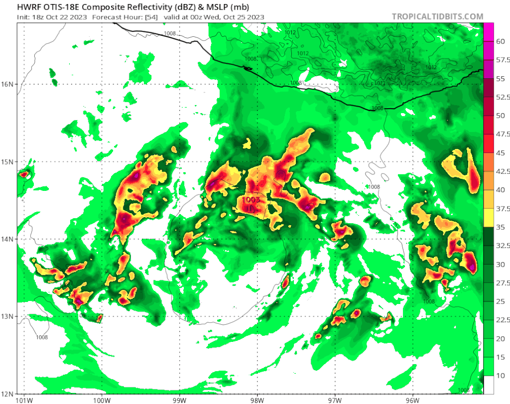
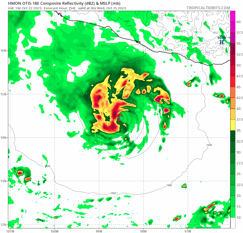
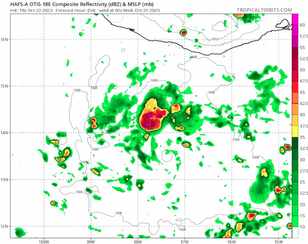
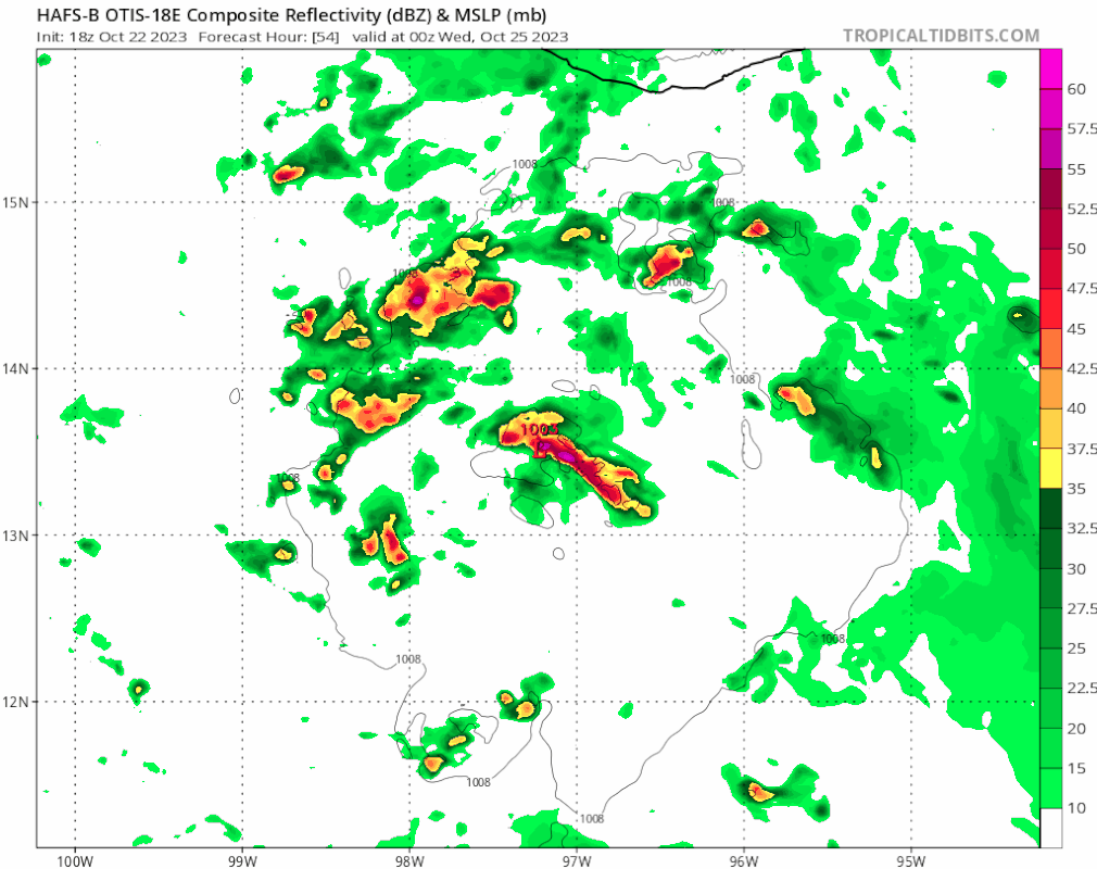
To show how absurd this RI is, here are model trends within the last 2 days - generally regarded as a reliable range for models. Keep in mind, hurricane models are frequently criticized for being too aggressive.
The forecasts are for 0z Oct 25. NHC's pressure estimate at this time is 941 mb.
HWRF:
HMON:
HAFS-A:
HAFS-B:
GFS:
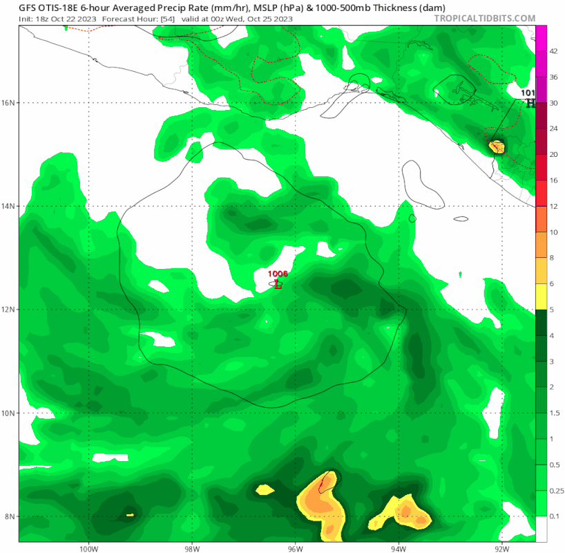
ECMWF:
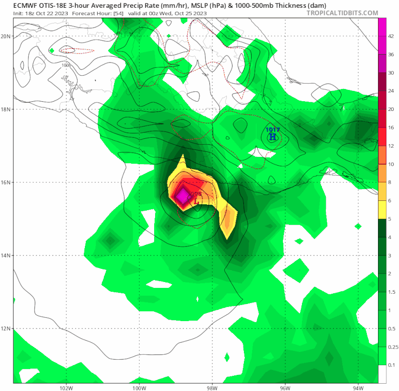
None of the hurricane models shows a major hurricane until the last 1-2 frames (6-12 hours ago). Euro still insists that it will be a TS.
The forecasts are for 0z Oct 25. NHC's pressure estimate at this time is 941 mb.
HWRF:
HMON:
HAFS-A:
HAFS-B:
GFS:
ECMWF:
None of the hurricane models shows a major hurricane until the last 1-2 frames (6-12 hours ago). Euro still insists that it will be a TS.
10 likes
TC naming lists: retirements and intensity
Most aggressive Advisory #1's in North Atlantic (cr. kevin for starting the list)
Most aggressive Advisory #1's in North Atlantic (cr. kevin for starting the list)
-
Iceresistance

- Category 5
- Posts: 9607
- Age: 22
- Joined: Sat Oct 10, 2020 9:45 am
- Location: Tecumseh, OK/Norman, OK
Re: EPAC: OTIS - Hurricane - Discussion: Special Advisory=145 mph / Will be cat 5 at landfall
This is one of the scariest NHC Special Advisories I have seen...
This special advisory is being issued to update the current and
forecast intensity of Otis. Satellite images show that the very
rapid intensification observed earlier today has continued, and the
latest data support an initial intensity of 125 kt. The intensity
forecast peak is updated to 140 kt, category 5 strength, since the
environment isn't forecast to change much before landfall, and there
are no signs of this explosive intensification stopping. This is
an extremely dangerous situation, and all preparations for Otis
should be rushed to completion.
7 likes
Bill 2015 & Beta 2020
Winter 2020-2021
All observations are in Tecumseh, OK unless otherwise noted.
Winter posts are focused mainly for Oklahoma & Texas.
Take any of my forecasts with a grain of salt, refer to the NWS, SPC, and NHC for official information
Never say Never with weather! Because ANYTHING is possible!
Winter 2020-2021
All observations are in Tecumseh, OK unless otherwise noted.
Winter posts are focused mainly for Oklahoma & Texas.
Take any of my forecasts with a grain of salt, refer to the NWS, SPC, and NHC for official information
Never say Never with weather! Because ANYTHING is possible!
Who is online
Users browsing this forum: No registered users and 50 guests