EP, 15, 2023100618, , BEST, 0, 163N, 1110W, 60, 991, TS
EPAC: LIDIA - Remnants - Discussion
Moderator: S2k Moderators
-
cycloneye

- Admin

- Posts: 149836
- Age: 69
- Joined: Thu Oct 10, 2002 10:54 am
- Location: San Juan, Puerto Rico
Re: EPAC: LIDIA - Tropical Storm - Discussion
No hurricane yet.
0 likes
Visit the Caribbean-Central America Weather Thread where you can find at first post web cams,radars
and observations from Caribbean basin members Click Here
and observations from Caribbean basin members Click Here

Re: EPAC: LIDIA - Tropical Storm - Discussion
cycloneye wrote:No hurricane yet.EP, 15, 2023100618, , BEST, 0, 163N, 1110W, 60, 991, TS
Has there been a newly formed hurricane with an exposed LLC before?
0 likes
TC naming lists: retirements and intensity
Most aggressive Advisory #1's in North Atlantic (cr. kevin for starting the list)
Most aggressive Advisory #1's in North Atlantic (cr. kevin for starting the list)
-
Sciencerocks
- Category 5

- Posts: 10194
- Age: 40
- Joined: Thu Jul 06, 2017 1:51 am

-
Hurricane2022

- Category 5
- Posts: 2096
- Joined: Tue Aug 23, 2022 11:38 pm
- Location: Araçatuba, Brazil
Re: EPAC: LIDIA - Tropical Storm - Discussion
Teban54 wrote:cycloneye wrote:No hurricane yet.EP, 15, 2023100618, , BEST, 0, 163N, 1110W, 60, 991, TS
Has there been a newly formed hurricane with an exposed LLC before?
Barry 2019?
1 likes
Sorry for the bad English sometimes...!
For reliable and detailed information for any meteorological phenomenon, please consult the National Hurricane Center, Joint Typhoon Warning Center , or your local Meteo Center.
--------
ECCE OMNIA NOVA FACIAM (Ap 21,5).
For reliable and detailed information for any meteorological phenomenon, please consult the National Hurricane Center, Joint Typhoon Warning Center , or your local Meteo Center.
--------
ECCE OMNIA NOVA FACIAM (Ap 21,5).
-
cycloneye
- Admin
- Posts: 149836
- Age: 69
- Joined: Thu Oct 10, 2002 10:54 am
- Location: San Juan, Puerto Rico
Re: EPAC: LIDIA - Tropical Storm - Discussion
Tropical Storm Lidia Discussion Number 15
NWS National Hurricane Center Miami FL EP152023
300 PM MDT Fri Oct 06 2023
Lidia remains sheared, with its low-level center nearly exposed in
recent visible satellite imagery. Confidence in the center position
of Lidia is therefore much higher than it was six hours ago. Recent
Dvorak intensity fixes still appear to be inflated relative to
Lidia's observed structure. Thus, the intensity estimate is again
based heavily on objective techniques that incorporate microwave
data, such as the UW-CIMSS DMINT, which still support an intensity
near 60 kt.
For the next 2-3 days, confidence in the NHC track and intensity
forecasts is fairly high. Lidia is forecast to continue moving
generally westward to west-northwestward today, and then gradually
turn northward through the weekend. The tropical storm will likely
remain sheared during this time, which should result in only small
fluctuations in intensity. Lidia could still become a hurricane
tonight or over the weekend.
Beyond about 72 h, the forecast uncertainty increases substantially.
The tropical storm is forecast to interact with a mid-latitude
short-wave trough, which should cause it to accelerate
northeastward. The trough interaction will also cause a change in
the environmental mid- to upper-level wind pattern, resulting in a
southwesterly shear vector and an increase in upper-level difluence.
Some models, including both HAFS-A and HAFS-B, indicate that Lidia
could begin to strengthen at this time, while others keep it
steady-state and strongly sheared. There is also uncertainty with
the forward speed of Lidia. For instance, the GFS shows a much
faster forward speed than most other models. Run-to-run consistency
of the models in the 4-5 day time frame has been poor today, so only
very small adjustments were made to the NHC forecast at this time.
Larger changes may be required over the weekend as the forecast
becomes clearer.
FORECAST POSITIONS AND MAX WINDS
INIT 06/2100Z 16.4N 111.2W 60 KT 70 MPH
12H 07/0600Z 16.4N 112.0W 65 KT 75 MPH
24H 07/1800Z 16.6N 112.8W 65 KT 75 MPH
36H 08/0600Z 17.0N 113.4W 65 KT 75 MPH
48H 08/1800Z 17.6N 113.6W 60 KT 70 MPH
60H 09/0600Z 18.2N 113.4W 60 KT 70 MPH
72H 09/1800Z 18.7N 112.7W 60 KT 70 MPH
96H 10/1800Z 19.8N 109.8W 60 KT 70 MPH
120H 11/1800Z 21.5N 107.5W 55 KT 65 MPH
$$
Forecaster D. Zelinsky/Delgado
0 likes
Visit the Caribbean-Central America Weather Thread where you can find at first post web cams,radars
and observations from Caribbean basin members Click Here
and observations from Caribbean basin members Click Here
-
cycloneye
- Admin
- Posts: 149836
- Age: 69
- Joined: Thu Oct 10, 2002 10:54 am
- Location: San Juan, Puerto Rico
Re: EPAC: LIDIA - Tropical Storm - Discussion
0 likes
Visit the Caribbean-Central America Weather Thread where you can find at first post web cams,radars
and observations from Caribbean basin members Click Here
and observations from Caribbean basin members Click Here
-
Sciencerocks
- Category 5
- Posts: 10194
- Age: 40
- Joined: Thu Jul 06, 2017 1:51 am

-
Kingarabian

- S2K Supporter

- Posts: 16383
- Joined: Sat Aug 08, 2009 3:06 am
- Location: Honolulu, Hawaii
Re: EPAC: LIDIA - Tropical Storm - Discussion
60kts is likely too generous here.
0 likes
RIP Kobe Bryant
-
cycloneye
- Admin
- Posts: 149836
- Age: 69
- Joined: Thu Oct 10, 2002 10:54 am
- Location: San Juan, Puerto Rico
Re: EPAC: LIDIA - Tropical Storm - Discussion
Tropical Storm Lidia Discussion Number 16
NWS National Hurricane Center Miami FL EP152023
900 PM MDT Fri Oct 06 2023
Moderate easterly deep-layer shear continues over Lidia this
evening. Earlier visible satellite images along with AMSR2 and SSMIS
passive microwave data indicate the low-level center lies near the
northeastern edge of a large convective mass. The cyclone continues
to produce very deep convection, with infrared cloud tops as cold as
-85 deg C. But, the tilted vertical structure signifies that Lidia
has likely not strengthened, and the initial intensity is held at 60
kt. This is once again in best agreement with the UW-CIMSS SATCON,
D-PRINT, and D-MINT estimates. The ASCAT-B and -C overpasses
expected over Lidia later tonight should help to better assess the
low-level structure and refine the wind radii values.
Lidia is moving slowly westward at 275/5 kt. In the near term,
models are in good agreement that the storm will gradually turn
northwestward and northward during the next couple of days. By early
next week, a developing shortwave trough over the eastern Pacific is
forecast to cause Lidia to accelerate northeastward and move toward
the southwestern or west-central coast of Mexico. There is increased
spread in the guidance beyond 72 h, particularly in the along-track
direction. The NHC track forecast has been shifted slightly to the
right of the previous prediction, bringing it closer to the latest
consensus aids. The day 5 forecast position is just inland over
western Mexico, but note uncertainty is high as the GFS and ECMWF
are over 24 h apart in terms of when Lidia might reach the coast.
Although Lidia is currently moving over very warm SSTs, the easterly
shear is forecast to persist over the next couple of days. Thus,
only small intensity fluctuations are forecast through the weekend,
and Lidia could hover near or just below hurricane intensity during
this period. The global and regional models suggest there is a brief
window where Lidia could move under an upper-level ridge in about 3
days, providing a brief respite from the shear and allowing the
cyclone to become better organized. There is also some potential for
positive trough interaction thereafter, despite the increased
southwesterly shear forecast at 96-120 h. The spread in the
intensity guidance grows substantially beyond day 3. The HAFS-A and
-B models show Lidia peaking as a major hurricane, while the GFS
shows a hurricane and other global and regional models keep the
system a tropical storm. Overall, there is enough model evidence to
warrant showing slight strengthening later in the period, but the
longer-range intensity forecast is highly uncertain and future
adjustments may be required.
FORECAST POSITIONS AND MAX WINDS
INIT 07/0300Z 16.4N 111.6W 60 KT 70 MPH
12H 07/1200Z 16.5N 112.3W 65 KT 75 MPH
24H 08/0000Z 16.8N 113.0W 65 KT 75 MPH
36H 08/1200Z 17.3N 113.3W 60 KT 70 MPH
48H 09/0000Z 17.9N 113.2W 60 KT 70 MPH
60H 09/1200Z 18.5N 112.6W 60 KT 70 MPH
72H 10/0000Z 19.0N 111.5W 65 KT 75 MPH
96H 11/0000Z 20.5N 108.5W 60 KT 70 MPH
120H 12/0000Z 22.5N 105.5W 55 KT 65 MPH...INLAND
$$
Forecaster Reinhart
0 likes
Visit the Caribbean-Central America Weather Thread where you can find at first post web cams,radars
and observations from Caribbean basin members Click Here
and observations from Caribbean basin members Click Here
-
cycloneye
- Admin
- Posts: 149836
- Age: 69
- Joined: Thu Oct 10, 2002 10:54 am
- Location: San Juan, Puerto Rico
Re: EPAC: LIDIA - Tropical Storm - Discussion
Tropical Storm Lidia Discussion Number 17
NWS National Hurricane Center Miami FL EP152023
300 AM MDT Sat Oct 07 2023
Scatterometer and microwave data indicate that Lidia remains a
sheared tropical storm. The center of the storm is on the eastern
edge of an intense convective cloud shield, much as it has been
for days now. The initial intensity is reduced to 55 kt on this
advisory, representing a compromise between coarse scatterometer
data indicating 40-45 kt, and much higher satellite estimates.
The center of Lidia has either moved or re-formed a bit to the
south, and it seems to be moving westward at about 4 kt. Lidia
should slowly turn to the northwest and north during the next day
or two while ridging weakens nearby. After that time, a trough
diving in from the eastern Pacific and northwestern Mexico should
force the storm northeastward with increasing forward speed, in the
general direction of west-central Mexico. There is still a very
large difference in the forward speeds of the guidance, with the
GFS-based guidance much faster than the rest of the suite. Overall,
most of the models are leaning toward a faster solution, and the
next NHC track forecast is adjusted northeastward from the last
one, though still well behind the GFS model.
Persistent easterly shear is not forecast to abate during the next
couple of days, thus little change in Lidia's intensity is
anticipated during that time. This shear could relax while the
cyclone approaches Mexico, and gradual strengthening is shown then
while Lidia moves over very warm waters, though some of the
guidance increase the shear again before landfall. There continues
to be a large spread in the intensity models, from major hurricane
strength to a tropical storm near landfall, resulting from the high
track and environmental uncertainty. The new forecast is reduced
during the short term, consistent with the model trend, and is about
the same as the last one at longer range. This is considered a
low-confidence prediction due to the reliance on the track forecast
and the huge model spread.
FORECAST POSITIONS AND MAX WINDS
INIT 07/0900Z 16.0N 111.9W 55 KT 65 MPH
12H 07/1800Z 16.1N 112.4W 55 KT 65 MPH
24H 08/0600Z 16.6N 112.8W 55 KT 65 MPH
36H 08/1800Z 17.3N 112.8W 55 KT 65 MPH
48H 09/0600Z 17.9N 112.5W 55 KT 65 MPH
60H 09/1800Z 18.5N 111.6W 60 KT 70 MPH
72H 10/0600Z 19.2N 110.0W 65 KT 75 MPH
96H 11/0600Z 21.0N 106.7W 60 KT 70 MPH
120H 12/0600Z 24.0N 102.0W 20 KT 25 MPH...POST-TROP/REMNT LOW
$$
Forecaster Blake
0 likes
Visit the Caribbean-Central America Weather Thread where you can find at first post web cams,radars
and observations from Caribbean basin members Click Here
and observations from Caribbean basin members Click Here
-
Sciencerocks
- Category 5
- Posts: 10194
- Age: 40
- Joined: Thu Jul 06, 2017 1:51 am

-
cycloneye
- Admin
- Posts: 149836
- Age: 69
- Joined: Thu Oct 10, 2002 10:54 am
- Location: San Juan, Puerto Rico
Re: EPAC: LIDIA - Tropical Storm - Discussion
Tropical Storm Lidia Discussion Number 18
NWS National Hurricane Center Miami FL EP152023
900 AM MDT Sat Oct 07 2023
Infrared satellite imagery this morning indicates that easterly
shear continues to impact Lidia. A recent AMSR-2 microwave pass
showed the low-level center embedded along the eastern edge of the
most intense deep convection. Based on a blend of subjective and
objective intensity estimates from TAFB/SAB and UW-CIMSS,
respectively, the intensity is held at 55 kt for this advisory.
Lidia has begun its turn toward the northwest, and the storm is
currently moving west-northwestward at approximately 4 kt. A slow
turn to the north is expected during the next day or so, after which
time it is expected to begin interacting with an approaching trough
from the north. This interaction will result in an acceleration
early next week toward the northeast and in the general direction
of west-central Mexico. While some uncertainty exists in the
forward speed forecast, the current forecast is very similar to the
prior forecast and lies between the TVCN and HCCA consensus aids.
Easterly shear is forecast to remain strong and inhibit significant
intensification through the weekend. During this time the NHC
intensity forecast shows little change. However, early next week
the shear is expected to briefly relax as the storm begins to
accelerate northeastward over warm sea-surface temperatures. During
this time, Lidia is forecast to intensify to hurricane strength. Of
note, southwesterly shear is expected to increase as the storm
approaches Mexico, and the spread is quite large among the intensity
guidance aids. The ECMWF and GFS global models both depict central
pressures that suggest Lidia could maintain hurricane intensity,
while other reliable statistical models and consensus aids are not
as aggressive. The NHC forecast is similar to the prior forecast and
near the center of the guidance envelope. Confidence in the
intensity forecast is low considering the wide range of solutions,
but interests in west-central Mexico should remain attentive to
forecast updates in the coming days.
FORECAST POSITIONS AND MAX WINDS
INIT 07/1500Z 16.2N 112.2W 55 KT 65 MPH
12H 08/0000Z 16.5N 112.6W 55 KT 65 MPH
24H 08/1200Z 17.1N 112.8W 55 KT 65 MPH
36H 09/0000Z 17.9N 112.7W 55 KT 65 MPH
48H 09/1200Z 18.6N 112.0W 55 KT 65 MPH
60H 10/0000Z 19.1N 110.9W 60 KT 70 MPH
72H 10/1200Z 19.8N 109.0W 65 KT 75 MPH
96H 11/1200Z 21.6N 105.4W 65 KT 75 MPH
120H 12/1200Z 23.9N 102.7W 20 KT 25 MPH...POST-TROP/REMNT LOW
$$
Forecaster Hogsett/Berg
0 likes
Visit the Caribbean-Central America Weather Thread where you can find at first post web cams,radars
and observations from Caribbean basin members Click Here
and observations from Caribbean basin members Click Here
-
Kingarabian
- S2K Supporter
- Posts: 16383
- Joined: Sat Aug 08, 2009 3:06 am
- Location: Honolulu, Hawaii
Re: EPAC: LIDIA - Tropical Storm - Discussion
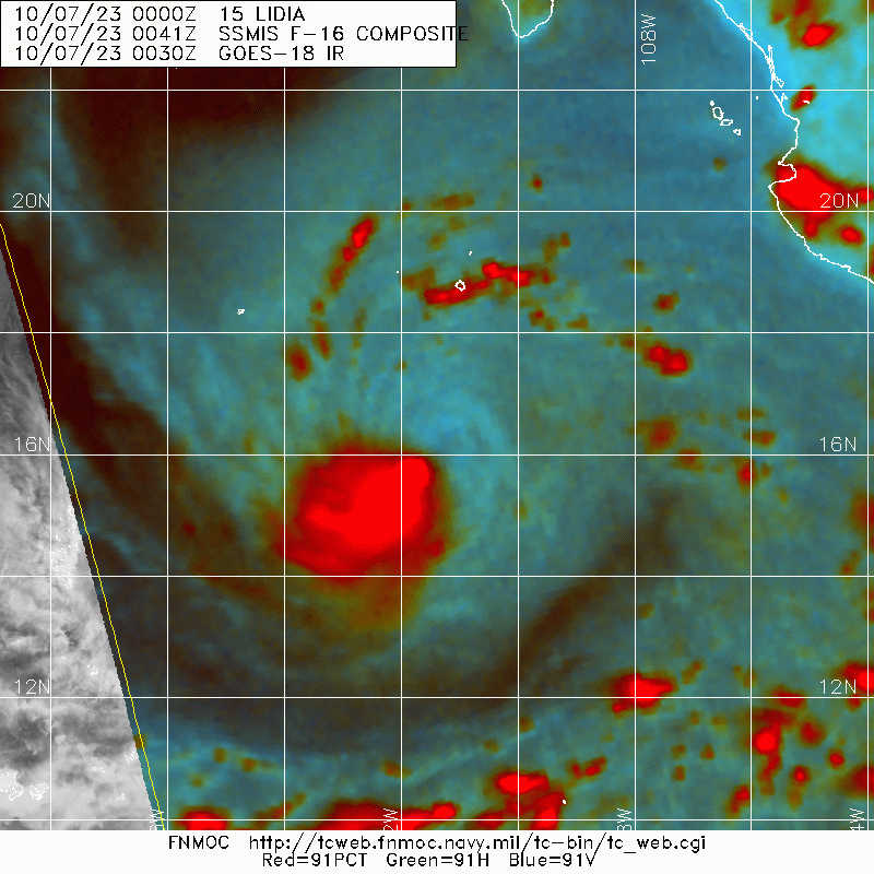
Still tilted but looks like it's trying to rotate upshear.
0 likes
RIP Kobe Bryant
-
cycloneye
- Admin
- Posts: 149836
- Age: 69
- Joined: Thu Oct 10, 2002 10:54 am
- Location: San Juan, Puerto Rico
Re: EPAC: LIDIA - Tropical Storm - Discussion
Tropical Storm Lidia Discussion Number 19
NWS National Hurricane Center Miami FL EP152023
300 PM MDT Sat Oct 07 2023
Recent partial ASCAT passes and infrared satellite imagery indicate
that the center of Lidia has been located well underneath the
large, cold convective canopy for the past several hours. This
suggests that the northeasterly to easterly shear may have
decreased slightly compared to yesterday. However, recent SSMIS and
GMI passes indicate that the structure has not improved much. The
recent ASCAT passes also suggest that the winds have not increased
yet. Despite subjective Dvorak estimates ranging from 65 to 77 kt
and objective estimates ranging from 51 to 63 kt, the intensity is
held at 55 kt for this advisory based on the ASCAT data.
There is not much change to the track forecast reasoning. The
microwave and ASCAT data indicate that Lidia has not made any
significant northward progress yet. The motion is estimated at 280/3
kt. A gradual turn to the north is expected to occur over the next
24 h, after which time, the cyclone is expected to begin interacting
with an approaching trough from the north. This interaction will
result in an acceleration early next week toward the northeast and
in the general direction of west-central Mexico. The NHC forecast is
similar to the previous forecast through 60 h, but shows a faster
northeastward motion around the time of landfall and after landfall,
and is in best agreement with the TVCE consensus aid. It should be
noted that there remains significant along-track spread in the
guidance, meaning that there is some uncertainty in the timing of
landfall.
Moderate easterly shear is likely to inhibit significant
intensification through early Sunday. However, the shear is expected
to briefly relax late Sunday through Monday night, as the cyclone
moves northward over warm sea-surface temperatures. Lidia is
therefore forecast to intensify to hurricane strength by Monday. It
should be noted that Lidia could intensify a bit more quickly than
forecast, considering the center is now well underneath the cold
convective canopy. As the storm approaches landfall in Mexico,
southwesterly shear is expected to increase, but this shear may not
have time to affect the cyclone much before it makes landfall.
Furthermore, it should be noted that the deterministic GFS global
model depicts very low central pressures, suggesting Lidia could
maintain hurricane intensity through landfall. Other reliable
statistical models and consensus aids are not as aggressive. The NHC
forecast is similar to the prior forecast, except it brings Lidia to
hurricane strength a bit sooner. Confidence in the intensity
forecast is below average. Interests in west-central Mexico should
remain attentive to forecast updates in the coming days.
FORECAST POSITIONS AND MAX WINDS
INIT 07/2100Z 16.1N 112.5W 55 KT 65 MPH
12H 08/0600Z 16.6N 112.7W 55 KT 65 MPH
24H 08/1800Z 17.4N 112.8W 60 KT 70 MPH
36H 09/0600Z 18.2N 112.5W 60 KT 70 MPH
48H 09/1800Z 18.8N 111.6W 65 KT 75 MPH
60H 10/0600Z 19.3N 110.0W 65 KT 75 MPH
72H 10/1800Z 20.3N 107.7W 65 KT 75 MPH
96H 11/1800Z 22.9N 103.3W 40 KT 45 MPH...INLAND
120H 12/1800Z...DISSIPATED
$$
Forecaster Hagen/Berg
0 likes
Visit the Caribbean-Central America Weather Thread where you can find at first post web cams,radars
and observations from Caribbean basin members Click Here
and observations from Caribbean basin members Click Here
-
Sciencerocks
- Category 5
- Posts: 10194
- Age: 40
- Joined: Thu Jul 06, 2017 1:51 am

-
Hurricane2022
- Category 5
- Posts: 2096
- Joined: Tue Aug 23, 2022 11:38 pm
- Location: Araçatuba, Brazil
Re: EPAC: LIDIA - Tropical Storm - Discussion
0 likes
Sorry for the bad English sometimes...!
For reliable and detailed information for any meteorological phenomenon, please consult the National Hurricane Center, Joint Typhoon Warning Center , or your local Meteo Center.
--------
ECCE OMNIA NOVA FACIAM (Ap 21,5).
For reliable and detailed information for any meteorological phenomenon, please consult the National Hurricane Center, Joint Typhoon Warning Center , or your local Meteo Center.
--------
ECCE OMNIA NOVA FACIAM (Ap 21,5).
-
Kingarabian
- S2K Supporter
- Posts: 16383
- Joined: Sat Aug 08, 2009 3:06 am
- Location: Honolulu, Hawaii
Re: EPAC: LIDIA - Tropical Storm - Discussion
Eyewall has developed. Would call this a hurricane now.
1 likes
RIP Kobe Bryant
-
cycloneye
- Admin
- Posts: 149836
- Age: 69
- Joined: Thu Oct 10, 2002 10:54 am
- Location: San Juan, Puerto Rico
Re: EPAC: LIDIA - Tropical Storm - Discussion
Not yet.
EP, 15, 2023100800, , BEST, 0, 160N, 1125W, 60, 990, TS
0 likes
Visit the Caribbean-Central America Weather Thread where you can find at first post web cams,radars
and observations from Caribbean basin members Click Here
and observations from Caribbean basin members Click Here
-
Sciencerocks
- Category 5
- Posts: 10194
- Age: 40
- Joined: Thu Jul 06, 2017 1:51 am

-
Yellow Evan

- Professional-Met

- Posts: 16257
- Age: 27
- Joined: Fri Jul 15, 2011 12:48 pm
- Location: Henderson, Nevada/Honolulu, HI
- Contact:
Re: EPAC: LIDIA - Tropical Storm - Discussion
Favorable trough interaction will probably yield a solid amount of strengthening for a period before the jet shears. I would be surprised if we didn’t get a Category 2 or higher.
0 likes
Who is online
Users browsing this forum: No registered users and 73 guests