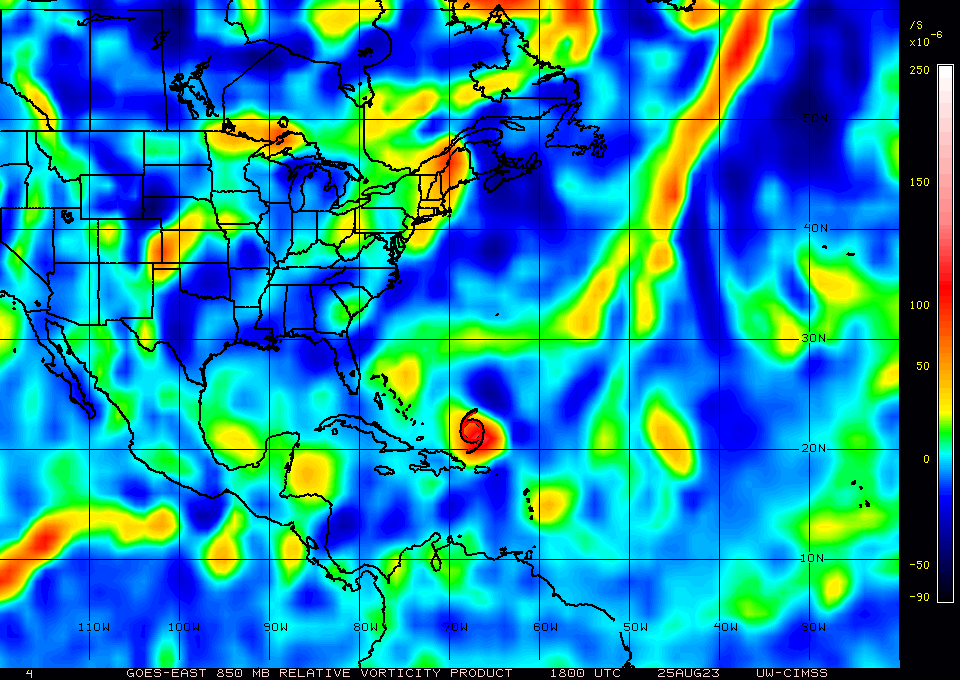
ATL: IDALIA - Post-Tropical - Discussion

Moderator: S2k Moderators

Message
Author
hipshot
Category 1
Category 1
Posts: 468
Joined: Tue Jul 06, 2010 9:18 pm
Location: Dallas, Texas

Re: ATL: INVEST 93L - Discussion

#61 Postby hipshot » Fri Aug 25, 2023 2:38 pm

wxman57 wrote:
hipshot wrote:I can't help thinking that the huge ridge over Oklahoma/Texas has to have an affect pulling this storm more towards the north and
northwest. It isn't supposed to move back west for a few days yet and our temps don't indicate it is moving much in the near term.


If the ridge stays firm, it goes farther east, not west. Ridges don't pull a storm toward them.

I thought due to the air flow of clockwise ridges with a counterclockwise low that it would pull it west if the ridge was
to its north. Thks, I didn't realize that it wouldn't steer the storm more northward.
0 likes   

User avatar
NDG
S2K Supporter
S2K Supporter
Posts: 14950
Joined: Sun Jul 09, 2006 10:14 pm
Location: Orlando, FL

Re: ATL: INVEST 93L - Discussion

#62 Postby NDG » Fri Aug 25, 2023 3:07 pm

CoC right near buoy 42056 with light winds, pitch black from storms, pressure down to 1008mb.

https://www.ndbc.noaa.gov/images/buoyca ... 5_1910.jpg

https://www.ndbc.noaa.gov/station_page. ... m=M&tz=STN
1 likes   

User avatar
gatorcane
S2K Supporter
S2K Supporter
Posts: 23499
Age: 46
Joined: Sun Mar 13, 2005 3:54 pm
Location: Boca Raton, FL

Re: ATL: INVEST 93L - Discussion

#63 Postby gatorcane » Fri Aug 25, 2023 3:10 pm

Vorticity on the increase and looks to be moving NNW:

Use the time step feature: https://tropic.ssec.wisc.edu/real-time/ ... m=&time=-4

Image
1 likes   

User avatar
NDG
S2K Supporter
S2K Supporter
Posts: 14950
Joined: Sun Jul 09, 2006 10:14 pm
Location: Orlando, FL

Re: ATL: INVEST 93L - Discussion

#64 Postby NDG » Fri Aug 25, 2023 3:11 pm

Have to love genesis of a tropical cyclone, which is coming together faster than what I was expecting.

4 likes   

Ianswfl
Category 1
Category 1
Posts: 482
Joined: Thu Mar 23, 2023 11:11 pm

Re: ATL: INVEST 93L - Discussion

#65 Postby Ianswfl » Fri Aug 25, 2023 3:20 pm

NDG wrote:Have to love genesis of a tropical cyclone, which is coming together faster than what I was expecting.

https://imgur.com/MlyNXoW


More east than most of the models. I think the Euro has a better handle on the track.
0 likes   

User avatar
GCANE
S2K Supporter
S2K Supporter
Posts: 10787
Joined: Mon Oct 22, 2007 8:03 am

Re: ATL: INVEST 93L - Discussion

#66 Postby GCANE » Fri Aug 25, 2023 3:30 pm

Getting convection firing with a lot of helicity very close or right on the LLC
1 likes   

User avatar
cycloneye
Admin
Admin
Posts: 139695
Age: 67
Joined: Thu Oct 10, 2002 10:54 am
Location: San Juan, Puerto Rico

Re: ATL: INVEST 93L - Discussion

#67 Postby cycloneye » Fri Aug 25, 2023 3:35 pm

1 likes   
Visit the Caribbean-Central America Weather Thread where you can find at first post web cams,radars
and observations from Caribbean basin members Click Here

User avatar
Blown Away
S2K Supporter
S2K Supporter
Posts: 9876
Joined: Wed May 26, 2004 6:17 am

Re: ATL: INVEST 93L - Discussion

#68 Postby Blown Away » Fri Aug 25, 2023 3:37 pm

GCANE wrote:Getting convection firing with a lot of helicity very close or right on the LLC


What lat/long do you see the LLC?
0 likes   
Hurricane Eye Experience: David 79, Irene 99, Frances 04, Jeanne 04, Wilma 05... EYE COMING MY WAY IN 2024…
Hurricane Brush Experience: Andrew 92, Erin 95, Floyd 99, Matthew 16, Irma 17, Ian 22, Nicole 22…

User avatar
GCANE
S2K Supporter
S2K Supporter
Posts: 10787
Joined: Mon Oct 22, 2007 8:03 am

Re: ATL: INVEST 93L - Discussion

#69 Postby GCANE » Fri Aug 25, 2023 3:39 pm

Blown Away wrote:
GCANE wrote:Getting convection firing with a lot of helicity very close or right on the LLC


What lat/long do you see the LLC?


18.5N 86W
0 likes   

User avatar
Nimbus
Category 5
Category 5
Posts: 4935
Joined: Mon Jul 19, 2004 10:54 am

Re: ATL: INVEST 93L - Discussion

#70 Postby Nimbus » Fri Aug 25, 2023 3:39 pm

GCANE wrote:Getting convection firing with a lot of helicity very close or right on the LLC


The convection is near 18.5N -86W light shear from the south may have displaced that a little.
Euro closed off a low near 19.7N at 18 hours tomorrow and 12Z GFS closed the low off near 18.5N but at 18 hours.
Might be good news but wait and see how it moves, whether the 12ZGFS trough break was an anomalous run.
0 likes   

User avatar
gatorcane
S2K Supporter
S2K Supporter
Posts: 23499
Age: 46
Joined: Sun Mar 13, 2005 3:54 pm
Location: Boca Raton, FL

Re: ATL: INVEST 93L - Discussion

#71 Postby gatorcane » Fri Aug 25, 2023 3:42 pm

New Levi Cowan video where he explains all the factors:


Link: https://youtu.be/qHRnrXIV2V8
2 likes   

BobHarlem
Category 5
Category 5
Posts: 1669
Joined: Thu Oct 20, 2005 6:11 pm

Re: ATL: INVEST 93L - Discussion

#72 Postby BobHarlem » Fri Aug 25, 2023 3:46 pm

Image
0 likes   

User avatar
GCANE
S2K Supporter
S2K Supporter
Posts: 10787
Joined: Mon Oct 22, 2007 8:03 am

Re: ATL: INVEST 93L - Discussion

#73 Postby GCANE » Fri Aug 25, 2023 3:47 pm

Too much outflow boundaries from the heavy convection to the north for it to take off.
Once that dies down, should see some good convection over the LLC.
1 likes   

User avatar
Steve
S2K Supporter
S2K Supporter
Posts: 8611
Joined: Sat Apr 05, 2003 11:41 pm
Location: Not a state-caster

Re: ATL: INVEST 93L - Discussion

#74 Postby Steve » Fri Aug 25, 2023 3:59 pm

Ianswfl wrote:
NDG wrote:Have to love genesis of a tropical cyclone, which is coming together faster than what I was expecting.

https://imgur.com/MlyNXoW


More east than most of the models. I think the Euro has a better handle on the track.


That’s because it’s going to take a couple of days to organize. I always thought it would go south or west of the Big Bend/armpit area. Not sure if you are down there but your alias references SWFL and have a few posts leaning that way.
0 likes   

Sciencerocks
Category 5
Category 5
Posts: 7311
Age: 38
Joined: Thu Jul 06, 2017 1:51 am

Re: ATL: INVEST 93L - Discussion

#75 Postby Sciencerocks » Fri Aug 25, 2023 4:17 pm

Image
1 likes   

User avatar
wxman57
Moderator-Pro Met
Moderator-Pro Met
Posts: 22512
Age: 66
Joined: Sat Jun 21, 2003 8:06 pm
Location: Houston, TX (southwest)

Re: ATL: INVEST 93L - Discussion

#76 Postby wxman57 » Fri Aug 25, 2023 4:18 pm

FireRat wrote:
wxman57 wrote:I still see an upper trof to its west in the NE Gulf with SW wind shear across the top Tuesday night/Wed. No anticyclone over it.


Hopefully you're right 57, we definitely don't need to lose yet another I name!


I have it passing north of Jacksonville and Savannah and cutting across Charleston Thursday.
1 likes   

Ianswfl
Category 1
Category 1
Posts: 482
Joined: Thu Mar 23, 2023 11:11 pm

Re: ATL: INVEST 93L - Discussion

#77 Postby Ianswfl » Fri Aug 25, 2023 4:34 pm

Steve wrote:
Ianswfl wrote:
NDG wrote:Have to love genesis of a tropical cyclone, which is coming together faster than what I was expecting.

https://imgur.com/MlyNXoW


More east than most of the models. I think the Euro has a better handle on the track.


That’s because it’s going to take a couple of days to organize. I always thought it would go south or west of the Big Bend/armpit area. Not sure if you are down there but your alias references SWFL and have a few posts leaning that way.


ICON just shifted back east to landfall Venice Sarasota area 996mb. What is to note on the ICOn 18z is more moisture. It looks better organized than past runs despite landfall further south. Maybe a trend towards more favorable environment?
2 likes   

User avatar
GCANE
S2K Supporter
S2K Supporter
Posts: 10787
Joined: Mon Oct 22, 2007 8:03 am

Re: ATL: INVEST 93L - Discussion

#78 Postby GCANE » Fri Aug 25, 2023 4:47 pm

All the heavy convection to the north of the LLC and popups over Honduras is helping to reinforce the anticyclone and moisten the mid-levels of the troposphere.
0 likes   

User avatar
robbielyn
Category 5
Category 5
Posts: 1239
Joined: Wed May 07, 2003 9:45 am
Location: brooksville, fl

Re: ATL: INVEST 93L - Discussion

#79 Postby robbielyn » Fri Aug 25, 2023 4:50 pm

I like Levi Cowan’s youtube videos the best. He tells us things the others don’t. Here we r thinking this is rapidly organizing compared to what we thought, and it turns what looks like organization is thunderstorms bubbling up but collapsing because the dry stable air coming from franklin is impeding sustained thunderstorms temporarily til a couple of days. Him and NHC are the ones to rely on for explaining conditions in the atmosphere in clear yet very fine detail. He doesn’t always say what i’m hoping to hear but I know it’s reliable.
2 likes   
Robbielyn McCrary
I know just about enough to sound like I know what I'm talking about sometimes. But for your safety please follow the nhc for truly professional forecasting. :D

User avatar
GCANE
S2K Supporter
S2K Supporter
Posts: 10787
Joined: Mon Oct 22, 2007 8:03 am

Re: ATL: INVEST 93L - Discussion

#80 Postby GCANE » Fri Aug 25, 2023 4:53 pm

The 00Z runs tomorrow should give a good picture of what will happen the GoM
0 likes   


Return to “2023”

Who is online

Users browsing this forum: No registered users and 2 guests