

TXPZ21 KNES 010629
TCSENP
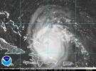
A. 05E (NONAME)
B. 01/0600Z
C. 15.8N
D. 106.4W
E. THREE/GOES-W
F. T2.5/2.5
G. IR/EIR/SWIR
H. REMARKS...LOW CONFIDENCE IN CENTER LOCATION. SYSTEM IS CHARACTERIZED
BY A CENTRAL COLD COVER (CCC) WHICH DOES NOT ALLOW FOR A DT. MET IS 2.0
BASED ON DEVELOPING TREND. PT IS 2.5. THE FT IS BASED ON THE PT BECAUSE
AN ADJUSTMENT TO THE MET WAS MADE.
I. ADDL POSITIONS
NIL
...TURK
TCSENP
A. 05E (NONAME)
B. 01/0600Z
C. 15.8N
D. 106.4W
E. THREE/GOES-W
F. T2.5/2.5
G. IR/EIR/SWIR
H. REMARKS...LOW CONFIDENCE IN CENTER LOCATION. SYSTEM IS CHARACTERIZED
BY A CENTRAL COLD COVER (CCC) WHICH DOES NOT ALLOW FOR A DT. MET IS 2.0
BASED ON DEVELOPING TREND. PT IS 2.5. THE FT IS BASED ON THE PT BECAUSE
AN ADJUSTMENT TO THE MET WAS MADE.
I. ADDL POSITIONS
NIL
...TURK


