
29.65 mb at the buoy
https://www.ndbc.noaa.gov/show_plot.php ... _label=EDT
ATL: IDALIA - Post-Tropical - Discussion
Moderator: S2k Moderators
Re: ATL: TEN - Tropical Depression - Discussion
Appears GFS is more positively tilting the trof compared to previous run.
More mid-level moisture on the storm's west flank.
Riding in more of the trof's wave break which is less shear.
Also, will be pulling more of the high CAPE air in from the west.
Currently at 7000 over a large area - pure nitro.
Add to it, tracking over the Loop Current.
Vorts are already stacked.
Hurricane models are becoming more believable.
1 likes
-
weeniepatrol

- Category 5

- Posts: 1343
- Joined: Sat Aug 22, 2020 5:30 pm
- Location: WA State
Re: ATL: TEN - Tropical Depression - Discussion
The very warm and deep waters of the northwestern Caribbean Sea and
Gulf of Mexico should support at least gradual strengthening during
the next few days, tempered by moderate shear from a flat upper-
level trough. However, this trough is forecast to amplify over the
western Gulf of Mexico around Tuesday, which causes the shear to
decrease near the cyclone in that time frame. There's a notable
risk of rapid intensification while the system moves across the
record warm eastern and northeastern Gulf of Mexico, which is
highlighted by the recent HAFS and HWRF guidance. The new NHC
forecast is raised from the previous one, near or above the model
consensus, and could be too low. I'm reluctant to make any big
changes to the forecast until we get more in-situ data, but the
upward overnight model trend certainly bears watching. Users are
reminded to continue monitoring forecasts for any changes to the
system's expected intensity as it approaches Florida.
5 likes

Re: ATL: TEN - Tropical Depression - Discussion
weeniepatrol wrote::eek: The very warm and deep waters of the northwestern Caribbean Sea and
Gulf of Mexico should support at least gradual strengthening during
the next few days, tempered by moderate shear from a flat upper-
level trough. However, this trough is forecast to amplify over the
western Gulf of Mexico around Tuesday, which causes the shear to
decrease near the cyclone in that time frame. There's a notable
risk of rapid intensification while the system moves across the
record warm eastern and northeastern Gulf of Mexico, which is
highlighted by the recent HAFS and HWRF guidance. The new NHC
forecast is raised from the previous one, near or above the model
consensus, and could be too low. I'm reluctant to make any big
changes to the forecast until we get more in-situ data, but the
upward overnight model trend certainly bears watching. Users are
reminded to continue monitoring forecasts for any changes to the
system's expected intensity as it approaches Florida.
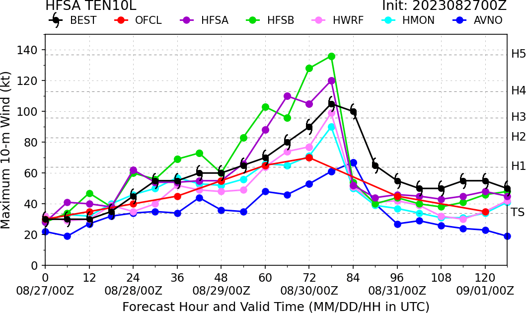
The new 80 kt (high-end Cat 1) peak forecast could still be too low... Wow.
1 likes
TC naming lists: retirements and intensity
Most aggressive Advisory #1's in North Atlantic (cr. kevin for starting the list)
Most aggressive Advisory #1's in North Atlantic (cr. kevin for starting the list)
-
jlauderdal
- S2K Supporter

- Posts: 7240
- Joined: Wed May 19, 2004 5:46 am
- Location: NE Fort Lauderdale
- Contact:
Re: ATL: TEN - Tropical Depression - Discussion
Teban54 wrote:weeniepatrol wrote::eek:The very warm and deep waters of the northwestern Caribbean Sea and
Gulf of Mexico should support at least gradual strengthening during
the next few days, tempered by moderate shear from a flat upper-
level trough. However, this trough is forecast to amplify over the
western Gulf of Mexico around Tuesday, which causes the shear to
decrease near the cyclone in that time frame. There's a notable
risk of rapid intensification while the system moves across the
record warm eastern and northeastern Gulf of Mexico, which is
highlighted by the recent HAFS and HWRF guidance. The new NHC
forecast is raised from the previous one, near or above the model
consensus, and could be too low. I'm reluctant to make any big
changes to the forecast until we get more in-situ data, but the
upward overnight model trend certainly bears watching. Users are
reminded to continue monitoring forecasts for any changes to the
system's expected intensity as it approaches Florida.
The new 80 kt (high-end Cat 1) peak forecast could still be too low... Wow.
A major is looking more likely than not, a few days ago we were looking at a ts/td....intensity forecasting still a mystery. I will buy into the track once we see real movement towards the gulf. Panhandle, big bend down to tampa, i would fuel up this morning, too many people will be focusing on the line for this one, bad idea.
1 likes
Re: ATL: TEN - Tropical Depression - Discussion
Hopefully there will be some EWRCs along the way.
Very likely in the mid GOM
Very likely in the mid GOM
0 likes
-
Keldeo1997
- Category 2

- Posts: 688
- Joined: Fri Oct 11, 2019 11:35 pm
Re: ATL: TEN - Tropical Depression - Discussion
GCANE wrote:Hopefully there will be some EWRCs along the way.
Very likely in the mid GOM
That's not really the best thing either. Will make an already bad surge even worse.
1 likes
-
redingtonbeach
- Tropical Depression

- Posts: 65
- Joined: Mon Sep 04, 2017 12:05 am
Re: ATL: TEN - Tropical Depression - Discussion
The day when the NHC says a slap in the face may instead turn into a beating with a baseball bat.
1 likes
Re: ATL: TEN - Tropical Depression - Discussion
0 likes
TC naming lists: retirements and intensity
Most aggressive Advisory #1's in North Atlantic (cr. kevin for starting the list)
Most aggressive Advisory #1's in North Atlantic (cr. kevin for starting the list)
-
jlauderdal
- S2K Supporter
- Posts: 7240
- Joined: Wed May 19, 2004 5:46 am
- Location: NE Fort Lauderdale
- Contact:
Re: ATL: TEN - Tropical Depression - Discussion
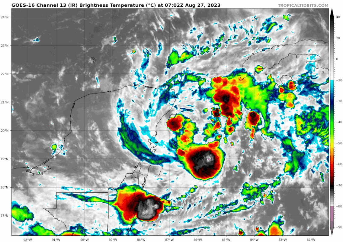
IR weenies wouldnt be real excited about that but of course that doesn't tell the whole story. We get recon so let's see what is going on underneath those cool colors.
0 likes

Re: ATL: TEN - Tropical Depression - Discussion
Pretty soon we'll have an idea what's going on "under the hood", so to speak but I'm thinking we'll be seeing Idalia once recon arrives...
4 likes

Re: ATL: TEN - Tropical Depression - Discussion
I have a bad feeling about this one similar to the early stages of Michael and Ian. I hope it doesn't become nearly as bad as those, but late August GOM trouble is always scary. Next few days with Franklin and future Idalia will be busy days on Storm2k, peak season has started.
2 likes
Re: ATL: TEN - Tropical Depression - Discussion
Looks like Miss Piggy having its usual Comm issues
0 likes
-
jlauderdal
- S2K Supporter
- Posts: 7240
- Joined: Wed May 19, 2004 5:46 am
- Location: NE Fort Lauderdale
- Contact:
Re: ATL: TEN - Tropical Depression - Discussion
GCANE wrote:Looks like Miss Piggy having its usual Comm issues
All year to get this stuff working correctly, recon issues are too common.
1 likes
-
Blown Away

- S2K Supporter
- Posts: 10253
- Joined: Wed May 26, 2004 6:17 am
Re: ATL: TEN - Tropical Depression - Discussion
GCANE wrote:Looks like Miss Piggy having its usual Comm issues
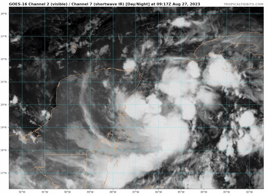
GCANE, do you think the broad COC is consolidating a bit SE from the 06z position?
0 likes
Hurricane Eye Experience: David 79, Irene 99, Frances 04, Jeanne 04, Wilma 05… Hurricane Brush Experience: Andrew 92, Erin 95, Floyd 99, Matthew 16, Irma 17, Ian 22, Nicole 22…
-
Poonwalker
- Category 1

- Posts: 270
- Joined: Tue Sep 20, 2022 11:12 am
Re: ATL: TEN - Tropical Depression - Discussion
LandoWill wrote:didnt expect to see tampa out of the cone already. interesting
The way stronger storms jog east on the last day is not good news for Tampa. (Charley, Irma, Ian)
Last edited by Poonwalker on Sun Aug 27, 2023 5:47 am, edited 2 times in total.
0 likes
Re: ATL: TEN - Tropical Depression - Discussion
Blown Away wrote:GCANE wrote:Looks like Miss Piggy having its usual Comm issues
[url]https://i.postimg.cc/9MCCMKpY/goes16-vis-swir-10-L-202308270917.gif [/url]
GCANE, do you think the broad COC is consolidating a bit SE from the 06z position?
Definitely, maybe a little more than just a bit
4 likes
Re: ATL: TEN - Tropical Depression - Discussion
GCANE wrote:Blown Away wrote:GCANE wrote:Looks like Miss Piggy having its usual Comm issues
[url]https://i.postimg.cc/9MCCMKpY/goes16-vis-swir-10-L-202308270917.gif [/url]
GCANE, do you think the broad COC is consolidating a bit SE from the 06z position?
Definitely, maybe a little more than just a bit
And way off the forecast track
https://tropic.ssec.wisc.edu/real-time/ ... Table.html
2 likes
Who is online
Users browsing this forum: No registered users and 30 guests