ATL: CINDY - Remnants - Discussion
Moderator: S2k Moderators

Re: ATL: INVEST 93L - Discussion
Just a day ago 93L was almost devoid of any convection. Now it can almost pass as a TD.
2 likes
TC naming lists: retirements and intensity
Most aggressive Advisory #1's in North Atlantic (cr. kevin for starting the list)
Most aggressive Advisory #1's in North Atlantic (cr. kevin for starting the list)

Re: ATL: INVEST 93L - Discussion
In the last hour or two a tight low level center can clearly be seen forming on the eastern side of the convection…if the convection can bounce back this afternoon I would expect this to be designated later today.
0 likes
-
TheAustinMan

- Category 5

- Posts: 1060
- Joined: Mon Jul 08, 2013 4:26 pm
- Location: Central TX / United States
Re: ATL: INVEST 93L - Discussion
Sciencerocks wrote:https://imagizer.imageshack.com/img922/2899/SUpN3X.gif
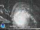
Based on low-level cloud motions shown on the visible satellite imagery, a tightly-wound circulation center appears to have developed on the eastern side of the convective activity associated with 93L. Convection overall is currently not very deep (around -55°C cloud tops at best near the storm center), but the overall structure suggests that 93L is very close to if not already adequately organized to be classified as a tropical depression. Scatterometer data suggest a current peak sustained winds of around 25-30 kt.
4 likes
Treat my opinions with a grain of salt. For official information see your local weather service.
“It's tough to make predictions, especially about the future.”
“It's tough to make predictions, especially about the future.”
-
ScottNAtlanta

- Category 5
- Posts: 2535
- Joined: Sat May 25, 2013 3:11 pm
- Location: Atlanta, GA
Re: ATL: INVEST 93L - Discussion
WiscoWx02 wrote:In the last hour or two a tight low level center can clearly be seen forming on the eastern side of the convection…if the convection can bounce back this afternoon I would expect this to be designated later today.
Looks like some convection is starting to fire over that center
2 likes
The posts in this forum are NOT official forecast and should not be used as such. They are just the opinion of the poster and may or may not be backed by sound meteorological data. They are NOT endorsed by any professional institution or storm2k.org. For official information, please refer to the NHC and NWS products.
Re: ATL: INVEST 93L - Discussion
ScottNAtlanta wrote:WiscoWx02 wrote:In the last hour or two a tight low level center can clearly be seen forming on the eastern side of the convection…if the convection can bounce back this afternoon I would expect this to be designated later today.
Looks like some convection is starting to fire over that center
I’ve been keeping an eye on that…if it remains persistent maybe we see a TD designation.
0 likes
-
Kingarabian

- S2K Supporter

- Posts: 16383
- Joined: Sat Aug 08, 2009 3:06 am
- Location: Honolulu, Hawaii
Re: ATL: INVEST 93L - Discussion
Looks to me this is already a TD and on its way to becoming named.
2 likes
RIP Kobe Bryant
-
Sciencerocks
- Category 5
- Posts: 10194
- Age: 40
- Joined: Thu Jul 06, 2017 1:51 am

-
cycloneye

- Admin

- Posts: 149813
- Age: 69
- Joined: Thu Oct 10, 2002 10:54 am
- Location: San Juan, Puerto Rico
Re: ATL: INVEST 93L - Discussion
Central Tropical Atlantic (AL93):
Recent satellite-derived wind data indicate the area of low
pressure located about midway between the west coast of Africa and
the Lesser Antilles has an elongated surface circulation
with maximum sustained winds of about 30 mph. However, showers
and thunderstorms continue to show signs of organization, and
environmental conditions appear conducive for further development.
Therefore, a tropical depression will likely form during the next
day or so while the system moves westward to west-northwestward at
10 to 15 mph across the central tropical Atlantic through the early
part of the weekend.
* Formation chance through 48 hours...high...70 percent.
* Formation chance through 7 days...high...80 percent.
0 likes
Visit the Caribbean-Central America Weather Thread where you can find at first post web cams,radars
and observations from Caribbean basin members Click Here
and observations from Caribbean basin members Click Here
-
cycloneye
- Admin
- Posts: 149813
- Age: 69
- Joined: Thu Oct 10, 2002 10:54 am
- Location: San Juan, Puerto Rico
Re: ATL: INVEST 93L - Discussion
AL, 93, 2023062118, , BEST, 0, 105N, 391W, 25, 1009, LO
0 likes
Visit the Caribbean-Central America Weather Thread where you can find at first post web cams,radars
and observations from Caribbean basin members Click Here
and observations from Caribbean basin members Click Here

Re: ATL: INVEST 93L - Discussion
Not sure why they're not upgrading, seems pretty clearly a depression at this point
4 likes
The above post is not official and should not be used as such. It is the opinion of the poster and may or may not be backed by sound meteorological data. It is not endorsed by any professional institution or storm2k.org. For official information, please refer to the NHC and NWS products.

Re: ATL: INVEST 93L - Discussion
Hammy wrote:Not sure why they're not upgrading, seems pretty clearly a depression at this point
I hope this doesn’t end up as another never-upgraded-but-clearly-a-TC invest like the several last year, and that unnamed January subtropical storm for like 5 months.
Edit: I can see parts of an LLC on visible, and there are hot towers popping over it.
4 likes
Irene '11 Sandy '12 Hermine '16 5/15/2018 Derecho Fay '20 Isaias '20 Elsa '21 Henri '21 Ida '21
I am only a meteorology enthusiast who knows a decent amount about tropical cyclones. Look to the professional mets, the NHC, or your local weather office for the best information.
I am only a meteorology enthusiast who knows a decent amount about tropical cyclones. Look to the professional mets, the NHC, or your local weather office for the best information.
-
Sciencerocks
- Category 5
- Posts: 10194
- Age: 40
- Joined: Thu Jul 06, 2017 1:51 am
Re: ATL: INVEST 93L - Discussion
I'd agree that this is a depression. That subtropical system back in january was far from subtropical! It was a full blown hurricane roaring towards canada.
0 likes
-
TheAustinMan
- Category 5
- Posts: 1060
- Joined: Mon Jul 08, 2013 4:26 pm
- Location: Central TX / United States
Re: ATL: INVEST 93L - Discussion
A GMI overpass of the system at 20:56 UTC provided the following microwave imagery of Invest 93L, which shows organized, low-level cumulus banding suggestive of a well-defined center of circulation. Barring a considerable decline in convective organization or an unexpectedly ill-defined wind field captured by scatterometer data, I would anticipate that 93L would be designated tropical depression sometime tonight or tomorrow morning. The wording of the most recent NHC Tropical Weather Outlook, while not quite at the "any increase in organization..." verbiage, does seem to suggest that they're prepared to initiate advisories on the system within the next day.*
89 GHz and 37 GHz imagery from GMI/GPM. Click to expand. Source: FNMOC


The posts in this forum are NOT official forecasts and should not be used as such. They are just the opinion of the poster and may or may not be backed by sound meteorological data. They are NOT endorsed by any professional institution or STORM2K. For official information, please refer to products from the NHC and NWS.
89 GHz and 37 GHz imagery from GMI/GPM. Click to expand. Source: FNMOC
6 likes
Treat my opinions with a grain of salt. For official information see your local weather service.
“It's tough to make predictions, especially about the future.”
“It's tough to make predictions, especially about the future.”
-
NotSparta

- Professional-Met

- Posts: 1677
- Age: 24
- Joined: Fri Aug 18, 2017 8:24 am
- Location: Naples, FL
- Contact:
Re: ATL: INVEST 93L - Discussion
I'd imagine 93L will end up designated at some point. It'll be around for a while longer so unless development reverses and doesn't recover it should be a TD in the near term
3 likes
This post was probably an opinion of mine, and in no way is official. Please refer to http://www.hurricanes.gov for official tropical analysis and advisories.
My website, with lots of tropical wx graphics, including satellite and recon: http://cyclonicwx.com
My website, with lots of tropical wx graphics, including satellite and recon: http://cyclonicwx.com

Re: ATL: INVEST 93L - Discussion
Sciencerocks wrote:I'd agree that this is a depression. That subtropical system back in january was far from subtropical! It was a full blown hurricane roaring towards canada.
The fact that they gave a system with an eyewall heading towards a populated area a 20/20 chance of development at the time was baffling. At least 93L isn’t going to harm anyone, but it would be nice to have a more accurate operational formation date, and for clear TCs to get upgraded regardless of impacts for the sake of complete seasonal data. It’s odd to see how the NHC has missed several systems when they were naming stuff like Odette ‘21 in previous years.
93L continues to look better, so I hope it’s upped to 90/90 or 100/100 at 8pm with the NHC saying “any increase in organization should lead to advisories being initiated”. They can revise its genesis to 18z today in post-season if they need to.
4 likes
Irene '11 Sandy '12 Hermine '16 5/15/2018 Derecho Fay '20 Isaias '20 Elsa '21 Henri '21 Ida '21
I am only a meteorology enthusiast who knows a decent amount about tropical cyclones. Look to the professional mets, the NHC, or your local weather office for the best information.
I am only a meteorology enthusiast who knows a decent amount about tropical cyclones. Look to the professional mets, the NHC, or your local weather office for the best information.
-
MGC

- S2K Supporter
- Posts: 5941
- Joined: Sun Mar 23, 2003 9:05 pm
- Location: Pass Christian MS, or what is left.
Re: ATL: INVEST 93L - Discussion
Needs a bit more convection and a tighter circulation to become a TD. Should get there by tomorrow morning IMO........MGC
0 likes
-
Sciencerocks
- Category 5
- Posts: 10194
- Age: 40
- Joined: Thu Jul 06, 2017 1:51 am

-
cycloneye
- Admin
- Posts: 149813
- Age: 69
- Joined: Thu Oct 10, 2002 10:54 am
- Location: San Juan, Puerto Rico
Re: ATL: INVEST 93L - Discussion
Tropical Weather Outlook
NWS National Hurricane Center Miami FL
800 PM EDT Wed Jun 21 2023
For the North Atlantic...Caribbean Sea and the Gulf of Mexico:
Active Systems:
The National Hurricane Center is issuing advisories on Tropical
Storm Bret, located several hundred miles east of the Windward
Islands.
Central Tropical Atlantic (AL93):
Showers and thunderstorms continue to show signs of organization in
association with the area of low pressure located about midway
between the west coast of Africa and the Lesser Antilles, and
environmental conditions appear conducive for further development.
Therefore, a tropical depression will likely form during the next
day or so while the system moves westward to west-northwestward at
10 to 15 mph across the central tropical Atlantic through the early
part of the weekend.
* Formation chance through 48 hours...high...80 percent.
* Formation chance through 7 days...high...90 percent.
$$
Forecaster Kelly/Reinhart
0 likes
Visit the Caribbean-Central America Weather Thread where you can find at first post web cams,radars
and observations from Caribbean basin members Click Here
and observations from Caribbean basin members Click Here
Re: ATL: INVEST 93L - Discussion
Another instance where we really need ASCAT, but alas, we’re seemingly not getting any passes.
I wonder when the TROPICS constellation is going to be ready. The remaining 4 satellites were launched back in May. They should give us more frequent data and hopefully hit storms more often than ASCAT.
I wonder when the TROPICS constellation is going to be ready. The remaining 4 satellites were launched back in May. They should give us more frequent data and hopefully hit storms more often than ASCAT.
2 likes
Irene '11 Sandy '12 Hermine '16 5/15/2018 Derecho Fay '20 Isaias '20 Elsa '21 Henri '21 Ida '21
I am only a meteorology enthusiast who knows a decent amount about tropical cyclones. Look to the professional mets, the NHC, or your local weather office for the best information.
I am only a meteorology enthusiast who knows a decent amount about tropical cyclones. Look to the professional mets, the NHC, or your local weather office for the best information.
Who is online
Users browsing this forum: No registered users and 33 guests