EPAC: HILARY - Post-Tropical - Discussion
Moderator: S2k Moderators
-
Yellow Evan

- Professional-Met

- Posts: 16257
- Age: 27
- Joined: Fri Jul 15, 2011 12:48 pm
- Location: Henderson, Nevada/Honolulu, HI
- Contact:
Re: EPAC: HILARY - Hurricane - Discussion
Quickly decoupling. Barely meets the definition of a TC where LLC only identifiable on visible (and that might not be surface based).
1 likes
-
Sciencerocks
- Category 5

- Posts: 10194
- Age: 40
- Joined: Thu Jul 06, 2017 1:51 am


Re: EPAC: HILARY - Tropical Storm - Discussion
San Diego gas & electric reporting about 10,000 customers losing power with those first squalls. May not be too bad since transformers may just need resetting.
0 likes
-
cycloneye

- Admin

- Posts: 149825
- Age: 69
- Joined: Thu Oct 10, 2002 10:54 am
- Location: San Juan, Puerto Rico
Re: EPAC: HILARY - Tropical Storm - Discussion
Tropical Storm Hilary Discussion Number 18
NWS National Hurricane Center Miami FL EP092023
200 PM PDT Sun Aug 20 2023
Hilary made landfall over the northern Baja California Peninsula a
few hours ago with maximum winds estimated to be around 55 kt.
Since then the storm has continued to move north-northwestward with
the center now nearing the California/Mexico border. Maximum
sustained winds are now estimated to be near 50 kt based on the
earlier aircraft data and satellite estimates. Surface
observations indicate that tropical-storm-force winds have spread
into southern California and there have been a few reports of gusts
around hurricane force. In addition, radar images show that bands
of heavy rain have spread across portions of the southwestern United
States and this will continue through early Monday.
The storm is moving quickly to the north-northwest, with the latest
initial motion estimated to be 345/20 kt. An even faster motion to
the north-northwest is expected during the next day or so as Hilary
moves in the fast flow between a ridge over the south-central U.S.
and a mid- to upper-level low off the central California coast.
Little change was made to the previous track forecast.
Continued weakening due to dry air, and land interaction is
expected, but Hilary is forecast to remain a tropical storm while it
moves over southern California through tonight. The strongest winds
are expected to be to the east of the center and in areas of high
terrain.
KEY MESSAGES:
1. Preparations for flooding impacts across the Southwestern United
States should be completed with the peak intensity of heavy rainfall
expected later today through early Monday morning. The potentially
historic amount of rainfall is expected to cause life-threatening to
locally catastrophic flash, urban, and arroyo flooding including
landslides, mudslides, and debris flows through early Monday
morning. Localized flooding impacts, some significant, are also
expected across northern portions of the Intermountain West.
2. Tropical storm conditions are expected to continue across the
northern portion of the Baja California Peninsula within the
Tropical Storm Warning area during the next few hours.
3. Tropical storm conditions are expected in portions of the
southwestern U.S. within the Tropical Storm Warning
area through tonight. Winds could be particularly strong and
gusty in and near areas of higher terrain. Gusty winds are
expected to spread well inland across the western United States.
4. Large swells generated by Hilary will affect portions of the
Baja California Peninsula and southern California over the next
day or so. These swells are likely to cause life-threatening
surf and rip current conditions.
FORECAST POSITIONS AND MAX WINDS
INIT 20/2100Z 31.3N 116.1W 50 KT 60 MPH
12H 21/0600Z 35.8N 117.2W 35 KT 40 MPH
24H 21/1800Z 41.8N 117.3W 25 KT 30 MPH...POST-TROP/INLAND
36H 22/0600Z...DISSIPATED
$$
Forecaster Cangialosi
0 likes
Visit the Caribbean-Central America Weather Thread where you can find at first post web cams,radars
and observations from Caribbean basin members Click Here
and observations from Caribbean basin members Click Here
-
Sciencerocks
- Category 5
- Posts: 10194
- Age: 40
- Joined: Thu Jul 06, 2017 1:51 am

-
Evil Jeremy

- S2K Supporter

- Posts: 5463
- Age: 32
- Joined: Mon Apr 10, 2006 2:10 pm
- Location: Los Angeles, CA
Re: EPAC: HILARY - Tropical Storm - Discussion
Just had an earthquake, felt on LA westside. At the same time as a Tropical Storm. Incredible.
4 likes
Frances 04 / Jeanne 04 / Katrina 05 / Wilma 05 / Fay 08 / Debby 12 / Andrea 13 / Colin 16 / Hermine 16 / Matthew 16 / Irma 17
Re: EPAC: HILARY - Tropical Storm - Discussion
Mark is out in Yucca Valley, watching water rise over the road
https://www.youtube.com/watch?v=-v9Aodi6GJo
[youtube]http://youtu.be/-v9Aodi6GJo[/youtube]
https://www.youtube.com/watch?v=-v9Aodi6GJo
[youtube]http://youtu.be/-v9Aodi6GJo[/youtube]
0 likes
-
Hybridstorm_November2001

- S2K Supporter
- Posts: 2817
- Joined: Sat Aug 21, 2004 2:50 pm
- Location: SW New Brunswick, Canada
- Contact:
Re: EPAC: HILARY - Tropical Storm - Discussion
Truly incredible, I never thought I'd watch a tropical system directly impact LA in my lifetime. A year of extremes. 
1 likes

Re: EPAC: HILARY - Tropical Storm - Discussion
Inland California near the Salton Sea is getting tropical storm conditions while San Diego is seeing light winds.
The Imperial County Airport, near the Salton Sea has seen gusts over 50 mph.
https://www.weather.gov/wrh/timeseries?site=KIPL
The Imperial County Airport, near the Salton Sea has seen gusts over 50 mph.
https://www.weather.gov/wrh/timeseries?site=KIPL
0 likes
-
Sciencerocks
- Category 5
- Posts: 10194
- Age: 40
- Joined: Thu Jul 06, 2017 1:51 am
Re: EPAC: HILARY - Tropical Storm - Discussion
Center has moved into southern Califorina. Tropical storm in Califoria!

2 likes
-
Sciencerocks
- Category 5
- Posts: 10194
- Age: 40
- Joined: Thu Jul 06, 2017 1:51 am

-
Bocadude85

- Category 5
- Posts: 2991
- Age: 39
- Joined: Mon Apr 18, 2005 2:20 pm
- Location: Honolulu,Hi
Re: EPAC: HILARY - Tropical Storm - Discussion
Nothing more then moderate rain here in Ventura, so nothing to crazy from Hilary. However we did have a 5.1 earthquake about 2 hours ago that was fairly violent here in Ventura.
1 likes
-
Sciencerocks
- Category 5
- Posts: 10194
- Age: 40
- Joined: Thu Jul 06, 2017 1:51 am
Re: EPAC: HILARY - Tropical Storm - Discussion
Officially, a tropical storm over Califorina!!!!!
BULLETIN
Tropical Storm Hilary Intermediate Advisory Number 18A
NWS National Hurricane Center Miami FL EP092023
500 PM PDT Sun Aug 20 2023[b]
...CENTER OF HILARY MOVES INTO SOUTHERN CALIFORNIA...
...CATASTROPHIC AND LIFE-THREATENING FLOODING LIKELY OVER NORTHERN
BAJA CALIFORNIA AND PORTIONS OF THE SOUTHWESTERN U.S. THROUGH
MONDAY...
SUMMARY OF 500 PM PDT...0000 UTC...INFORMATION
----------------------------------------------
LOCATION...33.5N 116.7W
ABOUT 25 MI...40 KM SSW OF PALM SPRINGS CALIFORNIA
MAXIMUM SUSTAINED WINDS...50 MPH...85 KM/H
PRESENT MOVEMENT...N OR 350 DEGREES AT 23 MPH...37 KM/H
MINIMUM CENTRAL PRESSURE...997 MB...29.44 INCHES
WATCHES AND WARNINGS
--------------------
CHANGES WITH THIS ADVISORY:
The government of Mexico has discontinued the Tropical Storm
Warning south of San Jose de Las Palmas on the west coast and south
of Isla San Luis on the east coast of the Baja California Peninsula.
The warning has also been discontinue south of Puerto Libertad on
northwest coast of mainland Mexico.
SUMMARY OF WATCHES AND WARNINGS IN EFFECT:
A Tropical Storm Warning is in effect for...
* Baja California peninsula west coast from San Jose de Las Palms
northward
* Baja California peninsula east coast from Isla San Luis northward
* Mainland Mexico north of Puerto Libertad
* California/Mexico border to Point Mugu
* Catalina Island
A Tropical Storm Warning means that tropical storm conditions are
expected somewhere within the warning.
Interests elsewhere in the southwestern U.S. should monitor the
progress of Hilary.
For storm information specific to your area in the United
States, including possible inland watches and warnings, please
monitor products issued by your local National Weather Service
forecast office. For storm information specific to your area
outside of the United States, please monitor products issued by
your national meteorological service.
DISCUSSION AND OUTLOOK
----------------------
At 500 PM PDT (0000 UTC), the center of Tropical Storm Hilary was
located inland near latitude 33.5 North, longitude 116.7 West.
Hilary is moving toward the north near 23 mph (37 km/h) and the
storm is expected to accelerate even more as it moves
north-northwestward to northward during the next day or so. On the
forecast track, the center of Hilary will move across southern
California this evening.
Maximum sustained winds are near 50 mph (85 km/h) with higher
gusts. Weakening is expected to continue, and Hilary is forecast to
become a post-tropical cyclone overnight.
Tropical-storm-force winds extend outward up to 230 miles (370 km)
from the center. A sustained wind of 45 mph (72 km/h) with a gust
to 69 mph (111 km/h) was reported in Yuma, Arizona within the past
couple of hours. A sustained wind of 40 mph (65 km/h) with a gust
to 63 mph (102 km/h) was recently reported at Imperial County
Airport in Imperial, California.
The estimated minimum central pressure is 997 mb (29.44 inches).
HAZARDS AFFECTING LAND
----------------------
Key messages for Hilary can be found in the Tropical Cyclone
Discussion under AWIPS header MIATCDEP4 and WMO header WTPZ44 KNHC
and on the web at hurricanes.gov/text/MIATCDEP4.shtml.
RAINFALL: Hilary is expected to produce storm total rainfall
amounts of 3 to 6 inches, with maximum amounts up to 10 inches,
across portions of the northern Baja California Peninsula through
tonight. Flash and urban flooding, locally catastrophic, is
expected.
Intense heavy rainfall associated with Hilary is expected across the
Southwestern United States through early Monday morning. Rainfall
amounts of 3 to 6 inches, with isolated maximum amounts of 10
inches, are expected across portions of southern California and
southern Nevada leading to dangerous to catastrophic flooding.
Across portions of Oregon and Idaho, rainfall totals of 1 to 3
inches with local maxima to 5 inches are expected through Tuesday
morning, resulting in localized significant flash flooding.
A list of rainfall observations compiled by the NOAA Weather
Prediction Center for this storm can be found at:
http://www.wpc.ncep.noaa.gov/discussions/nfdscc4.html
WIND: Tropical storm conditions will continue through the evening
in the Tropical Storm Warning area in the northern portions of
the Baja California Peninsula. Tropical storm conditions will
continue into tonight in the warning area in southern California.
Winds could be particularly strong and gusty in and near areas of
elevated terrain. Higher gusts are expected well inland and will
persist even after the system becomes post-tropical.
STORM SURGE: Coastal flooding is possible along the northern coast
of the Gulf of California through early Monday.
TORNADOES: A couple tornadoes are possible through this evening over
southeast California, western Arizona, southern Nevada, and far
southwest Utah.
SURF: Large swells generated by Hilary will affect portions of the
Baja California Peninsula and southern California over the next
day or so. These swells are likely to cause life-threatening
surf and rip current conditions. Please consult products from your
local weather office.
NEXT ADVISORY
-------------
Next complete advisory at 800 PM PDT.
$$
Forecaster Brown

Last edited by Sciencerocks on Sun Aug 20, 2023 7:17 pm, edited 2 times in total.
5 likes
-
galaxy401

- Category 5
- Posts: 2446
- Age: 30
- Joined: Sat Aug 25, 2012 9:04 pm
- Location: Casa Grande, Arizona
Re: EPAC: HILARY - Tropical Storm - Discussion
Completely dry here in the Phoenix Valley. It's been cloudy at least providing a nice break from the heat but no rain around here. Has gotten windy though with 20 mph sustained.
0 likes
Got my eyes on moving right into Hurricane Alley: Florida.
-
wxman57

- Moderator-Pro Met

- Posts: 23177
- Age: 68
- Joined: Sat Jun 21, 2003 8:06 pm
- Location: Houston, TX (southwest)
Re: EPAC: HILARY - Tropical Storm - Discussion
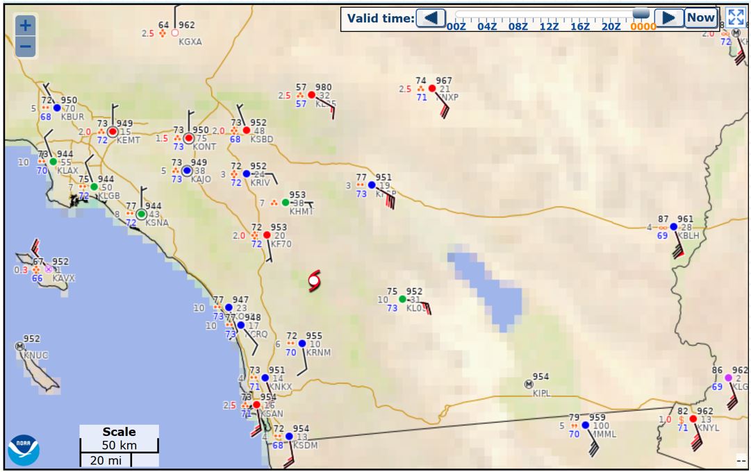
Observations over southern CA do not indicate that Hilary still has a low level circulation center. Light southerly wind west of the NHC's position of the center, stronger SE-SSE wind to the east. I don't think there's a TS over California. Remnants of one, though. Could use some of that rain here.
3 likes


Re: EPAC: HILARY - Tropical Storm - Discussion
First time I can recall seeing the State of Idaho in the cone.

5 likes
-
Yellow Evan
- Professional-Met
- Posts: 16257
- Age: 27
- Joined: Fri Jul 15, 2011 12:48 pm
- Location: Henderson, Nevada/Honolulu, HI
- Contact:
Re: EPAC: HILARY - Tropical Storm - Discussion
Surface obs suggest Hilary’s LLC either dissipated or moved offshore. Definitely crossed into California though given past surface observations of westerlies.
0 likes
-
bob rulz
- Category 5
- Posts: 1711
- Age: 36
- Joined: Sat Jan 28, 2006 7:30 pm
- Location: Salt Lake City, Utah
Re: EPAC: HILARY - Tropical Storm - Discussion
Sadly the rain shield has stayed west of me for the time being, aside from one short round of thunderstorms moving in overnight.
We do have an elevated risk of monsoon thunderstorms for the rest of the week, likely due to the pattern change Hilary has brought to the area, but as of now, at least in Salt Lake City, it doesn't look like anything particularly unusual for this time of year.
We do have an elevated risk of monsoon thunderstorms for the rest of the week, likely due to the pattern change Hilary has brought to the area, but as of now, at least in Salt Lake City, it doesn't look like anything particularly unusual for this time of year.
0 likes
-
wxman57
- Moderator-Pro Met
- Posts: 23177
- Age: 68
- Joined: Sat Jun 21, 2003 8:06 pm
- Location: Houston, TX (southwest)
Re: EPAC: HILARY - Tropical Storm - Discussion
Yellow Evan wrote:Surface obs suggest Hilary’s LLC either dissipated or moved offshore. Definitely crossed into California though given past surface observations of westerlies.
Coastal obs now suggest a center offshore south of Long Beach. Southerly winds 20-30 kts along the coast. This is no longer tropical, though.
https://aviationweather.gov/metar/
0 likes
-
wxman57
- Moderator-Pro Met
- Posts: 23177
- Age: 68
- Joined: Sat Jun 21, 2003 8:06 pm
- Location: Houston, TX (southwest)
Re: EPAC: HILARY - Tropical Storm - Discussion
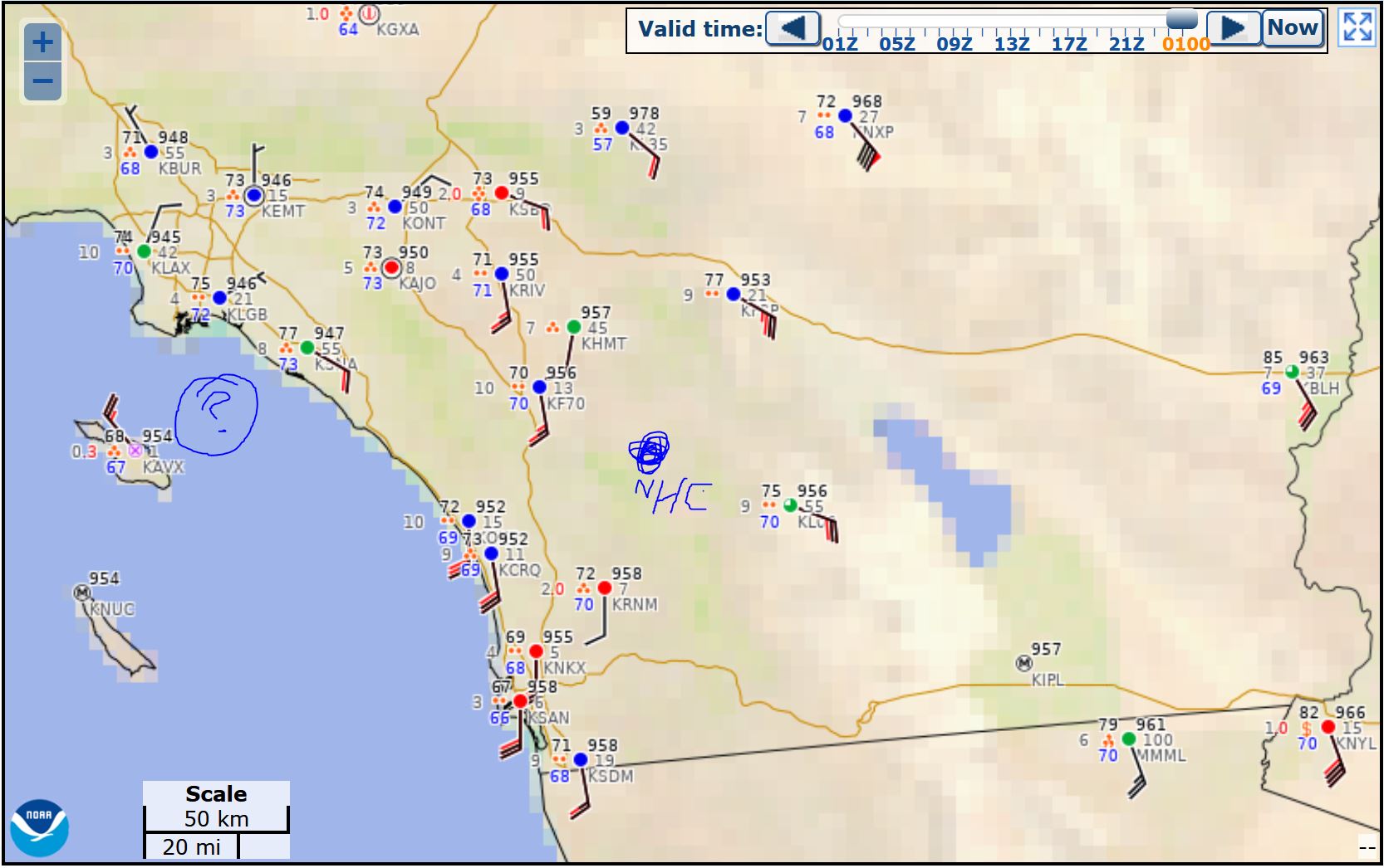
I plotted the NHC 00Z position on the obs map. No way there's an LLC there. I do see a low offshore south of Long Beach.
0 likes
Who is online
Users browsing this forum: No registered users and 12 guests