WPAC: DORA - Post-Tropical - Discussion

Moderator: S2k Moderators

Message
Author
User avatar
Ntxw
Storm2k Moderator
Storm2k Moderator
Posts: 22784
Joined: Wed Oct 21, 2009 6:34 pm
Location: DFW, Texas

Re: EPAC: DORA - Hurricane - Discussion

#341 Postby Ntxw » Sun Aug 06, 2023 3:47 pm

cycloneye wrote:
Ntxw wrote:
Yellow Evan wrote:
22.87 per a friend’s code. CSU doesn’t take into account overrides.


You're right! I created a spreadsheet to track all of the systems some years ago and it's 22.87 using operational history. I didn't realize CSU didn't account for that. If it holds 120kts next advisory would be 24.31.


Is there a link to that? I want to put the right numbers on the ACE Thread.


It's a personal spreadsheet. But you can add the 1.47 units difference from CSU. 22.87 for Dora, 49.31 for EPAC with Eugene's 18z 60kts 1.34.
1 likes   
The above post and any post by Ntxw is NOT an official forecast and should not be used as such. It is just the opinion of the poster and may or may not be backed by sound meteorological data. It is NOT endorsed by any professional institution including Storm2k. For official information, please refer to NWS products.

  Help support Storm2K!
Help Support Storm2K

User avatar
Ntxw
Storm2k Moderator
Storm2k Moderator
Posts: 22784
Joined: Wed Oct 21, 2009 6:34 pm
Location: DFW, Texas

Re: EPAC: DORA - Hurricane - Discussion

#342 Postby Ntxw » Sun Aug 06, 2023 4:15 pm

With the current official forecast she could potentially yield 15-20 more units. That puts us 40-45 total, but given she has beaten the forecast several times, I'll make a guess she goes 50+. The only deterrent from 50-60 units is the relative fast forward speed.

Image
3 likes   
The above post and any post by Ntxw is NOT an official forecast and should not be used as such. It is just the opinion of the poster and may or may not be backed by sound meteorological data. It is NOT endorsed by any professional institution including Storm2k. For official information, please refer to NWS products.


  Help support Storm2K!

Help Support Storm2K


Sciencerocks
Category 5
Category 5
Posts: 9155
Age: 39
Joined: Thu Jul 06, 2017 1:51 am

Re: EPAC: DORA - Hurricane - Discussion

#343 Postby Sciencerocks » Sun Aug 06, 2023 4:28 pm

This thing looks as strong as Dorian. What exactly would it take for this to receive an high enough estimate for the central Pacific hurricane center to go 5?
1 likes   

User avatar
cycloneye
Admin
Admin
Posts: 145295
Age: 68
Joined: Thu Oct 10, 2002 10:54 am
Location: San Juan, Puerto Rico

Re: EPAC: DORA - Hurricane - Discussion

#344 Postby cycloneye » Sun Aug 06, 2023 4:33 pm

Sciencerocks wrote:This thing looks as strong as Dorian. What exactly would it take for this to receive an high enough estimate for the central Pacific hurricane center to go 5?


The TC Post-Season Report will take a looong time to be released and there is a chance that it may be upgraded to 5.
2 likes   
Visit the Caribbean-Central America Weather Thread where you can find at first post web cams,radars
and observations from Caribbean basin members Click Here

Astromanía
Category 2
Category 2
Posts: 779
Age: 26
Joined: Sat Aug 25, 2018 10:34 pm
Location: Monterrey, N.L, México

Re: EPAC: DORA - Hurricane - Discussion

#345 Postby Astromanía » Sun Aug 06, 2023 4:35 pm

Sciencerocks wrote:This thing looks as strong as Dorian. What exactly would it take for this to receive an high enough estimate for the central Pacific hurricane center to go 5?

Recon, for it's size dvorak don't support a cat 5
1 likes   

User avatar
Yellow Evan
Professional-Met
Professional-Met
Posts: 16143
Age: 27
Joined: Fri Jul 15, 2011 12:48 pm
Location: Henderson, Nevada/Honolulu, HI
Contact:

Re: EPAC: DORA - Hurricane - Discussion

#346 Postby Yellow Evan » Sun Aug 06, 2023 5:15 pm

cycloneye wrote:
Sciencerocks wrote:This thing looks as strong as Dorian. What exactly would it take for this to receive an high enough estimate for the central Pacific hurricane center to go 5?


The TC Post-Season Report will take a looong time to be released and there is a chance that it may be upgraded to 5.


No chance without any evidence.
0 likes   

User avatar
Yellow Evan
Professional-Met
Professional-Met
Posts: 16143
Age: 27
Joined: Fri Jul 15, 2011 12:48 pm
Location: Henderson, Nevada/Honolulu, HI
Contact:

Re: EPAC: DORA - Hurricane - Discussion

#347 Postby Yellow Evan » Sun Aug 06, 2023 5:23 pm

Image

Back to T6.5.
1 likes   

User avatar
Yellow Evan
Professional-Met
Professional-Met
Posts: 16143
Age: 27
Joined: Fri Jul 15, 2011 12:48 pm
Location: Henderson, Nevada/Honolulu, HI
Contact:

Re: EPAC: DORA - Hurricane - Discussion

#348 Postby Yellow Evan » Sun Aug 06, 2023 5:23 pm

Image
4 likes   

User avatar
weeniepatrol
Category 5
Category 5
Posts: 1273
Joined: Sat Aug 22, 2020 5:30 pm
Location: WA State

Re: EPAC: DORA - Hurricane - Discussion

#349 Postby weeniepatrol » Sun Aug 06, 2023 5:29 pm

Dvorak-based
intensity estimates from PHFO, JTWC and SAB came in at 6.5,
continuing to support an initial intensity around 120 kt.


?????
1 likes   

User avatar
NDG
S2K Supporter
S2K Supporter
Posts: 15446
Joined: Sun Jul 09, 2006 10:14 pm
Location: Orlando, FL

Re: EPAC: DORA - Hurricane - Discussion

#350 Postby NDG » Sun Aug 06, 2023 5:29 pm

Dora is a beautiful hurricane.

Image
10 likes   

Sciencerocks
Category 5
Category 5
Posts: 9155
Age: 39
Joined: Thu Jul 06, 2017 1:51 am

Re: EPAC: DORA - Hurricane - Discussion

#351 Postby Sciencerocks » Sun Aug 06, 2023 6:15 pm

Image
1 likes   

User avatar
Blown Away
S2K Supporter
S2K Supporter
Posts: 10145
Joined: Wed May 26, 2004 6:17 am

Re: EPAC: DORA - Hurricane - Discussion

#352 Postby Blown Away » Sun Aug 06, 2023 7:14 pm

Could Dora maintain this intensity if at Hawaii’s latitude or does the slightly lower latitude allow systems to stay stronger??
0 likes   
Hurricane Eye Experience: David 79, Irene 99, Frances 04, Jeanne 04, Wilma 05... EYE COMING MY WAY IN 2024…
Hurricane Brush Experience: Andrew 92, Erin 95, Floyd 99, Matthew 16, Irma 17, Ian 22, Nicole 22…

User avatar
aspen
Category 5
Category 5
Posts: 8818
Joined: Sat Oct 12, 2019 7:10 pm
Location: Connecticut, USA

Re: EPAC: DORA - Hurricane - Discussion

#353 Postby aspen » Sun Aug 06, 2023 7:35 pm

Cloud tops look to be warming again. Will this be yet another temporary nighttime weakening trend and it’ll recover again tomorrow? Or is it finally weakening for real this time?
0 likes   
Irene '11 Sandy '12 Hermine '16 5/15/2018 Derecho Fay '20 Isaias '20 Elsa '21 Henri '21 Ida '21

I am only a meteorology enthusiast who knows a decent amount about tropical cyclones. Look to the professional mets, the NHC, or your local weather office for the best information.

869MB
S2K Supporter
S2K Supporter
Posts: 162
Joined: Thu Feb 14, 2019 9:49 pm
Location: Katy, TX

Re: EPAC: DORA - Hurricane - Discussion

#354 Postby 869MB » Sun Aug 06, 2023 7:49 pm

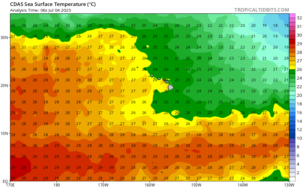
Blown Away wrote:Could Dora maintain this intensity if at Hawaii’s latitude or does the slightly lower latitude allow systems to stay stronger??


It would have been much more difficult, even as an annular hurricane, if Dora was cruising to the west along the 19.5 N to 20.5 N Latitude because the Sea Surface Temperatures are 2 to 4 Degrees cooler than the latitude Dora is currently at...


Image
2 likes   

User avatar
cycloneye
Admin
Admin
Posts: 145295
Age: 68
Joined: Thu Oct 10, 2002 10:54 am
Location: San Juan, Puerto Rico

Re: EPAC: DORA - Hurricane - Discussion

#355 Postby cycloneye » Sun Aug 06, 2023 7:55 pm

Steady at 120kt.

EP, 05, 2023080700, , BEST, 0, 127N, 1431W, 120, 948, HU
0 likes   
Visit the Caribbean-Central America Weather Thread where you can find at first post web cams,radars
and observations from Caribbean basin members Click Here

USTropics
Professional-Met
Professional-Met
Posts: 2650
Joined: Sun Aug 12, 2007 3:45 am
Location: Florida State University

Re: EPAC: DORA - Hurricane - Discussion

#356 Postby USTropics » Sun Aug 06, 2023 8:01 pm

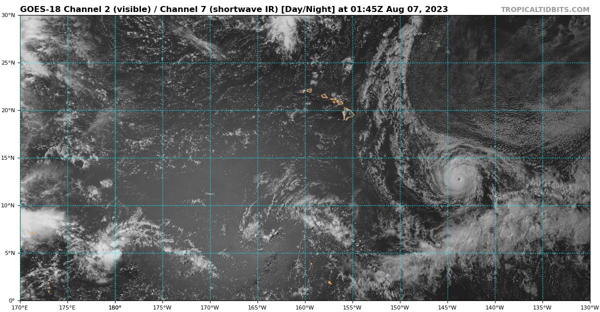
Blown Away wrote:Could Dora maintain this intensity if at Hawaii’s latitude or does the slightly lower latitude allow systems to stay stronger??


It's a pretty sharp gradient in terms of actual SSTs:
Image

You can see on the visible imagery, the presence of marine stratocumulus clouds just to the northeast of Dora is due to a much more stable air mass (in conjunction with a building high pressure area and less than ideal SSTs):
Image
4 likes   

Sciencerocks
Category 5
Category 5
Posts: 9155
Age: 39
Joined: Thu Jul 06, 2017 1:51 am

Re: EPAC: DORA - Hurricane - Discussion

#357 Postby Sciencerocks » Sun Aug 06, 2023 8:53 pm

Image
2 likes   

User avatar
Kingarabian
S2K Supporter
S2K Supporter
Posts: 15980
Joined: Sat Aug 08, 2009 3:06 am
Location: Honolulu, Hawaii

Re: EPAC: DORA - Hurricane - Discussion

#358 Postby Kingarabian » Sun Aug 06, 2023 9:08 pm

Dora is extremely impressive. But almost as impressive is that sprawling STR to its NE.

Image
2 likes   
RIP Kobe Bryant

User avatar
Kingarabian
S2K Supporter
S2K Supporter
Posts: 15980
Joined: Sat Aug 08, 2009 3:06 am
Location: Honolulu, Hawaii

Re: EPAC: DORA - Hurricane - Discussion

#359 Postby Kingarabian » Sun Aug 06, 2023 9:08 pm

USTropics wrote:
Blown Away wrote:Could Dora maintain this intensity if at Hawaii’s latitude or does the slightly lower latitude allow systems to stay stronger??


It's a pretty sharp gradient in terms of actual SSTs:
https://i.imgur.com/sWL0kfb.png

You can see on the visible imagery, the presence of marine stratocumulus clouds just to the northeast of Dora is due to a much more stable air mass (in conjunction with a building high pressure area and less than ideal SSTs):
https://i.imgur.com/ASwE5cc.png

Yeah not with this -PDO/-PMM combo.
0 likes   
RIP Kobe Bryant

User avatar
cycloneye
Admin
Admin
Posts: 145295
Age: 68
Joined: Thu Oct 10, 2002 10:54 am
Location: San Juan, Puerto Rico

Re: EPAC: DORA - Hurricane - Discussion

#360 Postby cycloneye » Sun Aug 06, 2023 10:02 pm

Hurricane Dora Discussion Number 27
NWS Central Pacific Hurricane Center Honolulu HI EP052023
500 PM HST Sun Aug 06 2023

Dora remains a well-organized, compact and symmetric hurricane,
moving west in the central Pacific. A blend of the subjective dvorak
estimates from PHFO, SAB and JTWC combined with the objective
estimates lends an initial intensity remaining at 120 kt. A partial
SAR pass this morning showed winds on the northeast side near 90 kt,
but may have missed some higher winds.

Additional fluctuations in intensity are expected over the next
several days as Dora continues a generally westward track along
27/28 C water, in a negligible wind shear environment. Satellite
data
shows significantly drier air several hundred miles north of Dora,
which if it is ingested into Dora. A slightly more defined
weakening trend is expected as some of that drier air is ingested
into Dora in a couple days. The intensity forecast continues to
follow the last few advisory packages for the first 36 hours, and
remains a little higher than the model consensus. Starting with 48
hours, the forecast intensity has been lowered a bit to keep it in
line with the overall pattern of the intensity models. As the
system moves into a more unfavorable shear environment beyond day
4, additional weakening is likely.

Very little change in the track forecast as models continue to be
very tightly clustered through the week. Dora will move to the west
along the southern edge of the ridge to the north, passing well
south of Hawaii over the next several days.

FORECAST POSITIONS AND MAX WINDS

INIT 07/0300Z 12.7N 144.0W 120 KT 140 MPH
12H 07/1200Z 12.5N 147.0W 115 KT 130 MPH
24H 08/0000Z 12.4N 150.8W 110 KT 125 MPH
36H 08/1200Z 12.2N 154.5W 105 KT 120 MPH
48H 09/0000Z 12.2N 158.4W 95 KT 110 MPH
60H 09/1200Z 12.4N 162.0W 90 KT 105 MPH
72H 10/0000Z 12.9N 165.6W 85 KT 100 MPH
96H 11/0000Z 13.9N 173.1W 75 KT 85 MPH
120H 12/0000Z 16.1N 179.7W 65 KT 75 MPH

$$
Forecaster Wroe/M Ballard
0 likes   
Visit the Caribbean-Central America Weather Thread where you can find at first post web cams,radars
and observations from Caribbean basin members Click Here


Return to “2023”

Who is online

Users browsing this forum: No registered users and 2 guests