Moderator: S2k Moderators


wxman57 wrote:Peak wind reported at the Guam airport was sustained wind 62 kts with a gust to 91 kts. This was not a supertyphoon as it passed. Likely a Cat 2 at that time. Maybe 100 kts. JTWC was likely overestimating winds. Considerable weakening occurred prior to passage.
xtyphooncyclonex wrote:wxman57 wrote:Peak wind reported at the Guam airport was sustained wind 62 kts with a gust to 91 kts. This was not a supertyphoon as it passed. Likely a Cat 2 at that time. Maybe 100 kts. JTWC was likely overestimating winds. Considerable weakening occurred prior to passage.
Nonprofessional observation here, I think a personal weather station in Hagatna recorded sustained winds of 157 km/h, several gusts in excess of 206 km/h (close to 105 kts) with the max gust of up to 240 km/h from 10-11 PM ChST. Shown in the previous page. Am not sure how reliable it is though. Did the Guam Airport continue reporting after the peak?


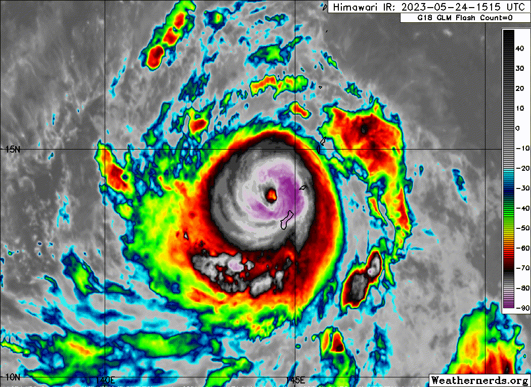
ScottNAtlanta wrote:The eye has really cleared out and become symmetric the last couple of frames on satellite. It seems this storm did that little island dance where it scoots around the north side of the island like you see sometimes with Hispaniola in the Atlantic.
doomhaMwx wrote:An elevated AWS at a research center in Yigo, Guam had a min station pressure of 27.949 inHg (946.46mb) at 20:05 CHST (10:05Z) as Mawar passed to the north. My personal estimate of the station elevation is about 140m ASL, resulting in ~962mb MSLP — so far the lowest I've seen in Guam.
https://i.imgur.com/spUcUFv.png
https://i.imgur.com/frj7uzm.png


ScottNAtlanta wrote:The eye has really cleared out and become symmetric the last couple of frames on satellite. It seems this storm did that little island dance where it scoots around the north side of the island like you see sometimes with Hispaniola in the Atlantic.


zzzh wrote:ERC is far from over per the microwave. Another case of IR deception.

Kingarabian wrote:ScottNAtlanta wrote:The eye has really cleared out and become symmetric the last couple of frames on satellite. It seems this storm did that little island dance where it scoots around the north side of the island like you see sometimes with Hispaniola in the Atlantic.
Possible but Guam is not as mountainous. But a great point as models don't seem to model this out properly. We do see this in Hawaii as well similar to Hispaniola.
canebeard wrote:Kingarabian wrote:ScottNAtlanta wrote:The eye has really cleared out and become symmetric the last couple of frames on satellite. It seems this storm did that little island dance where it scoots around the north side of the island like you see sometimes with Hispaniola in the Atlantic.
Possible but Guam is not as mountainous. But a great point as models don't seem to model this out properly. We do see this in Hawaii as well similar to Hispaniola.
I doubt Guam or Hawaii affects the path; more likely just fortuitous wobbles and/or erc at just the right time, changing the geometric center point temporarily. Hispanolia is another story. Guam has had direct hits on many occasions. When we went to Puerto Rico to chase Hugo in 1989, many of the locals in San Juan claimed the Yunque region east of them protected them from direct hits. Recent history has disproved that one.

Users browsing this forum: No registered users and 6 guests