ATL: TAMMY - Post-Tropical - Discussion
Moderator: S2k Moderators
-
ElectricStorm

- Category 5

- Posts: 5162
- Age: 25
- Joined: Tue Aug 13, 2019 11:23 pm
- Location: Norman, OK
Re: ATL: TAMMY - Hurricane - Discussion
991mb extrap from NOAA plane this pass
1 likes
B.S Meteorology, University of Oklahoma '25
Please refer to the NHC, NWS, or SPC for official information.
Please refer to the NHC, NWS, or SPC for official information.
-
tolakram
- Admin

- Posts: 20187
- Age: 62
- Joined: Sun Aug 27, 2006 8:23 pm
- Location: Florence, KY (name is Mark)
Re: ATL: TAMMY - Hurricane - Discussion

1 likes
M a r k
- - - - -
Join us in chat: Storm2K Chatroom Invite. Android and IOS apps also available.
The posts in this forum are NOT official forecasts and should not be used as such. Posts are NOT endorsed by any professional institution or STORM2K.org. For official information and forecasts, please refer to NHC and NWS products.
-
ElectricStorm
- Category 5
- Posts: 5162
- Age: 25
- Joined: Tue Aug 13, 2019 11:23 pm
- Location: Norman, OK
Re: ATL: TAMMY - Hurricane - Discussion
NOAA eye drop supports around 993-994mb, slightly up this pass
0 likes
B.S Meteorology, University of Oklahoma '25
Please refer to the NHC, NWS, or SPC for official information.
Please refer to the NHC, NWS, or SPC for official information.
-
galaxy401

- Category 5
- Posts: 2446
- Age: 30
- Joined: Sat Aug 25, 2012 9:04 pm
- Location: Casa Grande, Arizona
Re: ATL: TAMMY - Tropical Storm - Discussion
ElectricStorm wrote:All four hurricane models now have Tammy becoming a significant hurricane north of the islands, and 3 of the 4 have it becoming a hurricane within the next 12 hours before weakening near the islands before re-strengthening again. Not sure I completely buy the short term hurricane solution yet but given tonight's trends it's not impossible. Looks like it's pretty likely Tammy ends up becoming much stronger than I originally expected it to.
Those models nailed it.
8 likes
Got my eyes on moving right into Hurricane Alley: Florida.
-
Weatherwatcher2018
- Tropical Depression

- Posts: 82
- Joined: Wed Sep 26, 2018 4:30 pm


Re: ATL: TAMMY - Hurricane - Discussion
Weatherwatcher2018 wrote:What should we expect in Barbados
I'm no meteorologist but I think there's a good chance we'll get tropical-storm-force gusts at some point tonight.
1 likes
-
Sciencerocks
- Category 5
- Posts: 10194
- Age: 40
- Joined: Thu Jul 06, 2017 1:51 am
-
zal0phus

- Tropical Storm

- Posts: 201
- Age: 25
- Joined: Mon Jan 07, 2019 8:32 am
- Location: St. Louis
- Contact:
Re: ATL: TAMMY - Hurricane - Discussion
How strong could Tammy reasonably get? It already seems like it's overperforming
0 likes
Do not take anything I say seriously as a form of meteorological prediction. I am not a meteorologist; I don't think being in law school translates to any special knowledge. I am just a somewhat bullish amateur watcher.
-
tolakram
- Admin
- Posts: 20187
- Age: 62
- Joined: Sun Aug 27, 2006 8:23 pm
- Location: Florence, KY (name is Mark)
Re: ATL: TAMMY - Hurricane - Discussion

7 likes
M a r k
- - - - -
Join us in chat: Storm2K Chatroom Invite. Android and IOS apps also available.
The posts in this forum are NOT official forecasts and should not be used as such. Posts are NOT endorsed by any professional institution or STORM2K.org. For official information and forecasts, please refer to NHC and NWS products.
- - - - -
Join us in chat: Storm2K Chatroom Invite. Android and IOS apps also available.
The posts in this forum are NOT official forecasts and should not be used as such. Posts are NOT endorsed by any professional institution or STORM2K.org. For official information and forecasts, please refer to NHC and NWS products.
-
wxman57

- Moderator-Pro Met

- Posts: 23176
- Age: 68
- Joined: Sat Jun 21, 2003 8:06 pm
- Location: Houston, TX (southwest)
Re: ATL: TAMMY - Hurricane - Discussion
Weatherwatcher2018 wrote:What should we expect in Barbados
Winds are fairly light in Barbados, currently. However, there is a feeder band just south of Barbados that will be moving north into you this evening. That feeder band could produce a few inches of rain and some gusty wind.
1 likes
-
wxman57
- Moderator-Pro Met
- Posts: 23176
- Age: 68
- Joined: Sat Jun 21, 2003 8:06 pm
- Location: Houston, TX (southwest)
Re: ATL: TAMMY - Hurricane - Discussion
zal0phus wrote:How strong could Tammy reasonably get? It already seems like it's overperforming
Small storms, like Tammy, can fluctuate up and down in intensity quite rapidly. Probably Cat 1 north of the islands, maybe Cat 2 possible as it accelerates out to sea to the NE.
1 likes
-
HurricaneRyan
- Category 3

- Posts: 848
- Age: 32
- Joined: Sun Dec 05, 2010 3:05 pm
Re: ATL: TAMMY - Hurricane - Discussion
Definitely making up for Philippe
0 likes
Kay '22 Hilary '23
-
ThunderForce

- Tropical Storm
- Posts: 208
- Age: 26
- Joined: Tue Sep 27, 2022 6:20 pm
- Location: Calhoun County, Florida
Re: ATL: TAMMY - Hurricane - Discussion
Here's the latest 48 hour microwave imagery for Tammy. The slowdown and strengthening can be seen here, and both are pretty concerning. Hoping that the Leewards and Windwards won't get much damage from this.
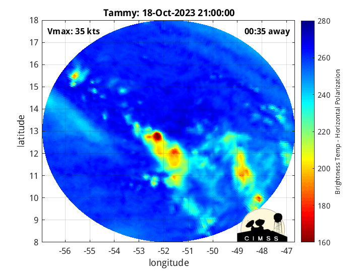
I've been getting these GIFs from this website. It's at the bottom of the page in "MIMIC-TC".
https://tropic.ssec.wisc.edu/real-time/summary/summary.20L_2023.html
I've been getting these GIFs from this website. It's at the bottom of the page in "MIMIC-TC".
https://tropic.ssec.wisc.edu/real-time/summary/summary.20L_2023.html
2 likes
Please refer to the NWS, NHC, SPC or a professional meteorologist for information and decision making during storms.

Re: ATL: TAMMY - Hurricane - Discussion
Sciencerocks wrote:https://twitter.com/philklotzbach/status/1715392299922755614
Tammy really had to work hard to get that record. Tomas became a hurricane at 60.1W on October 30th back in 2010.
Interesting that they are both the T-named storms, later in October, affecting the same general area.
6 likes
Solar Aquarian
Lunar Cancerian
 Sagittarian
Lunar Cancerian
-
Weatherwatcher2018
- Tropical Depression
- Posts: 82
- Joined: Wed Sep 26, 2018 4:30 pm
Re: ATL: TAMMY - Hurricane - Discussion
Unofficial reports saying the storm is wobbling wsw is this true ?
Also saying Barbados could have greater impacts as a result
Also saying Barbados could have greater impacts as a result
1 likes
-
wxman57
- Moderator-Pro Met
- Posts: 23176
- Age: 68
- Joined: Sat Jun 21, 2003 8:06 pm
- Location: Houston, TX (southwest)
Re: ATL: TAMMY - Hurricane - Discussion
Weatherwatcher2018 wrote:Unofficial reports saying the storm is wobbling wsw is this true ?
Also saying Barbados could have greater impacts as a result
Any impacts in Barbados will be from that feeder band south of the island, not from anything near Tammy's center. The center has already made its closest approach.
1 likes
-
wxman57
- Moderator-Pro Met
- Posts: 23176
- Age: 68
- Joined: Sat Jun 21, 2003 8:06 pm
- Location: Houston, TX (southwest)
Re: ATL: TAMMY - Hurricane - Discussion
I think Tammy is going through one of those fluctuations that is common with weak storms. Looks a lot less impressive on satellite now. Outflow boundaries shooting out from the central convection. Last recon pass indicated maybe 55-60 kt winds.
2 likes

Re: ATL: TAMMY - Hurricane - Discussion
zal0phus wrote:How strong could Tammy reasonably get? It already seems like it's overperforming
I think it’ll stay around 60-70 kt for the next 2-3 days. The hurricane models have been showing it developing a tight core like we saw verify today, but shear keeps it in check from bombing out. However, they’ve been showing shear lessening and a more persistent eyewall building once it gets north of the islands in 4-5 days, so maybe it could peak as a Cat 2-3 there.
1 likes
Irene '11 Sandy '12 Hermine '16 5/15/2018 Derecho Fay '20 Isaias '20 Elsa '21 Henri '21 Ida '21
I am only a meteorology enthusiast who knows a decent amount about tropical cyclones. Look to the professional mets, the NHC, or your local weather office for the best information.
I am only a meteorology enthusiast who knows a decent amount about tropical cyclones. Look to the professional mets, the NHC, or your local weather office for the best information.
-
cycloneye

- Admin
- Posts: 149800
- Age: 69
- Joined: Thu Oct 10, 2002 10:54 am
- Location: San Juan, Puerto Rico
Re: ATL: TAMMY - Hurricane - Discussion
For Msbee and Patti in St Marteen, there is now a Hurricane Warning.
Hurricane Tammy Tropical Cyclone Update
NWS National Hurricane Center Miami FL AL202023
215 PM AST Fri Oct 20 2023
The government of St. Maarten has issued a Hurricane Warning for
St. Maarten.
The government of France has issued a Hurricane Warning for St.
Martin and St. Barthelemy.
The government of Antigua has issued a Hurricane Warning for
Anguilla.
$$
Forecaster Brown
3 likes
Visit the Caribbean-Central America Weather Thread where you can find at first post web cams,radars
and observations from Caribbean basin members Click Here
and observations from Caribbean basin members Click Here
Who is online
Users browsing this forum: No registered users and 140 guests