
ATL: IDALIA - Models
Moderator: S2k Moderators

-
gatorcane

- S2K Supporter

- Posts: 23708
- Age: 48
- Joined: Sun Mar 13, 2005 3:54 pm
- Location: Boca Raton, FL
Re: ATL: INVEST 93L - Models
12Z Euro loop, Tampa area and West-Central Florida on the dirty side, landfall around Cedar Key / Big Bend:

1 likes

Re: ATL: INVEST 93L - Models
The reason the 12Z GFS is tracking further west and stronger is that the trough erodes and splits this run at about 90 hours. That (would mean) less shear and a dangerous storm at landfall.
You can see the trough at 90 hours here:

And at hour 96 you can see where the low has cut off and is rolling west into Mexico ventilating the system.

It is only one possible scenario but the surface low hasn't migrated north as fast as was first thought and is forming pretty far south just off Belize so I favor the slower forecast ATM. The weaker members of the ECM were probably responding to and being sheared by the trough earlier so hope for that to dig and prepare anyways.
You can see the trough at 90 hours here:
And at hour 96 you can see where the low has cut off and is rolling west into Mexico ventilating the system.
It is only one possible scenario but the surface low hasn't migrated north as fast as was first thought and is forming pretty far south just off Belize so I favor the slower forecast ATM. The weaker members of the ECM were probably responding to and being sheared by the trough earlier so hope for that to dig and prepare anyways.
1 likes
-
MississippiWx

- S2K Supporter
- Posts: 1720
- Joined: Sat Aug 14, 2010 1:44 pm
- Location: Hattiesburg, Mississippi
Re: ATL: INVEST 93L - Models
Gotta like the Euro's consistency. Hard to go against it.
2 likes
This post is not an official forecast and should not be used as such. It is just the opinion of MississippiWx and may or may not be backed by sound meteorological data. It is not endorsed by any professional institution including storm2k.org. For Official Information please refer to the NHC and NWS products.
-
chris_fit

- Category 5

- Posts: 3261
- Age: 43
- Joined: Wed Sep 10, 2003 11:58 pm
- Location: Tampa Bay Area, FL
Re: ATL: INVEST 93L - Models
Another classic GFS vs EURO.
GFS = W
EURO = E
(which is weird in itself, as the opposite are typically their biases. They were like this with Ian too.)
So far, Euro is 1-0 in actually forecasting this to develop (assuming it actually does now.)
GFS = W
EURO = E
(which is weird in itself, as the opposite are typically their biases. They were like this with Ian too.)
So far, Euro is 1-0 in actually forecasting this to develop (assuming it actually does now.)
1 likes
Re: ATL: INVEST 93L - Models
12z UKMet (New Port RIchey to Hernando Beach)


Last edited by BobHarlem on Fri Aug 25, 2023 1:45 pm, edited 3 times in total.
1 likes
-
wxman57

- Moderator-Pro Met

- Posts: 23172
- Age: 68
- Joined: Sat Jun 21, 2003 8:06 pm
- Location: Houston, TX (southwest)
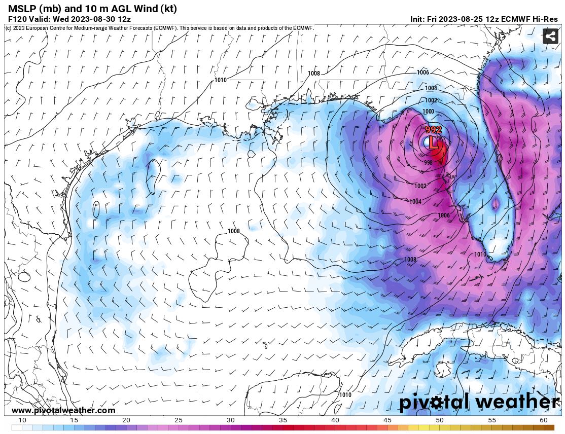
Re: ATL: INVEST 93L - Models
12Z EC track into northern Peninsula as 992mb TS. Could move inland farther NW. EC is the farthest east.
0 likes
-
Stormlover1970
- Tropical Low

- Posts: 32
- Age: 56
- Joined: Sun May 22, 2022 9:26 am
- Location: New Port Richey, Florida
Re: ATL: INVEST 93L - Models
its very hard for my area to get hit from the gulf in New port richey either way still on the dirty sidewxman57 wrote:12Z EC track into northern Peninsula as 992mb TS. Could move inland farther NW. EC is the farthest east.
http://wxman57.com/images/12ZEC.JPG
0 likes
-
lsuhurricane
- Category 1

- Posts: 270
- Joined: Tue Aug 15, 2017 2:53 pm

Re: ATL: INVEST 93L - Models
lsuhurricane wrote:https://i.ibb.co/G5tDQ1F/14-km-EPS-Global-Cyclones-Gulf-of-Mexico-Ens-MSLP-Spaghettios.gif
Slightly west compared to prior runs, but splitting hairs
Those are too far West. Looks like most have it at 87 while NHC has it around 85.5
Last edited by caneman on Fri Aug 25, 2023 3:39 pm, edited 1 time in total.
0 likes
-
hurricane2025
- Category 1
- Posts: 254
- Joined: Thu Apr 08, 2021 10:36 am
-
PavelGaborik10
- Category 1
- Posts: 472
- Joined: Tue Sep 04, 2018 3:23 pm

Re: ATL: INVEST 93L - Models
Remember how stubbornly far west GFS was with IAN less than 48 hrs to landfall. Had it consistently hitting the FL panhandle. I will never forget how that skewed the consensus track further north along the FL west coast. Ukmet had it ultimately nailed but Euro wasn't far off with sarasota-Ft Myers landfall. I have become deeply skeptical of GFS based on that history.
2 likes

Re: ATL: INVEST 93L - Models
This is the set up when a storm moves parallel to the southerly windshear which they strengthen more than forecasted. 36-48 hrs over the GOM is more than enough time to strengthen into at least a Cat 1.
12z Euro forecasts less than 10 knots of windshear over it.

12z Euro forecasts less than 10 knots of windshear over it.
2 likes

-
tolakram
- Admin

- Posts: 20178
- Age: 62
- Joined: Sun Aug 27, 2006 8:23 pm
- Location: Florence, KY (name is Mark)
Re: ATL: INVEST 93L - Models
Euro landfall. I'll also update my 12Z post previously with this frame.

0 likes
M a r k
- - - - -
Join us in chat: Storm2K Chatroom Invite. Android and IOS apps also available.
The posts in this forum are NOT official forecasts and should not be used as such. Posts are NOT endorsed by any professional institution or STORM2K.org. For official information and forecasts, please refer to NHC and NWS products.
-
Spacecoast

- Category 2

- Posts: 773
- Joined: Thu Aug 31, 2017 2:03 pm

-
gatorcane
- S2K Supporter
- Posts: 23708
- Age: 48
- Joined: Sun Mar 13, 2005 3:54 pm
- Location: Boca Raton, FL
Re: ATL: INVEST 93L - Models
18Z Happy Hour GFS starts in 10 min. Should be interesting what it outputs this time considering 24 hours ago it had nothing and the 12Z had a CAT 2. Perhaps it is now overdoing things but we shall see.
Last edited by gatorcane on Fri Aug 25, 2023 4:24 pm, edited 1 time in total.
0 likes
Who is online
Users browsing this forum: No registered users and 36 guests