
ATL: JOSE - Remnants - Discussion
Moderator: S2k Moderators
Re: ATL: INVEST 92L - Discussion
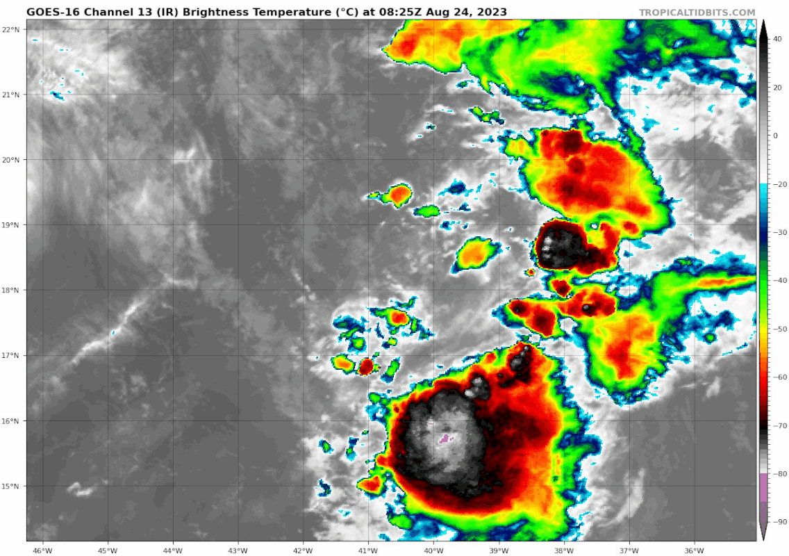
92L has done a good job maintaining convection:
0 likes
TC naming lists: retirements and intensity
Most aggressive Advisory #1's in North Atlantic (cr. kevin for starting the list)
Most aggressive Advisory #1's in North Atlantic (cr. kevin for starting the list)
-
Iceresistance

- Category 5

- Posts: 9579
- Age: 22
- Joined: Sat Oct 10, 2020 9:45 am
- Location: Tecumseh, OK/Norman, OK
Re: ATL: INVEST 92L - Discussion
2 likes
Bill 2015 & Beta 2020
Winter 2020-2021
All observations are in Tecumseh, OK unless otherwise noted.
Winter posts are focused mainly for Oklahoma & Texas.
Take any of my forecasts with a grain of salt, refer to the NWS, SPC, and NHC for official information
Never say Never with weather! Because ANYTHING is possible!
Winter 2020-2021
All observations are in Tecumseh, OK unless otherwise noted.
Winter posts are focused mainly for Oklahoma & Texas.
Take any of my forecasts with a grain of salt, refer to the NWS, SPC, and NHC for official information
Never say Never with weather! Because ANYTHING is possible!
-
Extratropical94

- Professional-Met

- Posts: 3545
- Age: 31
- Joined: Wed Oct 20, 2010 6:36 am
- Location: Hamburg, Germany
- Contact:
Re: ATL: INVEST 92L - Discussion
Central Tropical Atlantic (AL92):
Disorganized showers and thunderstorms continue in association with
an area of low pressure located midway between the Cabo Verde
Islands and the northern Lesser Antilles. While environmental
conditions are marginal for additional development, they could
become more conducive in a few days. A tropical depression could
form by early next week while the system moves west-northwestward to
northwestward into the central subtropical Atlantic.
* Formation chance through 48 hours...low...20 percent.
* Formation chance through 7 days...medium...50 percent.
0 likes
54° 11' 59'' N, 9° 9' 20'' E
Boomer Sooner!
Go Broncos! Go Cards!
Clinching counties, one at a time: https://mob-rule.com/user-gifs/USA/xtrp94.gif
- Daniel
Boomer Sooner!
Go Broncos! Go Cards!
Clinching counties, one at a time: https://mob-rule.com/user-gifs/USA/xtrp94.gif
- Daniel
-
Sciencerocks
- Category 5
- Posts: 10181
- Age: 40
- Joined: Thu Jul 06, 2017 1:51 am

-
cycloneye

- Admin

- Posts: 149275
- Age: 69
- Joined: Thu Oct 10, 2002 10:54 am
- Location: San Juan, Puerto Rico
Re: ATL: INVEST 92L - Discussion
Central Tropical Atlantic (AL92):
Disorganized showers and thunderstorms continue in association with
an area of low pressure located midway between the Cabo Verde
Islands and the northern Lesser Antilles. Environmental conditions
could become more conducive for development in a few days, and a
tropical depression could form by early next week while the system
moves generally northwestward toward the central subtropical
Atlantic.
* Formation chance through 48 hours...low...20 percent.
* Formation chance through 7 days...medium...50 percent.
0 likes
Visit the Caribbean-Central America Weather Thread where you can find at first post web cams,radars
and observations from Caribbean basin members Click Here
and observations from Caribbean basin members Click Here
-
Sciencerocks
- Category 5
- Posts: 10181
- Age: 40
- Joined: Thu Jul 06, 2017 1:51 am

-
cycloneye
- Admin
- Posts: 149275
- Age: 69
- Joined: Thu Oct 10, 2002 10:54 am
- Location: San Juan, Puerto Rico
Re: ATL: INVEST 92L - Discussion
AL, 92, 2023082512, , BEST, 0, 198N, 445W, 25, 1009, DB
0 likes
Visit the Caribbean-Central America Weather Thread where you can find at first post web cams,radars
and observations from Caribbean basin members Click Here
and observations from Caribbean basin members Click Here
-
Sciencerocks
- Category 5
- Posts: 10181
- Age: 40
- Joined: Thu Jul 06, 2017 1:51 am

-
ScottNAtlanta

- Category 5
- Posts: 2535
- Joined: Sat May 25, 2013 3:11 pm
- Location: Atlanta, GA
Re: ATL: INVEST 92L - Discussion
Check out the energy wave that comes out of 92L. Looks like the energy wave of a volcano

0 likes
The posts in this forum are NOT official forecast and should not be used as such. They are just the opinion of the poster and may or may not be backed by sound meteorological data. They are NOT endorsed by any professional institution or storm2k.org. For official information, please refer to the NHC and NWS products.
-
cycloneye
- Admin
- Posts: 149275
- Age: 69
- Joined: Thu Oct 10, 2002 10:54 am
- Location: San Juan, Puerto Rico
Re: ATL: INVEST 92L - Discussion
Central Tropical Atlantic (AL92):
Disorganized showers and thunderstorms continue in association with
an area of low pressure located about midway between the Cabo Verde
Islands and the northern Leeward Islands. Environmental conditions
could become more conducive for development over the weekend, and a
tropical depression could form by early next week while the system
moves generally northwestward toward the central subtropical
Atlantic.
* Formation chance through 48 hours...low...20 percent.
* Formation chance through 7 days...medium...50 percent.
0 likes
Visit the Caribbean-Central America Weather Thread where you can find at first post web cams,radars
and observations from Caribbean basin members Click Here
and observations from Caribbean basin members Click Here
-
cycloneye
- Admin
- Posts: 149275
- Age: 69
- Joined: Thu Oct 10, 2002 10:54 am
- Location: San Juan, Puerto Rico
Re: ATL: INVEST 92L - Discussion
Central Tropical Atlantic (AL92):
Disorganized showers and thunderstorms continue in association with
a broad area of low pressure located several hundred miles
east-northeast of the northern Leeward Islands. Environmental
conditions could become more conducive for development over the
weekend, and a tropical depression could form early next week while
the system moves generally northwestward over the central
subtropical Atlantic.
* Formation chance through 48 hours...low...20 percent.
* Formation chance through 7 days...medium...40 percent.
0 likes
Visit the Caribbean-Central America Weather Thread where you can find at first post web cams,radars
and observations from Caribbean basin members Click Here
and observations from Caribbean basin members Click Here
-
Extratropical94
- Professional-Met
- Posts: 3545
- Age: 31
- Joined: Wed Oct 20, 2010 6:36 am
- Location: Hamburg, Germany
- Contact:
Re: ATL: INVEST 92L - Discussion
Central Tropical Atlantic (AL92):
Disorganized showers and thunderstorms continue in association with
a broad area of low pressure located several hundred miles
east-northeast of the northern Leeward Islands. Environmental
conditions could become more conducive for development over the
weekend, and a tropical depression could form early next week while
the system moves generally northwestward over the central
subtropical Atlantic.
* Formation chance through 48 hours...low...20 percent.
* Formation chance through 7 days...medium...40 percent.
0 likes
54° 11' 59'' N, 9° 9' 20'' E
Boomer Sooner!
Go Broncos! Go Cards!
Clinching counties, one at a time: https://mob-rule.com/user-gifs/USA/xtrp94.gif
- Daniel
Boomer Sooner!
Go Broncos! Go Cards!
Clinching counties, one at a time: https://mob-rule.com/user-gifs/USA/xtrp94.gif
- Daniel
-
cycloneye
- Admin
- Posts: 149275
- Age: 69
- Joined: Thu Oct 10, 2002 10:54 am
- Location: San Juan, Puerto Rico
Re: ATL: INVEST 92L - Discussion
AL, 92, 2023082612, , BEST, 0, 240N, 490W, 25, 1011, DB
0 likes
Visit the Caribbean-Central America Weather Thread where you can find at first post web cams,radars
and observations from Caribbean basin members Click Here
and observations from Caribbean basin members Click Here
-
Sciencerocks
- Category 5
- Posts: 10181
- Age: 40
- Joined: Thu Jul 06, 2017 1:51 am
Re: ATL: INVEST 92L - Discussion

Looking better organized with a elongated LLC becoming better defined.
1 likes
-
cycloneye
- Admin
- Posts: 149275
- Age: 69
- Joined: Thu Oct 10, 2002 10:54 am
- Location: San Juan, Puerto Rico
Re: ATL: INVEST 92L - Discussion
Bye.
Central Tropical Atlantic (AL92):
Shower and thunderstorm activity continues to diminish near a
trough of low pressure located about 1000 miles east-southeast of
Bermuda. Development of this system is no longer expected, as it
moves slowly northwestward to north-northwestward over the central
subtropical Atlantic over the next couple of days.
* Formation chance through 48 hours...low...near 0 percent.
* Formation chance through 7 days...low...near 0 percent.
0 likes
Visit the Caribbean-Central America Weather Thread where you can find at first post web cams,radars
and observations from Caribbean basin members Click Here
and observations from Caribbean basin members Click Here
-
Extratropical94
- Professional-Met
- Posts: 3545
- Age: 31
- Joined: Wed Oct 20, 2010 6:36 am
- Location: Hamburg, Germany
- Contact:
Re: ATL: INVEST 92L - Discussion
AL, 92, 2023082900, , BEST, 0, 278N, 517W, 30, 1016, LO
0 likes
54° 11' 59'' N, 9° 9' 20'' E
Boomer Sooner!
Go Broncos! Go Cards!
Clinching counties, one at a time: https://mob-rule.com/user-gifs/USA/xtrp94.gif
- Daniel
Boomer Sooner!
Go Broncos! Go Cards!
Clinching counties, one at a time: https://mob-rule.com/user-gifs/USA/xtrp94.gif
- Daniel
-
Extratropical94
- Professional-Met
- Posts: 3545
- Age: 31
- Joined: Wed Oct 20, 2010 6:36 am
- Location: Hamburg, Germany
- Contact:
Re: ATL: INVEST 92L - Discussion
Central Subtropical Atlantic (AL92):
Showers and thunderstorms have recently become more concentrated
with an area of low pressure located about 1000 miles northeast of
the northern Leeward Islands. Recent satellite wind data also
indicates that its circulation has become better defined.
Environmental conditions appear favorable for additional development
over the next couple of days before becoming more unfavorable by the
latter part of this week as the system drifts slowly over the
central subtropical Atlantic.
* Formation chance through 48 hours...low...30 percent.
* Formation chance through 7 days...low...30 percent.
0 likes
54° 11' 59'' N, 9° 9' 20'' E
Boomer Sooner!
Go Broncos! Go Cards!
Clinching counties, one at a time: https://mob-rule.com/user-gifs/USA/xtrp94.gif
- Daniel
Boomer Sooner!
Go Broncos! Go Cards!
Clinching counties, one at a time: https://mob-rule.com/user-gifs/USA/xtrp94.gif
- Daniel

Re: ATL: INVEST 92L - Discussion
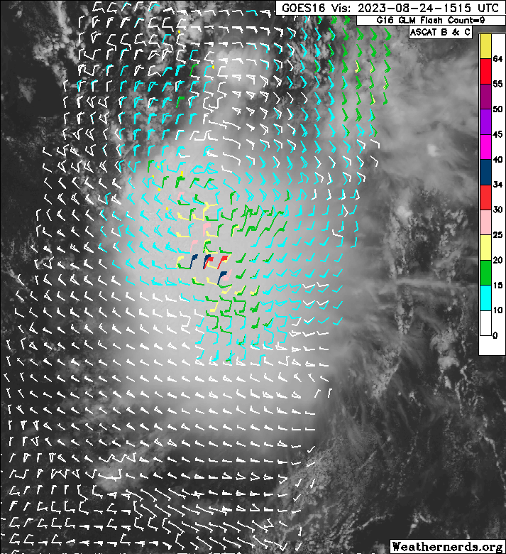
What the heck, this is close to TS strength with a slightly elongated (but defined) center... can even argue it has TS strength gales with the multiple 30kt+ barbs for a tiny system due to undersampling. This just had to wait for 10L to take the cursed I name, didn't it...

3 likes
-
cycloneye
- Admin
- Posts: 149275
- Age: 69
- Joined: Thu Oct 10, 2002 10:54 am
- Location: San Juan, Puerto Rico
Re: ATL: INVEST 92L - Discussion

1 likes
Visit the Caribbean-Central America Weather Thread where you can find at first post web cams,radars
and observations from Caribbean basin members Click Here
and observations from Caribbean basin members Click Here
Who is online
Users browsing this forum: No registered users and 113 guests