ATL: DON - Post-Tropical - Discussion

Moderator: S2k Moderators

Message
Author
User avatar
cycloneye
Admin
Admin
Posts: 139593
Age: 67
Joined: Thu Oct 10, 2002 10:54 am
Location: San Juan, Puerto Rico

Re: ATL: INVEST 94L - Discussion

#21 Postby cycloneye » Thu Jul 13, 2023 12:38 pm

Tropical Weather Outlook
NWS National Hurricane Center Miami FL
200 PM EDT Thu Jul 13 2023

For the North Atlantic...Caribbean Sea and the Gulf of Mexico:

Central Atlantic (AL94):
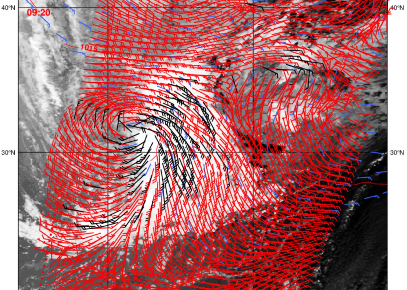
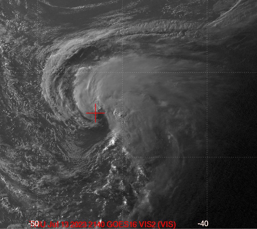
An area of low pressure located about 900 miles east of Bermuda is
producing gale-force winds and disorganized showers and
thunderstorms. However, recent satellite imagery indicates that the
system does not have a well-defined low-level center. Environmental
conditions are forecast to be somewhat conducive for this system to
become a subtropical storm during the next day or so, as it meanders
over the central Atlantic. By the weekend, the low should turn
northward bringing the system over cooler waters, potentially
limiting additional development. Additional information on this
system, including gale warnings, can be found in High Seas
Forecasts, issued by the National Weather Service.
* Formation chance through 48 hours...medium...60 percent.
* Formation chance through 7 days...medium...60 percent.

&&
High Seas Forecasts issued by the National Weather Service
can be found under AWIPS header NFDHSFAT1, WMO header FZNT01
KWBC, and online at ocean.weather.gov/shtml/NFDHSFAT1.php

$$
Forecaster Kelly/Berg
0 likes   
Visit the Caribbean-Central America Weather Thread where you can find at first post web cams,radars
and observations from Caribbean basin members Click Here

User avatar
wxman57
Moderator-Pro Met
Moderator-Pro Met
Posts: 22506
Age: 66
Joined: Sat Jun 21, 2003 8:06 pm
Location: Houston, TX (southwest)

Re: ATL: INVEST 94L - Discussion

#22 Postby wxman57 » Thu Jul 13, 2023 12:45 pm

Nope, no advisory from NHC this pm. Doesn't have a well-defined LLC? Scatterometer data indicated a quite well-defined LLC earlier this morning with at least 35 kt winds:

I don't know, but I think I can just BARELY make out a circulation here:
Image
4 likes   

User avatar
tiger_deF
Category 1
Category 1
Posts: 440
Age: 23
Joined: Tue Sep 27, 2016 11:47 am

Re: ATL: INVEST 94L - Discussion

#23 Postby tiger_deF » Thu Jul 13, 2023 1:43 pm

It's interesting that the GFS is predicting a westward motion of 94L in a few days at such a latitude. I'm curious, has a storm ever impacted Atlantic Canada or New England coming in from the *East*?
Last edited by tiger_deF on Thu Jul 13, 2023 2:45 pm, edited 1 time in total.
0 likes   

User avatar
wxman57
Moderator-Pro Met
Moderator-Pro Met
Posts: 22506
Age: 66
Joined: Sat Jun 21, 2003 8:06 pm
Location: Houston, TX (southwest)

Re: ATL: INVEST 94L - Discussion

#24 Postby wxman57 » Thu Jul 13, 2023 2:02 pm

tiger_deF wrote:It's interesting that the GFS is predicting a westward motion of 94L in a few days at such a latitude. I'm curious, has a storm ever impacted Atlantic Canada or New England coming in from the west?


I assume you meant from the east and not west? That would be unusual, but this one should be a total fish storm.
0 likes   

Sciencerocks
Category 5
Category 5
Posts: 7300
Age: 38
Joined: Thu Jul 06, 2017 1:51 am

Re: ATL: INVEST 94L - Discussion

#25 Postby Sciencerocks » Thu Jul 13, 2023 3:05 pm

I'd say that this is now deserving of an upgrade. ;)
Image
0 likes   

User avatar
MGC
S2K Supporter
S2K Supporter
Posts: 5796
Joined: Sun Mar 23, 2003 9:05 pm
Location: Pass Christian MS, or what is left.

Re: ATL: INVEST 94L - Discussion

#26 Postby MGC » Thu Jul 13, 2023 3:06 pm

Train wreck....unless it reorganizes closer to the convection to its east. Formation odds should start to decrease soon......MGC
0 likes   

User avatar
Teban54
Category 5
Category 5
Posts: 1983
Joined: Sat May 19, 2018 1:19 pm

Re: ATL: INVEST 94L - Discussion

#27 Postby Teban54 » Thu Jul 13, 2023 3:06 pm

Sciencerocks wrote:I'd say that this is now deserving of an upgrade. ;)
https://imagizer.imageshack.com/img924/3260/pNAnu6.gif

MGC wrote:Train wreck....unless it reorganizes closer to the convection to its east. Formation odds should start to decrease soon......MGC

The duality of S2K strikes again :lol:
9 likes   

User avatar
JetFuel_SE
Category 1
Category 1
Posts: 279
Age: 24
Joined: Thu Apr 30, 2020 3:57 pm

Re: ATL: INVEST 94L - Discussion

#28 Postby JetFuel_SE » Thu Jul 13, 2023 3:40 pm

MGC wrote:Train wreck....unless it reorganizes closer to the convection to its east. Formation odds should start to decrease soon......MGC

What are you talking about? It's basically already there, just needs to improve its circulation a bit.
Also the chances would only decrease in the short term, as this'll have another shot when it dips back south.
2 likes   

User avatar
aspen
Category 5
Category 5
Posts: 8061
Joined: Sat Oct 12, 2019 7:10 pm
Location: Connecticut, USA

Re: ATL: INVEST 94L - Discussion

#29 Postby aspen » Thu Jul 13, 2023 4:41 pm

Getting close. We could have STS or TS Don by tomorrow morning. I hope this isn’t another STS-1 situation where it’s clearly a name-worthy system but isn’t upgraded.
3 likes   
Irene '11 Sandy '12 Hermine '16 5/15/2018 Derecho Fay '20 Isaias '20 Elsa '21 Henri '21 Ida '21

I am only a meteorology enthusiast who knows a decent amount about tropical cyclones. Look to the professional mets, the NHC, or your local weather office for the best information.

User avatar
Hammy
Category 5
Category 5
Posts: 5594
Age: 40
Joined: Fri May 25, 2012 5:25 pm
Contact:

Re: ATL: INVEST 94L - Discussion

#30 Postby Hammy » Thu Jul 13, 2023 4:44 pm

MGC wrote:Train wreck....unless it reorganizes closer to the convection to its east. Formation odds should start to decrease soon......MGC


Both the models and real time satellite show increased organization, and that will likely continue for at least the next 2-3 days. This has been organizing quite rapidly over the last several hours.
2 likes   
The above post is not official and should not be used as such. It is the opinion of the poster and may or may not be backed by sound meteorological data. It is not endorsed by any professional institution or storm2k.org. For official information, please refer to the NHC and NWS products.

LarryWx
Category 5
Category 5
Posts: 5788
Joined: Sun Sep 07, 2003 2:04 pm
Location: GA

Re: ATL: INVEST 94L - Discussion

#31 Postby LarryWx » Thu Jul 13, 2023 4:47 pm

So, it appears that Don will turn out to be still another named system in the subtropics initially underestimated for potential. It wasn't even mentioned in the 7 day TWO til 4.5 days ago.
0 likes   
Personal Forecast Disclaimer:
The posts in this forum are NOT official forecasts and should not be used as such. They are just the opinion of the poster and may or may not be backed by sound meteorological data. They are NOT endorsed by any professional institution or storm2k.org. For official information, please refer to the NHC and NWS products.

User avatar
cycloneye
Admin
Admin
Posts: 139593
Age: 67
Joined: Thu Oct 10, 2002 10:54 am
Location: San Juan, Puerto Rico

Re: ATL: INVEST 94L - Discussion

#32 Postby cycloneye » Thu Jul 13, 2023 4:53 pm

0 likes   
Visit the Caribbean-Central America Weather Thread where you can find at first post web cams,radars
and observations from Caribbean basin members Click Here

User avatar
johngaltfla
Category 5
Category 5
Posts: 1939
Joined: Sun Jul 10, 2005 9:17 pm
Location: Sarasota County, FL
Contact:

Re: ATL: INVEST 94L - Discussion

#33 Postby johngaltfla » Thu Jul 13, 2023 5:48 pm

Another poor excuse of a storm from the NHC to deny me the S2K Hurricane Prediction Title. Bleh. :grr:
0 likes   

User avatar
wxman57
Moderator-Pro Met
Moderator-Pro Met
Posts: 22506
Age: 66
Joined: Sat Jun 21, 2003 8:06 pm
Location: Houston, TX (southwest)

Re: ATL: INVEST 94L - Discussion

#34 Postby wxman57 » Thu Jul 13, 2023 6:19 pm

MGC wrote:Train wreck....unless it reorganizes closer to the convection to its east. Formation odds should start to decrease soon......MGC


I think it has reorganized near the convection. Appears to qualify for at least a subtropical storm now. Center is where I put the crosshairs.

Image
3 likes   

User avatar
Hurricane2022
Category 4
Category 4
Posts: 957
Joined: Tue Aug 23, 2022 11:38 pm
Location: Araçatuba, Brazil

Re: ATL: INVEST 94L - Discussion

#35 Postby Hurricane2022 » Thu Jul 13, 2023 6:30 pm

Tropical Weather Outlook
NWS National Hurricane Center Miami FL
800 PM EDT Thu Jul 13 2023

For the North Atlantic...Caribbean Sea and the Gulf of Mexico:

1. Central Atlantic (AL94):
An area of low pressure located about 1000 miles west-southwest of
the Azores has become more organized today, with increased
thunderstorm activity near a better-defined low-level center, along
with gale-force winds. Although the environment is only marginally
conducive, this system will likely become a subtropical storm during
the next day or so as it meanders over the central Atlantic. By the
weekend, the low should turn northward, bringing the system over
cooler waters and potentially limiting further development.
Additional information on this system, including gale warnings, can
be found in High Seas Forecasts, issued by the National Weather
Service.
* Formation chance through 48 hours...high...70 percent.
* Formation chance through 7
days...high...70 percent.

High Seas Forecasts issued by the National Weather Service
can be found under AWIPS header NFDHSFAT1, WMO header FZNT01
KWBC, and online at ocean.weather.gov/shtml/NFDHSFAT1.php

Forecaster Blake

Image
0 likes   
Sorry for the bad English sometimes...!
For reliable and detailed information for any meteorological phenomenon, please consult the National Hurricane Center, Joint Typhoon Warning Center , or your local Meteo Center.

--------

Una cvm Christo, pro Christo, et in Christo. Sit nomen Domini benedictvm.

User avatar
Category5Kaiju
Category 5
Category 5
Posts: 3438
Age: 22
Joined: Thu Dec 24, 2020 12:45 pm
Location: Seattle

Re: ATL: INVEST 94L - Discussion

#36 Postby Category5Kaiju » Thu Jul 13, 2023 7:20 pm

MGC wrote:Train wreck....unless it reorganizes closer to the convection to its east. Formation odds should start to decrease soon......MGC


Well it’s now red, so…
1 likes   
Unless explicitly stated, all information covered in my posts is based on my opinions and observations. Please refer to a professional meteorologist or an accredited weather research agency otherwise, especially if serious decisions must be made in the event of a potentially life-threatening tropical storm or hurricane.

User avatar
cycloneye
Admin
Admin
Posts: 139593
Age: 67
Joined: Thu Oct 10, 2002 10:54 am
Location: San Juan, Puerto Rico

Re: ATL: INVEST 94L - Discussion

#37 Postby cycloneye » Thu Jul 13, 2023 8:04 pm

45kt

AL, 94, 2023071400, , BEST, 0, 327N, 465W, 45, 1002, LO,
3 likes   
Visit the Caribbean-Central America Weather Thread where you can find at first post web cams,radars
and observations from Caribbean basin members Click Here

User avatar
Jr0d
S2K Supporter
S2K Supporter
Posts: 1177
Joined: Tue Aug 27, 2019 10:52 am
Location: Cayo Hueso

Re: ATL: INVEST 94L - Discussion

#38 Postby Jr0d » Thu Jul 13, 2023 8:41 pm

wxman57 wrote:
MGC wrote:Train wreck....unless it reorganizes closer to the convection to its east. Formation odds should start to decrease soon......MGC


I think it has reorganized near the convection. Appears to qualify for at least a subtropical storm now. Center is where I put the crosshairs.

http://wxman57.com/images/94La.JPG


I feel like the NHC likes to go in 10% increments on these systems that pose no threat to land..i wouldn't be surprised if the 2am update is at 80%, tomorrows 8am at 90% and we wont have a classified system until 11am tomorrow.

Not sure if this post is appropriate but I feel like one of the early MDR storms this season had a similar pattern before it was (finally) classified.

Just my opinion.

Bases on satellite this certainly seems like it warrants an upgrade in my amateur opinion.
2 likes   

User avatar
abajan
S2K Supporter
S2K Supporter
Posts: 4175
Joined: Sun Sep 07, 2003 5:10 am
Location: Barbados

Re: ATL: INVEST 94L - Discussion

#39 Postby abajan » Thu Jul 13, 2023 9:16 pm

Jr0d wrote:
wxman57 wrote:
MGC wrote:Train wreck....unless it reorganizes closer to the convection to its east. Formation odds should start to decrease soon......MGC


I think it has reorganized near the convection. Appears to qualify for at least a subtropical storm now. Center is where I put the crosshairs.

http://wxman57.com/images/94La.JPG


I feel like the NHC likes to go in 10% increments on these systems that pose no threat to land..i wouldn't be surprised if the 2am update is at 80%, tomorrows 8am at 90% and we wont have a classified system until 11am tomorrow.

Not sure if this post is appropriate but I feel like one of the early MDR storms this season had a similar pattern before it was (finally) classified.

Just my opinion.

Base[d] on satellite this certainly seems like it warrants an upgrade in my amateur opinion.

That and the 45kt quoted in cycloneye's latest post above.
Surely, it'll be Don by dawn, if it isn't already.
2 likes   

User avatar
ElectricStorm
Category 5
Category 5
Posts: 4623
Age: 23
Joined: Tue Aug 13, 2019 11:23 pm
Location: Skiatook, OK / Norman, OK

Re: ATL: INVEST 94L - Discussion

#40 Postby ElectricStorm » Thu Jul 13, 2023 9:32 pm

What a difference a few hours can make, looks much better now and looks upgradable to me. Should see Don soon.
4 likes   
I am in no way a professional. Take what I say with a grain of salt as I could be totally wrong. Please refer to the NHC, NWS, or SPC for official information.

Boomer Sooner!


Return to “2023”

Who is online

Users browsing this forum: No registered users and 3 guests