ATL: LEE - Post-Tropical - Discussion
Moderator: S2k Moderators
Re: ATL: LEE - Hurricane - Discussion
The nhc wind probs is likely the best way to assess risk at this point...not the cone.. the ts wind risk is increasing ...especially for downeast Maine...but the hurricane force wind probs are paltry. Most likely Lee will be large gale and storm force et system as it nears its eventual landfall up that way. Seas will be insane.
1 likes
-
Hurricane Mike
- Category 2

- Posts: 675
- Joined: Tue Apr 10, 2018 7:44 am
Re: ATL: LEE - Hurricane - Discussion
Evening video update on Lee
https://www.youtube.com/watch?v=0fBXlTA96EM
https://www.youtube.com/watch?v=0fBXlTA96EM
0 likes
-
Hurricane2022

- Category 5

- Posts: 2016
- Joined: Tue Aug 23, 2022 11:38 pm
- Location: Araçatuba, Brazil
Re: ATL: LEE - Hurricane - Discussion
PavelGaborik10 wrote:Hurricane2022 wrote:It doesn't make much difference whether Lee makes landfall as a large Category 1 hurricane or an extratropical cyclone with winds in over 75+ mph. The impacts will likely be the same and as already mentioned, post-tropical cyclones can cause many effects as if they were still tropical, like Sandy that devastated NY and places near and far, and also like Ida, despite being weak on land, produced tornadoes that were devastating, and like Merbok, which caused some significant damage to Alaska as an strong Ex-TC, and like FIONA, which was a catastrophe to Canada in last year, and several other cyclones that were destructive in different places despite no longer being tropical cyclones. We must always be attentive to the facts, as these things can easily end forests, cities, properties and even lives, if we do not take the due care and attention that has been requested by our local meteorological agency and other institutions.
I'm not sure if this is directed towards me, but if it is I think you're most certainly misunderstanding my posts.
I've been through several hurricanes in Atlantic Canada(Igor and Juan being the two most noteworthy) and neither held a candle to post tropical Fiona, which I also experienced in Eastern Nova Scotia last September.
Not all extra-tropicao systems are equal, the current message from professionals in the Maritimes is that this is unlikely to be nearly as impactful as Dorian, Fiona is in its own category.
Truth be told I was looking towards chasing down Lee as well, that's very unlikely to transpire after the recent western and weaker trend from the models. The main difference between a system like Fiona is it phased with the trough coming onshore, Lee is looking to phase significantly offshore and then rapidly weaken on approach.
Well this post was not directed at you or what you said before... in fact I was just trying to clarify a few things, It's possible that I may have said something there that may not make sense either
1 likes
Sorry for the bad English sometimes...!
For reliable and detailed information for any meteorological phenomenon, please consult the National Hurricane Center, Joint Typhoon Warning Center , or your local Meteo Center.
--------
ECCE OMNIA NOVA FACIAM (Ap 21,5).
For reliable and detailed information for any meteorological phenomenon, please consult the National Hurricane Center, Joint Typhoon Warning Center , or your local Meteo Center.
--------
ECCE OMNIA NOVA FACIAM (Ap 21,5).
-
Hurricane2022
- Category 5
- Posts: 2016
- Joined: Tue Aug 23, 2022 11:38 pm
- Location: Araçatuba, Brazil
Re: ATL: LEE - Hurricane - Discussion
2 likes
Sorry for the bad English sometimes...!
For reliable and detailed information for any meteorological phenomenon, please consult the National Hurricane Center, Joint Typhoon Warning Center , or your local Meteo Center.
--------
ECCE OMNIA NOVA FACIAM (Ap 21,5).
For reliable and detailed information for any meteorological phenomenon, please consult the National Hurricane Center, Joint Typhoon Warning Center , or your local Meteo Center.
--------
ECCE OMNIA NOVA FACIAM (Ap 21,5).
-
tolakram
- Admin

- Posts: 20178
- Age: 62
- Joined: Sun Aug 27, 2006 8:23 pm
- Location: Florence, KY (name is Mark)
Re: ATL: LEE - Hurricane - Discussion
Everyone cool it please. I will say this as I say every year.
If you feel strongly about a post then report it, but do not attack. If you're parsing words though, trying to be offended, DON'T. If you're being sarcastic because you think you're funny, DON'T.
If you feel strongly about a post then report it, but do not attack. If you're parsing words though, trying to be offended, DON'T. If you're being sarcastic because you think you're funny, DON'T.
8 likes
M a r k
- - - - -
Join us in chat: Storm2K Chatroom Invite. Android and IOS apps also available.
The posts in this forum are NOT official forecasts and should not be used as such. Posts are NOT endorsed by any professional institution or STORM2K.org. For official information and forecasts, please refer to NHC and NWS products.

Re: ATL: LEE - Hurricane - Discussion
Oh hi, welcome back Earl ‘22.
1 likes
Irene '11 Sandy '12 Hermine '16 5/15/2018 Derecho Fay '20 Isaias '20 Elsa '21 Henri '21 Ida '21
I am only a meteorology enthusiast who knows a decent amount about tropical cyclones. Look to the professional mets, the NHC, or your local weather office for the best information.
I am only a meteorology enthusiast who knows a decent amount about tropical cyclones. Look to the professional mets, the NHC, or your local weather office for the best information.

Re: ATL: LEE - Hurricane - Discussion
Apologies if this has already been shared:
[youtube]https://youtu.be/vVG4JE_-a2o[/youtube]
[youtube]https://youtu.be/vVG4JE_-a2o[/youtube]
2 likes
-
Sciencerocks
- Category 5
- Posts: 10181
- Age: 40
- Joined: Thu Jul 06, 2017 1:51 am

-
Hurricane2022
- Category 5
- Posts: 2016
- Joined: Tue Aug 23, 2022 11:38 pm
- Location: Araçatuba, Brazil
Re: ATL: LEE - Hurricane - Discussion
Hurricane2022 wrote:aspen wrote:IcyTundra wrote:Wow this thread is pretty dead I guess it’s because the track is pretty locked into Atlantic Canada or New England.
It’s quiet because any chance of Lee finally recovering and putting on one last good show before its turn to the north has evaporated.
Maybe not...
https://imageshack.com/i/pmoYfudaj
...
0 likes
Sorry for the bad English sometimes...!
For reliable and detailed information for any meteorological phenomenon, please consult the National Hurricane Center, Joint Typhoon Warning Center , or your local Meteo Center.
--------
ECCE OMNIA NOVA FACIAM (Ap 21,5).
For reliable and detailed information for any meteorological phenomenon, please consult the National Hurricane Center, Joint Typhoon Warning Center , or your local Meteo Center.
--------
ECCE OMNIA NOVA FACIAM (Ap 21,5).

Re: ATL: LEE - Hurricane - Discussion
Last edited by CronkPSU on Tue Sep 12, 2023 9:05 pm, edited 2 times in total.
0 likes
Just like Jon Snow..."I know nothing" except what I know, and most of what I know is gathered by the fine people of the NHC
Re: ATL: LEE - Hurricane - Discussion
Surge momentum will be very high with Lee even if it's weakening at this point. The system is huge. see https://cera.coastalrisk.live/ Most of the MA/NH high tide is around noon-1pm on Saturday which is roughly when Lee will be the closest to there. Closer to 2pm up toward Canada. (generally)
Last edited by BobHarlem on Tue Sep 12, 2023 10:26 pm, edited 2 times in total.
0 likes
-
ScottNAtlanta

- Category 5
- Posts: 2535
- Joined: Sat May 25, 2013 3:11 pm
- Location: Atlanta, GA
Re: ATL: LEE - Hurricane - Discussion
Big storms with big wind fields move a whole lot of water that they pile up. Even if they are weakening. That's what Sandy did. It was a huge storm (size wise) and pushed a lot more water onshore than one would think a weakening storm would do. Also the pressure will probably still be pretty low when Lee makes landfall.
Also...fyi...we are at 91.1 ACE points for the season so far and Lee is about to cross 30 of those points.
Also...fyi...we are at 91.1 ACE points for the season so far and Lee is about to cross 30 of those points.
1 likes
The posts in this forum are NOT official forecast and should not be used as such. They are just the opinion of the poster and may or may not be backed by sound meteorological data. They are NOT endorsed by any professional institution or storm2k.org. For official information, please refer to the NHC and NWS products.

Re: ATL: LEE - Hurricane - Discussion
BobHarlem wrote:Surge momentum will be very high with Lee even if it's weakening at this point. The system is huge. see https://cera.coastalrisk.live/
This is the big fear depending on the exact track this could flood the Isthmus of Chignecto at the border of NB/NS which would be disastrous. Some of these storm surges in the Bay of Fundy are rivaling amounts you would see in the Gulf during much more major hurricanes or Sandy. Too early to say Lee will do this right now but this is the biggest threat from the system if it hits just right...
0 likes
Not a professional meteorologist. Please refer to NHC forecasts for official information/advice relating to tropical systems.
-
Sciencerocks
- Category 5
- Posts: 10181
- Age: 40
- Joined: Thu Jul 06, 2017 1:51 am

Re: ATL: LEE - Hurricane - Discussion
Lee is looking really good right now!
https://www.tropicaltidbits.com/sat/satlooper.php?region=13L&product=truecolor
https://www.tropicaltidbits.com/sat/satlooper.php?region=13L&product=truecolor
0 likes
The following post is NOT an official forecast and should not be used as such. It is just the opinion of the poster and may or may not be backed by sound meteorological data. It is NOT endorsed by any professional institution including storm2k.org For Official Information please refer to the NHC and NWS products.
-
Tekken_Guy
- Tropical Storm

- Posts: 150
- Joined: Fri Sep 01, 2017 8:08 pm
Re: ATL: LEE - Hurricane - Discussion
ScottNAtlanta wrote:Big storms with big wind fields move a whole lot of water that they pile up. Even if they are weakening. That's what Sandy did. It was a huge storm (size wise) and pushed a lot more water onshore than one would think a weakening storm would do. Also the pressure will probably still be pretty low when Lee makes landfall.
Also...fyi...we are at 91.1 ACE points for the season so far and Lee is about to cross 30 of those points.
The one saving grace is that Lee is going to hit a much more sparsely populated area than Sandy did.
0 likes

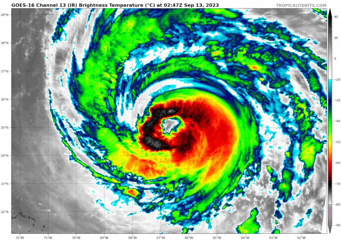
Re: ATL: LEE - Hurricane - Discussion
Eye is fully cleared out and becoming more round:
0 likes
TC naming lists: retirements and intensity
Most aggressive Advisory #1's in North Atlantic (cr. kevin for starting the list)
Most aggressive Advisory #1's in North Atlantic (cr. kevin for starting the list)
-
Sciencerocks
- Category 5
- Posts: 10181
- Age: 40
- Joined: Thu Jul 06, 2017 1:51 am


Re: ATL: LEE - Hurricane - Discussion
A caveat for people quoting the wind probability map: it’s good guidance in relative terms, but the past few NHC advisory discussions have said it probably underestimates probabilities overall, due to the size of the storm being larger than the average-sized storm that’s used in the models that generate those maps. From Advisory 31’s discussion:
It should again be noted that the 34- and 50-kt wind speed
probabilities beyond 36 hours in the text product and graphics are
likely underestimating the risk of those winds occurring. This is
because the forecast wind field of Lee is considerably larger than
average compared to the wind field used to derive the wind speed
probability product.
3 likes
-
dukeblue219
- S2K Supporter

- Posts: 556
- Joined: Fri Sep 30, 2016 3:52 pm
Re: ATL: LEE - Hurricane - Discussion
A big piece of the storm went missing overnight. Not looking particularly healthy to my eye this morning.

2 likes
Who is online
Users browsing this forum: No registered users and 129 guests