ATL: HAROLD - Remnants - Discussion
Moderator: S2k Moderators
-
Edwards Limestone

- S2K Supporter

- Posts: 517
- Age: 36
- Joined: Tue Dec 28, 2021 11:05 am
- Location: Smithson Valley, TX
Re: ATL: HAROLD - Tropical Storm - Discussion
Seems to be inching further north
1 likes
The above post is NOT an official forecast and should not be used as such. It is just the opinion of the poster and may or may not be backed by sound meteorological data. It is NOT endorsed by any professional institution including Storm2k. For official information, please refer to NWS products.
-
CrazyC83
- Professional-Met

- Posts: 34316
- Joined: Tue Mar 07, 2006 11:57 pm
- Location: Deep South, for the first time!
Re: ATL: HAROLD - Tropical Storm - Discussion
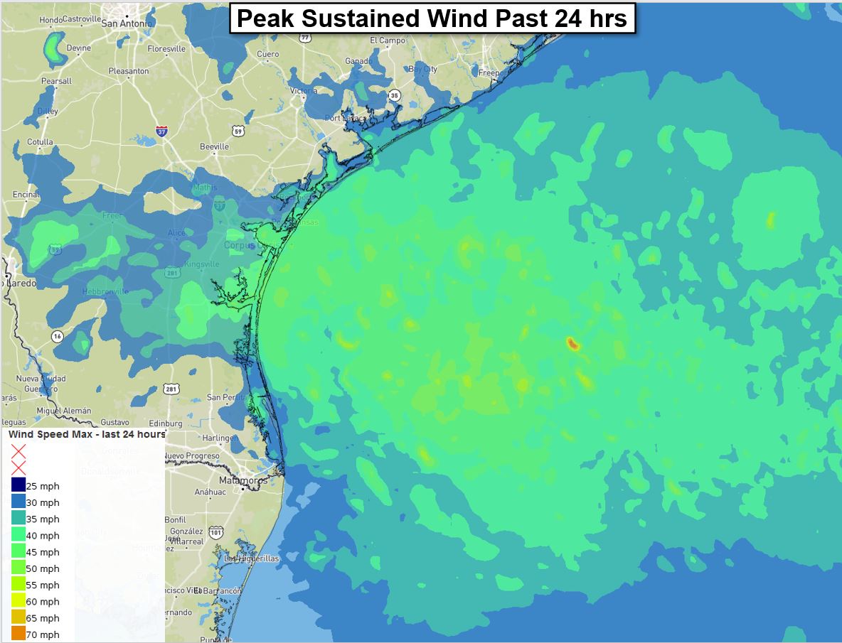
Based on the wind reports (gusts to nearly 70 mph) and pressure drop, I would set the landfall intensity at 50 kt (pressure 996 mb). It probably would have become a hurricane if it had 12 more hours over water.
0 likes
-
Sciencerocks
- Category 5

- Posts: 10194
- Age: 40
- Joined: Thu Jul 06, 2017 1:51 am

-
wxman57

- Moderator-Pro Met

- Posts: 23176
- Age: 68
- Joined: Sat Jun 21, 2003 8:06 pm
- Location: Houston, TX (southwest)
Re: ATL: HAROLD - Tropical Storm - Discussion
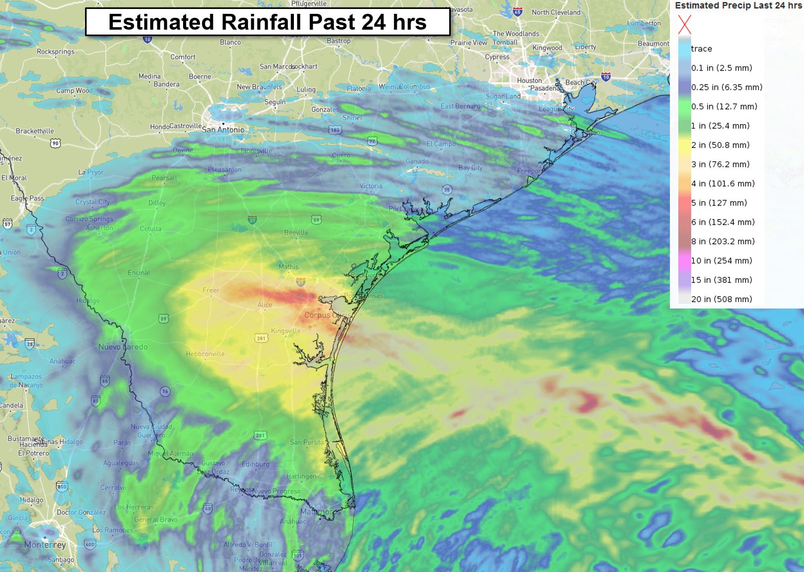
Here's a 24 hr rainfall map I made. Looks like about 3-5 inches in Corpus. About nothing in Brownsville. I went outside an hour ago and could smell rain in the air. Didn't see any fall, but it was around, somewhere.
0 likes
-
wxman57
- Moderator-Pro Met
- Posts: 23176
- Age: 68
- Joined: Sat Jun 21, 2003 8:06 pm
- Location: Houston, TX (southwest)
Re: ATL: HAROLD - Tropical Storm - Discussion
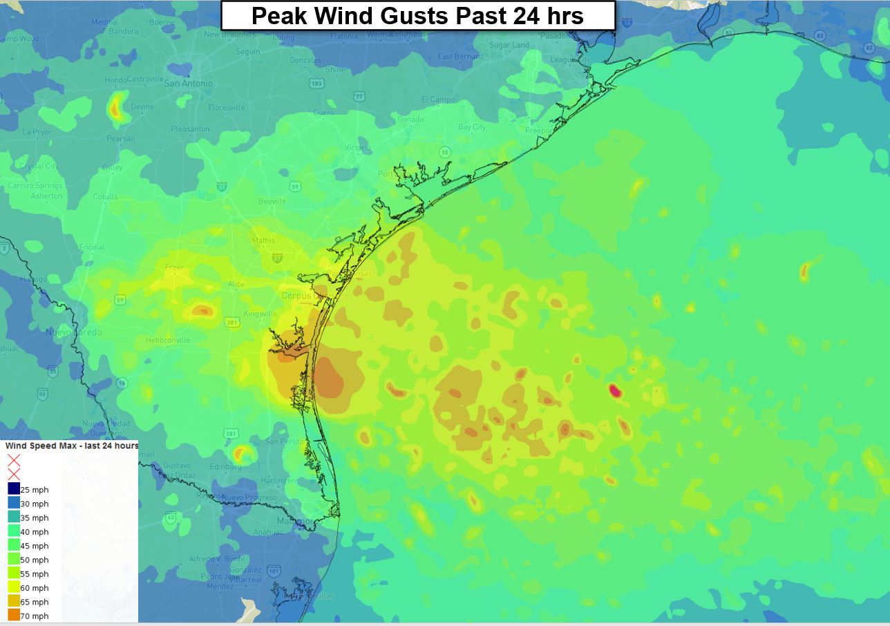
Peak sustained wind and gusts here. The small orange patch in the gusts graphic near Corpus Christi is that wind report of 63 mph.
0 likes
-
Craters
- Category 1

- Posts: 428
- Joined: Sat Aug 24, 2013 2:34 pm
- Location: Alvin, TX (south of Houston)
Re: ATL: HAROLD - Tropical Storm - Discussion
wxman57 wrote:Here's a 24 hr rainfall map I made. Looks like about 3-5 inches in Corpus. About nothing in Brownsville. I went outside an hour ago and could smell rain in the air. Didn't see any fall, but it was around, somewhere.
http://wxman57.com/images/HaroldRain.jpg
If you could smell horses and/or cattle along with the rain, there's a good chance that it was Alvin you were smelling.
1 likes
Nothing that I post here should ever be treated as a forecast or anything resembling one. Please check with your local NWS office or the NHC for forecasts, watches, and warnings.
-
Craters
- Category 1
- Posts: 428
- Joined: Sat Aug 24, 2013 2:34 pm
- Location: Alvin, TX (south of Houston)
Re: ATL: HAROLD - Tropical Storm - Discussion
CrazyC83 wrote:Based on the wind reports (gusts to nearly 70 mph) and pressure drop, I would set the landfall intensity at 50 kt (pressure 996 mb). It probably would have become a hurricane if it had 12 more hours over water.
A question for you and WxMan57 while this is still fresh, Crazy — did Harold intensify any faster than you normally would have expected? RI has received a lot of attention lately, and this was a spot where I'm thinking that it would have happened, if anywhere. Or was the system still too diffuse to make it a good test? Thanks!
1 likes
Nothing that I post here should ever be treated as a forecast or anything resembling one. Please check with your local NWS office or the NHC for forecasts, watches, and warnings.
-
cycloneye

- Admin

- Posts: 149807
- Age: 69
- Joined: Thu Oct 10, 2002 10:54 am
- Location: San Juan, Puerto Rico
Re: ATL: HAROLD - Tropical Storm - Discussion
BULLETIN
Tropical Depression Harold Advisory Number 6
NWS National Hurricane Center Miami FL AL092023
400 PM CDT Tue Aug 22 2023
...HAROLD WEAKENS TO A DEPRESSION BUT HEAVY RAINS CONTINUE...
...NEXT ADVISORY WILL BE ISSUED BY THE WEATHER PREDICTION CENTER...
SUMMARY OF 400 PM CDT...2100 UTC...INFORMATION
----------------------------------------------
LOCATION...27.6N 99.3W
ABOUT 15 MI...25 KM E OF LAREDO TEXAS
MAXIMUM SUSTAINED WINDS...35 MPH...55 KM/H
PRESENT MOVEMENT...WNW OR 290 DEGREES AT 21 MPH...33 KM/H
MINIMUM CENTRAL PRESSURE...999 MB...29.50 INCHES
Tropical Depression Harold Discussion Number 6
NWS National Hurricane Center Miami FL AL092023
400 PM CDT Tue Aug 22 2023
Harold has been moving quickly inland over south Texas and
weakening. Surface observations indicate that the maximum winds
are now around 30 kt, making the system a tropical depression.
Despite the decrease in winds, the minimum pressure remains fairly
low, 999 mb, and heavy rains continue to affect a large portion of
southern Texas.
Harold is moving to the west-northwest at about 20 kt in the flow on
the south side of a strong mid-level ridge. The depression is
expected to move farther inland across southern Texas and northern
Mexico until it dissipates on Wednesday.
This is the last advisory issued by the National Hurricane Center on
Harold. Future information on this system can be found in
discussions issued by the Weather Prediction Center beginning at
1000 PM CDT, under AWIPS header TCDAT4, WMO header WTNT24 KWNH, and
on the web at www.hurricanes.gov.
KEY MESSAGES:
1. Heavy rainfall is expected across south Texas through early
Wednesday, and may produce areas of flash and urban flooding. Across
portions of northern Coahuila and northern Nuevo Leon in Mexico,
flash flooding with possible landslides in mountainous terrain is
expected through Wednesday.
FORECAST POSITIONS AND MAX WINDS
INIT 22/2100Z 27.6N 99.3W 30 KT 35 MPH
12H 23/0600Z 28.7N 101.9W 25 KT 30 MPH...INLAND
24H 23/1800Z...DISSIPATED
$$
Forecaster Cangialosi
0 likes
Visit the Caribbean-Central America Weather Thread where you can find at first post web cams,radars
and observations from Caribbean basin members Click Here
and observations from Caribbean basin members Click Here
-
wxman57
- Moderator-Pro Met
- Posts: 23176
- Age: 68
- Joined: Sat Jun 21, 2003 8:06 pm
- Location: Houston, TX (southwest)
Re: ATL: HAROLD - Tropical Depression - Discussion
Radar shows some showers passing through Austin.
1 likes
-
wxman57
- Moderator-Pro Met
- Posts: 23176
- Age: 68
- Joined: Sat Jun 21, 2003 8:06 pm
- Location: Houston, TX (southwest)
Re: ATL: HAROLD - Tropical Storm - Discussion
Craters wrote:CrazyC83 wrote:Based on the wind reports (gusts to nearly 70 mph) and pressure drop, I would set the landfall intensity at 50 kt (pressure 996 mb). It probably would have become a hurricane if it had 12 more hours over water.
A question for you and WxMan57 while this is still fresh, Crazy — did Harold intensify any faster than you normally would have expected? RI has received a lot of attention lately, and this was a spot where I'm thinking that it would have happened, if anywhere. Or was the system still too diffuse to make it a good test? Thanks!
My forecast was for a peak sustained wind of 50 kts as the center reached the coast. We saw the center reform under the convection right at landfall. I think Harold struggled with very fast easterly flow aloft, due to that strong ridge. Too much wind shear. Models handled it very well, indicating some strengthening right at landfall.
3 likes
-
CrazyC83
- Professional-Met
- Posts: 34316
- Joined: Tue Mar 07, 2006 11:57 pm
- Location: Deep South, for the first time!
Re: ATL: HAROLD - Tropical Storm - Discussion
wxman57 wrote:Craters wrote:CrazyC83 wrote:Based on the wind reports (gusts to nearly 70 mph) and pressure drop, I would set the landfall intensity at 50 kt (pressure 996 mb). It probably would have become a hurricane if it had 12 more hours over water.
A question for you and WxMan57 while this is still fresh, Crazy — did Harold intensify any faster than you normally would have expected? RI has received a lot of attention lately, and this was a spot where I'm thinking that it would have happened, if anywhere. Or was the system still too diffuse to make it a good test? Thanks!
My forecast was for a peak sustained wind of 50 kts as the center reached the coast. We saw the center reform under the convection right at landfall. I think Harold struggled with very fast easterly flow aloft, due to that strong ridge. Too much wind shear. Models handled it very well, indicating some strengthening right at landfall.
It seemed to be strengthening at a good clip in the last few hours before landfall though. Shear was decreasing as it moved west, the TUTT wasn't a big factor in the western Gulf.
2 likes
-
Portastorm

- Storm2k Moderator

- Posts: 9955
- Age: 63
- Joined: Fri Jul 11, 2003 9:16 am
- Location: Round Rock, TX
- Contact:
Re: ATL: HAROLD - Tropical Depression - Discussion
wxman57 wrote:Radar shows some showers passing through Austin.
Shockingly it did rain in southern portions of Travis County and in the downtown area. Less than 1/4" but the first rain since July 7.
2 likes
Any forecasts under my name are to be taken with a grain of salt. Get your best forecasts from the National Weather Service and National Hurricane Center.
-
Edwards Limestone
- S2K Supporter
- Posts: 517
- Age: 36
- Joined: Tue Dec 28, 2021 11:05 am
- Location: Smithson Valley, TX
Re: ATL: HAROLD - Tropical Depression - Discussion
Harold overachieving rainfall-wise IMO. I didn't expect anything significant north of I-10 really.
1 likes
The above post is NOT an official forecast and should not be used as such. It is just the opinion of the poster and may or may not be backed by sound meteorological data. It is NOT endorsed by any professional institution including Storm2k. For official information, please refer to NWS products.
-
South Texas Storms

- Professional-Met
- Posts: 4263
- Joined: Thu Jun 24, 2010 12:28 am
- Location: Houston, TX
Re: ATL: HAROLD - Tropical Depression - Discussion
Edwards Limestone wrote:Harold overachieving rainfall-wise IMO. I didn't expect anything significant north of I-10 really.
Sure did! 0.75 inch today in SA was very beneficial and appreciated!
2 likes
-
Sciencerocks
- Category 5
- Posts: 10194
- Age: 40
- Joined: Thu Jul 06, 2017 1:51 am

-
cycloneye
- Admin
- Posts: 149807
- Age: 69
- Joined: Thu Oct 10, 2002 10:54 am
- Location: San Juan, Puerto Rico
Re: ATL: HAROLD - Tropical Depression - Discussion
BULLETIN
Tropical Depression Harold Advisory Number 7
NWS Weather Prediction Center College Park MD AL092023
1000 PM CDT Tue Aug 22 2023
...HAROLD CROSSES INTO NORTHERN MEXICO WITH HEAVY RAINS
CONTINUING...
SUMMARY OF 1000 PM CDT...0300 UTC...INFORMATION
-----------------------------------------------
LOCATION...27.4N 100.2W
ABOUT 45 MI...70 KM WSW OF LAREDO TEXAS
ABOUT 480 MI...775 KM SE OF EL PASO TEXAS
MAXIMUM SUSTAINED WINDS...35 MPH...55 KM/H
PRESENT MOVEMENT...WNW OR 300 DEGREES AT 18 MPH...30 KM/H
MINIMUM CENTRAL PRESSURE...1002 MB...29.59 INCHES
Tropical Depression Harold Discussion Number 7
NWS Weather Prediction Center College Park MD AL092023
1000 PM CDT Tue Aug 22 2023
KEY MESSAGES:
1. Heavy rainfall from Harold is expected to shift from South
Texas to Southwest Texas through Wednesday and will produce
isolated to widely scattered flash flooding. Across portions
of far northern Mexico flash flooding with possible landslides
in mountainous terrain is expected through Wednesday.
FORECAST POSITIONS AND MAX WINDS
INIT 23/0300Z 27.4N 100.2W 30 KT 35 MPH...INLAND
12H 23/1200Z 28.8N 102.9W 25 KT 30 MPH...INLAND
24H 24/0000Z 31.2N 106.8W 20 KT 25 MPH...DISSIPATED
$$
Forecaster Gallina
0 likes
Visit the Caribbean-Central America Weather Thread where you can find at first post web cams,radars
and observations from Caribbean basin members Click Here
and observations from Caribbean basin members Click Here
-
cycloneye
- Admin
- Posts: 149807
- Age: 69
- Joined: Thu Oct 10, 2002 10:54 am
- Location: San Juan, Puerto Rico
Re: ATL: HAROLD - Tropical Depression - Discussion
1 likes
Visit the Caribbean-Central America Weather Thread where you can find at first post web cams,radars
and observations from Caribbean basin members Click Here
and observations from Caribbean basin members Click Here
Re: ATL: HAROLD - Tropical Depression - Discussion
Pretty unusual for us to feel even indirect effects of tropical weather up here in Denver, but looks like we too will get some rain out of Harold.
Key Messages...
1. The strong upper level ridge over the Great Plains/Midwest will
break down this week, bringing relief from the near-record heat
2. The remnants of now-Tropical Depression Harold will bring a
substantial amount of moisture to the region by late-week
3. Locally heavy rainfall will be possible Thursday into the
weekend across portions of the forecast area
1 likes
-
cycloneye
- Admin
- Posts: 149807
- Age: 69
- Joined: Thu Oct 10, 2002 10:54 am
- Location: San Juan, Puerto Rico
Re: ATL: HAROLD - Tropical Depression - Discussion
BULLETIN
Tropical Depression Harold Advisory Number 8
NWS Weather Prediction Center College Park MD AL092023
400 AM CDT Wed Aug 23 2023
...HAROLD WEAKENS WHILE CROSSING NORTHERN MEXICO...HEAVY RAINS
CONTINUING...
SUMMARY OF 400 AM CDT...0900 UTC...INFORMATION
----------------------------------------------
LOCATION...28.6N 102.1W
ABOUT 235 MI...380 KM S OF MIDLAND TEXAS
ABOUT 340 MI...545 KM SE OF EL PASO TEXAS
MAXIMUM SUSTAINED WINDS...30 MPH...45 KM/H
PRESENT MOVEMENT...WNW OR 300 DEGREES AT 14 MPH...22 KM/H
MINIMUM CENTRAL PRESSURE...1005 MB...29.68 INCHES
WATCHES AND WARNINGS
--------------------
SUMMARY OF WATCHES AND WARNINGS IN EFFECT:
Flood Watch is in effect across portions of the Trans-Pecos and Big
Bend regions of Texas.
Interests in Southwestern U.S. and northern Mexico should continue
to monitor the progress of this system.
For storm information specific to your area, including possible
inland watches and warnings, please monitor products issued by your
local National Weather Service forecast office.
DISCUSSION AND OUTLOOK
----------------------
At 400 AM CDT (0900 UTC), the center of Tropical Depression Harold
was located near latitude 28.6 North, longitude 102.1 West. The
depression is moving toward the west-northwest near 14 mph (22 km/h)
and this motion is expected to continue with some acceleration into
Thursday morning
Maximum sustained winds are near 30 mph (45 km/h) with higher gusts.
Harold is expected to dissipate as a tropical cyclone as its
surface center devolves while tracking across far northern Mexico.
The estimated minimum central pressure is 1005 mb (29.68 inches).
HAZARDS AFFECTING LAND
----------------------
Key messages for Harold can be found in the Tropical Cyclone
Discussion under AWIPS header TCDAT4 and WMO header WTNT44 KWNH
and on the web at www.hurricanes.gov.
RAINFALL: Harold is expected to produce rainfall amounts of 1
to 2 inches with isolated higher amounts of 4 inches across the
Big Bend and Trans Pecos regions of Texas as well as southern New
Mexico through tonight. Isolated to widely scattered instances of
flash flooding are possible.
In far northern Mexico, rainfall amounts of 4 to 6 inches, with
local amounts of 10 inches are expected today. Scattered instances
of flash flooding are expected with landslides possible.
WIND: Gusty winds are possible in the Big Bend and Trans Pecos
regions of Texas, southern New Mexico, and northernmost Mexico
through tonight. Winds could be particularly gusty in and
near areas of elevated terrain. Higher gusts could persist even
after the system dissipates.
NEXT ADVISORY
-------------
Next complete advisory at 1000 AM CDT.
$$
Forecaster Roth
0 likes
Visit the Caribbean-Central America Weather Thread where you can find at first post web cams,radars
and observations from Caribbean basin members Click Here
and observations from Caribbean basin members Click Here
Re: ATL: HAROLD - Tropical Depression - Discussion
bjackrian wrote:Pretty unusual for us to feel even indirect effects of tropical weather up here in Denver, but looks like we too will get some rain out of Harold.Key Messages...
1. The strong upper level ridge over the Great Plains/Midwest will
break down this week, bringing relief from the near-record heat
2. The remnants of now-Tropical Depression Harold will bring a
substantial amount of moisture to the region by late-week
3. Locally heavy rainfall will be possible Thursday into the
weekend across portions of the forecast area
Harold hung in and stayed strong a lot longer than I thought he would. I was surprised to open this site this morning and see he's still got an "icon" and a name!
1 likes
Cleo - 1964, Betsy - 1965, David - 1979, Andrew - 1992, Charlie (Francis, Ivan, Jeanne) - 2004, Irma - 2017, Ian - 2022, Milton - 2024
Who is online
Users browsing this forum: No registered users and 46 guests