CPAC: CALVIN - Post-Tropical - Discussion
Moderator: S2k Moderators
-
Yellow Evan

- Professional-Met

- Posts: 16231
- Age: 27
- Joined: Fri Jul 15, 2011 12:48 pm
- Location: Henderson, Nevada/Honolulu, HI
- Contact:
Re: EPAC: CALVIN - Hurricane - Discussion
No idea what estimates the NHC used at 6z... D-Print, SATCON, and SAB all supported 93-102 knots with only TAFB, AiDT, and ADT lower, the latter of which has missed the EYE half the time.
0 likes

Re: EPAC: CALVIN - Hurricane - Discussion
CIMSS TC real time intensity product has it at a average speed of 104kt cat 3.
https://tropic.ssec.wisc.edu/real-time/ ... ry_IR.html

https://tropic.ssec.wisc.edu/real-time/ ... ry_IR.html
0 likes
-
Yellow Evan
- Professional-Met
- Posts: 16231
- Age: 27
- Joined: Fri Jul 15, 2011 12:48 pm
- Location: Henderson, Nevada/Honolulu, HI
- Contact:
Re: EPAC: CALVIN - Hurricane - Discussion

Of course, now that synoptic time is passed, this is re-wejjing. Solid T6.0 with eye warming steadily.
0 likes
-
Yellow Evan
- Professional-Met
- Posts: 16231
- Age: 27
- Joined: Fri Jul 15, 2011 12:48 pm
- Location: Henderson, Nevada/Honolulu, HI
- Contact:
Re: EPAC: CALVIN - Hurricane - Discussion
TXPZ28 KNES 141229
TCSENP
A. 03E (CALVIN)
B. 14/1200Z
C. 13.5N
D. 122.5W
E. ONE/GOES-W
F. T5.5/5.5
G. IR/EIR
H. REMARKS...WMG EYE IS EMBEDDED AND SURROUNDED BY LG WITH 0.5 ADDED
FOR EYE ADJUSTMENT YIELDING A DT OF 5.5. MET = 5.0 AND PT = 5.5. THE FT
IS BASED ON THE DT.
I. ADDL POSITIONS
NIL
...KIBLER
TCSENP
A. 03E (CALVIN)
B. 14/1200Z
C. 13.5N
D. 122.5W
E. ONE/GOES-W
F. T5.5/5.5
G. IR/EIR
H. REMARKS...WMG EYE IS EMBEDDED AND SURROUNDED BY LG WITH 0.5 ADDED
FOR EYE ADJUSTMENT YIELDING A DT OF 5.5. MET = 5.0 AND PT = 5.5. THE FT
IS BASED ON THE DT.
I. ADDL POSITIONS
NIL
...KIBLER
Guess it made it to 5.5 on time.
0 likes
-
Yellow Evan
- Professional-Met
- Posts: 16231
- Age: 27
- Joined: Fri Jul 15, 2011 12:48 pm
- Location: Henderson, Nevada/Honolulu, HI
- Contact:
Re: EPAC: CALVIN - Hurricane - Discussion


Objective estimates from D Print and ADT are in a lot better agreement than they were any time post-eye clearing.
0 likes
-
Yellow Evan
- Professional-Met
- Posts: 16231
- Age: 27
- Joined: Fri Jul 15, 2011 12:48 pm
- Location: Henderson, Nevada/Honolulu, HI
- Contact:
Re: EPAC: CALVIN - Hurricane - Discussion
EP, 03, 2023071412, , BEST, 0, 134N, 1225W, 100, 963, HU, 64, NEQ, 25, 15, 15, 25, 1008, 180, 15, 0, 0, E, 0, , 0, 0, CALVIN, D, 0, , 0, 0, 0, 0, genesis-num, 007,
0 likes
-
Yellow Evan
- Professional-Met
- Posts: 16231
- Age: 27
- Joined: Fri Jul 15, 2011 12:48 pm
- Location: Henderson, Nevada/Honolulu, HI
- Contact:
Re: EPAC: CALVIN - Hurricane - Discussion
EP, 03, 202307141200, 10, DVTS, CI, , 1340N, 12250W, , 1, 102, 2, 960, 2, DVRK, , , , , , , , , , , , , 15, E, TAFB, JA, I, 1, 5555 /////, , , GOES18, CSC, T, WMG eye embedded in LG and surrounded by LG with +0.5
0 likes
-
Kingarabian

- S2K Supporter

- Posts: 16348
- Joined: Sat Aug 08, 2009 3:06 am
- Location: Honolulu, Hawaii
Re: EPAC: CALVIN - Hurricane - Discussion
Overall its structure doesn't look too helpful in becoming a high end major with marginal conditions approaching. NHC should go with MH this update though.
Last edited by Kingarabian on Fri Jul 14, 2023 9:02 am, edited 1 time in total.
0 likes
RIP Kobe Bryant
-
Hurricane2022

- Category 5

- Posts: 2016
- Joined: Tue Aug 23, 2022 11:38 pm
- Location: Araçatuba, Brazil
Re: EPAC: CALVIN - Hurricane - Discussion
Hopefully Calvin will intensify to Category 4 before weakening over the cold waters.
0 likes
Sorry for the bad English sometimes...!
For reliable and detailed information for any meteorological phenomenon, please consult the National Hurricane Center, Joint Typhoon Warning Center , or your local Meteo Center.
--------
ECCE OMNIA NOVA FACIAM (Ap 21,5).
For reliable and detailed information for any meteorological phenomenon, please consult the National Hurricane Center, Joint Typhoon Warning Center , or your local Meteo Center.
--------
ECCE OMNIA NOVA FACIAM (Ap 21,5).
-
Sciencerocks
- Category 5
- Posts: 10181
- Age: 40
- Joined: Thu Jul 06, 2017 1:51 am

-
Sciencerocks
- Category 5
- Posts: 10181
- Age: 40
- Joined: Thu Jul 06, 2017 1:51 am

-
Sciencerocks
- Category 5
- Posts: 10181
- Age: 40
- Joined: Thu Jul 06, 2017 1:51 am
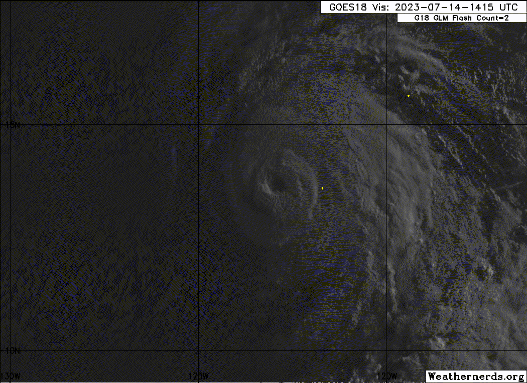
Re: EPAC: CALVIN - Hurricane - Discussion
Hurricane Calvin Discussion Number 12
NWS National Hurricane Center Miami FL EP032023
500 AM HST Fri Jul 14 2023
Calvin has rapidly intensified since yesterday morning. The latest
geostationary satellite imagery shows the hurricane has a warm and
well-defined 15 n-mi-wide eye, with a pronounced ring of deep
convection surrounding it in recent passive microwave imagery. The
latest subjective Dvorak estimates are a consensus T5.5/102 kt from
TAFB and SAB, and the various objective estimates have continued to
rise this morning and range from 96-110 kt. The initial intensity is
raised to 105 kt for this advisory, making Calvin the first major
hurricane of the 2023 eastern Pacific season.
Some additional strengthening is possible today as Calvin remains
embedded within a moist, low-shear environment over sufficiently
warm sea-surface temperatures (SST). The hurricane is expected to
cross the 26C SST isotherm by tomorrow, which should cause its
intensity to level off and eventually induce some weakening as it
moves over cooler waters. Early next week, Calvin is likely to
continue weakening as it encounters less favorable environmental
conditions with increased deep-layer shear and a drier mid-level
environment along its track. Based on recent intensity trends, the
updated NHC forecast lies above the multi-model consensus aids
through 48 h, then more closely agrees with HCCA and IVCN through
the rest of the period.
Calvin's long-term motion is still westward, or 280/14 kt. A
well-established subtropical ridge over the eastern Pacific will
steer Calvin generally westward to west-northwestward through early
next week. The track models remain in very good agreement with
little cross-track spread noted throughout the forecast period, and
the latest NHC forecast is essentially an update of the previous
one. This brings Calvin across 140W and into the central Pacific
basin by early Monday morning, then toward the Hawaiian Islands
thereafter. Given uncertainties about the status and intensity of
Calvin near the end of the 5-day period, interests in Hawaii should
closely monitor the latest forecast updates.
FORECAST POSITIONS AND MAX WINDS
INIT 14/1500Z 13.6N 123.2W 105 KT 120 MPH
12H 15/0000Z 14.0N 125.3W 110 KT 125 MPH
24H 15/1200Z 14.7N 128.1W 100 KT 115 MPH
36H 16/0000Z 15.3N 131.0W 90 KT 105 MPH
48H 16/1200Z 16.0N 133.9W 75 KT 85 MPH
60H 17/0000Z 16.6N 137.0W 60 KT 70 MPH
72H 17/1200Z 17.2N 140.4W 50 KT 60 MPH
96H 18/1200Z 17.9N 147.8W 40 KT 45 MPH
120H 19/1200Z 19.0N 155.5W 35 KT 40 MPH...POST-TROPICAL
$$
Forecaster Reinhart
1 likes


Re: EPAC: CALVIN - Hurricane - Discussion
Eye isn't as warm, but still cold tops. Might have peaked but certainly picturesque.
0 likes
The above post and any post by Ntxw is NOT an official forecast and should not be used as such. It is just the opinion of the poster and may or may not be backed by sound meteorological data. It is NOT endorsed by any professional institution including Storm2k. For official information, please refer to NWS products.
Help support Storm2K!

-
Hurricane2022
- Category 5
- Posts: 2016
- Joined: Tue Aug 23, 2022 11:38 pm
- Location: Araçatuba, Brazil
Re: EPAC: CALVIN - Hurricane - Discussion
0 likes
Sorry for the bad English sometimes...!
For reliable and detailed information for any meteorological phenomenon, please consult the National Hurricane Center, Joint Typhoon Warning Center , or your local Meteo Center.
--------
ECCE OMNIA NOVA FACIAM (Ap 21,5).
For reliable and detailed information for any meteorological phenomenon, please consult the National Hurricane Center, Joint Typhoon Warning Center , or your local Meteo Center.
--------
ECCE OMNIA NOVA FACIAM (Ap 21,5).
-
Yellow Evan
- Professional-Met
- Posts: 16231
- Age: 27
- Joined: Fri Jul 15, 2011 12:48 pm
- Location: Henderson, Nevada/Honolulu, HI
- Contact:
Re: EPAC: CALVIN - Hurricane - Discussion
Ntxw wrote:Eye isn't as warm, but still cold tops. Might have peaked but certainly picturesque.
Due to the shear vector, we haven’t gotten the annular structure most storms in this basin are known for. Otherwise this would be much closer to the legendary annular storms of the last 2 Julys (and probably a bit stronger since the shear vector would offset beta drift).
1 likes
-
Sciencerocks
- Category 5
- Posts: 10181
- Age: 40
- Joined: Thu Jul 06, 2017 1:51 am
-
Yellow Evan
- Professional-Met
- Posts: 16231
- Age: 27
- Joined: Fri Jul 15, 2011 12:48 pm
- Location: Henderson, Nevada/Honolulu, HI
- Contact:
Re: EPAC: CALVIN - Hurricane - Discussion

Set for a T6.0. WMG embedded in LG surrounded by B. Eye slowly warming and CDO is axissymmetrizating. Eye still isn’t particularly well defined though.
1 likes
-
Yellow Evan
- Professional-Met
- Posts: 16231
- Age: 27
- Joined: Fri Jul 15, 2011 12:48 pm
- Location: Henderson, Nevada/Honolulu, HI
- Contact:
Re: EPAC: CALVIN - Hurricane - Discussion
TXPZ27 KNES 141815
TCSENP
A. 03E (CALVIN)
B. 14/1800Z
C. 13.7N
D. 123.9W
E. ONE/HIMAWARI-9
F. T6.0/6.0
G. IR/EIR/VIS
H. REMARKS...WMG EYE IS SURROUNDED BY B AND EMBEDDED IN LG RESULTING IN
A DT OF 6.0 WHICH INCLUDES AN EYE ADJUSTMENT OF 1.0. MET = 5.5 AND PT =
6.0 THE FT IS BASED ON THE DT.
I. ADDL POSITIONS
NIL
...KIBLER
0 likes
-
Yellow Evan
- Professional-Met
- Posts: 16231
- Age: 27
- Joined: Fri Jul 15, 2011 12:48 pm
- Location: Henderson, Nevada/Honolulu, HI
- Contact:
Re: EPAC: CALVIN - Hurricane - Discussion
EP, 03, 2023071418, , BEST, 0, 137N, 1239W, 110, 955, HU, 64, NEQ, 30, 25, 20, 25, 1008, 180, 10, 0, 0, E, 0, , 0, 0, CALVIN, D, 0, , 0, 0, 0, 0, genesis-num, 007,
0 likes
-
Yellow Evan
- Professional-Met
- Posts: 16231
- Age: 27
- Joined: Fri Jul 15, 2011 12:48 pm
- Location: Henderson, Nevada/Honolulu, HI
- Contact:
Re: EPAC: CALVIN - Hurricane - Discussion
EP, 03, 202307141800, 10, DVTS, CI, , 1370N, 12390W, , 1, 115, 2, , , , , , , , , , , , , , , , , E, SAB, JK, VIM, 1, 6060 /////, , , HMWRI9, LLCC, T, DT=6.0 BO EYE MET=5.5 PT=6.0 FTBO DT
EP, 03, 202307141800, 10, DVTS, CI, , 1360N, 12390W, , 1, 115, 2, 948, 2, DVRK, , , , , , , , , , , , , , E, TAFB, GR, VI, 1, 6060 /////, , , GOES18, CSC, T,
EP, 03, 202307141800, 10, DVTS, CI, , 1360N, 12390W, , 1, 115, 2, 948, 2, DVRK, , , , , , , , , , , , , , E, TAFB, GR, VI, 1, 6060 /////, , , GOES18, CSC, T,
0 likes
Who is online
Users browsing this forum: No registered users and 35 guests