ATL: IDALIA - Models
Moderator: S2k Moderators
Re: ATL: INVEST 93L - Models
Hwrf ar 54 hrs is near hurricane and way east in the carribean still! 
0 likes
-
SconnieCane
- Category 5

- Posts: 1013
- Joined: Thu Aug 02, 2018 5:29 pm
- Location: Madison, WI
Re: ATL: INVEST 93L - Models
Ianswfl wrote:Hwrf ar 54 hrs is near hurricane and way east in the carribean still!
Yeah, this 0Z is gonna be one of those "fun" runs...
0 likes
Re: ATL: INVEST 93L - Models
SconnieCane wrote:Ianswfl wrote:Hwrf ar 54 hrs is near hurricane and way east in the carribean still!
Yeah, this 0Z is gonna be one of those "fun" runs...
Hr 63 a hurricane about to make landfall tip of cuba! Swfl uh oh.
0 likes
Re: ATL: INVEST 93L - Models
Hwrf 72 hrs 80kts! Heading tick east of due north! Euro much more east and stronger so far. Looks like this could be stronger than we thought 
0 likes
-
AutoPenalti
- Category 5
- Posts: 4091
- Age: 29
- Joined: Mon Aug 17, 2015 4:16 pm
- Location: Ft. Lauderdale, Florida
Re: ATL: INVEST 93L - Models
HWRF is insane lol…
It heads NNE and then veers to a NNW heading.
It heads NNE and then veers to a NNW heading.
0 likes
The posts in this forum are NOT official forecasts and should not be used as such. They are just the opinion of the poster and may or may not be backed by sound meteorological data. They are NOT endorsed by any professional institution or STORM2K. For official information, please refer to products from the NHC and NWS.
Model Runs Cheat Sheet:
GFS (5:30 AM/PM, 11:30 AM/PM)
HWRF, GFDL, UKMET, NAVGEM (6:30-8:00 AM/PM, 12:30-2:00 AM/PM)
ECMWF (1:45 AM/PM)
TCVN is a weighted averaged
Re: ATL: INVEST 93L - Models
AutoPenalti wrote:HWRF is insane lol…
It heads NNE and then veers to a NNW heading.
Euro more east and stronger than 18z so far
0 likes

Re: ATL: INVEST 93L - Models
Unless it gets hung up longer,70% Chance this landfalls between Bay and Dixie Counties, 20% chance south of Dixie County, 8% chance somewhere between Santa Rosa and Bay and maybe a 2% chance further west or south (though if it kicks out quicker than 96 hours decent chance of an exit through SWFL
0 likes
Re: ATL: INVEST 93L - Models
00z euro looks a bit south for landfall compared to 12z. Hours in between skip landfall so extrapolating.
0 likes
-
REDHurricane

- Category 1

- Posts: 438
- Age: 28
- Joined: Sun Jul 03, 2022 2:36 pm
- Location: Northeast Pacific Ocean
Re: ATL: INVEST 93L - Models
Even with the 00z hurricane model runs trending stronger, to me it still looks like the models are initializing the CoC a little too far to the west -- if this system gets to spend the next 48-72 hours over mostly over water (more east solution) instead of mostly over land (more west solution), the high cat 1 landfall forecast by HWRF could easily turn into a major hurricane; I think even a cat 4 or 5 wouldn't be out of the question in that scenario.
Little to no wind shear, abundant moisture, 30ºC and higher SST everywhere in the Gulf, and a system (which already appears to be strengthening faster than model guidance has suggested) getting to sit over water for two or three days extra? Time for the NHC to designate this a PTC or at least a TD so people can be aware of what could be coming their way within just 4-5 days...
Little to no wind shear, abundant moisture, 30ºC and higher SST everywhere in the Gulf, and a system (which already appears to be strengthening faster than model guidance has suggested) getting to sit over water for two or three days extra? Time for the NHC to designate this a PTC or at least a TD so people can be aware of what could be coming their way within just 4-5 days...
0 likes
-
AtlanticWind

- S2K Supporter

- Posts: 1898
- Age: 67
- Joined: Sun Aug 08, 2004 9:57 pm
- Location: Plantation,Fla
Re: ATL: INVEST 93L - Models
REDHurricane wrote:Even with the 00z hurricane model runs trending stronger, to me it still looks like the models are initializing the CoC a little too far to the west -- if this system gets to spend the next 48-72 hours over mostly over water (more east solution) instead of mostly over land (more west solution), the high cat 1 landfall forecast by HWRF could easily turn into a major hurricane; I think even a cat 4 or 5 wouldn't be out of the question in that scenario.
Little to no wind shear, abundant moisture, 30ºC and higher SST everywhere in the Gulf, and a system (which already appears to be strengthening faster than model guidance has suggested) getting to sit over water for two or three days extra? Time for the NHC to designate this a PTC or at least a TD so people can be aware of what could be coming their way within just 4-5 days...
There really isn’t any model support for major hurricane, I suppose that could change
but it takes ideal conditions for a cat 4 or 5
0 likes
-
REDHurricane
- Category 1
- Posts: 438
- Age: 28
- Joined: Sun Jul 03, 2022 2:36 pm
- Location: Northeast Pacific Ocean
Re: ATL: INVEST 93L - Models
AtlanticWind wrote:There really isn’t any model support for major hurricane, I suppose that could change
but it takes ideal conditions for a cat 4 or 5
True, but I think it's important to take into account that 1) models suck at forecasting storm intensity and RI events, and 2) if all of the current model runs are even slightly misplacing this system anywhere to the west of the actual center, then they are all likely going to show far more land interaction in the next 2-3 days than what might actually occur and erroneously predict slower development as a result
Obvious disclaimer that I am absolutely not a meteorologist and I've only been intently following the tropics/weather in general for the past few years, but the pattern recognition section of my brain is telling me that we might not be able to put all of our trust in the models for this one -- hopefully I'm wrong
1 likes
Re: ATL: INVEST 93L - Models
6z GFS, weaker (Tropical Storm), faster, and to the right east of Apalachicola this run. Among all the models strong TS into Big Bend or Forgotten Coast seems the most likely, but far from certain.

1 likes


Re: ATL: INVEST 93L - Models
System is still over water this morning sheared but looks better organized.
The models that didn't initialize the next 12 hours correctly are likely to change track.
Slightly better consensus on the landfall potentials but Cedar Key to Destin is still too wide.
And if this spins up early it might even track east of the current consensus.
The models that didn't initialize the next 12 hours correctly are likely to change track.
Slightly better consensus on the landfall potentials but Cedar Key to Destin is still too wide.
And if this spins up early it might even track east of the current consensus.
0 likes
-
wxman57

- Moderator-Pro Met

- Posts: 23172
- Age: 68
- Joined: Sat Jun 21, 2003 8:06 pm
- Location: Houston, TX (southwest)
Re: ATL: INVEST 93L - Models
GFS is likely too far west. Euro doesn't look too bad. Inland north of Tampa Wednesday morning as a moderate TS. Will be SW shear as it tracks toward Fl, pushing most squalls east of its center. Hurricane strength not likely, but not impossible. Maybe 50-55 kts at landfall.
4 likes

Re: ATL: INVEST 93L - Models
Both GFS & Euro have down trended with the strength & organization of 93L. According to their forecast some sort of a NW mid-UL shear is going to be affecting it later on today and tomorrow, pushing the deepest convection to the south of the broad vorticity so by the time it comes out of the Caribbean is not going to be consolidated then southerly shear may not be able to give it enough time to consolidate is what the latest 06z GFS Shows.
But with 4 days before landfall things can still change.

But with 4 days before landfall things can still change.
0 likes
-
Stormlover1970
- Tropical Low

- Posts: 32
- Age: 56
- Joined: Sun May 22, 2022 9:26 am
- Location: New Port Richey, Florida
Re: ATL: INVEST 93L - Models
pasco / hernando?wxman57 wrote:GFS is likely too far west. Euro doesn't look too bad. Inland north of Tampa Wednesday morning as a moderate TS. Will be SW shear as it tracks toward Fl, pushing most squalls east of its center. Hurricane strength not likely, but not impossible. Maybe 50-55 kts at landfall.
0 likes
-
gatorcane

- S2K Supporter
- Posts: 23708
- Age: 48
- Joined: Sun Mar 13, 2005 3:54 pm
- Location: Boca Raton, FL
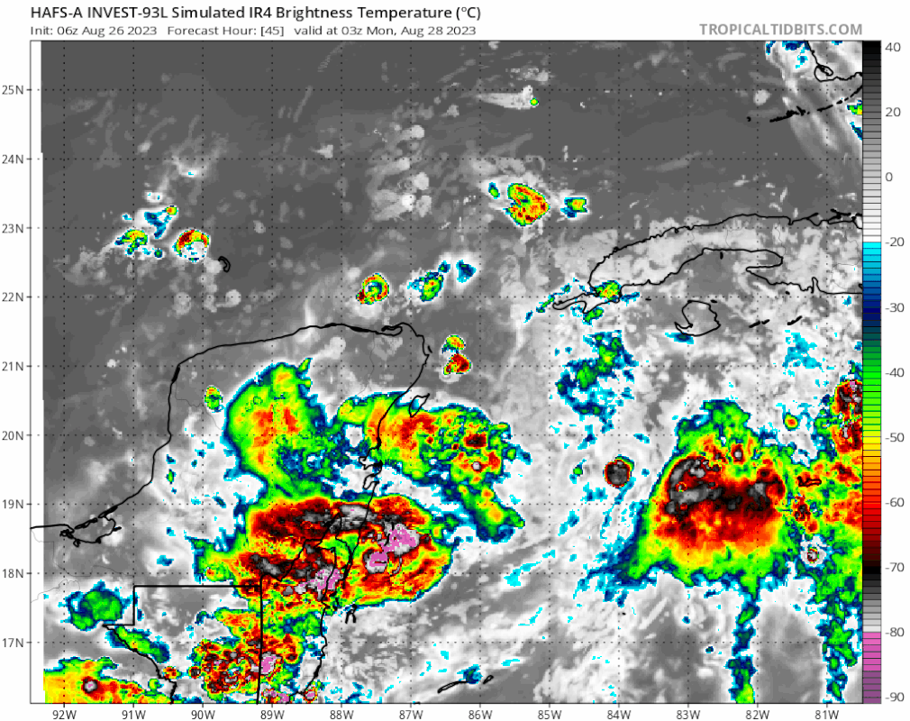
Re: ATL: INVEST 93L - Models
HAFS-A similar to Euro track. GFS likely too far west. Has a strengthening storm (hurricane) passing just north of Tampa.
Last edited by gatorcane on Sat Aug 26, 2023 6:45 am, edited 2 times in total.
0 likes
Re: ATL: INVEST 93L - Models
Stormlover1970 wrote:pasco / hernando?wxman57 wrote:GFS is likely too far west. Euro doesn't look too bad. Inland north of Tampa Wednesday morning as a moderate TS. Will be SW shear as it tracks toward Fl, pushing most squalls east of its center. Hurricane strength not likely, but not impossible. Maybe 50-55 kts at landfall.
It's close enough to Pasco and Pinellas to consider it a hit if that happens so prepare for the forecasted strength
1 likes
-
jlauderdal
- S2K Supporter
- Posts: 7240
- Joined: Wed May 19, 2004 5:46 am
- Location: NE Fort Lauderdale
- Contact:
Re: ATL: INVEST 93L - Models
gatorcane wrote::uarrow:
HAFS-A similar to Euro track. GFS likely too far west. Has a strengthening storm (hurricane) passing just north of Tampa.
https://i.postimg.cc/XY9kY1bs/hafsa-sat-IR-93-L-fh45-96.gif
HAFS a and b were west last night, coming round to the others....still early as we have a developing system, remember ian, it was well developed and then ramped up at the end and went south in spite of the consensus, beware
1 likes
Who is online
Users browsing this forum: No registered users and 85 guests